
February 2017

Mohenjo-daro UNESCO World Heritage Site in Sindh

Mohenjo-Daro

Unlocking the Enigma of Mohenjo-Daro: A Dive into Ancient History Mohenjo-Daro also spelled as Mohenjodaro or Moenjodaro, holds a mystique as intriguing as its name, which translates to “Mound of the Dead.” This archaeological gem is nestled in the Sindh province of Pakistan, offering a window into the enigmatic Indus Valley Civilization (IVC) that thrived around 2600 BC. Mohenjo-Daro is one of the six UNESCO World Heritage Sites in Pakistan inscribed in 1980. The city’s original name remains a mystery. The Dawn of Civilization Our story begins around 5500 B.C. when a nomadic tribe settled in the villages west of the lower Indus River. These early settlers, adapting to their environment, mastered tools, constructed humble dwellings, cultivated crops, and tamed animals. Over centuries, as climate patterns evolved, lush jungles and thriving wildlife emerged. Gradually, this nascent community expanded both in size and influence, engaging in trade with regions as distant as Central Asia and the neighboring western territories. By 2600 BC, Mohenjo-Daro evolved into a civilization rivaling the sophistication of Mesopotamia and Egypt. Unveiling the Indus Valley Civilization The Indus Valley Civilization, also known as the Harappan Civilization, boasted two major cities, Harappa and Mohenjo-Daro, along with over 100 smaller settlements. It marked the dawn of urbanization in the Indian subcontinent. From 2600 B.C. to 1700 B.C., this civilization thrived on the fertile plains along the Indus River, showcasing remarkable literacy with a unique script consisting of 250-500 Dravidian characters. This civilization stands tall among the world’s great ancient cultures, with its initial discovery at Harappa in 1921, followed by Mohenjo-Daro in 1922. Rediscovery and Archaeological Endeavors The journey to resurrect Mohenjo-Daro’s glory began in 1922 when R.D. Banerji, an archaeologist with the Archaeological Survey of India, stumbled upon the site. A series of extensive excavations, overseen by renowned archaeologists, occurred until the 1930s. Later, in 1964-65, brief excavations resumed, only to be halted due to preservation challenges. Mohenjo-Daro’s sprawling ruins, stretching across approximately 750 acres, housed a peak population of around 40,000, making it one of the world’s largest and most advanced cities in its era. The city’s construction, characterized by unbaked bricks atop elevated mounds, exemplifies meticulous town planning principles. Urban Planning and Infrastructure Mohenjo-Daro’s urban layout followed a structured grid, with rectilinear buildings dominating the landscape. Most structures were constructed using standardized fired and mortared bricks, complemented by evidence of sun-dried bricks and wooden superstructures. The city comprised two main sections: the Citadel, standing 12 meters high and featuring two grand assembly halls and public baths, likely reserved for religious ceremonies, and the Lower City, comprising courtyard houses for the middle class. These houses featured brick stairs leading to flat roofs and small bathrooms equipped with drains and sanitation facilities. The Magnificent Great Bath A crowning jewel among Mohenjo-Daro’s structures is the Great Bath, astonishingly well-preserved after millennia. Measuring 180 feet by 108 feet, this structure features outer walls that are 7 to 8 feet thick, and lined with bitumen. This remarkable pool may have played a role in religious purification, with dimensions of 39 feet in length, 23 feet in width, and 8 feet in depth. Masterful Water Management Mohenjo-Daro boasted an intricate water management system, highlighted by a central marketplace well and smaller household wells. A sophisticated covered drainage system efficiently handled wastewater, while high-status residences included spacious homes with attached baths and integrated drainage. Many houses featured inner courtyards, their doors opening onto side-lanes. Achievements and Trade The people of Mohenjo-Daro exhibited advanced knowledge of weights, measures, and arithmetic with decimals. Their pottery showcased intricate geometric designs, and they crafted figurines reflecting their beliefs. Major crops included wheat, rice, mustard, dates, and cotton, while animals such as dogs, cats, camels, sheep, pigs, goats, water buffaloes, elephants, and chickens thrived. The presence of guard towers and defensive fortifications suggests that Mohenjo-Daro may have served as an administrative center. Archaeological evidence points to the city’s repeated destruction and reconstruction, with causes attributed to massive Indus River flooding or encroachment, mirroring a resilient spirit in the face of adversity. Unearthed Treasures Excavations at Mohenjo-Daro unearthed a treasure trove of antiquities. The findings include seated and standing sculptures, clay toys, pottery, stone axes, flake knives, coins, and copper and bronze artifacts. Among these, the iconic “Dancing Girl,” a 4,500-year-old bronze statue discovered in 1926, captures the imagination. Noteworthy discoveries also include the priest-king statue and a gold disc suggesting a third eye or “Bindi.” The Mysterious Decline Around 1700 B.C., a shadow fell over the Indus Valley Civilization, including Mohenjo-Daro. The precise cause of this decline remains shrouded in mystery. Theories range from shifts in the Indus River’s course to devastating floods or a decline in rainfall, leading to agricultural woes and eventual abandonment. Recent core drilling in 2015 revealed that Mohenjo-Daro’s true extent surpasses the excavated area. It is hinting at more secrets yet to be unveiled. Location and Accessibility For modern-day adventurers, the archaeological marvel of Mohenjo-Daro is situated approximately 510 km northeast of Karachi, 110 km southwest of Sukkur, and about 28 km from Larkana. Road access is available from Karachi, Bahawalpur, and Multan, making it a feasible day trip. Alternatively, Mohenjo-Daro boasts its airport, providing convenient access for travelers. Whether flying in from Karachi or taking a flight to Sukkur from major cities like Islamabad and Lahore, followed by a road journey to Moenjo-Daro, this ancient treasure is within reach, inviting you to step back in time. Intrigue and wonder continue to surround Mohenjo-Daro, beckoning explorers and historians alike to unlock the mysteries of this ancient marvel. This archaeological wonder serves as a testament to the ingenuity and resilience of a civilization lost to time. It is waiting to share its secrets with those who dare to delve into its history.

Mohenjo-Daro Read Post »

Takht-i-Bahi Monastery view with Mardan city in background

Takht-i-Bahi and Sahr-i-Bahlol

Takht-i-Bahi Monastery and Sahr-i-Bahlol Ruins in Gandhara, Pakistan In the heart of Mardan city, Khyber Pakhtunkhwa province, Pakistan, lie two historical treasures: the Takht-i-Bahi Monastery and the Sahr-i-Bahlol ruins. Both structures, dating back to the early 1st century, are situated merely 5 kilometers apart and have earned the prestigious title of UNESCO World Heritage Sites of Pakistan, a recognition bestowed upon them in 1980. Takht-i-Bahi: An Overview The name Takht-i-Bahi is a fusion of two Persian words, “Takht,” signifying “top” or “throne,” and “Bahi,” translating to “spring” or “water.” This nomenclature paints a vivid picture of a monastic complex perched atop a hill, overlooking a meandering stream. Another interpretation suggests that it could mean the “Throne of Origin.” Majestic Architecture The grandeur of the Takht-i-Bahi monastery sprawls across three interconnected spurs on a hill, rising from 36.6 meters to 152.4 meters in height. The primary structures grace the central spur, commanding a panoramic view of Mardan’s plains, accessible via a staircase boasting around 300 steps. Within this complex, you’ll find the main lower stupa court, the upper south stupa court, a Grid Monastery, an assembly hall, covered stepped passageways leading to dimly lit meditation cells, and various secular buildings. Additionally, scattered around the main complex, spread over 4 kilometers, are several units, potentially serving as residential areas or assembly halls, all visible from the hill’s summit. A Scenic Retreat The journey to the top of the Takht-i-Bahi archaeological relics hill rewards visitors with a breathtaking view. One can gaze across the plains, with Peshawar visible on one side and the Malakand Pass and Swat’s picturesque hills on the other. During winter, a thick blanket of fog sometimes envelops the region, shrouding even the nearby Takht-i-Bahi bazaar and Mardan City in an ethereal veil. Discovery and Historical Significance In 1836, the site’s existence was first noted by General Court, a French officer in the service of Maharaja Ranjit Singh. Dr. Henry Walter Bellew, a British medical officer born in India, explored it in 1864, leading to a series of excavations. Harold Hargreaves conducted further research from 1910 to 1911. The travel records of Chinese monk-pilgrim Xuanzang (602-64) also allude to this archaeological marvel. The site’s relics were mentioned for the first time in 1836 by the General Court. Dr. H.W. Bellew’s visit in 1864 resulted in a report detailing the remains and a stupa on the central spur. He also described sculptural fragments, possibly parts of large-scale sculptures. Subsequent excavations in 1871, reported by F.H. Wilcher, unearthed a total of 165 sculptural fragments, primarily depicting seated Buddhas and standing bodhisattvas. Unfortunately, the outcome of the 1911-1913 excavation was less fruitful due to inadequate record-keeping. In 1920, the site underwent significant restoration. Historically, the monastery thrived for 800 years, from the 1st century B.C. to the 7th century A.D. Archaeologists divide its history into four distinct periods: Foundation in the 1st century B.C., evidenced by inscriptions bearing the name of Gondophares (20-46 A.D.). Influence of Kushan kings, such as Kujula Kadphises and Kanishka, in the 1st and 2nd centuries. Development of the Stupa Court and Assembly Hall in the 3rd and 4th centuries. Construction of the Trantic complex with dark cells in the 6th and 7th centuries, overseen by invading Hun rulers. Architecture of Takht-i-Bahi The remains of the complex encompass four main areas: The central “Stupa Court,” features a cluster of Stupas surrounding a central courtyard. Monastic chambers, comprising individual cells arranged around a courtyard. A temple complex, housing several Stupas. Dark cells in the basement, designed exclusively for meditation. The entire structure is constructed using indigenous dressed and semi-dressed stone blocks, set in grey-colored limestone, adhering to Gandhara patterns. The site’s enduring reputation is founded on its remarkable preservation and strategic location, rendering it impervious to hostile incursions. Notably, stone sculptures from the site were relocated to the Peshawar Museum, while the stone inscription of Gondophares now resides in the Lahore Museum. Sahr-i-Bahlol: An Adjacent Enigma The second component of this historical tapestry is the Sahr-i-Bahlol ruins. Also referred to as Seri Bahlol or Sehr-i-Behlol, these ruins belong to a small fortified town from the Kushan period. A mound, approximately 9 meters high, is enclosed by a stone fortification wall. This wall, erected about 3,000 years ago, spans 9.7 hectares but has suffered damage at several points. The site holds remnants of Buddha that have not been adequately excavated. Regrettably, illegal excavations by local residents have led to the discovery of antiques such as statues, coins, jewelry, and utensils. Surrounded by fertile fields, this site now faces the threat of extinction due to ongoing construction. Access to These Treasures Takht-e-Bahi Monastery is located about 2 kilometers east of Takht-e-Bahi bazaar on the Mardan-Swat road, and approximately 15 kilometers north of Mardan city. Mardan itself is situated roughly 70 kilometers from Peshawar and can be reached within an hour and a half. The journey from Islamabad, spanning approximately 150 kilometers, takes around 2.5 hours. Both sites are suitable for a day excursion. Entry Timings: Summer: (1st April – 30th September) 08:00 am to 06:30 pm Winters: (1st October – 31st March) 09:00 am to 04:30 pm Holidays: The monastery remains open on holidays unless high-profile delegations are visiting or special instructions from higher authorities dictate otherwise. Entry tickets: For locals: Rs. 20 Foreign tourists: Rs. 500 Parking charges: All vehicle types: Rs. 50 Photography charges Applicable only to DSLR cameras: Rs. 500 Explore the rich history and architectural splendor of Takht-i-Bahi and Sahr-i-Bahlol, where the past comes to life amidst the enchanting landscapes of Gandhara, Pakistan.

Takht-i-Bahi and Sahr-i-Bahlol Read Post »

Naltar Valley

Naltar Valley

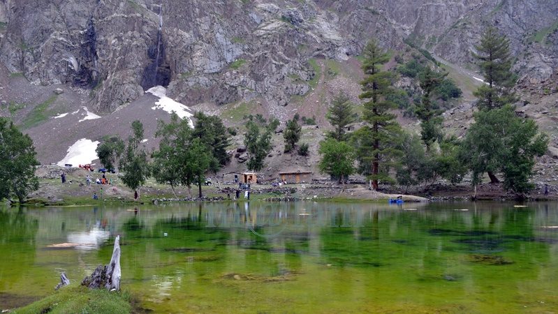
Unveiling the Beauty of Naltar Valley: A Hidden Gem in Gilgit-Baltistan Nestled majestically amidst towering mountains at an astonishing elevation of approximately 15,000 feet lies the picturesque Naltar Valley, a true jewel near the town of Gilgit in the Gilgit-Baltistan region of Pakistan. This idyllic highland boasts the dual distinction of being a perfect summer escape and a world-renowned winter ski resort, attracting both national and international skiing enthusiasts year after year. Enveloped in lush greenery, adorned with pine, spruce, birch, rowan, and juniper trees, and cradled by emerald hills and snow-capped peaks, Naltar Valley is not only a natural wonder but also home to the Gujjar tribe, renowned for cultivating delectable and oversized potatoes. Exploring Naltar Valley: Geography and Accessibility Located approximately 19 kilometers uphill from the Nomal Valley, which serves as a base and is situated at the mouth of the gorge, Naltar Valley is easily accessible. The Nomal Valley itself is a mere 20-kilometer drive from Gilgit via the western bank of the Hunza River and about 70 kilometers from Hunza Valley, accessible via the Karakoram Highway, passing through Rahimabad and crossing a sturdy concrete bridge over the Hunza River. To reach Upper Naltar (Naltar Bala or Ajeeni Naltar in the local Shina language) from Gilgit takes approximately 2.5 hours, while the journey from Hunza extends to around 4 hours. A Haven for Travelers: Tourist Attractions in Naltar Valley Naltar Valley is a haven for those seeking respite from the urban hustle and bustle or yearning for unadulterated serenity. Whether you plan a day trip or opt for an overnight stay, the valley offers various accommodation options, including the possibility of camping. Key attractions in the area include: 1. Skiing Naltar has firmly established itself as a premier winter sports destination, hosting international ski competitions. Due to its elevated location, Naltar receives a substantial amount of snow each year, making it perfect for skiing. The Ski Federation of Pakistan operates ski lifts, and every February, the valley becomes a magnet for national and international athletes. 2. Trekking Routes Naltar Valley serves as the starting point for two enchanting medium-level treks: one leading to the Naltar Pass (approximately 4,600 meters) towards the east, connecting to the Ishkoman Valley, and the other traversing the Daintar Pass (4,636 meters) westward to Chalt. A two-hour drive spanning approximately 47 kilometers from Gilgit along the western bank of the Hunza River brings you to Nomal Village, your gateway to these exciting treks. 3. Lakes The journey from Upper Naltar to the lakes covers about 13 kilometers of jeep-able road. However, when the road is impassable or washed away, a scenic walking trail opens up. These hikes take several hours on foot depending on the condition. This rugged jeep track runs alongside a rivulet, leading you to the captivating Bashkiri Lake – I, Bashkiri Lake – II, and Bashkiri Lake – III, nestled closely together at the gorge’s end. Locally, these lakes are known as “Chimo Bari (Fish Lake),” “Chakar Bari (Multi Ends Lake),” and “Bodolok Bari (Turbid Lake).” These lakes are ensconced within dense pine forests. Winters bring harsh conditions and sometimes pile up to 10 to 15 feet of snow. Summers attract hordes of local and international tourists and trekkers eager to explore this natural wonder. 4. Rivulet Glacial waters originating near the Wakhan Corridor’s border converge to form a rivulet that meanders through the gorge’s heart until it meets the Hunza River. This natural watercourse provides opportunities for activities like camping, cooking, and irrigation. These various enjoyable activities along its pristine banks, enhance the overall visitor experience. 5. Camping and Outdoor Activities Naltar Valley boasts numerous camping sites, making it ideal for overnight or weekend camping adventures. The valley’s safety and availability of fresh vegetables at reasonable prices ensure a comfortable and enjoyable stay. The hiking trails leading to breathtaking viewpoints along with its magnificent medium-range mountains, provide ample opportunities for exploration. Naltar is also famous for its diverse flora and fauna. The Weather in Naltar Valley Naltar Valley enjoys perpetually romantic weather. Even during the peak of summer, the lakeside at Naltar experiences frequent light showers, adding to the area’s allure. The ever-changing romantic weather, combined with the stunning natural scenery, makes a visit to Naltar Valley an unforgettable experience. Culinary Delights Light refreshments like tea and cookies are available for tourists at the lakeside. However, visitors planning to spend an entire day at Naltar are advised to make personal meal arrangements. Accessing Naltar Valley Please note that the new road to the Naltar Valley is under construction and accessible solely by 4WD Jeeps. Transport and camping arrangements for overnight in tents, are available for your convenience.

Naltar Valley Read Post »

Scroll to Top