October 2018

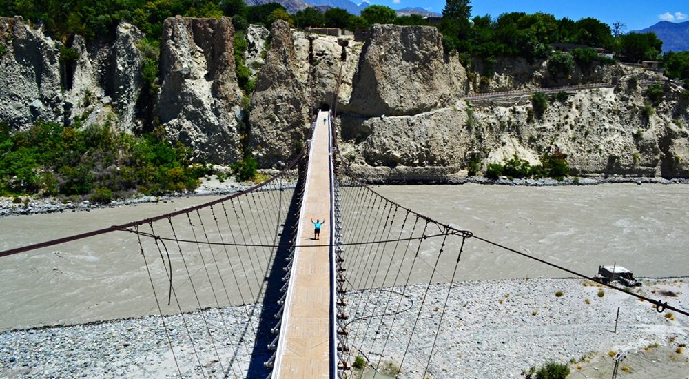
Danyore Suspension Bridge view from KIU premises

Danyore Suspension Bridge

Danyore Suspension Bridge: A Gateway to Gilgit’s History In the heart of Gilgit-Baltistan, Pakistan, lies a hidden gem called the Danyore Suspension Bridge. The bridge not only stands as a testament to engineering prowess but also weaves a tale of resilience and connectivity. The Danyore Suspension Bridge, a venerable structure, boasts a rich history that has etched its name in the annals of Gilgit’s development. Bridging the Gap Gilgit’s Historical Connection Before the Karakoram Highway breathed life into this region in 1978, Gilgit-Baltistan remained an isolated territory, isolated from the rest of the country. Poor infrastructure compounded the hardships of its residents. Gilgit, the bustling administrative hub, magnetized people from far and wide for various reasons. People had to travel to Gilgit for education, employment, trade, healthcare, or other pursuits. However, those residing to the south of Gilgit Town, separated by the Hunza River, faced daunting challenges in reaching the town. Prior to the introduction of the local raft (Jaalo) in 1945, the journey to Gilgit involved a lengthy detour. It would consume nearly an entire day—a stark contrast to the mere 15 to 20 minutes it takes today. Pioneering Vision The pressing need for a bridge became apparent. The residents of Danyore and the southern regions rallied together to generate a substantial fund of Rs. 20,000 in the late 1950s. The initial attempt to construct a suspension bridge ended in tragedy. The Hunza River, in its capricious nature, washed it away due to its close proximity to the riverbed. Undaunted, the community selected a higher location for a new bridge. Each household contributed both funds and construction wood, culminating in the successful completion of the present-day suspension bridge in 1960. A Lifeline for Generations For over half a century, the Danyore Suspension Bridge has been a reliable conduit for travelers to Gilgit, mitigating the hardships faced by frequent commuters. Unlike the local raft, which operated only during daylight hours, the bridge provided round-the-clock, hassle-free passage, significantly enhancing the quality of life for residents. The Art of Construction Masterful Craftsmanship The bridge’s construction was overseen by Ahmed Ali, popularly known as “Thikedar Bereno,” a celebrated builder and self-taught engineer from Hunza, renowned for his exceptional construction skills, particularly in bridge projects throughout Gilgit-Baltistan. Work on the Danyore Suspension Bridge commenced in 1957 and concluded in 1960. The primary tasks included erecting the bridge over the Hunza River and excavating a single-lane curved tunnel to the south, connecting to Danyore—a remarkable feat accomplished by local laborers without sophisticated engineering equipment. A Spectacle to Behold Situated nearly 2 km upstream from the confluence of the Hunza River and the Gilgit River, the bridge was initially designed for mini-vehicle use until the construction of an alternative concrete bridge. The western end of the suspension bridge leads to the KIU campus, providing access to Gilgit town, while the eastern end connects to a single-lane tunnel on the Danyore side, joining the Karakoram Highway. The bridge’s location, length, and design render it one of the world’s most spectacular bridges. Crossing the bridge and navigating the tunnel requires technical finesse, putting local drivers’ skills and nerves to the test. A Transition into the Present Regrettably, the Danyore Suspension Bridge has been closed to conventional transportation due to safety concerns, now exclusively accessible to pedestrians and motorcyclists. A nearby concrete bridge has been constructed to accommodate all types of traffic. Attraction Reimagined In 2018, the Danyore Suspension Bridge underwent a transformative renovation. The approach roads on both ends of the bridge have been revitalized and adorned, transforming it into a tourist hotspot. On the Gilgit side, a significant Buddhist rock carving site awaits exploration, adding to the bridge’s allure. The nearby Chinese Graveyard, situated on the KKH, beckons as a must-visit tourist attraction. Both elevated vantage points offer spectacular views of the bridge, which stands gracefully in its lower setting. Walking across the bridge or simply gazing at its majesty promises an unforgettable experience for every visitor. The Danyore Suspension Bridge stands not only as a structural marvel but also as a testament to human determination. Its rich history, remarkable construction, and current appeal as a tourist destination make it a cherished part of Gilgit’s heritage. As travelers and tourists flock to this iconic site, they become a part of the ongoing legacy that this bridge represents.

Danyore Suspension Bridge Read Post »
Islamabad Capital City

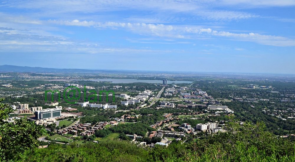
Islamabad Capital City

Islamabad – The Capital City of Pakistan Islamabad is the modern capital city of Pakistan. It is nestled in the north of the Potohar Plateau, at the foothill of the Margalla Hills. At an elevation of 507 meters above sea level, this vibrant city is strategically located in the heart of Pakistan. Moreover, the city is equipped with all types of facilities including recreational points, cycling tracks, hiking tracks, shopping malls, restaurants, parks, museums, and exhibition centers. Geographically Peshawar is 185 km (115 mi) to the east, Lahore is 295 km (183 mi) to the north and northeast, Muzaffarabad is 120 km (75 mi) to the south and southwest, and Srinagar, the capital of Indian Kashmir, is 300 km (190 mi) to the west and southwest. Historical Significance of Islamabad Islamabad undoubtedly boasts a rich history. Evidence shows ancient human settlements dating back to the Stone Age. Even some artifacts date as far back as 100,000 to 500,000 years. Moreover, excavations along the banks of the Soan River have revealed relics and human skulls from around 5000 BC. Additionally, the region has historically served as a crossroads between Punjab and Khyber Pakhtunkhwa, with the Margalla Pass acting as a gateway. The emergence of Islamabad as the Capital City After the partition of the subcontinent in 1947, Karachi became the initial capital of Pakistan. However, it was soon realized that Karachi’s location on one end of the country made it vulnerable to attacks from the Arabian Sea. Therefore, the need for a centrally located capital city with a moderate climate and easy accessibility from all parts of the country became evident. In 1958, the commission responsible for selecting the capital city chose the area that would become Islamabad. The selection was made by considering its proximity to the army headquarters in Rawalpindi and the disputed territory of Kashmir in the north. Development and Layout The construction of Islamabad as a forward capital began in 1960. Planned by a Greek firm of architects called Konstantinos Apostolos Doxiadis, the city follows a grid scheme and is triangular, with its apex facing the Margalla Hills. The capital territory is further divided into eight zones. Each zone is particularly designated for specific purposes like administrative, commercial, educational, industrial, and diplomatic activities. Moreover, The residential areas, rural zones, and green spaces provide a harmonious living environment. The city’s layout is well-organized, with lettered sectors from A to I, each further divided into four numbered sub-sectors. Therefore, clear demarcation makes navigation easy and allows for convenient addressing. Climate and Environment Islamabad experiences a unique climate characterized by hot summers with a monsoon season and mild winters. Three artificial reservoirs, including Rawal Lake, Simli Dam, and Khanpur Dam, regulate the city’s micro-climate. For instance, summers, from May to July, are the hottest months, with temperatures averaging around 40 degrees Celsius. Likewise, the monsoon season, spanning July through September, brings heavy rainfall and thunderstorms. Notable was July 1995 recorded the highest monthly rainfall of 743.3 millimeters (29.26 in). Winters, from October to March, vary in temperature depending on the location, with the lowest recorded temperature of -6 degrees Celsius occurring on January 17, 1967. Things to Do in Islamabad Islamabad offers a plethora of exciting activities for visitors and locals alike. Some popular Tourist Attractions in Islamabad to be explored include: Hiking Trails The city offers a network of specially designed hiking trails. Major hiking trails are Trail 1, Trail 2, Trail 3, Trail 4, Trail 5, and Trail 6, besides Saidpur Trail and Bari Imam Trail, catering to outdoor enthusiasts. Museums and Tourist Places History lovers and culture enthusiasts can explore the various museums and tourist attractions within Islamabad. Fishing in Rawal Lake Fishing enthusiasts can enjoy their favorite pastime in the picturesque setting of Rawal Lake. Paragliding on the Margalla Hills Thrill-seekers can experience the exhilaration of paragliding while taking in breathtaking views from the Margalla Hills. Cycling Designated cycling routes across Islamabad provide an excellent opportunity for cyclists to explore the city’s scenic beauty. Day Excursions from Islamabad Visitors can venture to nearby attractions in the nearest destinations in Punjab, KPK, and Kashmir as memorable day excursions from Islamabad. Shopping Delights Islamabad’s well-planned layout includes central shopping malls in each sector. The city offers a wide range of local and international brands at reasonable prices. The popular markets, such as F6 Markaz (Supermarket), F7 Markaz (Jinnah Super Market), F8 Markaz (Ayub Market), G6 Markaz (Melody Park), and G9 Markaz (Karachi Company), each have their distinct charm and shopping options. Culinary Adventures The city of Islamabad boasts a diverse culinary scene, catering to various tastes and preferences. From star hotel restaurants to international chains and local food joints, visitors can savor Chinese, Thai, Italian, and local cuisines, among others. How to Reach Islamabad By Air Islamabad can be reached via the Benazir Bhutto International Airport (IATA: ISB). Flights arriving from numerous international destinations include Dubai, Qatar, Abu Dhabi, London, Thailand, Sri Lanka, and China. By Bus Well-established local transport companies, such as Skyways, Faisal Movers, Niazi Express, and Daewoo Sammi, offer international standard long-haul bus services. Moreover, direct travel is available from major cities in Pakistan, including Karachi, Multan, Bahawalpur, Faisalabad, Lahore, and Peshawar. Additionally, these companies have arrangements made to transport passengers to offices within the twin cities. By Train Rawalpindi is well-connected by train to major cities, making it possible to reach Islamabad by train. Islamabad, with its rich history, well-planned layout, and diverse offerings, obviously stands as a testament to Pakistan’s progress and development. From its fascinating historical sites to its modern amenities and attractions, Islamabad invites visitors to explore its beauty and charm. Whether one seeks adventure, cultural experiences, or simply wants to enjoy a relaxing time in a dynamic city, Islamabad has something to offer for everyone.

Islamabad Capital City Read Post »

Khunjarab Pass

Khunjerab Pass

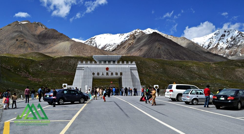
Discover the Khunjerab Pass: A High-Elevation Gateway The Khunjerab Pass, nestled at a breathtaking altitude of 4,700 meters, stands as the world’s highest paved international border crossing. It serves as a crucial junction linking the Gilgit-Baltistan region in northern Pakistan to China’s western Xinjiang province. This article delves into the beauty and significance of this remarkable pass, highlighting its construction, attractions, and access. Khunjerab Pass: A Natural Wonder Situated amidst the majestic Karakoram Mountains, the Khunjerab Pass, often referred to as Khunzerav, boasts expansive snow-capped peaks. During the summer months, this area transforms into a haven adorned with a kaleidoscope of wildflowers, creating a striking contrast against the glistening snow-clad mountains. The Khunjerab Pass offers some of the world’s most awe-inspiring scenery. The Birth of Hunza River This pass is the birthplace of the Hunza River. The snowmelt from the surrounding peaks converges to form a pristine creek that flows downward. Several of these tributaries ultimately merge to create the Hunza River, which eventually meets the Gilgit River in Gilgit. The Gilgit River continues its journey along the Karakoram Highway, eventually merging with the River Indus at the convergence of three mountain ranges before flowing onward to Thakot. Construction of the Khunjerab Pass Before the construction of the Karakoram Highway (KKH), the primary passes on the Karakoram Range were Kilik and Mintaka Passes to the north of Khunjerab. The decision to choose the Khunjerab Pass for the KKH was rooted in technical considerations. Kilik and Mintaka were deemed more vulnerable to air strikes. Consequently, Khunjerab was recommended in 1966 and realized in 1978. Attractions at Khunjerab Pass The Khunjerab Pass stands as a major tourist attraction, drawing both domestic and international visitors daily. The entire Karakoram Highway is a treasure trove of natural wonders and man-made marvels. At every turn, travelers are treated to breathtaking panoramas and opportunities for short hikes and photography. A journey along the highway to the border area promises a lifetime of unforgettable experiences. Khunjerab National Park A substantial portion of the Khunjerab Pass is enveloped by the Khunjerab National Park, established in 1979 to safeguard endangered species. Within the park’s boundaries dwell rare animals like the Marco Polo sheep and the elusive Snow Leopard. From the border area, visitors can gaze across the border into China’s Xinjiang province. Access to Khunjerab Pass Access to the Khunjerab Pass varies by location: Pakistani Side Sost Customs and Immigration Check Post: 75 km Hunza: 180 km Gilgit Airport: 280 km Islamabad (Capital City): 890 km Chinese Side Tashkurgan: 130 km Kashgar: Approximately 420 km Urumqui: 1,890 km Informative road signs provide tourists with distance-related information. It’s worth noting that traffic follows a right-hand drive on the Chinese side and a left-hand drive on the Pakistani side, making the border the transition point. Travel Tips While the Pakistani side of the highway is well-paved, the steep altitude gain near the pass can slow down your journey. Additionally, checkpoints on both sides can lead to further delays. On the Pakistani side, an entry fee is applicable to both local and international tourists. At present, the fee stands at Rs. 40 for Pakistani tourists and $8 for international tourists. It’s advisable to check for annual revisions of these fees to manage expenses, especially for larger groups. The Khunjerab Pass is open for trade and tourism from May to November. During the remaining months, it remains closed due to heavy snowfall. In November, the extreme cold and strong winds can make the visit challenging. However, under favorable weather conditions, it remains a must-visit destination. Bus Service A daily bus service operates between Sost, the last human settlement along the KKH in Pakistan, and Tashkurgan in China. Both Pakistani and Chinese buses provide transportation from their respective stations in their home countries. Travelers can also hire private cars or 4WD vehicles from Sost to Tashkurgan for drop-off and continue their journey to Kashgar using shared rides or taxis. Precautions for a Safe Journey Due to the high altitude, some tourists may experience altitude sickness, characterized by dizziness, headaches, or shortness of breath. It’s advisable to descend to lower altitudes immediately or carry altitude sickness medication in advance. During peak summer, there’s a risk of flooding due to rapid snowmelt near the pass, so a timely return is recommended. Additionally, loose gravel, especially during rainfall, can pose hazards on the highway. Whether you’re on a motorcycle or driving a car, exercise caution and avoid overconfidence. Despite renovations, the Karakoram Highway has claimed lives, particularly among tourists from lower-altitude cities. It’s essential to familiarize yourself with the entire highway before embarking on a self-drive tour. Embrace the journey and return home with cherished memories. Before You Go Pakistani tourists must carry their CNIC, while foreign tourists require a passport for identification. Foreign tourists and Pakistani nationals traveling to China must obtain a Chinese Visa (a pass for residents of Gilgit-Baltistan traveling to the nearby city of Kashgar). Buses from Sost to Tashkurgan depart in the morning between 8:00 AM and 9:00 AM, so purchasing tickets in advance is advisable. If you prefer to hire a car, private Pakistani vehicles are allowed to travel all the way to Kashgar. The fare is negotiable and not fixed.

Khunjerab Pass Read Post »

Here the great mountain ranges of the Karakoram, Hindukush, and Himalaya converge

Junction Point of Three Mountain Ranges

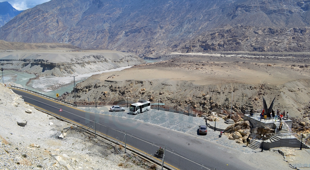
Unlocking the Secrets of the “Junction Point” of Three Majestic Mountain Ranges If you’re a true adventurer and nature enthusiast, there’s a hidden gem near Jaglot, just 40 kilometers southeast of Gilgit, Pakistan, that you absolutely must explore. It’s the awe-inspiring convergence of three of the world’s most famous mountain ranges: the Karakoram (known for its black gravel), the Himalaya (home of perpetual snow), and the Hindukush (aptly named the “killer of Hindus”). This unique location is often referred to as the “Junction Point of the world’s three great mountain ranges.” What’s more, this exceptional site also marks the meeting of the Gilgit and Indus Rivers, and the starting point of the Skardu road branching off from the Karakoram Highway (KKH). Geographic Significance: Where Worlds Collide The Junction Point isn’t just significant locally; it holds a unique place on the global stage. Pakistan is the only country where these three renowned mountain ranges converge, each boasting its highest peaks. Nanga Parbat, K-2, and Terich Mir are the standout peaks in the Himalayas, Karakoram, and Hindukush, respectively. These three ranges are considered sub-ranges of the mighty Himalayas, known as the trans-Himalayas. Standing at this point allows you to easily discern the direction of each mountain range. The Himalayan range lies to the south and east of the Indus River. The Karakoram range extends northeast from the Gilgit River, while to the west of the Gilgit and Indus Rivers, you’ll find the Hindu-Kush range. Exploring the Mountain Ranges: A Journey to Remember Karakoram Range: A World of Wonders The Karakoram Range, spanning approximately 500 kilometers, straddles the borders of Pakistan, India, and China. Within a radius of just 160 kilometers, it boasts the highest concentration of peaks soaring above 5,500 meters, numbering over 100. The crowning jewel of this range is K-2, the second-highest peak in the world, standing tall at 8,611 meters. The Karakoram is home to some of the planet’s longest glaciers, including Siachen, Batura, Baltoro, Biafo, Hisper, Gondogoro, and Chogolisa, making it one of the most heavily glaciated regions outside the Polar Regions. Himalayan Range: Nanga Parbat and Beyond The Himalayan range features Pakistan’s second-highest peak, Nanga Parbat, standing at an imposing 8,126 meters. Known as the “killer mountain” due to its formidable reputation, Nanga Parbat dominates the Astor District. The Great Himalayan Range stretches across 2,400 kilometers, encompassing Pakistan, Nepal, and India. Mount Everest, the world’s highest peak at 8,848 meters, calls Nepal home within this range. Hindu Kush Range: A Journey into History The Hindu Kush Range, spanning nearly 9,600 kilometers, is a land of its own wonders. While it primarily hosts smaller peaks, most standing below 7,500 meters, it covers the peaks of the Ghizer, Yasin, and Ishkoman valleys in Pakistan. The range reaches its zenith with Terich Mir, standing proudly at 7,708 meters in the district of Khyber Pakhtunkhwa. The Hindu Kush stretches from the Pamirs to Iran, offering a fascinating journey through history and geography. A Tourist’s Paradise: Unveiling the Junction Point A visit to this captivating site is a must for any traveler. It provides not only an educational experience but also a breathtaking panorama of the entire region, from the confluence of the Gilgit and Indus Rivers to the meeting of the three mighty mountain ranges. Local folklore weaves tales of the Junction Point being the residence of Jinns and fairies. Legend has it that these supernatural beings frequented the confluence of the rivers, using the waters for drinking and bathing. The Site: Your Gateway to Adventure An elevated platform, accessible by stairs, stands proudly on the edge of the Karakoram Highway. It offers a 360-degree view of the region and provides detailed information about the mountain coordinates. Adequate parking facilities are available for vehicles, and informative signboards offer essential information about the site. Regrettably, many, both within the country and from abroad, remain unaware of the significance of this captivating land. While some domestic tourists, particularly those traveling by public transport or passing by during odd hours or in the darkness, miss this gem, international tourists often include it as a vital stop on their itinerary. Best Time to Embark on Your Adventure The Karakoram Highway remains open year-round, allowing you to visit or pass by this unique site at any time of the year. However, the ideal time to explore Gilgit-Baltistan is from March to November, as the region’s winters can be harsh and freezing. Don’t miss the chance to stand at the crossroads of three remarkable mountain ranges, where nature’s grandeur knows no bounds. Visit Junction Point of Three Mountain Ranges, and let the magic of Pakistan’s unparalleled geography and history captivate your senses.

Junction Point of Three Mountain Ranges Read Post »

Rakaposhi

Rakaposhi

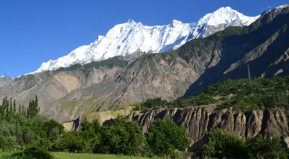
Unveiling the Magnificence of Rakaposhi: Pakistan’s Spectacular Mountain Rakaposhi is a renowned mountain peak nestled in the majestic Karakoram mountain range of Pakistan. It proudly graces the Nagar valley of Gilgit-Baltistan, flanked by the enchanting landscapes of Bagrot and Danyore. Standing tall as the 27th highest peak globally and holding the prestigious rank of being the 12th highest in Pakistan, Rakaposhi derives its name from the local vernacular, translating to “Snow Covered.” Locally, it is affectionately referred to as Bilchhar Dumani, signifying “Mother of Mist” or “Mother of Clouds.” A Breathtaking Encounter The journey to Rakaposhi’s awe-inspiring presence begins when one embarks on the Karakoram Highway (KKH) from Gilgit to Hunza. Opposite Kino Kutto, a rocky mountain aptly named in the local Shina language as “Black Knee” due to its shape, you are granted the first and most splendid glimpse of this majestic peak. While this spot is often referred to as the “Rakaposhi viewpoint,” the pinnacle of views lies in Ghulmet. Here, you are treated to a broader and more stunning panorama of Rakaposhi. The picturesque Jaffarabad village serves as a backdrop, marking your entry into the magical realm of the Hunza Valley. A Scenic Journey The scenic vistas of Rakaposhi continue to unfold as you journey along the Karakoram Highway, tracing your way through the Hunza Valley. However, if you opt to travel from the opposite side of the Hunza River, specifically through the lower Hunza or Shinaki valleys (including Khizr Abad, Hussainabad, Mayun, and Khanabad), you’ll be treated to captivating facets of Rakaposhi. The mountain reveals itself in all its glory, offering a different perspective on this natural wonder. To reach the Ghulmet viewpoint, situated approximately 5 km short of the main viewpoint, you can rejoin the Karakoram Highway. Ghulmet village, home to the famous viewpoint, lies roughly 75 km from Gilgit and is a favored vacation destination for travelers seeking Rakaposhi’s grandeur. An Unparalleled Ascent One of Rakaposhi’s most remarkable features is its astounding elevation gain of 5900 meters over a mere 11.2 kilometers of horizontal distance from the Hunza-Nagar River. It stands as the sole mountain peak worldwide that ascends directly from fertile cultivated fields. Rakaposhi’s distinction arises not merely from its rank but from the sheer magnificence it embodies. A Triumph in History The first successful ascent of Rakaposhi was achieved in 1958 by Mike Banks and Tom Patey, who undertook the challenging Southwest Spur/Ridge route. Their conquest, while awe-inspiring, came at the cost of minor frostbite. Tragically, another climber slipped and lost their life during the descent on that fateful night. A Sanctuary of Biodiversity The people of Nagar have dedicated the extended Rakaposhi Mountain region as a national park. It’s indeed a noble initiative inaugurated by the Minister for Northern Areas. This sanctuary is home to several endangered species. These include Marco Polo sheep, Snow Leopards, wolves, and a diverse array of wildlife. Rakaposhi’s natural beauty not only captivates the eye but also safeguards the precious biodiversity thriving within its vicinity. Rakaposhi stands not only as a symbol of natural wonder but also as a testament to human triumph and conservation efforts. Its allure continues to draw adventurers, nature enthusiasts, and conservationists. Additionally, this majestic mountain offers a profound connection with the splendor of the Karakoram mountain range. Besides, it boasts a rich tapestry of Pakistan’s natural heritage.

Rakaposhi Read Post »

Rakaposhi View Point from the Karakoram Highway

Rakaposhi View Point

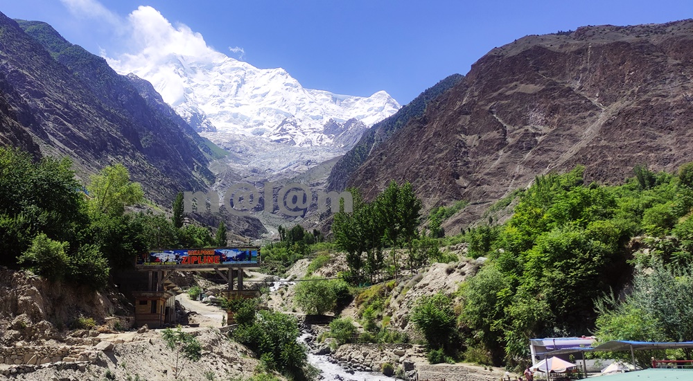
Rakaposhi View Point -A Close Encounter With The Shining Wall The Rakaposhi View Point undoubtedly stands as a testament to the unparalleled beauty of nature. The view point is situated in Ghulmet village, on the main Karakoram Highway, within the enchanting Nagar Valley. This extraordinary viewpoint offers an up-close and personal encounter with the awe-inspiring Rakaposhi mountain. Karakoram Highway: A Tapestry of Marvels The Karakoram Highway is much more than a mere asphalt artery connecting Pakistan and China through the Khunjerab Pass. It’s a highway especially adorned with a treasure trove of tourist attractions. The highway boasts natural wonders, archaeological marvels, cultural heritage, and architectural splendors. It beckons travelers to pause and immerse themselves in its allure. Rakaposhi View Point, nestled along this route, stands out as a prime exemplar of pristine natural beauty. An Oasis Amidst the Journey When traversing the road between Gilgit and Hunza, seasoned travelers always include a mandatory stop at Rakaposhi View Point. The shadow of Rakaposhi is the 27th highest peak globally, soaring at an elevation of 7,788 meters. Here one can find solace and delight in the lap of unparalelled natural grandeur. Moreover, the locale offers small terraces thoughtfully designed along the glacier-fed stream, inviting tourists to relish moments of relaxation, savor delicious meals, and capture stunning vistas. Summer Serenity: Immersing in Nature’s Bliss During the summer season, tourists revel in the joy of sitting by the stream, dipping their feet into the refreshing glacier water. Furthermore, this site is ideal for capturing the picturesque surroundings through their lenses. The symphony of flowing water, the verdant embrace of nature, and the grandeur of Rakaposhi provide an unforgettable experience. Evolution of Rakaposhi View Point The journey of Rakaposhi View Point from obscurity to acclaim has been nothing short of remarkable. The gradual surge in tourist footfall led to its growing prominence, which in turn catalyzed infrastructure development in the vicinity. The site boasts a plethora of attractions including the glacier nestled in greenery and the meandering stream driving a gentle breeze. In its nascent stage, Rakaposhi View Point was no more than a humble gift shop and a local eatery, primarily serving the needs of nearby travelers. Over time, local entrepreneurs embraced the opportunity, resulting in the establishment of gift shops, handicraft stores, convenience shops, restaurants, campsites, and even upscale tourist accommodations. A new road has been constructed, providing closer access to the glacier emanating from Rakaposhi, and work is underway to develop additional tourist attractions. The future holds the promise of turning this site into a premier tourist destination. Culinary Delights and More For travelers journeying between Gilgit and Hunza, Rakaposhi View Point stands as an ideal spot for a leisurely and sumptuous breakfast or an open-air lunch with breathtaking views. Not to be missed is the local specialty, “Chap-Shuro,” a unique kind of local pizza. The menu offers an array of fresh local cuisine at budget-friendly prices. Here, you can always count on delectable food coupled with personalized service. Rakaposhi View Point is not just a stopping point on your journey; it’s an invitation to immerse yourself in nature’s grandeur and indulge in local delights. Visit and be captivated by the magic of Rakaposhi and the wonders that surround it.

Rakaposhi View Point Read Post »

Scroll to Top