Author name: admin

Excursions from Skardu
City Breaks, Gilgit-Baltistan, Tourists Destinations in Pakistan

Excursions from Skardu

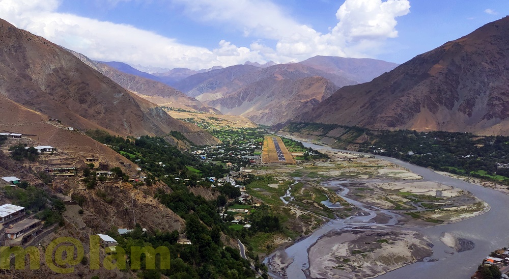
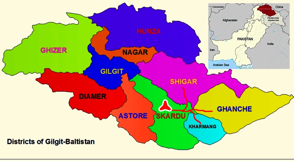
Excursions from Skardu – Explore the Mesmerizing Beauty Skardu, located in Gilgit-Baltistan, Pakistan, is a gateway to some of the world’s highest mountains and longest glaciers. As the capital of the Baltistan Division, one of the three divisions (Gilgit, Diamer, and Baltistan) of Gilgit-Baltistan, Skardu is one of the four key districts (Skardu, Shigar, Ghanche, and Kharmang) in the Baltistan Division. Each district is renowned for its unique manmade and natural attractions that draw tourists. Skardu serves as an excellent base for exploring the area’s key attractions. Recommended day excursions from Skardu include: Day Excursion to Shigar Valley Shigar Valley, situated in the Shigar District of Gilgit-Baltistan, is renowned for its stunning landscapes and tranquil ambiance. Surrounded by towering mountains, cascading waterfalls, and crystal-clear rivers, the valley is a paradise for nature enthusiasts. It offers a perfect escape from bustling city life, allowing visitors to immerse themselves in the wonders of the great outdoors. As a former princely state and one of the four districts of the Baltistan Division, Shigar is the nearest and most conveniently accessible destination. Located just 45 km away and reachable within an hour, Shigar boasts a range of exclusive tourist attractions, from historical sites to natural sceneries, including: Sarfaranga Desert The Cold Desert, located in Sarfaranga village in Skardu, Gilgit-Baltistan, is the world’s highest desert, standing at an altitude of nearly 7,500 feet. Known as the Sarfaranga Desert or Skardu Cold Desert, it is one of the two most famous icy deserts in the region. Situated close to Skardu, it is accessible with a 30-minute drive. Nestled in the Shigar Valley along the Indus River and surrounded by mountains, it serves as an excellent capstone experience for a trip to the Shigar area. The Sarfaranga Cold Desert is a hub of touristic activities, offering desert jeep safaris, motor gliding, biking, horse riding, and more. Blind Lake Blind LakeBlind Lake, also known as Xarba Tso in the local Balti language, is an enchanting freshwater lake nestled near the Shigar Valley in the heart of the Gilgit-Baltistan region of Pakistan. Unlike most lakes, Blind Lake does not rely on any external water supply or discharge source. Its serene waters remain still and unmoving, earning it the intriguing name “Blind Lake.” This mesmerizing lake offers panoramic views of its surroundings, particularly the riverside and the majestic mountains that serve as its backdrop. The trail leading to Blind Lake is a unique journey through lush greenery, arid deserts, and rugged rocky hills. Visitors can enjoy key activities like boating, camping, and musical events. There are a few tuck shops providing basic necessary items for tourists, and entry to the lakeside is subject to a fee. Shigar Serena Fort Palace The Shigar Fort in Skardu Valley is a remarkable architectural structure surrounded by Shigar’s vast plains. Renowned for its historical significance, Shigar Fort is the most visited location in Skardu. Constructed roughly 400 years ago, the entire structure is composed of stones with sturdy foundations. Formerly known as the Palace of Rock, the fort has been transformed into a guesthouse featuring 20 rooms and a large hall displaying treasures of the Baltit culture. Amburiq Mosque The Amburiq Mosque is one of the oldest mosques in Baltistan and is a renowned landmark in the region. Built by Sayed Ali Hamdani, it holds great historical significance. According to local traditions, Sayed Ali Hamdani visited Shigar to spread the faith and established the Amburiq Mosque, making it the first mosque in the Shigar Valley. A small museum inside the mosque raises awareness about its historical importance and encourages the local community to adopt a conservationist approach towards culturally significant structures. The mosque underwent restoration between 1998 and 2000. In 2005, UNESCO awarded the mosque the Asia-Pacific Heritage Award. Khanqah-e-Mualla With the dawn of Islam in the Baltistan region in 1352 through Amir Kabir Syed Ali Hamadani, the construction of small mosques became common. One of the most monumental pieces from that era is Khanqah-e-Mualla, a valuable gift to the Shigar Valley. The credit for its establishment goes to Shah Nasir Tusi, who came from Tus, Iran, with his three daughters through the Siachen Glacier in 1591. Shah Nasir laid the foundation of the Khanqah in 1602. According to local folklore, he disappeared near the mountains of the Braldu Valley on his way to K2. The construction, materials, and design of the Khanqah have remained unchanged for more than four hundred years. Although it has undergone repairs multiple times, the materials and construction methods have always stayed the same. Hashupi Garden Hashupi Bagh, also known as Hashupi Garden, is the Apple and Cherry Garden nestled in the picturesque Shigar Valley. This magnificent garden is located amidst the majestic Karakoram Mountains in Gilgit-Baltistan, Pakistan. Hashupi Bagh is a haven for nature lovers and adventure seekers alike. Apart from its apple orchards, the garden features stunning cherry blossoms that bloom during the spring season, transforming the landscape into a spectacle of delicate pink and white flowers. The cherry blossoms create a magical ambiance, drawing photographers, nature enthusiasts, and romantics. Visitors can wander through the garden, marveling at the ethereal beauty of the blossoms and capturing unforgettable moments. In autumn, Hashupi Bagh bursts with vibrant colors as the apples and cherries ripen, ready to be harvested. Chuturon Hot Springs Chotron Hot Springs is a natural hot spring located in the Shigar district of Gilgit-Baltistan, Pakistan. Situated at an elevation of around 2,400 meters (7,874 feet) above sea level, it is surrounded by beautiful mountains and forests. The water in the hot spring is naturally heated by geothermal activity and is believed to have medicinal properties due to its high mineral content. The mineral water of these springs contains elements like sodium, potassium, calcium, magnesium, chlorides, fluorides, sulfates, phosphates, and bicarbonates, which may be responsible for curing various diseases. However, the water from the thermal springs of Chotron is unsuitable for drinking due to its high fluoride content and the presence of small amounts of total coliforms,

Sirikot Muzaffarabad
Kashmir, Tourists Destinations in Pakistan

Sirikot, Muzaffarabad

Escape to Serenity: Srikot, Azad Kashmir’s Untouched Wilderness The term “Sirikot” originates from the fusion of two words: “Siri,” which translates to “top,” and “kot,” meaning “village” in the local language. Together, they signify a “village at the top” or a “hill-top village,” reflecting its mountainous geographical setting. Situated at an altitude of approximately 2125 meters (6,970 feet), Sirikot boasts a long stretch of green meadow extending over a kilometer in length, surrounded by dense hilly forests in Muzaffarabad district of Azad Kashmir. During the summer months, it is an ideal destination for either a day trip or an overnight stay. Shaheed Gali The tiny valley of Shaheed Gali serves as the starting point for the adventure to Sirikot. Tourists can drive their own vehicles up to Shaheed Gali, where there’s a parking lot near the police station. From there, the route continues with an uphill rough jeep track, suitable only for Willis Jeeps or off-road vehicles. Visitors have the option to hire a jeep for approximately Rs. 3500 to Rs. 4,000 for a short round trip. However, prices for overnight stays are negotiable. The journey by jeep takes about 45 minutes to reach Sirikot. Sirikot: The Most Serene and Mesmerizing Hilltop Emerges as the most serene and mesmerizing hilltop in the Kashmir region, Sirikot is nestled along the border of the Khyber Pakhtunkhwa province. The voyage to Sirikot unveils breathtaking vistas of AJK Muzaffarabad city and mountaintop villages, characterized by steep ascents and adventurous trails flanked by towering Pine trees, crafting a picturesque setting. The delightful climate further enhances the allure, inviting visitors to a locale imbued with tranquil potency, stirring the soul and igniting introspection. Despite the road challenges, the stunning landscape, dense pine forests, and cool climate render Sirikot a standout attraction in Muzaffarabad. Adventure enthusiasts are strongly encouraged to opt for hiking from Shaheed Gali to Sirikot if time and energy permit. The trek takes approximately 2.5 to 3 hours to reach the summit. However, travelers also have the option to hire a jeep from Shaheed Gali to reach Sirikot. From Muzaffarabad to Shaheed Gali, there is a well-maintained metal road accessible to all types of vehicles, including bikes, cars, vans, and Saloon Coasters. However, beyond Shaheed Gali, only jeeps are recommended for the journey. Sirikot holds significant renown among tourists and locals alike, owing to its high altitude and stunning scenic landscapes. While traversing from Shaheed Gali, one can relish picturesque vistas of the valleys and mountains spanning Azad Kashmir and Khyber Pakhtunkhwa. These encompass Muzaffarabad, Garhi Habibullah, Shaheed Gali, the beautiful Neelum Road, and other surrounding regions. Food & Accommodation Sirikot is a destination perfect for a short visit, offering tranquility and celestial beauty. Natural splendor harmonizes with prevailing peace, providing serene and romantic vistas. At the top of Sirikot, there’s a captivating rest house where visitors can stay. Additionally, food points are available during the visiting season, ensuring a delightful experience for all. Sirikot weather Sirikot experiences a range of weather conditions throughout the year. Spring marks the beginning of its beauty, transitioning into warm summers and eventually transforming into snowy winters. The area receives a significant amount of snowfall during the winter season. Due to its altitude and the abundance of forests and greenery, Sirikot enjoys pleasantly cool weather during the summer months. The average temperature during summer ranges from 18 to 30 degrees Celsius, while in winter, it drops significantly to around -2 degrees Celsius, accompanied by heavy snowfall. Things to do at Sri Kot  There are various activities to enjoy at Sirikot: Sports: Engage in sports activities like football, volleyball, badminton, frisbee, or cricket. There’s a cricket pitch available for enthusiasts to play matches or any sport of their choice. Camping: Rent a room at a nearby rest house or set up your own camp on the beautiful hilltop of Sirikot. Barbecue: Enhance your experience by arranging a bonfire or barbecue at this serene location. Musical Events: Host musical events to add to the ambiance and enjoyment. Nature Scavenger Hunt: Create a list of wilderness items and organize a scavenger hunt to find them. Wildlife Spotting: Bring binoculars and guidebooks to identify birds, insects, and other wildlife in the area. Nature Photography: Capture the beauty of the surroundings with cameras or smartphones. Yoga or Tai Chi: Practice yoga or tai chi in a peaceful natural setting. Orienteering: Set up a simple orienteering course using maps and compasses to navigate through the wilderness. Stargazing: Stay until evening and observe the stars and constellations in the night sky. Team Building: Organize team-building activities for corporate groups. Hiking: Explore the dense jungle, listen to the birds’ songs, and immerse yourself in the joy of nature. Always prioritize safety and environmental respect while enjoying outdoor activities. Access to Sirikot: Muzaffarabad serves as the capital city and primary access point, easily reachable from Islamabad and Mansehra/Abbottabad. It’s approximately a 90-minute drive from Muzaffarabad (via Neelum Road and Batamang Road) on the Azad Kashmir side, and a 70-minute drive from Garhi Habibullah on the Khyber Pakhtunkhwa side. The road leading to Shaheed Gali, from both Garhi Habibullah and Muzaffarabad, offers spectacular views of Muzaffarabad city, Pir Chinasi, and the surrounding Azad Kashmir region. However, the final 7-kilometer stretch from Shaheed Gali to Sirikot requires either an adventurous trek or a bumpy jeep ride due to rough road conditions. Emergency Assistance: AJ&K tourism police are tourist-friendly and dedicated to safeguarding privacy and ensuring safety.  Also Read: Muzaffarabad Tourist Attractions Neelum Valley Tourist Attractions Red Fort, Muzaffarabad Pir Chinasi, Muzaffarabad Gangaa Choti Leepa Valley Rawalakot

Skardu Tourist Attractions
City Breaks, Gilgit-Baltistan, Tourists Destinations in Pakistan

Skardu Tourist Attractions

Skardu – A destination beyond imagination Serving as one of the four districts of the Baltistan Division of Gilgit-Baltistan’s three divisions, Skardu is the capital city of Skardu District. Skardu is the primary gateway to the eight-thousanders of Pakistan including K2, Broad Peak, and Gasherbrum Peaks, and is also the threshold to several famous glaciers including the well-known Baltoro Glacier. Nestled at 2500m (8,202 feet) above sea level, along the bank of the Indus River, Skardu presents a harmonious blend of modern amenities and traditional appeal. The valley spans approximately 10 km in width and 40 km in length. Skardu is situated at the convergence of the Shigar River and Indus River. Renowned for its stunning landscapes, towering mountains, and distinctive cultural legacy, the region captivates visitors with its enchanting charm. Encompassed by the Karakoram Range, Skardu affords breathtaking vistas, tranquil lakes, and opportunities for trekking and mountaineering. It boasts extensive tourist attractions catering to nature enthusiasts, adventure seekers, and those intrigued by local customs. Below are some of Skardu Tourist Attractions: Kharpocho Fort  Known as Skardu Fort, the Kharpocho Fort is a significant historical landmark situated atop a rocky hill, towering 40 meters above the main town. Offering sweeping views of the surrounding landscapes, reaching the fort entails a rewarding 30-minute hike. Overlooking the confluence of the Indus and Shigar Rivers, the fort boasts a secret tunnel providing an escape route during emergencies, linking it to the city. Referred to as the “king of forts” in the local Balti language, it served as a military stronghold during various conflicts. Constructed in the late 16th century by King Ali Sher Khan Anchan, the fort features a traditional architectural style, encompassing numerous cozy rooms within its expansive boundary walls. Its intricate woodwork, majestic stonework, and skilled craftsmanship make it a captivating site to explore. Despite suffering damage during the 1948 war in Gilgit-Baltistan, the grandeur of the fort continues to allure thousands of tourists year-round. Nansoq Organic Village Nestled just beyond the famed Kharpocho Fort, The Nansoq Valley represents the inaugural organic village accessible by foot. Commencing from the nearby neighborhood adjacent to Kharpocho Fort, the trek to this picturesque village spans approximately 3 kilometers. It offers a scenic route along the Indus River with breathtaking valley views. The journey typically takes an hour via a gradually ascending path, punctuated by several wooden bridges. Approximately 75 residents, distributed among 17 or 18 families, inhabit Nansoq, embracing the traditional Balti lifestyle characterized by labor-intensive practices and a reliance on organic food. They reside in vintage-style dwellings and predominantly engage in agriculture and farming, utilizing ancient utensils. The village serves as a prime example of cultural preservation and the pursuit of a modest lifestyle. Notably, Nansoq has welcomed distinguished visitors such as Prince Charles, Prince of Wales, and the Duchess of Cornwall, underscoring its significance as a unique cultural enclave. Italian K2 Museum    The K2 Museum is a distinctive pyramid-style tent museum situated in the garden of the PTDC Motel in Skardu. It is just a 5-10 minute stroll from the city center. Sponsored by the Italian government and established in 2004, the museum commemorates the first successful summit of the treacherous K2 Mountain by an Italian expedition in 1954, led by Arditio Dezio. Dedicated to the Pakistani people and mountaineers worldwide, the museum houses a vast collection of historical data, maps, documentaries, and geographical and cultural insights about K2 Mountain and earlier expeditions to remote Baltistan, led by De Filippi. Additionally, it showcases local customs and traditional attire. The PTDC Motel itself serves as a testament to the rich climbing and hiking history in the mighty mountains of Skardu. With its wealth of exhibits and immersive experiences, the K2 Museum stands out as a remarkable tourist attraction for visitors. Manthal Buddha Rock The Manthal Buddha Rock, a sizable granite formation adorned with Buddha carvings dating back to the 8th century, resides 3 kilometers from Sadpara Road in Manthal Village, Skardu. This iconic rock boasts a prominent central carving of Buddha, flanked by two standing Metreyias (future Buddhas) and encircled by twenty small Bodhisattvas (disciples). Before Buddhism’s advent in the 4th century, Baltistan was steeped in Shamanism. Monks from northern India arrived and erected monasteries during the reign of the Palolashahi kingdom. Despite the Tibetan conquest in the 8th century, Buddhism thrived, marking the Upper Indus Valley’s “Golden Era of Buddhism” from the 8th to the 10th centuries. However, the arrival of Ali Hamadani and his followers from Iran in the 14th century transformed the region’s landscape. Buddhism waned, and places of worship fell into disrepair as Islam gained traction. By the 15th century, the region had transitioned into a predominantly Muslim state. Satpara Lake Located near Skardu, Satpara Lake is a serene and picturesque destination enveloped by towering mountains. It offers an ideal setting for boating and soaking in the natural splendor. Positioned at an impressive altitude of 2,721 meters (8,927 feet) above sea level, Satpara Lake stands out prominently amidst the rugged terrain of Skardu Valley. Fed by the Satpara stream, originating from the melting ice of Deosai Plains, the lake boasts a picturesque island that provides a tranquil retreat. With its turquoise waters set against the backdrop of lofty peaks, Satpara Lake attracts tourists from around the globe. Accessible via a 20-minute jeep ride from Skardu, it remains a popular destination for nature lovers seeking solace and scenic beauty. Katpana Desert The Katpana Desert, also known as the Cold Desert or Biama Nakpo, is a high-altitude desert near Skardu town in Gilgit-Baltistan, Pakistan. Positioned at 2,226 meters (7,303 ft) above sea level, it ranks among the world’s highest deserts. Located between Skardu airport and the town, it features vast dunes that occasionally receive a dusting of snow in winter. The desert extends from the Indus River south of Skardu to New Ranga Village in the north, with the section near Skardu town being the most famous and visited. The best time to visit is between June and September

Blossom in Gilgit-Baltistan
Blogs, Gilgit-Baltistan

Blossom in Gilgit-Baltistan

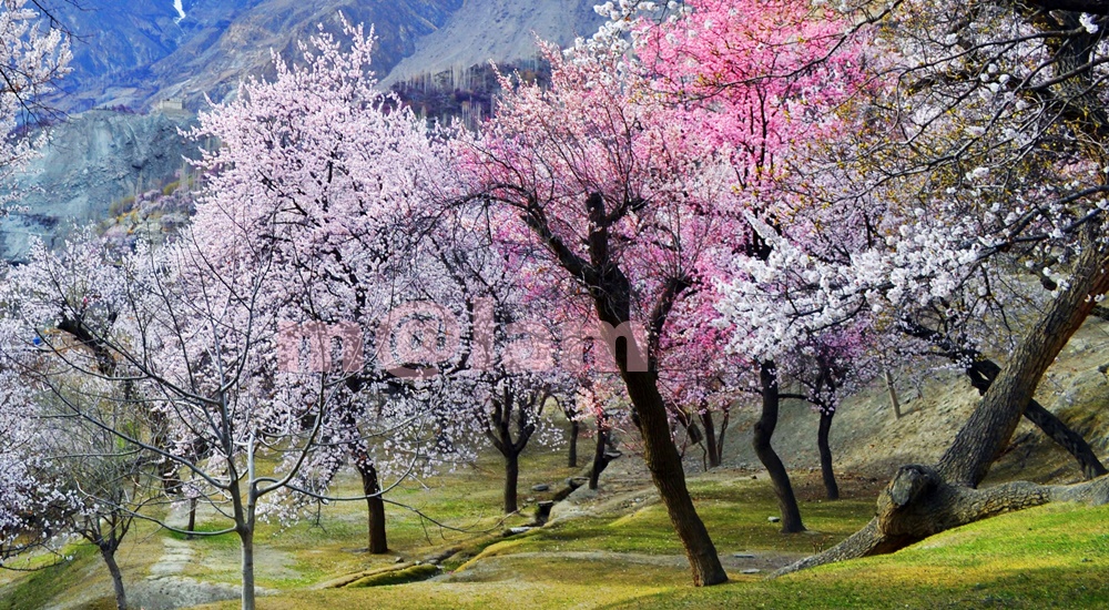
Blossom in Gilgit-Baltistan – A Breathtaking Splendor Nestled amidst the towering peaks of the Hindukush, Himalayas, and Karakoram ranges, Gilgit-Baltistan is renowned for its mesmerizing landscapes and rich cultural heritage. Blossom in Gilgit-Baltistan is a breathtaking splendor. Each spring, this region experiences a unique phenomenon where colorful blossoms transform the rugged terrain into a paradise on Earth. Particularly in tiny valleys filled with fruit orchards, the blooming trees paint a unique picture of nature against the mountainous backdrop. The journey along the Karakoram Highway, especially from Gilgit to Hunza, offers tourists a lifetime experience. Particularly because of the orchards filled with flowering trees emitting sweet fragrances. Likewise, the journey to the Phunder Valley from Gilgit, and to the Shigar and Khaplu Valleys from Skardu, presents captivating sceneries. Every turn reveals unexpected vistas of natural contrast. From blue skies to emerald rivers, The scenery captivates the soul of every beholder amidst the stark contrasts of rugged terrain and delicate blossoms. Blossoming Season in Gilgit-Baltistan The blossom season in Gilgit-Baltistan is a captivating spectacle that draws tourists from across the globe. The harmony of diverse contrasts unfolds, offering a glimpse into the sublime beauty that graces this tranquil corner of the world. The timing of these blossoms varies depending on altitude, temperature, and precipitation. Particularly, the Cherry and Apricot Blossom season is renowned for its brevity and beauty. Lasting only about two months, from March to the end of April, the Cherry blossom season enchants all who inhabit Gilgit-Baltistan with its serene and picturesque scenery. Geographical Features: Altitude: Gilgit-Baltistan’s high altitude, ranging from 1,500 to 8,000 meters above sea level, contributes to its diverse flora and fauna. The varying altitudes create microclimates conducive to different types of blossoms, from manmade orchards to wildflowers in the pastures. Climate: The region experiences a temperate climate, with cold winters and mild summers. The transition from winter to spring triggers the blossom season, usually beginning in March and lasting until April in the low-altitude regions. It lasts till June in the high-altitude valleys and pastures. This rejuvenation of nature delights every beholder with its captivating beauty. Flora and Fauna: Gilgit-Baltistan boasts a diverse range of flora, including wild roses, tulips, and various fruit trees. This rich vegetation provides vital habitats for indigenous wildlife such as ibex, snow leopards, and migratory birds. Tourist Attractions during Blossom Season This is the perfect season to explore Gilgit-Baltistan because the environment is mild and hence the weather cannot obstruct adventure activities. However, it isn’t just the weather that brings charm to Gilgit-Baltistan, but it is also the blossoming trees that create a contrast of natural colors to enchant the senses. Those lovely white and pink blossoms seldom refuse to bring joy to the visitors’ faces. Many tourists along with local people visit the enchanting valleys of Gilgit-Baltistan including Hunza & Nagar, Bagrot, Ghizer, Skardu, Shigar, and Khaplu during this time to enjoy this beautiful season with enthusiasm. Below are the details. Bagrot Valley The magnificent Bagrot Valley, situated approximately 35km southeast of Gilgit, and accessible within an hour. It is a recommended half-day tour destination for those staying overnight in Gilgit or traveling from Gilgit to nearby destinations. During the blossom season, Bagrot Valley undergoes a magical transformation, as vibrant colors and enchanting fragrances envelop the landscape. With the arrival of spring, almond, apricot, peach, and apple trees bloom; adorning the valley with a breathtaking display of nature’s beauty. Against the backdrop of majestic mountains, the blossoms create an ethereal charm, captivating the hearts of all who witness this natural spectacle. Hunza Valley Hunza Valley is celebrated for its picturesque landscapes and terraced fields embellished with fruit orchards. Comprising a series of tiny valleys in the lower, central, and upper regions, it offers a diverse and enchanting experience. The Hunza River serves as a natural boundary between the valleys of Hunza Valley and Nagar. Both valleys are guarded by towering mountains. Visitors are treated to the mesmerizing sight of cherry, apricot, and apple blossoms set against the backdrop of snow-capped peaks in Lower and Central Hunza. Meanwhile, the upper Hunza valleys, situated at altitudes exceeding 2500 meters, experience the blossom season later, typically in May and June. Nagar Valley The Nagar Valley lies adjacent to Hunza Valley, separated only by the Hunza River flowing through a gorge flanked by towering mountains. While Hunza Valley provides magnificent views of the mountains in Nagar, the valleys of Nagar offer the best vantage points for admiring the beauty of Hunza’s mountains. Driving along the Karakoram Highway, visitors can delight in the charming orchards of Hunza and Nagar. Additionally, Hoper Valley in Nagar is renowned for its unparalleled grandeur during the blossom season, offering a truly captivating experience for travelers. Phander Valley Phander Valley, situated approximately 170km from Gilgit along the Gilgit-Shandur road, is renowned for its pristine beauty throughout the year. Its turquoise-colored waters flowing through the valleys create a stunning spectacle. This hidden gem offers travelers a tranquil ambiance where they can immerse themselves in the splendor of cherry blossoms and alpine meadows. Visitors can also enjoy various activities such as fishing and camping amidst the serene surroundings of Phander Valley. Skardu Nestled amidst towering mountains and turquoise lakes, Skardu provides a serene retreat for nature enthusiasts seeking solace in the lap of pristine beauty. Skardu is accessible directly from Islamabad by air and by road along the Karakoram Highway to Jaglot and then via Jaglot-Gilgit road to Skardu. During the blossom season, the valleys burst into life with vibrant hues of wildflowers and fruit trees in full bloom. Lower Kachura, Upper Kachura, Chundah Valley, and Soq Valley epitomize the splendor of blossoms, offering a feast for the senses against the backdrop of majestic peaks and crystal-clear waters. Shigar Valley Located approximately 45km from Skardu, the Shigar Valley, can be accessed via the renowned Sarfaranga Desert by crossing the Indus River, offering a gateway to the Baloro Glacier. This glacier, stretching 63km long, leads to a mountain kingdom where four of

Mahabat Khan Mosque, Peshawar
Islamic Heritage, Khyber Pakhtunkhwa, Mosques

Mahabat Khan Mosque

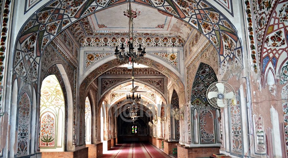
Mahabat Khan Mosque, Peshawar The Mahabat Khan Mosque (Mohabbat Khan Masjid) is located to the west of Chowk Yadgar in Peshawar, Khyber Pakhtoonkhwa, Pakistan. It was constructed in the 17th century during the Mughal era, specifically in 1630. As the largest mosque in Peshawar, it is nestled within the historic boundaries of the city, commonly referred to as the “Ander Shehr” (Inner city). This majestic structure pays homage to Nawab Mahabat Khan, a prominent Mughal governor of Peshawar who served twice under the Mughal Emperors Shah Jehan and Aurangzeb. His lineage traces back to Nawab Dadan Khan, a former governor of Lahore. The mosque’s stunning white marble façade is celebrated as one of Peshawar’s most iconic landmarks. Mahabat Khan Mosque today is a hub for prayers and social gatherings as well as serves as a tourist attraction. Peshawar City Peshawar, nestled in a valley near the eastern terminus of the storied Khyber Pass and adjacent to the Afghanistan border, boasts a rich history that stretches back to at least 539 BCE. This makes it not only Pakistan’s oldest city but also one of the most ancient in all of South Asia. In antiquity, Peshawar served as the capital of the illustrious Kushan Empire, a realm renowned for its prosperity and cultural efflorescence. It was during this period that the city reached the zenith of its splendor, boasting magnificent architectural marvels, bustling markets, and a vibrant multicultural milieu. One such testament to the grandeur of ancient Peshawar is the Kanishka Stupa, a monumental edifice that is believed to have rivaled the tallest structures of its time. Throughout the centuries, Peshawar has played a pivotal role in shaping the cultural, political, and economic landscape of the region. History of Mahabat Khan Mosque The Mahabat Khan Mosque was constructed between 1660 and 1670 during the Mughal period. It is positioned atop the highest point in the old city. Interestingly, during the Sikh era, the minarets of the mosque were utilized for hanging prisoners. It was a grim practice where five individuals were hanged daily from these minarets, serving as makeshift gallows. Additionally, in the aftermath of the Soviet invasion of Afghanistan, the mosque became a gathering place for refugee tribal elders. Their aim was to foster unity among Afghans in resistance against the Soviet forces. Legacy and Heritage of the Mosque Nawab Mahabat Khan’s legacy echoes through the corridors of this majestic mosque. As a distinguished Mughal governor, his influence extended far and wide, shaping the cultural landscape of Peshawar. The mosque stands as a tribute to his illustrious lineage, commemorating his contributions to the city’s splendor. Architecture and Design of the Mosque  Layout The Mahabat Khan Mosque undoubtedly stands out as a hidden treasure in Peshawar. It is nestled among various other heritage landmarks of the city. This architectural masterpiece radiates both beauty and historical importance. Covering an impressive area of 30,155 square feet, the mosque features a magnificent prayer hall rectangular in shape occupying the western side. In the expansive courtyard, a tranquil blue-tiled ablution pool sits at the center, surrounded by a row of rooms along the perimeter walls. Rooftop The hall is adorned with three graceful fluted domes. The roofline of the mosque ascends gradually from the outer edges towards the center, accentuated by a series of four small incremental height increases and embellished with numerous merlons. The top of the mosque’s white marble façade is adorned with cavettos or concave moldings. Additionally, atop the main entrance stand six intricately designed miniature minarets, flanked by two towering minarets. Exterior Five arched entrances lead into the main prayer hall of the mosque. The central arch, tallest among them, displays cusped arches typical of Mughal architecture. Flanking this central arch are two slightly shorter arches designed in the Persian and Central Asian styles, while smaller arches, adorned in a similar fashion, accompany each side. Above the tip of each arch, a row of seven small arched portals is observed. The three central arched portals are adorned with muqarnas, while the outermost arches feature Ghalib kari, a decorative network of ribs made of stucco and plaster. Additionally, the upper curves of the archways are embellished with vegetal motifs, showcasing a variety of colors unlike the predominantly green motifs seen at the Badshahi Mosque. Meanwhile, outside, the exquisite craftsmanship of white marble is on display. Interior The prayer hall’s interior is sheltered by three low, fluted domes, adorned with lavish and colorful paintings. Within the mosque, captivating floral and geometric designs adorn the ceiling, enhanced by graceful red frescoes. Elaborate Islamic calligraphy in a baroque style embellishes the walls of the prayer hall, while a beautiful carpet covers the floor. The calligraphy, executed in the Arabic alphabet, adds to the artistic allure of the space. Traditional chandeliers hang from the ceilings, casting a warm glow throughout. Both the interior and exterior are adorned with panels featuring intricate floral motifs and excerpts from the Quran, further enhancing the mosque’s aesthetic appeal and spiritual ambiance. Cultural Significance Throughout its storied history, the Mahabat Khan Mosque has served as more than just a place of worship. It has been a symbol of resilience and unity, welcoming refugees and fostering a sense of community during tumultuous times. Today, it continues to stand as a beacon of hope and harmony for all who seek solace within its hallowed halls. A Premier Tourist Attraction This mosque stands as undoubtedly one of Peshawar’s most renowned tourist landmarks. It is a must-visit for travelers, particularly foreign visitors exploring Peshawar. Surrounded by other prominent tourist sites, the mosque draws a significant number of visitors. At any given time, approximately 14 thousand individuals can pray within the mosque’s iconic premises and its adjoining courtyard. Access to the Mosque To reach this mosque, head to the Old Bazaar in Peshawar’s historic old city, where locals will happily guide you. From there, take Kachahry Road to Chowk Yadgar, park your vehicle, and proceed west into the Bazaar. The mosque awaits you at the street’s highest

Chaukandi Tombs
Heritage Sites in Pakistan, Islamic Heritage, Monuments, Sindh, Tombs, World Heritage Sites

Chaukandi Tombs

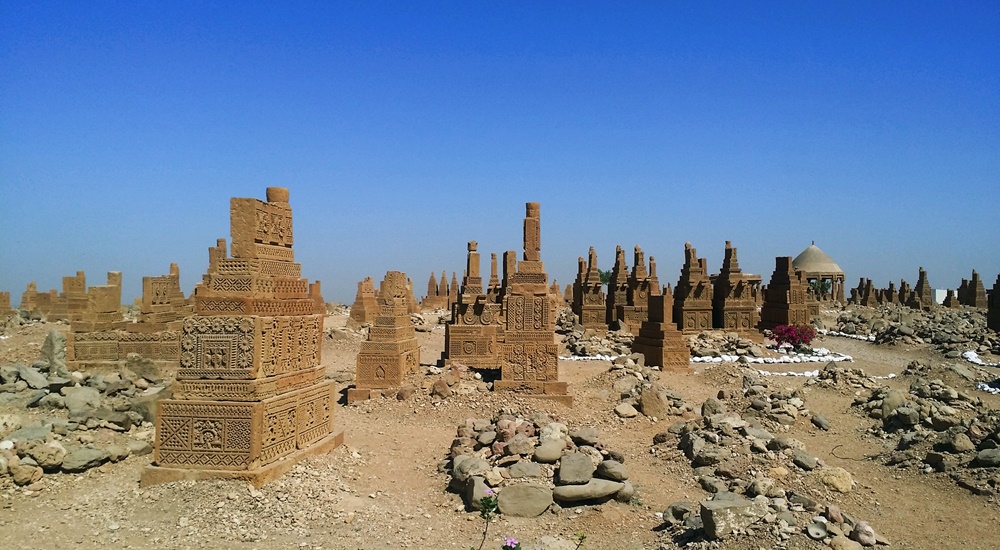
Expanding across a two-square-mile area, the Chaukandi Tombs near Karachi form an ancient Islamic burial site. The Chaukandi Tombs are renowned for its detailed sandstone carvings. These tombs bear a stylistic similarity to the elaborate graves located at the Makli Necropolis, one of the six UNESCO World Heritage Sites, near Thatta. Displaying the distinctive funerary architectural style typical of lower Sindh, the Chaukhandi Tombs undoubtedly provide a fascinating insight into the historical and artistic legacy of the region. History of Chaukandi Tombs: The Chaukhandi graveyard is attributed to the Jokhio tribe of Sindh. At the same time, other Sindhi tribes like Burfat, Jakhra, and Shaikh tombs are also found. The graveyard was constructed during the Mughal rule from the 15th to the 18th century, a period dominated by Islam. In addition to the Jokhio tribe, various Baloch tribes with Rajput origins have found their final resting place here. The influence of the Rajput tribe is evident in the design of the tombs. The step-shaped graves basically showcase a blend of cultures. For instance, some graves feature Rajput characteristics like monumental pedestals and slabs, while others exhibit simpler decorations, resembling a child’s drawing of a human face. Likewise, some tombs lack any human figures, reflecting Islamic beliefs and contributing to the diverse historical tapestry preserved in the Chaukhandi necropolis. The majority of the tombs at Chaukhandi especially represent family graveyards. However, only a limited number placed beneath pillar canopies that exhibit a Hindu architectural style. On certain male graves, intricate carvings depict a horseman equipped with arms such as a shield, sword, bow, and arrow. Meanwhile, carvings on women’s graves portray ornamental details like bracelets, necklaces, rings, anklets, and more. Additionally, for male graves, a boss-shaped projection at the northern end is designed to secure the turban of the deceased. These detailed carvings provide insights into the cultural and personal attributes of the individuals interred at Chaukhandi. Design of Chaukandi Tombs: The tombs at Chaukhandi stand out as a distinctive illustration of surface burials. Unusually aligned from south to north, a departure from the norm in both the region and period, these tombs are crafted from substantial sandstone slabs intricately arranged to form refined pyramid shapes. The meticulous carving on these slabs showcases intricate patterns, drawings, and scenes that contribute to the unique artistic and historical significance of the Chaukhandi Tombs. The absence of precise dating inscriptions on the Chaukhandi Tombs makes it challenging to determine their exact historical timelines. A typical casket consists of six vertical slabs, with two placed at the head and foot of the grave and the remaining four covering the sides, accommodating the length of the body. The tomb takes on a pyramid-like shape, featuring six large slabs covered by another tomb comprising six smaller vertical slabs. The architecture of Chaukandi Tombs: These tombs explicitly represent a unique blend of Sindhi and Balochi architectural styles. Crafted from beige-colored sandstone, these tombs come in the form of single graves or clusters, containing up to eight tombs. Despite the challenges posed by the region’s arid climate, these tombs have endured, serving as a resilient testament to the culture and heritage of the area. Chaukhandi Tombs, a form of funerary architecture, are characterized by square-shaped structures. Its five horizontal slabs enclosing the upper part of the tomb. Notably, these structures often exhibit a carved knob resembling a crown or turban at the front. Graves of warriors from the tribe boast intricate designs and motifs, including depictions of horsemen, jewelry, and hunting scenes. In contrast, tombs of women showcase carvings of anklets, bracelets, and jewelry at the front rather than human figures. Men’s graves typically feature carvings of swords, symbolizing their role as protectors of the tribe during times of war. Distinctive Features of Chaukandi Tombs: The Chaukhandi Tombs exhibit several distinctive features: The most prominent visual characteristic of Chaukhandi tombs is their cone-shaped roofs, constructed using bricks or stones and mortar. This design choice was made to distribute the weight of the structure over a larger area, enhancing stability and durability. The walls of Chaukhandi tombs are built in a beehive formation. The tombs feature multiple layers of stones arranged in a stepped pyramid shape. Constructed from local stones and bricks, these walls often bear decorative designs. Inside each tomb, there is typically a dedicated prayer chamber. This space actually serves for mourning and remembrance of the departed. Accompanying every tomb is a raised grave platform, situated above the surrounding landscape. This platform serves as a place for the family of the deceased to conduct rituals related to the burial. Discovery of Chaukandi Tombs: The Chaukhandi Tombs gained historical recognition with the earliest reference found in a letter written by J. Macleod, a Scottish historian, to Sir Henry Bartle Edward Frere, a British administrator, in 1851. However, it was H. D. Baskerville, the Assistant Collector of Thatta in Karachi in 1917, who brought these historical graves into prominence. In 1922, the site was officially included in the Ancient Monuments Preservation Act. Jean Philippe Vogel, a distinguished Dutch epigraphist employed by the Archaeological Survey of India from 1901 to 1914, played a crucial role in shedding light on the tombs. His extensive research revealed that many of these tombs belonged to Muslims. It was evident from the Arab script inscribed on their graves. Vogel’s findings provided valuable historical insights into the religious heritage of India. Post-independence, scholars and historians continued their in-depth investigations into the Chaukhandi Tombs. Rubbings of these tombs were displayed globally, capturing the attention of academics and sparking further research into this significant archaeological site. Recommendations: Chaukhandi Tombs are highly recommended to visit for individuals passionate about archaeology and history. The site holds a wealth of historical narratives. If you’re intrigued, plan your visit to this amazing site. Apart from the rich decoration adorning the tombs, another noteworthy aspect shared with similar necropolises worldwide is the prevalent local belief that the area is haunted. The Chaukhandi Tombs are reputed to be one of the most haunted sites in the

Tentative list of UNESCO World Heritage Sites of Pakistan
Blogs, Heritage Sites in Pakistan, World Heritage Sites

Tentative List of UNESCO World Heritage Sites of Pakistan

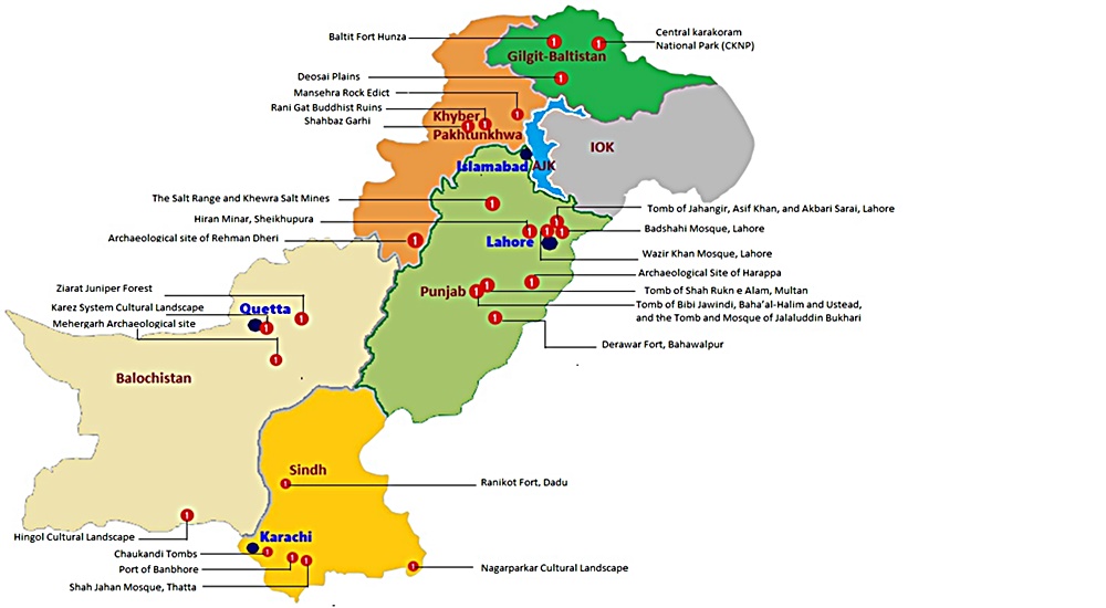
Tentative List of UNESCO World Heritage Sites of Pakistan Pakistan boasts six UNESCO World Heritage Sites. In addition to these established sites, the country has compiled a roster of 25 potential sites called the Tentative List of UNESCO World Heritage Sites of Pakistan seeking recognition. This catalog has been formally presented to the UNESCO Committee for assessment and approval. The pre-listing process is a mandatory step for the eventual acceptance of nominations onto the esteemed World Heritage list. Punjab Province The Salt Range and Khewra Salt Mine The Salt Range, rising abruptly from the Punjab plains in Pakistan, spans 180 km and features sheer escarpments, jagged peaks, and fertile valleys. Originating 800 million years ago, it formed from the evaporation of a shallow sea and underthrusting of the Indian Plate. Named for the thickest rock salt seams globally, the range is a geological treasure with fossiliferous stratified rocks and exposed strata, attracting global geologists. The region is rich in paleontological finds, including dinosaur trackways, Cretaceous belemnites, and ancient hominid remains. The Salt Range is a historical and cultural hub with sites dating from Alexander the Great‘s era to the British colonial period. Notably, Khewra hosts one of the world’s richest salt deposits, exploited for over a millennium, continuing as a mining, research, and tourism center. Badshahi Mosque, Lahore The Badshahi Mosque and its expansive courtyard are elevated on a platform accessible from the east via a grand staircase and a traditional Mughal-style gateway. The entrance, a two-story structure, boasts intricate decorations with framed and carved paneling on all facades. Square minarets with pseudo-pavilions in red sandstone and white marble cupolas adorn the four corners. Its tall octagonal minarets are positioned at the courtyard’s corners. Additionally, smaller octagonal minarets are attached to the prayer chamber’s corners, beneath three grand marble domes. The red sandstone exterior is subtly adorned with white marble inlay lines and patterns. The interior and exterior of the prayer chamber feature unique and beautifully crafted Zanjira interlacing and floral motifs in bold relief, showcasing unparalleled beauty and craftsmanship in Mughal architecture. The gateway’s inscription indicates its construction in A.H. 1084 (1673-74 A.D.). Wazir Khan Mosque, Lahore The Wazir Khan Mosque, covering an area of 279′ x 159′, is entirely constructed using cut and dressed bricks laid in kankar lime, with minimal use of red sandstone in the gate and transept. The courtyard is split into two sections, with the upper part slightly elevated and an ablution tank in the middle. Flanking the east, north, and south sides of the courtyard are 32 small hujras of varying sizes. The prayer chamber on the west side features five compartments divided by massive piers supporting wide, four-centered arches, each topped with a dome. Small rooms are created at the northern and southern ends, and an eastern gallery leads to a spiral staircase accessing the roof. Distinctive structural elements include four corner minarets, five domes, and a transept at the entrance gate on the east. According to inscriptions, the mosque was built in A.H. Archaeological Site of Harappa The archaeological site of Harappa, extending over 150 hectares, comprises eight mounds and two cemeteries situated to the south of the dry Ravi riverbed. While much of the site is buried beneath agricultural land or the modern village of Harappa, exposed structures on mounds AB and F date back to the third millennium BC. The site’s sequence spans from the fourth to the second millennium BC, with a depth of over 13 meters. The strategic location beside the old course of the Ravi River granted inhabitants access to trade networks, aquatic resources, and water for cultivation, explaining its prolonged occupation. Harappa’s town plan during the mature Harappan period (2600-1900 BC) features self-contained walled centers on raised mounds. The site’s unique urbanization declined in the second millennium BC, and subsequent developments, including brick removal for railway ballast in the 1850s and salination from irrigation agriculture, impacted the preservation of structures. Tombs of Jahangir, Asif Khan and Akbari Sarai, Lahore The Tombs of Jahangir, Asif Khan, and Akbari Sarai, designated on December 14, 1993, showcase remarkable Mughal architecture. Jahangir’s Tomb is a single-story structure with a square plan, featuring tall octagonal corner towers and a projecting entrance bay on each side. The exterior boasts red sandstone facing with intricate marble inlay decoration. The interior displays floral frescoes, delicate inlay work (pietra dura), and vibrant marble intersia. Asif Khan’s Tomb, an octagonal structure with a high bulbous dome, stands in a vast garden. Originally adorned with rich stone inlay and bold stucco tracery inside, it featured a high bulbous double dome covered with marble veneering. Akbari Sarai, between Jahangir and Asif Khan’s, includes an open courtyard with small cells, adorned gateways, and a mosque with three splendid domes. The Sarai and the entrance gateway seem part of a unified complex from Shah Jahan’s era, sharing similar styles and elements. Hiran Minar and Tank, Sheikhupura The Hiran Minar, erected under Emperor Jahangir’s reign in 1620 AD, boasts unique architectural elements. Its facade sports 210 square perforations arranged in 14 rows, while inside, a spiral staircase with 108 steps leads to the top, adorned with 11 rectangular arched openings. Divided into six tiers, the Minar showcases lime plaster possibly embellished with floral or linear frescoes. An arched entrance graces the lowest tier. Across from it lies a rectangular tank connected by a causeway to an octagonal baradari. Each corner features square pavilions with gateways. The tank, equipped with ramps, parapet walls, and staircases, connects to the Aik rivulet via a channel. Inside the baradari, intricately decorated niches and honeycomb patterns adorn the walls. The causeway, supported by 21 pointed arched pillars, links the main baradari to an octagonal platform in the tank’s center, which served as a royal residence. Tomb of Hazrat Rukn-e-Alam, Multan The tomb of Shah Rukn-i-Alam, constructed between 1320 and 1324 AD by the Tughluq ruler Ghiyas-ud-din, was initially meant for his dynasty but later dedicated to the family of the revered Sufi saint. This

Kot Diji Fort
Forts, Islamic Heritage, Monuments, Sindh

Kot Diji Fort

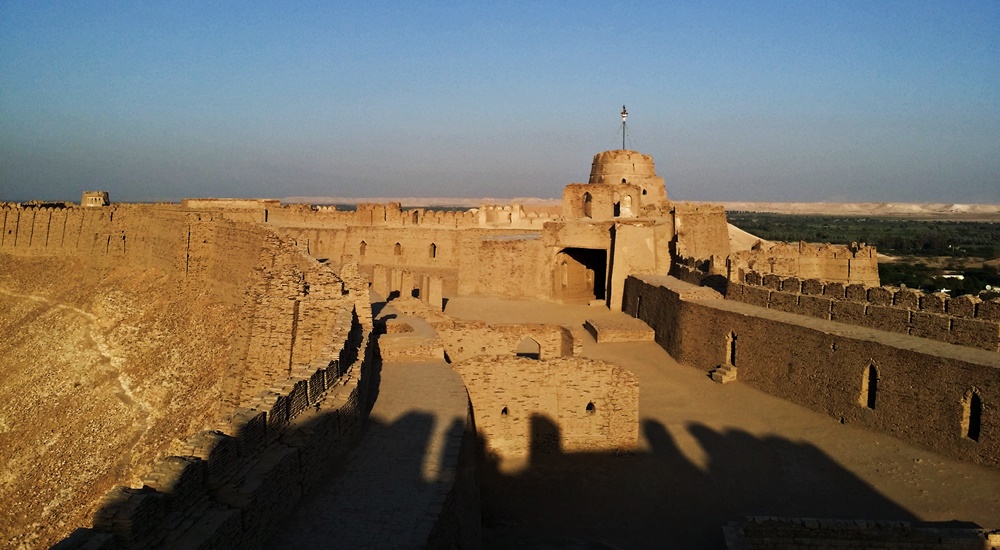
The Khairpur district in the Sindh province is renowned for housing several remarkable monuments showcasing architectural marvels, and one of them is the Kot Diji Fort from the Talpur Era. This historical edifice’s structure remains standing, preserving its grandeur for visitors to admire. The name “Kot Diji Fort” is derived from the Sindhi language phrase “Diji jo Qilo,” which translates to “Fort of the Daughter.” History of Kot Diji Fort The history of Kot Diji Fort reveals its significance during the Talpur Era in the Khairpur district of Sindh. The fort was divided into three parts among the Talpurs, with each portion falling under the control of different Talpur rulers. Mir Sohrab Khan was the first Talpur ruler of Khairpur Mirs and founder of the Kingdom of Upper Sindh. He played a crucial role in fortifying the frontiers of his rule. Among the forts he commissioned, Kot Diji Fort stands out as an architectural marvel. Mir Sohrab Khan constructed Kot Diji Fort in the capital town of Kotdiji, making it his residence a few years before his death. The fort was eventually handed over to his sons. Notably, in January 1843, during the military campaign led by Charles Napier to conquer Imam Garh, British troops also stayed at Kot Diji Fort. What adds to the historical significance of Kot Diji Fort is its location on the archaeological site of the pre-Harappan civilization, dating back to 2500-3000 BC. This unique aspect, combined with its association with Mir Sohrab Khan and the British military presence, makes Kot Diji Fort a prominent tourist attraction in Sindh. The fort stands as a testament to the rich historical and archaeological heritage of the region. Construction The construction of the remarkable historical monument in Sindh, Kot Diji Fort, spanned a decade, taking place from 1785 to 1795. Initially named “Fort Ahmadabad,” the fort derived its name from Ahmad, a Persian architect. He was credited with designing and engineering its praiseworthy architecture. Strategically located on an elevated landform, the fort was purposefully designed for warfare, enabling a vantage point to monitor potential threats. The fort is enclosed by a 30-foot tall wall, encompassing the uppermost section and resulting in a narrow-width fortress with a perimeter spanning 1.8 kilometers. Three towers, each standing at a height of 50 feet, grace the fort, contributing to its imposing structure. Kot Diji Fort includes various features such as cannon placements, water reservoirs, prisons, courtrooms, ammunition storage, and a small regal residence. The combination of architectural elements and strategic positioning highlights the fort’s historical significance and its role in safeguarding the region during its era of construction. Architecture The Kot Diji Fort is situated on a limestone hill at an elevation of 110 feet. It boasts a construction using kiln-baked bricks. Positioned on the southern end of Rohri Hills, the fort’s choice of bricks, rather than limestone rocks, was likely due to their local availability and the belief that limestone would easily shatter upon impact with cannonballs during a potential attack. Built during a time when cannons were prevalent, the fort’s design incorporates several stations for cannons. Its elevated position on a narrow ridge posed a challenge for enemy cannons, requiring them to fire from a considerable distance with limited accuracy. This strategic advantage meant cannonballs could either hit the hill or overshoot the fort. It would potentially endanger the enemy forces on the other side. Main Entrance The fort’s main entrance is known as the “Shahi Darwaza” or Royal Gate. It stands 13 feet high and 10 feet wide, constructed with wood and reinforced with 234 heavy iron spikes. This engineering feat aimed to prevent any attempts to break open the gate using a heavy contingent of elephants. The gate is situated in the western corner of the northern wall and serves as the sole entrance to the fort. Additionally, three secret passages were incorporated for emergency use. Upon entering through the curved gate, visitors find themselves in a small courtyard guarded by two bastions. It is strategically positioned for fortification and defense. The fort features three towers and multiple designated areas for cannon placements. Specialized zones include roofless rooms called “Barood Khano,” intended for storing ammunition. Other notable features within the fort include heavy bastions, towers, an ammunition depot, a water reservoir, the Mirs’ harem, a prison, a court, and cells for guards and sepoys. Design The fort, designed exclusively for defense, has never faced an attack throughout its history. Its architecture emphasizes simplicity, making it a unique and captivating historical site in Sindh. Fifty strategically placed bastions, such as “Fateh Thul” (Victory Tower), were named to identify their location and purpose, featuring small and large cannons to monitor enemy movements. Rooms Specialized rooms within the fort served specific functions, such as food storage and a lamp godown. A sandstone-made “Pavilion” stands out as a fascinating feature, adorned with beautifully carved arches and platforms. This structure was historically used by the ruler for court sessions. Moreover, it was also used for issuing important orders on significant occasions, adding to the fort’s historical charm and significance. Current Status After the British invasion, the administrative offices of Kotdiji Fort were relocated to Khairpur. The decision certainly led to a gradual decline in the fort’s importance. Subsequently, the fort was repurposed into a central prison, housing notorious criminals from the area and neighboring states. In 1955, following the merger of Khairpur state with Pakistan, the last ruler, Mir Ali Murad Khan Talpur II, handed over the fort to the government. With the 18th Constitutional amendment, the fort came under the custody of the Government of Sindh. Despite its historical significance, portions of the fort are reportedly under the control of influential local families. The government of Pakistan has recognized Kot Diji Fort as a protected heritage site, emphasizing its cultural and historical value. The fort, located in Kot Diji in the Khairpur District of Sindh province, offers breathtaking views with its picturesque landscape and high boundary walls. The scenic beauty of the

The Kalash Valley
Khyber Pakhtunkhwa, Others, Tourists Destinations in Pakistan

The Kalash Valley

The Enigmatic Beauty of the Kalash Valley Nestled in the Hindu Kush mountain range within Chitral, The Kalash Valley is renowned for its distinct charm and cultural richness. Inhabiting this picturesque region are the Kalash people, a community with a unique culture, language, and a distinctive form of ancient Hinduism. In fact, one of the distinguishing features of the Kalash Valley is its cultural diversity. The Kalash people have undoubtedly preserved their ancient traditions and rituals, making their lifestyle a subject of fascination. Their festivals, folklore, and vibrant ceremonies contribute to the valley’s unique atmosphere. The entire Kalash Valley comprises three primary valleys—Bumburet, Rumbur, and Birir. Each of these valleys is embraced by the untamed Kunar River. Positioned at an elevation surpassing 6,500 feet above sea level, the valley’s rugged terrain showcases steep slopes, narrow gorges, and rocky landscapes, creating a breathtaking backdrop. As such, the Kalasha Valleys are a source of attraction for Pakistani as well as International tourists. The three Kalash valleys Bumburet Valley The Bumburet Valley is the largest, most picturesque, and most populous valley among the three Kalash Valleys. It is accessible via a road from Ayun in the Kunar Valley. This valley reaches an elevation of 1,640 meters (5,380 ft) where it meets the Rumbur Valley. Further downstream, it joins the Kunar Valley at the village of Ayun, situated at 1,400 meters (4,600 ft) and approximately 20 kilometers (12 mi) south of Chitral. To the west, Bumburet Valley ascends to a pass connecting to Afghanistan’s Nuristan Province at about 4,500 meters (14,800 ft). Despite its scenic beauty, the population in the region is facing a rapid decline. The most famous and frequently visited among the three valleys is Bumburate, located 36 kilometers from the main city of Chitral. Rumbur Valley The Rumbur Valley is a side valley situated to the north of Bumburet, approximately 32 kilometers from Chitral. It is the third and least populated of the Kalash Valleys. Birir Valley The Birir Valley, also known as Biriu, is a side valley of the Kunar Valley positioned south of Bumburet, located about 34 kilometers from Chitral. The Birir Valley is one of the oldest settlements of the Kalash tribe and has retained its authenticity in terms of architecture and local customs. The houses, streets, and pavements in Birir Valley are constructed from stones and wood, reflecting the traditional practices followed by the locals. History The Kalash valleys in Chitral boast a rich history. One of the major highlights is the presence of the Kafir-Kalash, also known as the “Wearers of the Black Robe.” This primitive pagan tribe adds a unique cultural dimension to the region. However, the origins of the Kalash people are shrouded in mystery and subject to controversy. Numerous myths surround the ancestry of the Kalash people, with one prevailing legend suggesting a connection to Alexander the Great’s army. According to this tale, five soldiers from the legions of Alexander of Macedon settled in Chitral and are believed to be the forebears of the Kafir-Kalash. This myth weaves a historical link between the ancient Greek conqueror and the Kalash people. Another intriguing narrative revolves around the migration of the Kalash ancestors to Chitral from the land of Tsiyam. The original homeland of the Kalash people, referred to in their folk songs, is believed to be Tsiyam. The details of this migration and the cultural elements retained by the Kalash people from their ancestral land contribute to the richness of their heritage. Overall, the history of the Kalash valleys is intertwined with these captivating myths and legends. Subsequently, it creates an aura of mystery and fascination surrounding the origins of the Kafir-Kalash. Religion The Kalash people, who inhabit the remote Kalash Valley in Pakistan, follow a distinctive and ancient polytheistic religion known as the Kalash religion. Rooted in animism and nature worship, their belief system revolves around a pantheon of gods and goddesses. Central to the Kalash religious practices is the veneration of various deities, with Dezau being the supreme God and Maha Devi serving as his consort. These divine figures are believed to govern different facets of life, including fertility, harvests, and protection. The Kalash people hold nature in high regard, assigning spiritual significance to mountains, rivers, and trees. Religious rituals and ceremonies are integral components of the Kalash cultural identity. The community’s festivals are marked by joyous celebrations, featuring music, dance, and feasting. These events serve as occasions for the Kalash people to express gratitude to their deities, seek blessings, and ensure the prosperity of their community. Preserving their religious traditions is of utmost importance to the Kalash people. Particularly, as their way of life encounters challenges in the face of a changing world. Efforts are underway to safeguard their unique beliefs and cultural heritage, highlighting the significance of the Kalash religion as a captivating aspect of this vibrant and distinct community. Culture The culture of the Kalash people stands out as unique and distinct, differing significantly from the many contemporary Muslim ethnic groups in northwestern Pakistan that surround them. Nature assumes a highly significant and spiritual role in their daily lives, and as part of their religious tradition, they conduct sacrifices and hold festivals to express gratitude for the abundant resources of their three valleys. The mythology and folklore of the Kalash people have been likened to that of ancient Greece, although a closer parallel can be drawn to Vedic mythology. This cultural richness, drawing from ancient traditions and beliefs, adds a layer of fascination for observers and anthropologists. The Kalash people’s unique cultural practices have captivated anthropologists, particularly in contrast to the predominant cultures in the surrounding region. The celebration of nature, the religious rituals, and the preservation of ancient mythological narratives contribute to the distinctive cultural tapestry of the Kalash people. Their way of life serves as a testament to the diversity that exists within the broader cultural landscape of Pakistan’s northwestern regions. People The Kalash people constitute a small religious and ethnic minority in Pakistan, enjoying legal and

Chitral Tourist Attractions
Blogs, City Breaks, Khyber Pakhtunkhwa, Tourists Destinations in Pakistan

Chitral Tourist Attractions

Chitral, a region in the Khyber Pakhtunkhwa province of Pakistan known for its natural beauty and cultural richness, offers several tourist attractions. Here are some notable places to visit in Chitral: Chitral Town Chitral Town is a bustling hub filled with vibrant markets and bazaars that provide a unique insight into the local way of life. These lively centers exhibit a diverse array of handicrafts, textiles, spices, and souvenirs, offering visitors the opportunity to fully immerse themselves in the vibrant colors and rich flavors of Chitral. Exploring the streets of the magnificent Chitral Town divulges a harmonious blend of traditional and contemporary architecture. The buildings feature intricate designs and elaborate frontages that beautifully showcase the region’s rich cultural heritage. This visual spectacle is sure to captivate architecture enthusiasts, providing a delightful journey through the town’s unique and fascinating aesthetic. Shahi Masjid The Shahi Masjid stands as a magnificent piece of architecture, constructed by Shujaul Mulk, the Mehtar of Chitral, in 1924 A.D. Shujaul Mulk, the ruler of Chitral from 1895 to 1936, left a lasting legacy in the form of this grand mosque. The building itself is a remarkable example of architectural dexterity, constructed with pure white marble and adorned with intricately engraved art. Situated on the bank of the Chitral River, adjacent to the Chitral Fort, the Shahi Masjid is not only a place of worship but also a testament to the rich customs and culture of the Chitral aristocracy. The architectural details of the mosque reflect the traditions of the region, creating a visual representation of Chitral’s cultural heritage. The Shahi Masjid stands as a significant landmark, inviting visitors to appreciate its historical and artistic significance. Chitral Fort The Chitral Fort, also known as Shahi Qila, is a historic fortification located in Chitral town, Khyber Pakhtunkhwa, Pakistan. Positioned on the banks of the Chitral River, it holds a strategic location not far from the Shahi Masjid. The fort is believed to have been initially constructed in 1774 during the reign of Mohtaram Shah Katur II and later restored in 1911 by His Highness Sir Shuja ul-Mulk. Originally serving as the barracks for the guards of the Mehtar of Chitral, the fort became the personal property of the last ruler of Chitral after the merger of Chitral State in 1969. Presently, it is occupied by the ceremonial Mehtar, Fateh-ul-Mulk Ali Nasir. Notably, the fort has undergone renovations, particularly to the old Darbar Hall and staterooms, following damages incurred during the earthquake of 2015. The Chitral Fort stands as a testament to the region’s historical significance and architectural heritage, offering visitors a glimpse into its rich past. Chitral Museum The Chitral Museum stands as a custodian of the unique culture and art of the region, preserving the heritage of ancestors for future generations. Established on July 8, 2010, the primary purpose of the museum is to safeguard Chitral’s cultural legacy for tourists and locals alike. The museum is divided into two distinct sections: the Ethnological Gallery and the Archaeological & Kalash Gallery. In the Ethnological Gallery, visitors encounter artifacts such as jewelry, instruments, and furniture from the 12th century, providing a glimpse into the lifestyle of Chitral’s ancestors. On the other hand, the Archaeological & Kalash Gallery focuses on items related to the Kalash, showcasing the cultural heritage with connections to Greek influences. Particularly noteworthy are the artifacts associated with their gods and goddesses, offering insights into the spiritual and religious practices of the Kalash people. The Chitral Museum serves as a valuable resource for those interested in exploring and understanding the rich cultural history of the region. Governor’s Cottage The Governor Cottage stands as a beautiful and graceful example of Chitrali architecture, showcasing the region’s glorious and distinctive construction style. Situated on elevated grassland, surrounded by mountains, the cottage provides a picturesque setting. On a clear day, visitors can admire the majestic Trich Mir Mountain from this location. Previously reserved, the place is now open to the general public. Inside, one can find a collection of well-preserved historical objects that offer insights into the rich history of the region. The Governor Cottage provides a unique opportunity for visitors to experience and appreciate the royal living style of the Mehtar of Chitral. It serves as a testament to the cultural and historical heritage of the area, allowing individuals to connect with the past and the architectural traditions of Chitral. Chitral Gol National Park Chitral Gol National Park, situated 5,000 meters above sea level in the Lower Chitral District, is a two-hour drive from Chitral town and spans 7,750 meters. This park is renowned for its abundant wildlife and panoramic views of valleys, glaciers, and streams. Formerly considered the private property of the Mehtar of Chitral until 1983, the park’s status has been disputed and is subject to ongoing litigation between the Mehtar’s heirs and the Government of Pakistan. The park encompasses three valleys with glaciers and springs feeding into an 18-kilometer stream flowing east into the River Chitral. Rich in cedar trees, the park provides a habitat for diverse wildlife, including the endangered Kashmir Markhor. Other notable mammals include the Siberian ibex, Snow leopard, Ladakh Urial, Himalayan black bear, Himalayan Wolf, Red fox, Eurasian otter, and Yellow-throated marten. Barmoghlasht Barmoghlasht, a renowned summer retreat in Chitral, is nestled amidst towering mountains and lush greenery, located 14.5 kilometers from Chitral town. Highlighting the area is the former Mehtar’s Summer Fort, strategically perched at an elevation exceeding 2800 meters, providing a captivating view of the city. Notably, it is the ancestral building of the Chitral royal family, adding historical significance to its charm, set amid vibrant green pastures. Accessible by a 40-minute drive from Chitral City, Barmoghlasht is especially enchanting in May and June when spring brings forth lush greenery and vibrant blooms. The resort offers an array of activities, making it an ideal destination for paragliding, hiking, and bird watching in the summer, while also providing opportunities for skiing during the winter months. Tourists are drawn to Barmoghlasht throughout the

Scroll to Top