Attabad Lake

The Hunza Valley
Blogs, City Breaks, Gilgit-Baltistan

The Hunza Valley

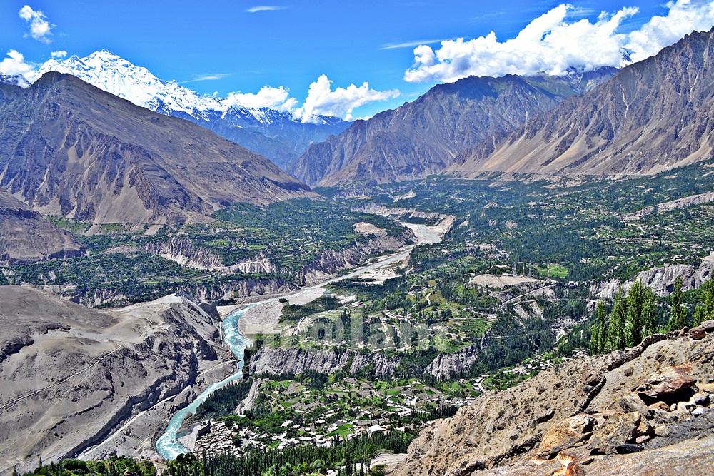
The Hunza Valley – A Place Beyond Words Welcome to The Hunza Valley, a Majestic Gem of Nature’s Grandeur – a place where nature’s beauty meets cultural heritage. Nestled in the heart of the mighty Karakoram Mountains, this remote valley is a hidden gem waiting to be explored. The words may fall short of capturing the true essence of The Hunza Valley. It is a place that needs to be experienced firsthand, where the mountains whisper ancient tales, and the valleys echo with the laughter of the locals. The serenity, the adventure, and the warmth of the people combine to create an unparalleled experience that will stay with you long after you leave. From its awe-inspiring landscapes to the warm hospitality of its people, the Hunza Valley offers a truly extraordinary experience that will leave you mesmerized. The Majestic Karakoram Range At the heart of The Hunza Valley lies the magnificent Karakoram Range. Towering peaks, snow-capped mountains, and sprawling glaciers adorn the landscape, creating a sight that will take your breath away. The Karakoram Range is home to some of the highest peaks in the world. Notable mountain peaks include K2, the second-highest mountain on earth, Broad Peak, and Gashabrum Peaks. Explore the stunning beauty of these majestic giants and immerse yourself in the grandeur of nature. Cultural Heritage and Warm Hospitality The Hunza Valley is steeped in rich cultural heritage. The local communities have preserved their traditions for centuries, and their warm hospitality will make you feel right at home. Engage with the locals, learn about their customs and traditions, and savor the flavors of their delectable cuisine. Immerse yourself in their vibrant festivals and witness the traditional dances that reflect the valley’s vibrant spirit. Traditional Music & Rituals Hunza is known for its rich cultural heritage, including traditional music and rituals. The people of Hunza have a distinct cultural identity, and their music and rituals are an integral part of their social and religious practices. Music holds a significant place in Hunza’s cultural traditions. In addition to their music, the people of Hunza have various rituals and celebrations that hold cultural and religious significance. Some of the notable rituals and celebrations include Ginani, Nasalo, Bofao, Nawruz, Salgirah of Imam e Zaman, Shab e Barat, Shab e Meraj, Eid Gadeer, Eid ul Fitr, and  Eid ul Adha. Traditional Cuisine  The valley is also famous for its delectable cuisine, featuring a variety of local dishes such as Chapshuro, Gurey Fiti, Makaye Fiti, Makaye Faqo, Burus Shapik, Giyaling, Hamao Giyaling, Hoi Lo Garma, Diram Fiti, Batering Dawdo, Buqpa Dawdo, Chap tze Dawdo, Haniye Del (Apricot Oil), Hani tze Dawdo, Hani tze Chamic (Apricot Sauce), Harisa, Sharbat, Mulida, Shopan, Chhamus,  and apricot-based desserts. The organic produce grown in the region, including cherries, apricots, and almonds, adds to the culinary delights of the valley. The Kha Basi Café on the premises of Altit Fort, Café De Hunza at Karimabad, Mulberry Hotel, Darbar Hotel, and Hidden Paradise offer a great taste of traditional food. Fruits of the Hunza Valley The journey of fruits in Hunza begins with cherries in May after the blossom season concludes in April and varieties of fresh fruits remain available until November. During winter, a variety of dry fruits and byproducts made of dry fruits are available in the market. Seasonal fruits include black, red, and white Cherries in May and June; Plum, Figs, and a variety of Apricots in June and July; Apples in July & August, a variety of grapes in August and September, Peach in September and October, and Japanese fruit in November. Outdoor Activities Exploring the Hunza Valley offers numerous outdoor activities for adventure enthusiasts. Visitors can embark on a thrilling trek to Ultar, hike up to Duikar from Karimabad or Altit, walk along the Hunza water channel or to viewpoints for panoramic vistas, go rock climbing, indulge in mountain biking, Paragliding from Duikar, or walk surrounding valleys. There are other exciting options including a trip to upper Hunza which covers the beautiful road trip to Khunjerab Pass, Rainbow Bridge Photography, a day hike towards Batura Glacier, visiting Borith Lake and walk up to the glacier, a day hike from Borith to Husseni village, Husseni Suspension Bridge crossing & Zip Line experience, hike up to Ondgra Poyga, explore Shishkat valley, boating at Attabad Lake, and visiting the magnificent Hoper Valley. The Karakoram Highway, which passes through the valley, provides an adventurous road trip experience with stunning vistas at every turn. Shopping in Hunza Karimabad, also known as Baltit, is the main bustling market with various shops, stalls, and local vendors selling a wide range of items in Hunza. Exquisite handicrafts such as carpets, rugs, embroidered textiles, traditional caps, shawls, and wooden carvings make for great souvenirs or gifts. Hunza is also famous for its gemstones and jewelry displayed in a variety of gemstone stores offering precious and semi-precious stones like turquoise, garnet, topaz, and more. Additionally, unique jewelry pieces inspired by the local culture are also seen on display. Moreover, delicious dried fruits, nuts, and apricot products including dried apricots, apricot oil, apricot jams, and apricot-based sweets like Hunza halwa. These local delicacies are a must-try and can be found in many shops. Similarly, traditional clothing such as embroidered shirts, woolen waistcoats, caps, gowns, and shawls featuring local craftsmanship and the cultural heritage of the region is easy to find in the market. Seasonal Attractions Blossoming Orchards The Hunza Valley is renowned for its vibrant orchards. As spring arrives, the valley transforms into a breathtaking paradise with the blooming of cherry, apricot, peach, and pear trees. The delicate pink and white blossoms create a picturesque scene, attracting visitors from far and wide. Take a leisurely stroll through the orchards, breathe in the sweet fragrance, and witness nature’s exquisite artistry unfold before your eyes. A Great Summer Retreat Certainly! The Hunza Valley is a breathtaking summer retreat. During the summer months, the Hunza Valley transforms into a paradise for travelers seeking respite from the scorching heat. The

The Hunza Valley Read Post »

, , , , , , , , , , , , , , , , ,
karakoram highway tourist attractions
Blogs, City Breaks, Gilgit-Baltistan, Monuments, Roads & Highways

Karakoram Highway Attractions

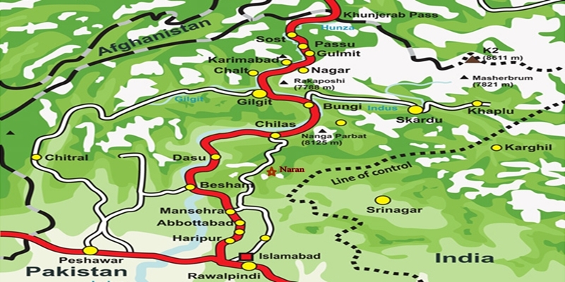
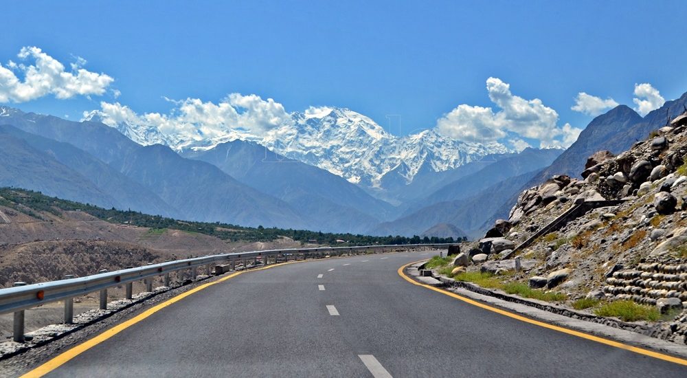
The Karakoram Highway (KKH): An Engineering Marvel  The Karakoram Highway (KKH), N-35, stands as one of the greatest wonders of the modern world. It is an awe-inspiring feat of human determination and ingenuity fondly referred to as the 8th wonder of the world. This 887-kilometer highway traverses along the Indus for 310 kilometers. Before meeting the Indus at the confluence of three mighty mountain ranges, it passes through Gilgit, Hunza, and Khunjerab. The highway runs through the Karakoram Range where 12 out of the 30 highest mountains in the world majestically overlook the KKH. Indeed, there is no other highway on earth that can rival the Karakoram Highway’s richness of attractions and breathtaking vistas. Origin and Journey of the Karakoram Highway Spanning an impressive 1300 kilometers (800 miles), the KKH commences its journey from the historic city of Hassan Abdal, approximately 45 kilometers from Islamabad on the Islamabad – Peshawar Highway. Its asphalt ribbon weaves through the cities of Abbottabad and Manshera crosses the majestic River Indus at Thakot, and continues on to Gilgit, meandering through the rugged mountains of Besham, Pattan, Sazin, and Chilas, before gracefully passing through Hunza and Sost. Finally, the highway reaches its zenith at the Khunjerab Pass, standing tall at an astonishing 4,733 meters (15,750 ft) above sea level. This pass, also known as Zero Point, marks the border between Pakistan and China. As the highway continues its journey, it enters the high Central Asian plateau and winds down through the Pamirs until it reaches Kashgar, situated at the western edge of the Taklamakan Desert. Gilgit-Baltistan is a treasure trove of history and natural wonders. It beckons travelers from all corners of the world to witness its splendor. As you explore this enchanting region, you will undoubtedly be captivated by the stories etched into its landscapes and monuments, a testament to the richness of its cultural heritage and the indomitable spirit of its people. Major Attractions along the Karakoram Highway The Karakoram Highway is undoubtedly crowned with a plethora of attractions, showcasing a harmonious blend of ancient rock carvings, awe-inspiring petroglyphs, mesmerizing natural beauty, and remarkable man-made marvels. Here are some of the major Karakoram Highway attractions that continue to captivate travelers from around the globe: The Khyber Pakhtunkhwa Section The Karakoram Highway passes through the plains, lush hills, and barren mountains of the Khyber Pakhtunkhwa before it enters the Himalayan range of Gilgit-Baltistan which boasts the height of the Karakoram Highway Attractions in the region. Mansehra Rock Edicts  Ashoka Rocks MansehraLocated on the north side of the town of Mansehra, the Ashoka Rocks bear witness to history with 14 edicts engraved by order of the Mauryan King Ashoka in the 3rd century BC. Although the Kharoshti script inscription is fading away, shelters have been built to protect this invaluable relic, making it accessible to visitors. The three granite boulders bearing 14 edicts engraved by order of the Mauryan King Ashoka in the 3rd century BC are located on the north side of the town of Mansehra. The inscription bearing Kharoshti script is fading away and almost impossible to see despite the shelters to protect it. Diamer Section: Threshold to Gilgit-Baltistan The Diamer Section runs in the rugged mountains for about 200km starting from the border between Tangir and Kohistan to Jaglot near the junction point of three great mountain ranges where Gilgit River and Indus converge. Shatial Petroglyphs A treasure trove of Buddhist archaeological wonders, the Shatial Rock Art Carvings or Petroglyphs can be found along the Karakoram Highway, previously known as the Old Silk Route. Carved into large rocks, these petroglyphs depict Jataka tales and Stupas, symbolizing the journeys of monks and pilgrims to Gandhara during the Buddhist era. Sadly, the construction of dams like the Diamer-Basha Dam and Dassu Dam has put these carvings in jeopardy, threatening their existence. Thalpan Petroglyphs The town of Chilas is surrounded by striking petroglyphs, particularly the ‘Chilas I’ site, which features inscriptions on both sides of the KKH and is considered a key Karakoram Highway Attraction spot. One of the most striking carvings here is the depiction of a large stupa with flying banners. Across the river, visitors can marvel at stones bearing art showcasing mythical animals, battle scenes, royal lineages, and Buddhist tales. Another site, ‘Chilas II,’ located near the police check post on the KKH, features a huge rock adorned with hunting and battle scenes, a Buddhist stupa, the long-horned ibex, and symbols of fertility. Nanga Parbat View The Thakot Bridge is the base point for an unforgettable journey to Fairy Meadows and the base camp of Nanga Parbat, famously known as the “Killer Mountain”. The bridge is situated approximately 78 kilometers south of Gilgit.  The Thalechi viewpoint offers travelers a perfect spot to pause and admire the sublime beauty of Nanga Parbat. Gems in Gilgit Region Gilgit is the administrative headquarters of Gilgit-Baltistan. The region is enormously blessed with historical monuments and breathtaking natural landscapes.  About 90km section of the Karakoram Highway from Jaglot to Guro (Jaglot) passes through the region. Partab Bridge The Partab Bridge is located about 40 kilometers southeast of Gilgit. It played a crucial role in connecting Gilgit with Bunji, Astore, and Kashmir long before the construction of the Karakoram Highway. Built between 1889 and 1893, this suspension bridge served as a vital communication link and facilitated trade. However, during the 1947 revolt when Gilgit gained independence from Dogra Raj, the bridge was burnt down. Despite facing decades of neglect, it was rebuilt after the 2010 floods, standing as a testament to human resilience. Junction Point of Three Great Mountain Ranges Jaglot, a mere 40 kilometers southeast of Gilgit, hosts the Junction Point of the Three Mountain Ranges. Here, the Karakoram, Himalaya, and the Hindukush converge. This unique location also marks the confluence of the Gilgit and Indus Rivers. About 5 km to the north, the Skardu road diverges from the KKH. Standing at the monument, visitors are treated to splendid views of the meeting of these three

Karakoram Highway Attractions Read Post »

, , , , , , , , , , , , , , , , , , , , , , , , , , , , , , , , , ,
Attabad Lake on the Karakoram Highway in Hunza
Gilgit-Baltistan, Lakes

Attabad Lake

Attabad Lake: A Gem on the Karakoram Highway In the heart of Hunza, nestled along the legendary Karakoram Highway, lies a breathtaking jewel known as Attabad Lake. This pristine oasis emerged from the aftermath of a massive landslide that struck on January 4, 2010. Although the catastrophe claimed lives and property, it also heralded a remarkable transformation in the region. Over time, Attabad Lake rose to fame and established itself as a premier tourist destination. It captivates the hearts of visitors from far and wide. Discovering Attabad Lake’s Location Attabad Lake is situated approximately 19 kilometers east of Karimabad in the enchanting Hunza region of Gilgit-Baltistan, Pakistan. Perched along the Karakoram Highway, the lifeline connecting China and Pakistan, this natural wonder is just a three-hour drive from Gilgit. The lake makes it easily accessible to travelers seeking its beauty. The Tale of Attabad’s Creation The lake’s name, “Attabad,” bears witness to the valley of the same name, which was devastated to give birth to this stunning waterbody. It was the peak of winter when a colossal portion of the valley tumbled into the Hunza River. The event tragically claimed the lives of 20 residents, hundreds of livestock, and valuable land and property. This monumental a-kilometer-thick mudslide resulted in blockage of the river flow upstream along the Hunza River. Over time, the obstructed river began to swell, forming a sprawling water reservoir. As a result, this reservoir submerged adjoining valleys upstream. Thus, it completely inundated Ayeenabad and engulfed 40% of the Shishkat Valley. Consequently, homes, shops, and hotels along the 19-kilometer stretch from Attabad to Hussani Village drowned. The consequences were dire with over 6,000 people displaced. Eventually, trade and travel along the Karakoram Highway were disrupted. At the same time, more than 25,000 residents in the Gojal region were affected severely. Spill Over In June 2010, approximately five months after the initial landslide, the Hunza River began to spill over the barrier. Swift action was taken with the assistance of the Frontier Works Organization (FWO) of the Pakistan Army to create an immediate spillway, reducing the water level. At that time, the lake stretched to a length of 21 kilometers with a depth of about 358 feet. As the waters receded, hope blossomed for the affected residents, revealing their land and property once more. This catastrophic event disrupted communication systems, leaving the region’s people stranded for several months. The local business community suffered greatly. Likewise, tourists faced significant challenges during harsh winter conditions. Particularly, navigating the treacherous currents while traveling on open ferries or on foot was not an easy task. For the region’s inhabitants, most of whom relied on selling local produce like crops, fresh fruit, and dry fruit, the disaster was twofold. Their productive land was lost, and the remaining produce couldn’t reach the market in a timely manner, resulting in substantial financial losses. Rebuilding and Development In the immediate aftermath, the National Disaster Management Authority (NDMA) provided helicopter services to address the emergency, but this solution was not sustainable. Instead, manual boats were introduced, serving the community until the Karakoram Highway connection was restored in August 2015 through the construction of five long tunnels, overcoming the solid rock obstacles. The introduction of speedboats catered to tourists, and local residents established various camping sites along the lake’s banks. Each passing year brought new developments, enhancing the experience for tourists and allowing them to make the most of their visit. Attraction: Attabad Lake Today Today, Attabad Lake stands as a favored tourist destination. It’s a 14-kilometer stretch of the Karakoram Highway that runs parallel to its shimmering waters. Travelers can revel in its multi-dimensional beauty from well-organized viewpoints along the highway, marveling at the deep blue waters framed by rugged mountains and lush valleys. The journey features a series of lengthy tunnels, picturesque bridges, and opportunities for water sports. famous ones include jet skiing, speedboats, and ferries providing every passerby with a joyous experience. Local residents have embarked on the path of recovery, rebuilding their homes and businesses. Substantial investments are pouring into new infrastructure projects, all aimed at attracting and accommodating tourists. Beyond the lake’s serenity, the surrounding vistas, including the iconic Passu Cones, offer captivating sights. Meanwhile, views of the lake from the surrounding valleys and mountains are nothing short of breathtaking. Accessible year-round via the main Karakoram Highway, Attabad Lake continues to evolve. With each passing year, new developments further enhance its allure. Consequently, it draws in more tourists than ever before. Whether you seek natural beauty, adventure, or tranquility, Attabad Lake has it all. New developments make it a must-visit destination for travelers from around the globe.

Attabad Lake Read Post »

, , , , ,
The Karakoram Highway
Blogs, Gilgit-Baltistan, Roads & Highways

The Karakoram Highway

Exploring the Karakoram Highway: A Journey Through History and Scenic Beauty The Karakoram Highway (KKH) stands as a testament to human determination and engineering feats. It connects China and Pakistan via the Khunjerab Pass, situated at an awe-inspiring altitude of 4,733 meters. This epic roadway is not just a trade artery but also a legendary tourist attraction. It offers a captivating blend of historic landmarks, cultural diversity, and breathtaking natural beauty. For adventure enthusiasts, embarking on a journey along the KKH is an absolute thrill. Traversing Pakistan’s Section: A Scenic Odyssey The KKH adventure begins in Hasanabdal, Punjab, Pakistan. It stretches across an impressive 887 kilometers until it reaches the Khunjerab Pass at the Pak-China border. Along this route, the highway meanders through the rugged terrain of Khyber Pakhtunkhwa (KPK). It then follows the course of the Indus River and gracefully navigates the Karakoram and Pamir Mountains. Eventually, it meets the Chinese segment at Khunjerab Pass. In China, this remarkable highway is known as the Friendship Highway. Due to the harsh conditions it was built, it is sometimes referred to as the “Eighth Wonder of the World.” Unveiling the Route: A Glimpse into the Length The total length of the Karakoram Highway spans approximately 1,300 kilometers, with 887 kilometers in Pakistan and 413 kilometers in China. While the new route doesn’t exactly replicate the ancient Silk Route, it closely follows the same region, reviving the spirit of this historic trade network. The construction of the KKH came at a significant human cost, with both Pakistani and Chinese laborers toiling relentlessly to complete each kilometer of this ambitious project. Chinese workers who lost their lives during construction are honored at the Chinese cemetery, China Yadgar, in Danyore near Gilgit. Historic Roots: A Glimpse into the Past Historically, the Karakoram Highway was a vital caravan trail, serving as one of the branches of the ancient Silk Route. Over centuries, traders, pilgrims, warriors, and common folk traversed this route, ushering in profound changes in the social, cultural, and economic aspects of the region. The Saga of Construction: Overcoming Challenges Before the Karakoram Highway was built, the northern areas, now known as Gilgit-Baltistan, attracted the interest of the Russians, Chinese, and British, owing to its strategic significance. However, access to the region was a formidable challenge. In the 1800s, the British, who were in power, aimed to bolster their authority by constructing an all-weather communication infrastructure along the Indus. Realizing this vision was no small feat. Initially, the British improved an old Srinagar foot track, transforming it into a mule track. Later, a seasonal passage was established through Chilas, crossing the Babusar Pass to connect to the Kaghan Valley. Unfortunately, this passage remained open for only about six months a year during the summer. Following the partition of the subcontinent in 1947, the Srinagar road was permanently blocked. This period saw the northern areas divided into several states under local rulers. In 1958, the Indus Valley Road (IVR) project was conceived to create an all-weather road link between Swat and Gilgit. Construction commenced in 1959 as a joint venture between the two governments. Then, in 1966, a Sino-Pak agreement transformed the IVR into the Karakoram Highway. Despite financial constraints and the outbreak of the war between Pakistan and India in 1971, China’s invaluable support enabled the project to continue. Originally planned to stretch from Thakot to the Khunjerab Pass, the entrance point was later shifted to Hasan Abdal, and the project was completed in 1979. The highway was finally opened to the public in 1986. During construction, approximately 800 Pakistanis and 200 Chinese workers lost their lives, primarily due to landslides. Unofficial estimates suggest an even higher toll. The Chinese workers were laid to rest at the Chinese Graveyard in Danyore near Gilgit. A Path to Reconstruction: Upgrading the KKH In June 2006, Pakistan’s National Highway Authority (NHA) and China Road and Bridge Corporation (CRBC) signed an MoU to upgrade the KKH, expanding its overall width from 10 to 30 meters. This expansion aimed to accommodate heavy-duty vehicles, even in extreme weather conditions. Although construction took place, the width remained largely unchanged from the original design. During the construction phase, a significant event occurred on January 4, 2010, known as the Attabad incident. A massive landslide in the Attabad valley of Hunza damaged a section of the highway, creating a 23-kilometer-long lake and disrupting travel along the Karakoram Highway. To restore the road link between Pakistan and China, the construction of tunnels along a revised 24-kilometer route began in July 2012 and was completed in September 2015. This realigned route featured five tunnels and a bridge, rejuvenating the connection between the two countries. The Geopolitical Significance: A Strategic Artery The Karakoram Highway traverses a region marked by towering mountains and geological complexities, where China, Tajikistan, Afghanistan, and Pakistan converge within a 250-kilometer radius. Due to the intricate Kashmir conflict between India and Pakistan, the KKH holds strategic and military importance for these nations, especially Pakistan and China. Beyond geopolitics, the Karakoram Highway has significantly bolstered trade and tourism between Pakistan and China. The construction of the highway resulted in uplifting the living standards of the local population. The China-Pakistan Economic Corridor (CPEC) is set to bring substantial economic gains to the region, with plans to connect the Karakoram Highway to the southern port of Gwadar in Balochistan through the Chinese-aided Gwadar-Dalbandin railway, extending to Rawalpindi. Discovering Tourist Gems: Treasures Along the KKH The Karakoram Highway has earned international acclaim as a niche adventure tourism destination. Beginning in Hasan Abdal, about 50 kilometers from Rawalpindi city, this dual-carriage asphalt ribbon departs from the dusty plains of Punjab, embarking on a journey through the lower Himalayas of Hazara district. As it heads north, it winds through numerous captivating natural and historic sites, ultimately reaching the Pakistan section’s culmination at the Khunjerab border in the upper Hunza valley. This 887-kilometer stretch of the Karakoram Highway in Pakistan is a diverse tapestry of tourist attractions. From the

The Karakoram Highway Read Post »

, , , , , , , , , , , , , , ,
Scroll to Top