Hindukush

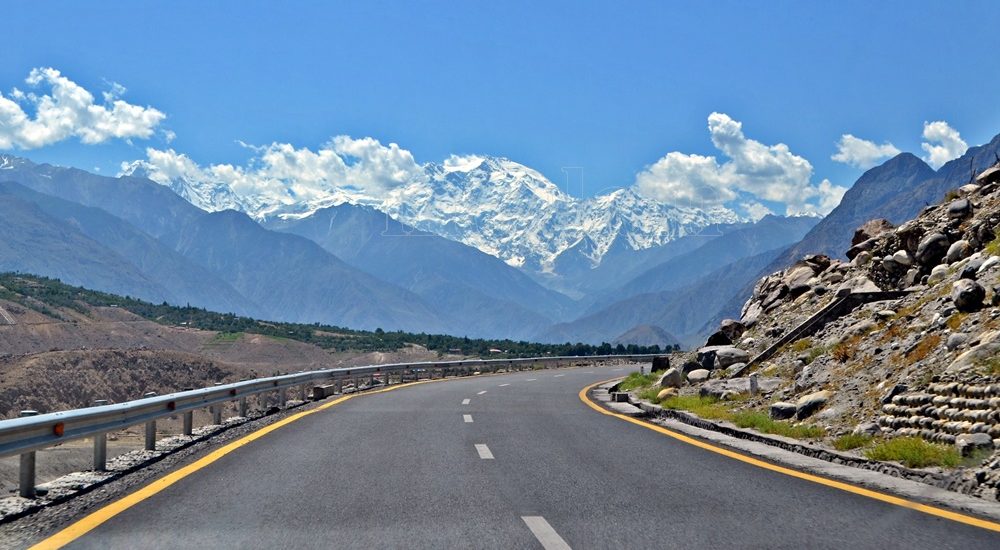
Here the great mountain ranges of the Karakoram, Hindukush, and Himalaya converge
Gilgit-Baltistan

Junction Point of Three Mountain Ranges

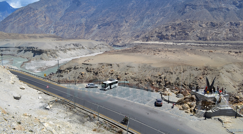
Unlocking the Secrets of the “Junction Point” of Three Majestic Mountain Ranges If you’re a true adventurer and nature enthusiast, there’s a hidden gem near Jaglot, just 40 kilometers southeast of Gilgit, Pakistan, that you absolutely must explore. It’s the awe-inspiring convergence of three of the world’s most famous mountain ranges: the Karakoram (known for its black gravel), the Himalaya (home of perpetual snow), and the Hindukush (aptly named the “killer of Hindus”). This unique location is often referred to as the “Junction Point of the world’s three great mountain ranges.” What’s more, this exceptional site also marks the meeting of the Gilgit and Indus Rivers, and the starting point of the Skardu road branching off from the Karakoram Highway (KKH). Geographic Significance: Where Worlds Collide The Junction Point isn’t just significant locally; it holds a unique place on the global stage. Pakistan is the only country where these three renowned mountain ranges converge, each boasting its highest peaks. Nanga Parbat, K-2, and Terich Mir are the standout peaks in the Himalayas, Karakoram, and Hindukush, respectively. These three ranges are considered sub-ranges of the mighty Himalayas, known as the trans-Himalayas. Standing at this point allows you to easily discern the direction of each mountain range. The Himalayan range lies to the south and east of the Indus River. The Karakoram range extends northeast from the Gilgit River, while to the west of the Gilgit and Indus Rivers, you’ll find the Hindu-Kush range. Exploring the Mountain Ranges: A Journey to Remember Karakoram Range: A World of Wonders The Karakoram Range, spanning approximately 500 kilometers, straddles the borders of Pakistan, India, and China. Within a radius of just 160 kilometers, it boasts the highest concentration of peaks soaring above 5,500 meters, numbering over 100. The crowning jewel of this range is K-2, the second-highest peak in the world, standing tall at 8,611 meters. The Karakoram is home to some of the planet’s longest glaciers, including Siachen, Batura, Baltoro, Biafo, Hisper, Gondogoro, and Chogolisa, making it one of the most heavily glaciated regions outside the Polar Regions. Himalayan Range: Nanga Parbat and Beyond The Himalayan range features Pakistan’s second-highest peak, Nanga Parbat, standing at an imposing 8,126 meters. Known as the “killer mountain” due to its formidable reputation, Nanga Parbat dominates the Astor District. The Great Himalayan Range stretches across 2,400 kilometers, encompassing Pakistan, Nepal, and India. Mount Everest, the world’s highest peak at 8,848 meters, calls Nepal home within this range. Hindu Kush Range: A Journey into History The Hindu Kush Range, spanning nearly 9,600 kilometers, is a land of its own wonders. While it primarily hosts smaller peaks, most standing below 7,500 meters, it covers the peaks of the Ghizer, Yasin, and Ishkoman valleys in Pakistan. The range reaches its zenith with Terich Mir, standing proudly at 7,708 meters in the district of Khyber Pakhtunkhwa. The Hindu Kush stretches from the Pamirs to Iran, offering a fascinating journey through history and geography. A Tourist’s Paradise: Unveiling the Junction Point A visit to this captivating site is a must for any traveler. It provides not only an educational experience but also a breathtaking panorama of the entire region, from the confluence of the Gilgit and Indus Rivers to the meeting of the three mighty mountain ranges. Local folklore weaves tales of the Junction Point being the residence of Jinns and fairies. Legend has it that these supernatural beings frequented the confluence of the rivers, using the waters for drinking and bathing. The Site: Your Gateway to Adventure An elevated platform, accessible by stairs, stands proudly on the edge of the Karakoram Highway. It offers a 360-degree view of the region and provides detailed information about the mountain coordinates. Adequate parking facilities are available for vehicles, and informative signboards offer essential information about the site. Regrettably, many, both within the country and from abroad, remain unaware of the significance of this captivating land. While some domestic tourists, particularly those traveling by public transport or passing by during odd hours or in the darkness, miss this gem, international tourists often include it as a vital stop on their itinerary. Best Time to Embark on Your Adventure The Karakoram Highway remains open year-round, allowing you to visit or pass by this unique site at any time of the year. However, the ideal time to explore Gilgit-Baltistan is from March to November, as the region’s winters can be harsh and freezing. Don’t miss the chance to stand at the crossroads of three remarkable mountain ranges, where nature’s grandeur knows no bounds. Visit Junction Point of Three Mountain Ranges, and let the magic of Pakistan’s unparalleled geography and history captivate your senses.

Junction Point of Three Mountain Ranges Read Post »

, , , , , , ,
Key Facts about Pakistan
Blogs

Pakistan

Exploring Pakistan: A Treasure Trove of Diverse Experiences Pakistan stands as an exceptional and blessed nation, graced with some of Asia’s most breathtaking landscapes. Its geography is as varied as its rich cultures, and its people are known for their warm hospitality. In the realm of discovering the roots of modern-day humanity, few places on Earth rival Pakistan. Unraveling the Tapestry of History The land that now comprises Pakistan has been a cradle of ancient civilizations and a melting pot of cultures and dynasties for centuries. From the ancient Neolithic Mehergarh civilization, dating back 9000 years, to the illustrious 5000-year-old bronze age Indus Valley Civilization, the 3000-year-old Buddhist Gandhara Civilization, the opulent Mughal Era of the 16th century, the brief Sikh rule, to over two centuries of British occupation, leading to independence in 1947, Pakistan’s history is a tapestry of unparalleled events, unlike any other sovereign state. A Glimpse of Pakistan’s Geography Officially, the country is known as the Islamic Republic of Pakistan. Most importantly, Pakistan ranks as the 6th most populous nation in South Asia. Altogether, the country houses over 224 million people from diverse cultural and ethnic backgrounds. Encompassing 881,913 square kilometers (340,509 square miles), Pakistan boasts four provinces – Sindh, Baluchistan, Punjab, and Khyber Pakhtunkhwa – and three territories – Islamabad, Kashmir, and Gilgit-Baltistan. The carefully planned capital city, Islamabad, lies at the heart of this diverse nation. Pakistan’s strategic location at the crossroads of Asia divides it into three major geographic regions: the northern highlands, the Indus River plains, and the Balochistan Plateau. Bordered by the Arabian Sea’s 1046-kilometer coastline in the south, India to the east, China to the northeast, Afghanistan to the northwest, and Iran to the southeast, Pakistan’s diverse landscape includes glaciated mountain ranges in the north (Gilgit-Baltistan), fertile alluvial plains, expansive deserts, lush forests, plateaus, jungles, diverse flora and fauna, meandering rivers, and pristine lakes. A Bounty of Tourist Attractions Pakistan is a treasure trove of tourist attractions, each region offering a unique experience. Northern Adventures The northern mountainous regions encompass parts of KPK (Chitral, Swat, and the Kaghan Valley), Azad  Kashmir, and all of Gilgit-Baltistan. Altogether, the region forms the westernmost edge of the magnificent Himalayas. This area is a haven for adventure enthusiasts offering opportunities for trekking and mountaineering. Moreover, climbing, white-water rafting, mountain and desert jeep safaris, and paragliding are other activities adventurers can take up. Gilgit-Baltistan is proud to host the world’s highest mountains and longest glaciers outside the polar regions. The region undoubtedly makes it a magnet for adventurers. This region also marks the convergence of three mighty mountain ranges – the Karakoram, the Hindukush, and the Himalaya – along with the Pamir mountain range. It was once a vital trade route of the ancient Silk Route. Now, it is embodied by the Karakoram Highway, connecting Pakistan and China at Khunjerab Pass. This highway is adorned with over 100,000 petroglyphs and rock carvings, testifying to its rich Buddhist history. The region’s towering mountains, quaint valleys, terraced fields, ancient forts showcasing architectural marvels, and a history spanning centuries beckon travelers. Central Treasures Pakistan’s central regions feature dense forests, vast deserts, and fertile lands steeped in history and culture, boasting unique landmarks. In fact, ancient sites like Moenjo-Daro & Harappa of the Indus Valley Civilization, Taxila & Takht-i-Bahi of the Gandhara Civilization, and architectural gems from the Islamic era, Mughal Empire, Sikh rule, and the British era, found in cities like Lahore, Multan, Bahawalpur, Karachi, and Peshawar, enthrall domestic and international visitors alike. Southern Charms The southern regions, Sindh and Baluchistan, boast archaeological sites, religious landmarks, and architectural heritage. At the same time, its lakes and some of the world’s most stunning golden beaches along the coastal line earned a special place in the world of tourism. The Makran Coastal Highway from Karachi to Gwadar and Jiwani is a world-famous route, dotted with exclusive tourist attractions. Pakistan proudly hosts six UNESCO World Heritage Sites, with several dozen more awaiting recognition. The Rich Tapestry of Pakistani Culture Pakistan’s major cities bear the marks of both history and modernity. Diverse ethnic groups, each with its own cultural background, inhabit different parts of these cities. Moreover, these groups practice various faiths, wear vibrant costumes, speak unique languages, savor rich cuisine, and coexist harmoniously. This diversity, combined with the legendary hospitality of the people, evidently paints a true portrait of Pakistan. Accessing Pakistan Pakistan is accessible by road from China via the Khunjerab border and remains open from April to October end.  Similarly, Pakistan is accessible from Afghanistan via the Khyber Pass in the northwest. Likewise, Pakistan is accessible from Iran via the Taftan border, and from India via the Wahga border. Similarly, Pakistan is well-connected to the world through its international airports in Islamabad, Lahore, Multan, Peshawar, Sialkot, and Karachi. Embracing the Seasons Pakistan’s distinct seasons are complemented by its stunning landscapes. It includes towering mountain ranges, expansive glaciers, crystal-clear lakes, flowing rivers, extensive highways, trekking routes, terraced fields, historical monuments, diverse cuisines, and cultural tapestry, creating an enticing destination that attracts tourists in abundance.

Pakistan Read Post »

, , , , , , , , , , , , ,
The Karakoram Highway
Blogs, Gilgit-Baltistan, Roads & Highways

The Karakoram Highway

Exploring the Karakoram Highway: A Journey Through History and Scenic Beauty The Karakoram Highway (KKH) stands as a testament to human determination and engineering feats. It connects China and Pakistan via the Khunjerab Pass, situated at an awe-inspiring altitude of 4,733 meters. This epic roadway is not just a trade artery but also a legendary tourist attraction. It offers a captivating blend of historic landmarks, cultural diversity, and breathtaking natural beauty. For adventure enthusiasts, embarking on a journey along the KKH is an absolute thrill. Traversing Pakistan’s Section: A Scenic Odyssey The KKH adventure begins in Hasanabdal, Punjab, Pakistan. It stretches across an impressive 887 kilometers until it reaches the Khunjerab Pass at the Pak-China border. Along this route, the highway meanders through the rugged terrain of Khyber Pakhtunkhwa (KPK). It then follows the course of the Indus River and gracefully navigates the Karakoram and Pamir Mountains. Eventually, it meets the Chinese segment at Khunjerab Pass. In China, this remarkable highway is known as the Friendship Highway. Due to the harsh conditions it was built, it is sometimes referred to as the “Eighth Wonder of the World.” Unveiling the Route: A Glimpse into the Length The total length of the Karakoram Highway spans approximately 1,300 kilometers, with 887 kilometers in Pakistan and 413 kilometers in China. While the new route doesn’t exactly replicate the ancient Silk Route, it closely follows the same region, reviving the spirit of this historic trade network. The construction of the KKH came at a significant human cost, with both Pakistani and Chinese laborers toiling relentlessly to complete each kilometer of this ambitious project. Chinese workers who lost their lives during construction are honored at the Chinese cemetery, China Yadgar, in Danyore near Gilgit. Historic Roots: A Glimpse into the Past Historically, the Karakoram Highway was a vital caravan trail, serving as one of the branches of the ancient Silk Route. Over centuries, traders, pilgrims, warriors, and common folk traversed this route, ushering in profound changes in the social, cultural, and economic aspects of the region. The Saga of Construction: Overcoming Challenges Before the Karakoram Highway was built, the northern areas, now known as Gilgit-Baltistan, attracted the interest of the Russians, Chinese, and British, owing to its strategic significance. However, access to the region was a formidable challenge. In the 1800s, the British, who were in power, aimed to bolster their authority by constructing an all-weather communication infrastructure along the Indus. Realizing this vision was no small feat. Initially, the British improved an old Srinagar foot track, transforming it into a mule track. Later, a seasonal passage was established through Chilas, crossing the Babusar Pass to connect to the Kaghan Valley. Unfortunately, this passage remained open for only about six months a year during the summer. Following the partition of the subcontinent in 1947, the Srinagar road was permanently blocked. This period saw the northern areas divided into several states under local rulers. In 1958, the Indus Valley Road (IVR) project was conceived to create an all-weather road link between Swat and Gilgit. Construction commenced in 1959 as a joint venture between the two governments. Then, in 1966, a Sino-Pak agreement transformed the IVR into the Karakoram Highway. Despite financial constraints and the outbreak of the war between Pakistan and India in 1971, China’s invaluable support enabled the project to continue. Originally planned to stretch from Thakot to the Khunjerab Pass, the entrance point was later shifted to Hasan Abdal, and the project was completed in 1979. The highway was finally opened to the public in 1986. During construction, approximately 800 Pakistanis and 200 Chinese workers lost their lives, primarily due to landslides. Unofficial estimates suggest an even higher toll. The Chinese workers were laid to rest at the Chinese Graveyard in Danyore near Gilgit. A Path to Reconstruction: Upgrading the KKH In June 2006, Pakistan’s National Highway Authority (NHA) and China Road and Bridge Corporation (CRBC) signed an MoU to upgrade the KKH, expanding its overall width from 10 to 30 meters. This expansion aimed to accommodate heavy-duty vehicles, even in extreme weather conditions. Although construction took place, the width remained largely unchanged from the original design. During the construction phase, a significant event occurred on January 4, 2010, known as the Attabad incident. A massive landslide in the Attabad valley of Hunza damaged a section of the highway, creating a 23-kilometer-long lake and disrupting travel along the Karakoram Highway. To restore the road link between Pakistan and China, the construction of tunnels along a revised 24-kilometer route began in July 2012 and was completed in September 2015. This realigned route featured five tunnels and a bridge, rejuvenating the connection between the two countries. The Geopolitical Significance: A Strategic Artery The Karakoram Highway traverses a region marked by towering mountains and geological complexities, where China, Tajikistan, Afghanistan, and Pakistan converge within a 250-kilometer radius. Due to the intricate Kashmir conflict between India and Pakistan, the KKH holds strategic and military importance for these nations, especially Pakistan and China. Beyond geopolitics, the Karakoram Highway has significantly bolstered trade and tourism between Pakistan and China. The construction of the highway resulted in uplifting the living standards of the local population. The China-Pakistan Economic Corridor (CPEC) is set to bring substantial economic gains to the region, with plans to connect the Karakoram Highway to the southern port of Gwadar in Balochistan through the Chinese-aided Gwadar-Dalbandin railway, extending to Rawalpindi. Discovering Tourist Gems: Treasures Along the KKH The Karakoram Highway has earned international acclaim as a niche adventure tourism destination. Beginning in Hasan Abdal, about 50 kilometers from Rawalpindi city, this dual-carriage asphalt ribbon departs from the dusty plains of Punjab, embarking on a journey through the lower Himalayas of Hazara district. As it heads north, it winds through numerous captivating natural and historic sites, ultimately reaching the Pakistan section’s culmination at the Khunjerab border in the upper Hunza valley. This 887-kilometer stretch of the Karakoram Highway in Pakistan is a diverse tapestry of tourist attractions. From the

The Karakoram Highway Read Post »

, , , , , , , , , , , , , , ,
Scroll to Top