Karakoram Highway

The Hunza Valley
Blogs, City Breaks, Gilgit-Baltistan

The Hunza Valley

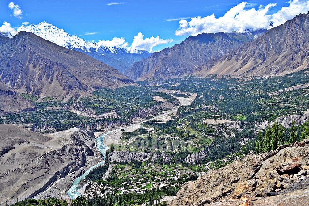
The Hunza Valley – A Place Beyond Words Welcome to The Hunza Valley, a Majestic Gem of Nature’s Grandeur – a place where nature’s beauty meets cultural heritage. Nestled in the heart of the mighty Karakoram Mountains, this remote valley is a hidden gem waiting to be explored. The words may fall short of capturing the true essence of The Hunza Valley. It is a place that needs to be experienced firsthand, where the mountains whisper ancient tales, and the valleys echo with the laughter of the locals. The serenity, the adventure, and the warmth of the people combine to create an unparalleled experience that will stay with you long after you leave. From its awe-inspiring landscapes to the warm hospitality of its people, the Hunza Valley offers a truly extraordinary experience that will leave you mesmerized. The Majestic Karakoram Range At the heart of The Hunza Valley lies the magnificent Karakoram Range. Towering peaks, snow-capped mountains, and sprawling glaciers adorn the landscape, creating a sight that will take your breath away. The Karakoram Range is home to some of the highest peaks in the world. Notable mountain peaks include K2, the second-highest mountain on earth, Broad Peak, and Gashabrum Peaks. Explore the stunning beauty of these majestic giants and immerse yourself in the grandeur of nature. Cultural Heritage and Warm Hospitality The Hunza Valley is steeped in rich cultural heritage. The local communities have preserved their traditions for centuries, and their warm hospitality will make you feel right at home. Engage with the locals, learn about their customs and traditions, and savor the flavors of their delectable cuisine. Immerse yourself in their vibrant festivals and witness the traditional dances that reflect the valley’s vibrant spirit. Traditional Music & Rituals Hunza is known for its rich cultural heritage, including traditional music and rituals. The people of Hunza have a distinct cultural identity, and their music and rituals are an integral part of their social and religious practices. Music holds a significant place in Hunza’s cultural traditions. In addition to their music, the people of Hunza have various rituals and celebrations that hold cultural and religious significance. Some of the notable rituals and celebrations include Ginani, Nasalo, Bofao, Nawruz, Salgirah of Imam e Zaman, Shab e Barat, Shab e Meraj, Eid Gadeer, Eid ul Fitr, and  Eid ul Adha. Traditional Cuisine  The valley is also famous for its delectable cuisine, featuring a variety of local dishes such as Chapshuro, Gurey Fiti, Makaye Fiti, Makaye Faqo, Burus Shapik, Giyaling, Hamao Giyaling, Hoi Lo Garma, Diram Fiti, Batering Dawdo, Buqpa Dawdo, Chap tze Dawdo, Haniye Del (Apricot Oil), Hani tze Dawdo, Hani tze Chamic (Apricot Sauce), Harisa, Sharbat, Mulida, Shopan, Chhamus,  and apricot-based desserts. The organic produce grown in the region, including cherries, apricots, and almonds, adds to the culinary delights of the valley. The Kha Basi Café on the premises of Altit Fort, Café De Hunza at Karimabad, Mulberry Hotel, Darbar Hotel, and Hidden Paradise offer a great taste of traditional food. Fruits of the Hunza Valley The journey of fruits in Hunza begins with cherries in May after the blossom season concludes in April and varieties of fresh fruits remain available until November. During winter, a variety of dry fruits and byproducts made of dry fruits are available in the market. Seasonal fruits include black, red, and white Cherries in May and June; Plum, Figs, and a variety of Apricots in June and July; Apples in July & August, a variety of grapes in August and September, Peach in September and October, and Japanese fruit in November. Outdoor Activities Exploring the Hunza Valley offers numerous outdoor activities for adventure enthusiasts. Visitors can embark on a thrilling trek to Ultar, hike up to Duikar from Karimabad or Altit, walk along the Hunza water channel or to viewpoints for panoramic vistas, go rock climbing, indulge in mountain biking, Paragliding from Duikar, or walk surrounding valleys. There are other exciting options including a trip to upper Hunza which covers the beautiful road trip to Khunjerab Pass, Rainbow Bridge Photography, a day hike towards Batura Glacier, visiting Borith Lake and walk up to the glacier, a day hike from Borith to Husseni village, Husseni Suspension Bridge crossing & Zip Line experience, hike up to Ondgra Poyga, explore Shishkat valley, boating at Attabad Lake, and visiting the magnificent Hoper Valley. The Karakoram Highway, which passes through the valley, provides an adventurous road trip experience with stunning vistas at every turn. Shopping in Hunza Karimabad, also known as Baltit, is the main bustling market with various shops, stalls, and local vendors selling a wide range of items in Hunza. Exquisite handicrafts such as carpets, rugs, embroidered textiles, traditional caps, shawls, and wooden carvings make for great souvenirs or gifts. Hunza is also famous for its gemstones and jewelry displayed in a variety of gemstone stores offering precious and semi-precious stones like turquoise, garnet, topaz, and more. Additionally, unique jewelry pieces inspired by the local culture are also seen on display. Moreover, delicious dried fruits, nuts, and apricot products including dried apricots, apricot oil, apricot jams, and apricot-based sweets like Hunza halwa. These local delicacies are a must-try and can be found in many shops. Similarly, traditional clothing such as embroidered shirts, woolen waistcoats, caps, gowns, and shawls featuring local craftsmanship and the cultural heritage of the region is easy to find in the market. Seasonal Attractions Blossoming Orchards The Hunza Valley is renowned for its vibrant orchards. As spring arrives, the valley transforms into a breathtaking paradise with the blooming of cherry, apricot, peach, and pear trees. The delicate pink and white blossoms create a picturesque scene, attracting visitors from far and wide. Take a leisurely stroll through the orchards, breathe in the sweet fragrance, and witness nature’s exquisite artistry unfold before your eyes. A Great Summer Retreat Certainly! The Hunza Valley is a breathtaking summer retreat. During the summer months, the Hunza Valley transforms into a paradise for travelers seeking respite from the scorching heat. The
karakoram highway tourist attractions
Blogs, City Breaks, Gilgit-Baltistan, Monuments, Roads & Highways

Karakoram Highway Attractions

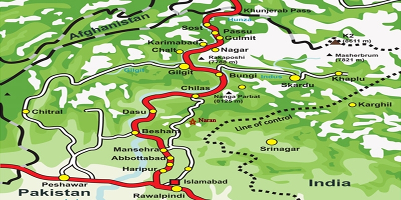
The Karakoram Highway (KKH): An Engineering Marvel  The Karakoram Highway (KKH), N-35, stands as one of the greatest wonders of the modern world. It is an awe-inspiring feat of human determination and ingenuity fondly referred to as the 8th wonder of the world. This 887-kilometer highway traverses along the Indus for 310 kilometers. Before meeting the Indus at the confluence of three mighty mountain ranges, it passes through Gilgit, Hunza, and Khunjerab. The highway runs through the Karakoram Range where 12 out of the 30 highest mountains in the world majestically overlook the KKH. Indeed, there is no other highway on earth that can rival the Karakoram Highway’s richness of attractions and breathtaking vistas. Origin and Journey of the Karakoram Highway Spanning an impressive 1300 kilometers (800 miles), the KKH commences its journey from the historic city of Hassan Abdal, approximately 45 kilometers from Islamabad on the Islamabad – Peshawar Highway. Its asphalt ribbon weaves through the cities of Abbottabad and Manshera crosses the majestic River Indus at Thakot, and continues on to Gilgit, meandering through the rugged mountains of Besham, Pattan, Sazin, and Chilas, before gracefully passing through Hunza and Sost. Finally, the highway reaches its zenith at the Khunjerab Pass, standing tall at an astonishing 4,733 meters (15,750 ft) above sea level. This pass, also known as Zero Point, marks the border between Pakistan and China. As the highway continues its journey, it enters the high Central Asian plateau and winds down through the Pamirs until it reaches Kashgar, situated at the western edge of the Taklamakan Desert. Gilgit-Baltistan is a treasure trove of history and natural wonders. It beckons travelers from all corners of the world to witness its splendor. As you explore this enchanting region, you will undoubtedly be captivated by the stories etched into its landscapes and monuments, a testament to the richness of its cultural heritage and the indomitable spirit of its people. Major Attractions along the Karakoram Highway The Karakoram Highway is undoubtedly crowned with a plethora of attractions, showcasing a harmonious blend of ancient rock carvings, awe-inspiring petroglyphs, mesmerizing natural beauty, and remarkable man-made marvels. Here are some of the major Karakoram Highway attractions that continue to captivate travelers from around the globe: The Khyber Pakhtunkhwa Section The Karakoram Highway passes through the plains, lush hills, and barren mountains of the Khyber Pakhtunkhwa before it enters the Himalayan range of Gilgit-Baltistan which boasts the height of the Karakoram Highway Attractions in the region. Mansehra Rock Edicts  Ashoka Rocks MansehraLocated on the north side of the town of Mansehra, the Ashoka Rocks bear witness to history with 14 edicts engraved by order of the Mauryan King Ashoka in the 3rd century BC. Although the Kharoshti script inscription is fading away, shelters have been built to protect this invaluable relic, making it accessible to visitors. The three granite boulders bearing 14 edicts engraved by order of the Mauryan King Ashoka in the 3rd century BC are located on the north side of the town of Mansehra. The inscription bearing Kharoshti script is fading away and almost impossible to see despite the shelters to protect it. Diamer Section: Threshold to Gilgit-Baltistan The Diamer Section runs in the rugged mountains for about 200km starting from the border between Tangir and Kohistan to Jaglot near the junction point of three great mountain ranges where Gilgit River and Indus converge. Shatial Petroglyphs A treasure trove of Buddhist archaeological wonders, the Shatial Rock Art Carvings or Petroglyphs can be found along the Karakoram Highway, previously known as the Old Silk Route. Carved into large rocks, these petroglyphs depict Jataka tales and Stupas, symbolizing the journeys of monks and pilgrims to Gandhara during the Buddhist era. Sadly, the construction of dams like the Diamer-Basha Dam and Dassu Dam has put these carvings in jeopardy, threatening their existence. Thalpan Petroglyphs The town of Chilas is surrounded by striking petroglyphs, particularly the ‘Chilas I’ site, which features inscriptions on both sides of the KKH and is considered a key Karakoram Highway Attraction spot. One of the most striking carvings here is the depiction of a large stupa with flying banners. Across the river, visitors can marvel at stones bearing art showcasing mythical animals, battle scenes, royal lineages, and Buddhist tales. Another site, ‘Chilas II,’ located near the police check post on the KKH, features a huge rock adorned with hunting and battle scenes, a Buddhist stupa, the long-horned ibex, and symbols of fertility. Nanga Parbat View The Thakot Bridge is the base point for an unforgettable journey to Fairy Meadows and the base camp of Nanga Parbat, famously known as the “Killer Mountain”. The bridge is situated approximately 78 kilometers south of Gilgit.  The Thalechi viewpoint offers travelers a perfect spot to pause and admire the sublime beauty of Nanga Parbat. Gems in Gilgit Region Gilgit is the administrative headquarters of Gilgit-Baltistan. The region is enormously blessed with historical monuments and breathtaking natural landscapes.  About 90km section of the Karakoram Highway from Jaglot to Guro (Jaglot) passes through the region. Partab Bridge The Partab Bridge is located about 40 kilometers southeast of Gilgit. It played a crucial role in connecting Gilgit with Bunji, Astore, and Kashmir long before the construction of the Karakoram Highway. Built between 1889 and 1893, this suspension bridge served as a vital communication link and facilitated trade. However, during the 1947 revolt when Gilgit gained independence from Dogra Raj, the bridge was burnt down. Despite facing decades of neglect, it was rebuilt after the 2010 floods, standing as a testament to human resilience. Junction Point of Three Great Mountain Ranges Jaglot, a mere 40 kilometers southeast of Gilgit, hosts the Junction Point of the Three Mountain Ranges. Here, the Karakoram, Himalaya, and the Hindukush converge. This unique location also marks the confluence of the Gilgit and Indus Rivers. About 5 km to the north, the Skardu road diverges from the KKH. Standing at the monument, visitors are treated to splendid views of the meeting of these three

Kha Basi Cafe
Gilgit-Baltistan, Heritage Sites in Pakistan

Kha Basi Café

Discover the Majestic Kha Basi Café: A Taste of Tradition in Hunza Valley Nestled under the shadow of the magnificent Altit Fort, within the ancient royal garden known as “the Kha Basi,” The Kha Basi Café is a truly exceptional restaurant. This hidden gem resides on the outskirts of Altit town, in the enchanting Hunza Valley, Gilgit-Baltistan, Pakistan. The cafe is basically surrounded by beautifully maintained apricot orchards. This classic restaurant stands as a testament to the region’s rich history and cultural heritage. A Glimpse into the Royal Past The Kha Basi Café’s historical significance is unparalleled. Once a summerhouse for the royal family of Hunza, this architectural gem has gracefully weathered the passage of time. Today, it stands as a living testament to the region’s glorious past. It exudes an air of old-world charm that enchants visitors from far and wide. Reviving Tradition through Culinary Delights As you step into the Kha Basi Café, prepare to embark on a culinary adventure like no other. The menu boasts an extensive selection of delectable dishes. At the same time, it also showcases the rich flavors of traditional Hunza cuisine. Every bite is a journey through the ages, offering a glimpse into the customs and culinary practices that have been cherished for generations. A Proudly Local Experience The heart and soul of the Kha Basi Café lie in the hands of the remarkable local women who manage it with utmost dedication. Their commitment to preserving the essence of Hunza’s heritage is evident in every detail of the café. From the warm greetings to the meticulously prepared dishes, every aspect of the experience exudes genuine hospitality and pride in the local culture. A Panoramic Feast for the Senses Beyond the culinary delights, the Kha Basi Café treats visitors to an unparalleled feast for the senses. The veranda, overlooking the majestic Karakoram Highway, mountains, and lush orchard offers a visual symphony that complements the flavors on your plate. The soothing sounds of nature, the gentle breeze rustling through the trees, and the fragrant blooms all contribute to an unforgettable dining experience. Preserving Culture Through Art and Architecture Delving deeper into its commitment to preserving culture, the café invites talented young artists to showcase their skills on special occasions. Their captivating performances range from traditional music and dance to storytelling, offering guests an immersive encounter with Hunza’s artistic heritage. Moreover, the small traditional house within the café’s premises provides an enchanting opportunity for visitors to experience the harmony of traditional architecture with modern comforts. The meticulous craftsmanship and use of indigenous materials in its construction pay homage to the region’s architectural legacy. A Photographic Paradise Nature’s masterpiece, the Kha Basi orchard, is a photographer’s dream come true. Each season unfurls its own breathtaking charm, from the delicate blossoms of spring to the vibrant colors of autumn. Photographers and nature enthusiasts alike will find endless inspiration within the enchanting confines of this picturesque garden. Getting There and Contact Information For those eager to explore the wonders of the Kha Basi Café, access is straightforward. Located at the end of the streets of Altit town, the café is easily reachable from the Karakoram Highway. Visitors can contact (0581) 3457012 during business hours for bookings and further information. The Kha Basi Café is more than just a restaurant. It provides an immersive experience that transports you to a bygone era of regal splendor and cultural richness. With its delectable cuisine, warm hospitality, and awe-inspiring surroundings, this enchanting establishment is a true gem in the heart of the Hunza Valley. Whether you are a food enthusiast, a culture aficionado, a nature lover, or a seeker of tranquility, the Kha Basi Café offers a magical journey that will linger in your memories forever. Discover the essence of Hunza’s heritage and indulge in an extraordinary culinary and cultural adventure that will leave you spellbound.

Khunjarab Pass
Gilgit-Baltistan, Passes

Khunjerab Pass

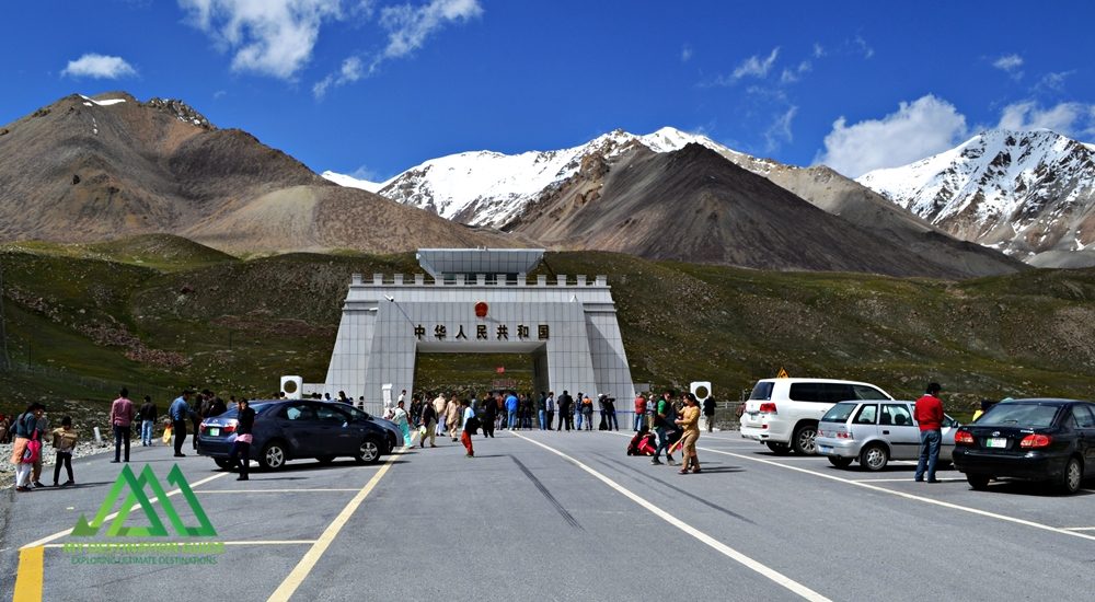
Discover the Khunjerab Pass: A High-Elevation Gateway The Khunjerab Pass, nestled at a breathtaking altitude of 4,700 meters, stands as the world’s highest paved international border crossing. It serves as a crucial junction linking the Gilgit-Baltistan region in northern Pakistan to China’s western Xinjiang province. This article delves into the beauty and significance of this remarkable pass, highlighting its construction, attractions, and access. Khunjerab Pass: A Natural Wonder Situated amidst the majestic Karakoram Mountains, the Khunjerab Pass, often referred to as Khunzerav, boasts expansive snow-capped peaks. During the summer months, this area transforms into a haven adorned with a kaleidoscope of wildflowers, creating a striking contrast against the glistening snow-clad mountains. The Khunjerab Pass offers some of the world’s most awe-inspiring scenery. The Birth of Hunza River This pass is the birthplace of the Hunza River. The snowmelt from the surrounding peaks converges to form a pristine creek that flows downward. Several of these tributaries ultimately merge to create the Hunza River, which eventually meets the Gilgit River in Gilgit. The Gilgit River continues its journey along the Karakoram Highway, eventually merging with the River Indus at the convergence of three mountain ranges before flowing onward to Thakot. Construction of the Khunjerab Pass Before the construction of the Karakoram Highway (KKH), the primary passes on the Karakoram Range were Kilik and Mintaka Passes to the north of Khunjerab. The decision to choose the Khunjerab Pass for the KKH was rooted in technical considerations. Kilik and Mintaka were deemed more vulnerable to air strikes. Consequently, Khunjerab was recommended in 1966 and realized in 1978. Attractions at Khunjerab Pass The Khunjerab Pass stands as a major tourist attraction, drawing both domestic and international visitors daily. The entire Karakoram Highway is a treasure trove of natural wonders and man-made marvels. At every turn, travelers are treated to breathtaking panoramas and opportunities for short hikes and photography. A journey along the highway to the border area promises a lifetime of unforgettable experiences. Khunjerab National Park A substantial portion of the Khunjerab Pass is enveloped by the Khunjerab National Park, established in 1979 to safeguard endangered species. Within the park’s boundaries dwell rare animals like the Marco Polo sheep and the elusive Snow Leopard. From the border area, visitors can gaze across the border into China’s Xinjiang province. Access to Khunjerab Pass Access to the Khunjerab Pass varies by location: Pakistani Side Sost Customs and Immigration Check Post: 75 km Hunza: 180 km Gilgit Airport: 280 km Islamabad (Capital City): 890 km Chinese Side Tashkurgan: 130 km Kashgar: Approximately 420 km Urumqui: 1,890 km Informative road signs provide tourists with distance-related information. It’s worth noting that traffic follows a right-hand drive on the Chinese side and a left-hand drive on the Pakistani side, making the border the transition point. Travel Tips While the Pakistani side of the highway is well-paved, the steep altitude gain near the pass can slow down your journey. Additionally, checkpoints on both sides can lead to further delays. On the Pakistani side, an entry fee is applicable to both local and international tourists. At present, the fee stands at Rs. 40 for Pakistani tourists and $8 for international tourists. It’s advisable to check for annual revisions of these fees to manage expenses, especially for larger groups. The Khunjerab Pass is open for trade and tourism from May to November. During the remaining months, it remains closed due to heavy snowfall. In November, the extreme cold and strong winds can make the visit challenging. However, under favorable weather conditions, it remains a must-visit destination. Bus Service A daily bus service operates between Sost, the last human settlement along the KKH in Pakistan, and Tashkurgan in China. Both Pakistani and Chinese buses provide transportation from their respective stations in their home countries. Travelers can also hire private cars or 4WD vehicles from Sost to Tashkurgan for drop-off and continue their journey to Kashgar using shared rides or taxis. Precautions for a Safe Journey Due to the high altitude, some tourists may experience altitude sickness, characterized by dizziness, headaches, or shortness of breath. It’s advisable to descend to lower altitudes immediately or carry altitude sickness medication in advance. During peak summer, there’s a risk of flooding due to rapid snowmelt near the pass, so a timely return is recommended. Additionally, loose gravel, especially during rainfall, can pose hazards on the highway. Whether you’re on a motorcycle or driving a car, exercise caution and avoid overconfidence. Despite renovations, the Karakoram Highway has claimed lives, particularly among tourists from lower-altitude cities. It’s essential to familiarize yourself with the entire highway before embarking on a self-drive tour. Embrace the journey and return home with cherished memories. Before You Go Pakistani tourists must carry their CNIC, while foreign tourists require a passport for identification. Foreign tourists and Pakistani nationals traveling to China must obtain a Chinese Visa (a pass for residents of Gilgit-Baltistan traveling to the nearby city of Kashgar). Buses from Sost to Tashkurgan depart in the morning between 8:00 AM and 9:00 AM, so purchasing tickets in advance is advisable. If you prefer to hire a car, private Pakistani vehicles are allowed to travel all the way to Kashgar. The fare is negotiable and not fixed.

Here the great mountain ranges of the Karakoram, Hindukush, and Himalaya converge
Gilgit-Baltistan

Junction Point of Three Mountain Ranges

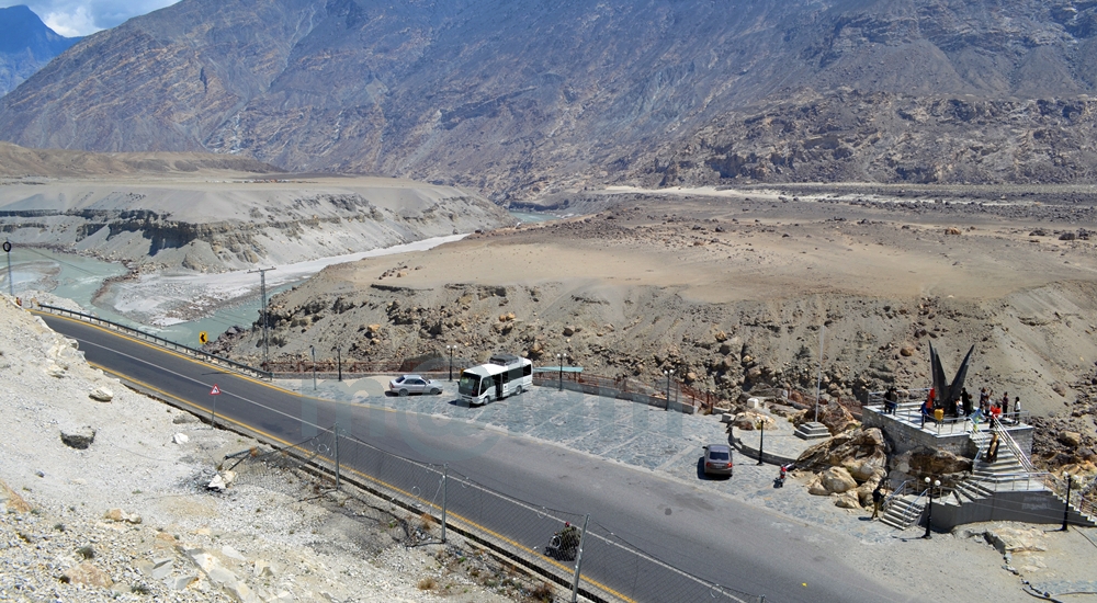
Unlocking the Secrets of the “Junction Point” of Three Majestic Mountain Ranges If you’re a true adventurer and nature enthusiast, there’s a hidden gem near Jaglot, just 40 kilometers southeast of Gilgit, Pakistan, that you absolutely must explore. It’s the awe-inspiring convergence of three of the world’s most famous mountain ranges: the Karakoram (known for its black gravel), the Himalaya (home of perpetual snow), and the Hindukush (aptly named the “killer of Hindus”). This unique location is often referred to as the “Junction Point of the world’s three great mountain ranges.” What’s more, this exceptional site also marks the meeting of the Gilgit and Indus Rivers, and the starting point of the Skardu road branching off from the Karakoram Highway (KKH). Geographic Significance: Where Worlds Collide The Junction Point isn’t just significant locally; it holds a unique place on the global stage. Pakistan is the only country where these three renowned mountain ranges converge, each boasting its highest peaks. Nanga Parbat, K-2, and Terich Mir are the standout peaks in the Himalayas, Karakoram, and Hindukush, respectively. These three ranges are considered sub-ranges of the mighty Himalayas, known as the trans-Himalayas. Standing at this point allows you to easily discern the direction of each mountain range. The Himalayan range lies to the south and east of the Indus River. The Karakoram range extends northeast from the Gilgit River, while to the west of the Gilgit and Indus Rivers, you’ll find the Hindu-Kush range. Exploring the Mountain Ranges: A Journey to Remember Karakoram Range: A World of Wonders The Karakoram Range, spanning approximately 500 kilometers, straddles the borders of Pakistan, India, and China. Within a radius of just 160 kilometers, it boasts the highest concentration of peaks soaring above 5,500 meters, numbering over 100. The crowning jewel of this range is K-2, the second-highest peak in the world, standing tall at 8,611 meters. The Karakoram is home to some of the planet’s longest glaciers, including Siachen, Batura, Baltoro, Biafo, Hisper, Gondogoro, and Chogolisa, making it one of the most heavily glaciated regions outside the Polar Regions. Himalayan Range: Nanga Parbat and Beyond The Himalayan range features Pakistan’s second-highest peak, Nanga Parbat, standing at an imposing 8,126 meters. Known as the “killer mountain” due to its formidable reputation, Nanga Parbat dominates the Astor District. The Great Himalayan Range stretches across 2,400 kilometers, encompassing Pakistan, Nepal, and India. Mount Everest, the world’s highest peak at 8,848 meters, calls Nepal home within this range. Hindu Kush Range: A Journey into History The Hindu Kush Range, spanning nearly 9,600 kilometers, is a land of its own wonders. While it primarily hosts smaller peaks, most standing below 7,500 meters, it covers the peaks of the Ghizer, Yasin, and Ishkoman valleys in Pakistan. The range reaches its zenith with Terich Mir, standing proudly at 7,708 meters in the district of Khyber Pakhtunkhwa. The Hindu Kush stretches from the Pamirs to Iran, offering a fascinating journey through history and geography. A Tourist’s Paradise: Unveiling the Junction Point A visit to this captivating site is a must for any traveler. It provides not only an educational experience but also a breathtaking panorama of the entire region, from the confluence of the Gilgit and Indus Rivers to the meeting of the three mighty mountain ranges. Local folklore weaves tales of the Junction Point being the residence of Jinns and fairies. Legend has it that these supernatural beings frequented the confluence of the rivers, using the waters for drinking and bathing. The Site: Your Gateway to Adventure An elevated platform, accessible by stairs, stands proudly on the edge of the Karakoram Highway. It offers a 360-degree view of the region and provides detailed information about the mountain coordinates. Adequate parking facilities are available for vehicles, and informative signboards offer essential information about the site. Regrettably, many, both within the country and from abroad, remain unaware of the significance of this captivating land. While some domestic tourists, particularly those traveling by public transport or passing by during odd hours or in the darkness, miss this gem, international tourists often include it as a vital stop on their itinerary. Best Time to Embark on Your Adventure The Karakoram Highway remains open year-round, allowing you to visit or pass by this unique site at any time of the year. However, the ideal time to explore Gilgit-Baltistan is from March to November, as the region’s winters can be harsh and freezing. Don’t miss the chance to stand at the crossroads of three remarkable mountain ranges, where nature’s grandeur knows no bounds. Visit Junction Point of Three Mountain Ranges, and let the magic of Pakistan’s unparalleled geography and history captivate your senses.

Rakaposhi
Gilgit-Baltistan, Mountains

Rakaposhi

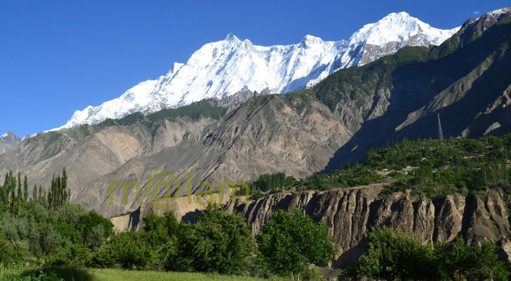
Unveiling the Magnificence of Rakaposhi: Pakistan’s Spectacular Mountain Rakaposhi is a renowned mountain peak nestled in the majestic Karakoram mountain range of Pakistan. It proudly graces the Nagar valley of Gilgit-Baltistan, flanked by the enchanting landscapes of Bagrot and Danyore. Standing tall as the 27th highest peak globally and holding the prestigious rank of being the 12th highest in Pakistan, Rakaposhi derives its name from the local vernacular, translating to “Snow Covered.” Locally, it is affectionately referred to as Bilchhar Dumani, signifying “Mother of Mist” or “Mother of Clouds.” A Breathtaking Encounter The journey to Rakaposhi’s awe-inspiring presence begins when one embarks on the Karakoram Highway (KKH) from Gilgit to Hunza. Opposite Kino Kutto, a rocky mountain aptly named in the local Shina language as “Black Knee” due to its shape, you are granted the first and most splendid glimpse of this majestic peak. While this spot is often referred to as the “Rakaposhi viewpoint,” the pinnacle of views lies in Ghulmet. Here, you are treated to a broader and more stunning panorama of Rakaposhi. The picturesque Jaffarabad village serves as a backdrop, marking your entry into the magical realm of the Hunza Valley. A Scenic Journey The scenic vistas of Rakaposhi continue to unfold as you journey along the Karakoram Highway, tracing your way through the Hunza Valley. However, if you opt to travel from the opposite side of the Hunza River, specifically through the lower Hunza or Shinaki valleys (including Khizr Abad, Hussainabad, Mayun, and Khanabad), you’ll be treated to captivating facets of Rakaposhi. The mountain reveals itself in all its glory, offering a different perspective on this natural wonder. To reach the Ghulmet viewpoint, situated approximately 5 km short of the main viewpoint, you can rejoin the Karakoram Highway. Ghulmet village, home to the famous viewpoint, lies roughly 75 km from Gilgit and is a favored vacation destination for travelers seeking Rakaposhi’s grandeur. An Unparalleled Ascent One of Rakaposhi’s most remarkable features is its astounding elevation gain of 5900 meters over a mere 11.2 kilometers of horizontal distance from the Hunza-Nagar River. It stands as the sole mountain peak worldwide that ascends directly from fertile cultivated fields. Rakaposhi’s distinction arises not merely from its rank but from the sheer magnificence it embodies. A Triumph in History The first successful ascent of Rakaposhi was achieved in 1958 by Mike Banks and Tom Patey, who undertook the challenging Southwest Spur/Ridge route. Their conquest, while awe-inspiring, came at the cost of minor frostbite. Tragically, another climber slipped and lost their life during the descent on that fateful night. A Sanctuary of Biodiversity The people of Nagar have dedicated the extended Rakaposhi Mountain region as a national park. It’s indeed a noble initiative inaugurated by the Minister for Northern Areas. This sanctuary is home to several endangered species. These include Marco Polo sheep, Snow Leopards, wolves, and a diverse array of wildlife. Rakaposhi’s natural beauty not only captivates the eye but also safeguards the precious biodiversity thriving within its vicinity. Rakaposhi stands not only as a symbol of natural wonder but also as a testament to human triumph and conservation efforts. Its allure continues to draw adventurers, nature enthusiasts, and conservationists. Additionally, this majestic mountain offers a profound connection with the splendor of the Karakoram mountain range. Besides, it boasts a rich tapestry of Pakistan’s natural heritage.

Rakaposhi View Point from the Karakoram Highway
Gilgit-Baltistan

Rakaposhi View Point

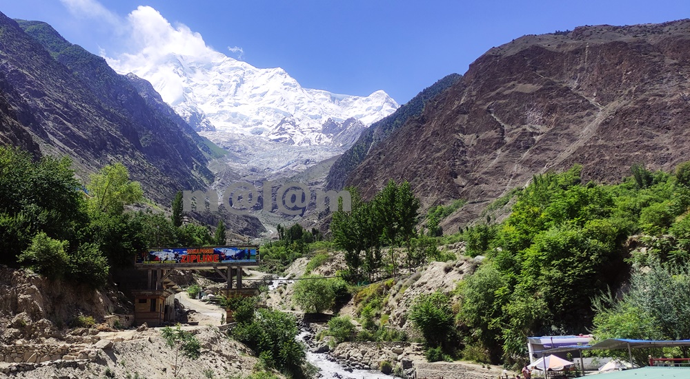
Rakaposhi View Point -A Close Encounter With The Shining Wall The Rakaposhi View Point undoubtedly stands as a testament to the unparalleled beauty of nature. The view point is situated in Ghulmet village, on the main Karakoram Highway, within the enchanting Nagar Valley. This extraordinary viewpoint offers an up-close and personal encounter with the awe-inspiring Rakaposhi mountain. Karakoram Highway: A Tapestry of Marvels The Karakoram Highway is much more than a mere asphalt artery connecting Pakistan and China through the Khunjerab Pass. It’s a highway especially adorned with a treasure trove of tourist attractions. The highway boasts natural wonders, archaeological marvels, cultural heritage, and architectural splendors. It beckons travelers to pause and immerse themselves in its allure. Rakaposhi View Point, nestled along this route, stands out as a prime exemplar of pristine natural beauty. An Oasis Amidst the Journey When traversing the road between Gilgit and Hunza, seasoned travelers always include a mandatory stop at Rakaposhi View Point. The shadow of Rakaposhi is the 27th highest peak globally, soaring at an elevation of 7,788 meters. Here one can find solace and delight in the lap of unparalelled natural grandeur. Moreover, the locale offers small terraces thoughtfully designed along the glacier-fed stream, inviting tourists to relish moments of relaxation, savor delicious meals, and capture stunning vistas. Summer Serenity: Immersing in Nature’s Bliss During the summer season, tourists revel in the joy of sitting by the stream, dipping their feet into the refreshing glacier water. Furthermore, this site is ideal for capturing the picturesque surroundings through their lenses. The symphony of flowing water, the verdant embrace of nature, and the grandeur of Rakaposhi provide an unforgettable experience. Evolution of Rakaposhi View Point The journey of Rakaposhi View Point from obscurity to acclaim has been nothing short of remarkable. The gradual surge in tourist footfall led to its growing prominence, which in turn catalyzed infrastructure development in the vicinity. The site boasts a plethora of attractions including the glacier nestled in greenery and the meandering stream driving a gentle breeze. In its nascent stage, Rakaposhi View Point was no more than a humble gift shop and a local eatery, primarily serving the needs of nearby travelers. Over time, local entrepreneurs embraced the opportunity, resulting in the establishment of gift shops, handicraft stores, convenience shops, restaurants, campsites, and even upscale tourist accommodations. A new road has been constructed, providing closer access to the glacier emanating from Rakaposhi, and work is underway to develop additional tourist attractions. The future holds the promise of turning this site into a premier tourist destination. Culinary Delights and More For travelers journeying between Gilgit and Hunza, Rakaposhi View Point stands as an ideal spot for a leisurely and sumptuous breakfast or an open-air lunch with breathtaking views. Not to be missed is the local specialty, “Chap-Shuro,” a unique kind of local pizza. The menu offers an array of fresh local cuisine at budget-friendly prices. Here, you can always count on delectable food coupled with personalized service. Rakaposhi View Point is not just a stopping point on your journey; it’s an invitation to immerse yourself in nature’s grandeur and indulge in local delights. Visit and be captivated by the magic of Rakaposhi and the wonders that surround it.

Key Facts about Pakistan
Blogs

Pakistan

Exploring Pakistan: A Treasure Trove of Diverse Experiences Pakistan stands as an exceptional and blessed nation, graced with some of Asia’s most breathtaking landscapes. Its geography is as varied as its rich cultures, and its people are known for their warm hospitality. In the realm of discovering the roots of modern-day humanity, few places on Earth rival Pakistan. Unraveling the Tapestry of History The land that now comprises Pakistan has been a cradle of ancient civilizations and a melting pot of cultures and dynasties for centuries. From the ancient Neolithic Mehergarh civilization, dating back 9000 years, to the illustrious 5000-year-old bronze age Indus Valley Civilization, the 3000-year-old Buddhist Gandhara Civilization, the opulent Mughal Era of the 16th century, the brief Sikh rule, to over two centuries of British occupation, leading to independence in 1947, Pakistan’s history is a tapestry of unparalleled events, unlike any other sovereign state. A Glimpse of Pakistan’s Geography Officially, the country is known as the Islamic Republic of Pakistan. Most importantly, Pakistan ranks as the 6th most populous nation in South Asia. Altogether, the country houses over 224 million people from diverse cultural and ethnic backgrounds. Encompassing 881,913 square kilometers (340,509 square miles), Pakistan boasts four provinces – Sindh, Baluchistan, Punjab, and Khyber Pakhtunkhwa – and three territories – Islamabad, Kashmir, and Gilgit-Baltistan. The carefully planned capital city, Islamabad, lies at the heart of this diverse nation. Pakistan’s strategic location at the crossroads of Asia divides it into three major geographic regions: the northern highlands, the Indus River plains, and the Balochistan Plateau. Bordered by the Arabian Sea’s 1046-kilometer coastline in the south, India to the east, China to the northeast, Afghanistan to the northwest, and Iran to the southeast, Pakistan’s diverse landscape includes glaciated mountain ranges in the north (Gilgit-Baltistan), fertile alluvial plains, expansive deserts, lush forests, plateaus, jungles, diverse flora and fauna, meandering rivers, and pristine lakes. A Bounty of Tourist Attractions Pakistan is a treasure trove of tourist attractions, each region offering a unique experience. Northern Adventures The northern mountainous regions encompass parts of KPK (Chitral, Swat, and the Kaghan Valley), Azad  Kashmir, and all of Gilgit-Baltistan. Altogether, the region forms the westernmost edge of the magnificent Himalayas. This area is a haven for adventure enthusiasts offering opportunities for trekking and mountaineering. Moreover, climbing, white-water rafting, mountain and desert jeep safaris, and paragliding are other activities adventurers can take up. Gilgit-Baltistan is proud to host the world’s highest mountains and longest glaciers outside the polar regions. The region undoubtedly makes it a magnet for adventurers. This region also marks the convergence of three mighty mountain ranges – the Karakoram, the Hindukush, and the Himalaya – along with the Pamir mountain range. It was once a vital trade route of the ancient Silk Route. Now, it is embodied by the Karakoram Highway, connecting Pakistan and China at Khunjerab Pass. This highway is adorned with over 100,000 petroglyphs and rock carvings, testifying to its rich Buddhist history. The region’s towering mountains, quaint valleys, terraced fields, ancient forts showcasing architectural marvels, and a history spanning centuries beckon travelers. Central Treasures Pakistan’s central regions feature dense forests, vast deserts, and fertile lands steeped in history and culture, boasting unique landmarks. In fact, ancient sites like Moenjo-Daro & Harappa of the Indus Valley Civilization, Taxila & Takht-i-Bahi of the Gandhara Civilization, and architectural gems from the Islamic era, Mughal Empire, Sikh rule, and the British era, found in cities like Lahore, Multan, Bahawalpur, Karachi, and Peshawar, enthrall domestic and international visitors alike. Southern Charms The southern regions, Sindh and Baluchistan, boast archaeological sites, religious landmarks, and architectural heritage. At the same time, its lakes and some of the world’s most stunning golden beaches along the coastal line earned a special place in the world of tourism. The Makran Coastal Highway from Karachi to Gwadar and Jiwani is a world-famous route, dotted with exclusive tourist attractions. Pakistan proudly hosts six UNESCO World Heritage Sites, with several dozen more awaiting recognition. The Rich Tapestry of Pakistani Culture Pakistan’s major cities bear the marks of both history and modernity. Diverse ethnic groups, each with its own cultural background, inhabit different parts of these cities. Moreover, these groups practice various faiths, wear vibrant costumes, speak unique languages, savor rich cuisine, and coexist harmoniously. This diversity, combined with the legendary hospitality of the people, evidently paints a true portrait of Pakistan. Accessing Pakistan Pakistan is accessible by road from China via the Khunjerab border and remains open from April to October end.  Similarly, Pakistan is accessible from Afghanistan via the Khyber Pass in the northwest. Likewise, Pakistan is accessible from Iran via the Taftan border, and from India via the Wahga border. Similarly, Pakistan is well-connected to the world through its international airports in Islamabad, Lahore, Multan, Peshawar, Sialkot, and Karachi. Embracing the Seasons Pakistan’s distinct seasons are complemented by its stunning landscapes. It includes towering mountain ranges, expansive glaciers, crystal-clear lakes, flowing rivers, extensive highways, trekking routes, terraced fields, historical monuments, diverse cuisines, and cultural tapestry, creating an enticing destination that attracts tourists in abundance.

Naltar Valley
Gilgit-Baltistan

Naltar Valley

Unveiling the Beauty of Naltar Valley: A Hidden Gem in Gilgit-Baltistan Nestled majestically amidst towering mountains at an astonishing elevation of approximately 15,000 feet lies the picturesque Naltar Valley, a true jewel near the town of Gilgit in the Gilgit-Baltistan region of Pakistan. This idyllic highland boasts the dual distinction of being a perfect summer escape and a world-renowned winter ski resort, attracting both national and international skiing enthusiasts year after year. Enveloped in lush greenery, adorned with pine, spruce, birch, rowan, and juniper trees, and cradled by emerald hills and snow-capped peaks, Naltar Valley is not only a natural wonder but also home to the Gujjar tribe, renowned for cultivating delectable and oversized potatoes. Exploring Naltar Valley: Geography and Accessibility Located approximately 19 kilometers uphill from the Nomal Valley, which serves as a base and is situated at the mouth of the gorge, Naltar Valley is easily accessible. The Nomal Valley itself is a mere 20-kilometer drive from Gilgit via the western bank of the Hunza River and about 70 kilometers from Hunza Valley, accessible via the Karakoram Highway, passing through Rahimabad and crossing a sturdy concrete bridge over the Hunza River. To reach Upper Naltar (Naltar Bala or Ajeeni Naltar in the local Shina language) from Gilgit takes approximately 2.5 hours, while the journey from Hunza extends to around 4 hours. A Haven for Travelers: Tourist Attractions in Naltar Valley Naltar Valley is a haven for those seeking respite from the urban hustle and bustle or yearning for unadulterated serenity. Whether you plan a day trip or opt for an overnight stay, the valley offers various accommodation options, including the possibility of camping. Key attractions in the area include: 1. Skiing Naltar has firmly established itself as a premier winter sports destination, hosting international ski competitions. Due to its elevated location, Naltar receives a substantial amount of snow each year, making it perfect for skiing. The Ski Federation of Pakistan operates ski lifts, and every February, the valley becomes a magnet for national and international athletes. 2. Trekking Routes Naltar Valley serves as the starting point for two enchanting medium-level treks: one leading to the Naltar Pass (approximately 4,600 meters) towards the east, connecting to the Ishkoman Valley, and the other traversing the Daintar Pass (4,636 meters) westward to Chalt. A two-hour drive spanning approximately 47 kilometers from Gilgit along the western bank of the Hunza River brings you to Nomal Village, your gateway to these exciting treks. 3. Lakes The journey from Upper Naltar to the lakes covers about 13 kilometers of jeep-able road. However, when the road is impassable or washed away, a scenic walking trail opens up. These hikes take several hours on foot depending on the condition. This rugged jeep track runs alongside a rivulet, leading you to the captivating Bashkiri Lake – I, Bashkiri Lake – II, and Bashkiri Lake – III, nestled closely together at the gorge’s end. Locally, these lakes are known as “Chimo Bari (Fish Lake),” “Chakar Bari (Multi Ends Lake),” and “Bodolok Bari (Turbid Lake).” These lakes are ensconced within dense pine forests. Winters bring harsh conditions and sometimes pile up to 10 to 15 feet of snow. Summers attract hordes of local and international tourists and trekkers eager to explore this natural wonder. 4. Rivulet Glacial waters originating near the Wakhan Corridor’s border converge to form a rivulet that meanders through the gorge’s heart until it meets the Hunza River. This natural watercourse provides opportunities for activities like camping, cooking, and irrigation. These various enjoyable activities along its pristine banks, enhance the overall visitor experience. 5. Camping and Outdoor Activities Naltar Valley boasts numerous camping sites, making it ideal for overnight or weekend camping adventures. The valley’s safety and availability of fresh vegetables at reasonable prices ensure a comfortable and enjoyable stay. The hiking trails leading to breathtaking viewpoints along with its magnificent medium-range mountains, provide ample opportunities for exploration. Naltar is also famous for its diverse flora and fauna. The Weather in Naltar Valley Naltar Valley enjoys perpetually romantic weather. Even during the peak of summer, the lakeside at Naltar experiences frequent light showers, adding to the area’s allure. The ever-changing romantic weather, combined with the stunning natural scenery, makes a visit to Naltar Valley an unforgettable experience. Culinary Delights Light refreshments like tea and cookies are available for tourists at the lakeside. However, visitors planning to spend an entire day at Naltar are advised to make personal meal arrangements. Accessing Naltar Valley Please note that the new road to the Naltar Valley is under construction and accessible solely by 4WD Jeeps. Transport and camping arrangements for overnight in tents, are available for your convenience.

chinese graveyard in danyore
Gilgit-Baltistan, Tombs

Chinese Graveyard

Chinese Graveyard: A Memorial of Mighty Engineers and Workers The Chinese Graveyard is locally known as China Yadgar or The Memorial Park. It stands as a poignant tribute to the mighty Chinese engineers and workers. The graveyard symbolizes the ultimate sacrifice during the construction of the Karakoram Highway (KKH) in the 1960s and 1970s. It is located in Danyore, approximately 10 km from the capital city of Gilgit-Baltistan in Pakistan. The cemetery serves as the final resting place for those who played a significant role in building the 1300 km (Pakistan: 887 km & China: 413 km) long Karakoram Highway. Historic Background of Karakoram Highway The Karakoram Highway was a remarkable joint venture between Pakistani and Chinese workers and engineers. It claimed the lives of 810 Pakistanis and about 200 Chinese during its construction. It was commenced in 1959 and concluded in 1977. The highway was officially opened to the public in 1979. As the KKH was being built on the Pakistani section, the Chinese workers who lost their lives were laid to rest in what is now known as the Chinese graveyard. Establishment and Renovation The Chinese graveyard was established in the early 70s. It served as a solemn reminder of the sacrifices made during the construction of the KKH. Recognizing its significance, the Chinese government decided to renovate the cemetery, and in 2013. Its renovation was carried out through a Chinese-funded project that successfully restored its condition. The Consular of the Chinese Embassy, Mr. Zhang Lianyou, and the then Gilgit-Baltistan (G-B) Assembly Speaker, Mr. Wazir Baig, laid the foundation stone for the new cemetery on April 05, 2013. The project was completed in October of the same year. Access and Location Access to the memorial park is open and free. A  designated custodian is appointed by the Chinese government to oversee its maintenance. Upon entering the main gate, visitors are greeted with a pictographic display on both sides of the pathway. These pictures depict the arduous construction work carried out by Chinese workers and engineers on the KKH under harsh conditions. Additionally, the display showcases the medical aid provided by Chinese doctors to the local community during the highway’s construction. A series of pictures with accompanying information highlights the reconstruction of the KKH. Moreover, the pictures feature the formation of tunnels, the erection of major bridges (such as the one in Shishkat over Attabad Lake and in Danyore over Gilgit River), and the provision of emergency transportation services across Attabad Lake amidst challenging environmental conditions. The display also offers historical information about the KKH in Urdu, Chinese, and English languages, presented on an adjoining concrete structure. Design and Layout The Chinese graveyard features a thoughtful design with four equally sized quarters bordered by a footpath. Each quarter comprises three rows of graves, totaling 27 tombs per quarter, amounting to 108 tombs in all four quarters. Each grave is marked by a tombstone bearing epitaph inscriptions in Chinese characters. Notably, 16 tombs in one of the quarters remain empty, representing the workers who lost their lives under debris during massive landslides or other incidents during the highway’s construction. Maintained with utmost care, the Chinese graveyard has become not only a place of remembrance but also a significant tourist attraction. It stands as a powerful symbol of the invaluable lives lost in pursuit of the Karakoram Highway. Moreover, the cemetery serves as a testament to the enduring friendship between Pakistan and China. The friendship continues to grow stronger over time. The Chinese Graveyard, or China Yadgar, stands as a solemn memorial to the indomitable spirit of the engineers and workers who contributed to the construction of the Karakoram Highway. It serves as a reminder of the sacrifices made and a testament to the unbreakable bond between Pakistan and China. As visitors pay their respects within the serene premises of the graveyard, they can’t help but appreciate the enduring friendship that has withstood the test of time.

Scroll to Top