
Karakoram Highway Attractions
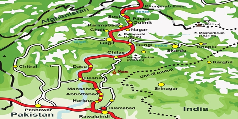
The Karakoram Highway (KKH): An Engineering Marvel The Karakoram Highway (KKH), N-35, stands as one of the greatest wonders of the modern world. It is an awe-inspiring feat of human determination and ingenuity fondly referred to as the 8th wonder of the world. This 887-kilometer highway traverses along the Indus for 310 kilometers. Before meeting the Indus at the confluence of three mighty mountain ranges, it passes through Gilgit, Hunza, and Khunjerab. The highway runs through the Karakoram Range where 12 out of the 30 highest mountains in the world majestically overlook the KKH. Indeed, there is no other highway on earth that can rival the Karakoram Highway’s richness of attractions and breathtaking vistas. Origin and Journey of the Karakoram Highway Spanning an impressive 1300 kilometers (800 miles), the KKH commences its journey from the historic city of Hassan Abdal, approximately 45 kilometers from Islamabad on the Islamabad – Peshawar Highway. Its asphalt ribbon weaves through the cities of Abbottabad and Manshera crosses the majestic River Indus at Thakot, and continues on to Gilgit, meandering through the rugged mountains of Besham, Pattan, Sazin, and Chilas, before gracefully passing through Hunza and Sost. Finally, the highway reaches its zenith at the Khunjerab Pass, standing tall at an astonishing 4,733 meters (15,750 ft) above sea level. This pass, also known as Zero Point, marks the border between Pakistan and China. As the highway continues its journey, it enters the high Central Asian plateau and winds down through the Pamirs until it reaches Kashgar, situated at the western edge of the Taklamakan Desert. Gilgit-Baltistan is a treasure trove of history and natural wonders. It beckons travelers from all corners of the world to witness its splendor. As you explore this enchanting region, you will undoubtedly be captivated by the stories etched into its landscapes and monuments, a testament to the richness of its cultural heritage and the indomitable spirit of its people. Major Attractions along the Karakoram Highway The Karakoram Highway is undoubtedly crowned with a plethora of attractions, showcasing a harmonious blend of ancient rock carvings, awe-inspiring petroglyphs, mesmerizing natural beauty, and remarkable man-made marvels. Here are some of the major Karakoram Highway attractions that continue to captivate travelers from around the globe: The Khyber Pakhtunkhwa Section The Karakoram Highway passes through the plains, lush hills, and barren mountains of the Khyber Pakhtunkhwa before it enters the Himalayan range of Gilgit-Baltistan which boasts the height of the Karakoram Highway Attractions in the region. Mansehra Rock Edicts Ashoka Rocks MansehraLocated on the north side of the town of Mansehra, the Ashoka Rocks bear witness to history with 14 edicts engraved by order of the Mauryan King Ashoka in the 3rd century BC. Although the Kharoshti script inscription is fading away, shelters have been built to protect this invaluable relic, making it accessible to visitors. The three granite boulders bearing 14 edicts engraved by order of the Mauryan King Ashoka in the 3rd century BC are located on the north side of the town of Mansehra. The inscription bearing Kharoshti script is fading away and almost impossible to see despite the shelters to protect it. Diamer Section: Threshold to Gilgit-Baltistan The Diamer Section runs in the rugged mountains for about 200km starting from the border between Tangir and Kohistan to Jaglot near the junction point of three great mountain ranges where Gilgit River and Indus converge. Shatial Petroglyphs A treasure trove of Buddhist archaeological wonders, the Shatial Rock Art Carvings or Petroglyphs can be found along the Karakoram Highway, previously known as the Old Silk Route. Carved into large rocks, these petroglyphs depict Jataka tales and Stupas, symbolizing the journeys of monks and pilgrims to Gandhara during the Buddhist era. Sadly, the construction of dams like the Diamer-Basha Dam and Dassu Dam has put these carvings in jeopardy, threatening their existence. Thalpan Petroglyphs The town of Chilas is surrounded by striking petroglyphs, particularly the ‘Chilas I’ site, which features inscriptions on both sides of the KKH and is considered a key Karakoram Highway Attraction spot. One of the most striking carvings here is the depiction of a large stupa with flying banners. Across the river, visitors can marvel at stones bearing art showcasing mythical animals, battle scenes, royal lineages, and Buddhist tales. Another site, ‘Chilas II,’ located near the police check post on the KKH, features a huge rock adorned with hunting and battle scenes, a Buddhist stupa, the long-horned ibex, and symbols of fertility. Nanga Parbat View The Thakot Bridge is the base point for an unforgettable journey to Fairy Meadows and the base camp of Nanga Parbat, famously known as the “Killer Mountain”. The bridge is situated approximately 78 kilometers south of Gilgit. The Thalechi viewpoint offers travelers a perfect spot to pause and admire the sublime beauty of Nanga Parbat. Gems in Gilgit Region Gilgit is the administrative headquarters of Gilgit-Baltistan. The region is enormously blessed with historical monuments and breathtaking natural landscapes. About 90km section of the Karakoram Highway from Jaglot to Guro (Jaglot) passes through the region. Partab Bridge The Partab Bridge is located about 40 kilometers southeast of Gilgit. It played a crucial role in connecting Gilgit with Bunji, Astore, and Kashmir long before the construction of the Karakoram Highway. Built between 1889 and 1893, this suspension bridge served as a vital communication link and facilitated trade. However, during the 1947 revolt when Gilgit gained independence from Dogra Raj, the bridge was burnt down. Despite facing decades of neglect, it was rebuilt after the 2010 floods, standing as a testament to human resilience. Junction Point of Three Great Mountain Ranges Jaglot, a mere 40 kilometers southeast of Gilgit, hosts the Junction Point of the Three Mountain Ranges. Here, the Karakoram, Himalaya, and the Hindukush converge. This unique location also marks the confluence of the Gilgit and Indus Rivers. About 5 km to the north, the Skardu road diverges from the KKH. Standing at the monument, visitors are treated to splendid views of the meeting of these three
Karakoram Highway Attractions Read Post »
