
The Karakoram Highway

karakoram highway tourist attractions
Blogs, City Breaks, Gilgit-Baltistan, Monuments, Roads & Highways

Karakoram Highway Attractions

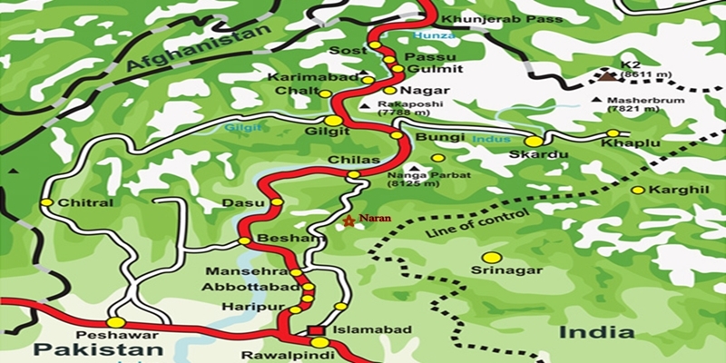
The Karakoram Highway (KKH): An Engineering Marvel  The Karakoram Highway (KKH), N-35, stands as one of the greatest wonders of the modern world. It is an awe-inspiring feat of human determination and ingenuity fondly referred to as the 8th wonder of the world. This 887-kilometer highway traverses along the Indus for 310 kilometers. Before meeting the Indus at the confluence of three mighty mountain ranges, it passes through Gilgit, Hunza, and Khunjerab. The highway runs through the Karakoram Range where 12 out of the 30 highest mountains in the world majestically overlook the KKH. Indeed, there is no other highway on earth that can rival the Karakoram Highway’s richness of attractions and breathtaking vistas. Origin and Journey of the Karakoram Highway Spanning an impressive 1300 kilometers (800 miles), the KKH commences its journey from the historic city of Hassan Abdal, approximately 45 kilometers from Islamabad on the Islamabad – Peshawar Highway. Its asphalt ribbon weaves through the cities of Abbottabad and Manshera crosses the majestic River Indus at Thakot, and continues on to Gilgit, meandering through the rugged mountains of Besham, Pattan, Sazin, and Chilas, before gracefully passing through Hunza and Sost. Finally, the highway reaches its zenith at the Khunjerab Pass, standing tall at an astonishing 4,733 meters (15,750 ft) above sea level. This pass, also known as Zero Point, marks the border between Pakistan and China. As the highway continues its journey, it enters the high Central Asian plateau and winds down through the Pamirs until it reaches Kashgar, situated at the western edge of the Taklamakan Desert. Gilgit-Baltistan is a treasure trove of history and natural wonders. It beckons travelers from all corners of the world to witness its splendor. As you explore this enchanting region, you will undoubtedly be captivated by the stories etched into its landscapes and monuments, a testament to the richness of its cultural heritage and the indomitable spirit of its people. Major Attractions along the Karakoram Highway The Karakoram Highway is undoubtedly crowned with a plethora of attractions, showcasing a harmonious blend of ancient rock carvings, awe-inspiring petroglyphs, mesmerizing natural beauty, and remarkable man-made marvels. Here are some of the major Karakoram Highway attractions that continue to captivate travelers from around the globe: The Khyber Pakhtunkhwa Section The Karakoram Highway passes through the plains, lush hills, and barren mountains of the Khyber Pakhtunkhwa before it enters the Himalayan range of Gilgit-Baltistan which boasts the height of the Karakoram Highway Attractions in the region. Mansehra Rock Edicts  Ashoka Rocks MansehraLocated on the north side of the town of Mansehra, the Ashoka Rocks bear witness to history with 14 edicts engraved by order of the Mauryan King Ashoka in the 3rd century BC. Although the Kharoshti script inscription is fading away, shelters have been built to protect this invaluable relic, making it accessible to visitors. The three granite boulders bearing 14 edicts engraved by order of the Mauryan King Ashoka in the 3rd century BC are located on the north side of the town of Mansehra. The inscription bearing Kharoshti script is fading away and almost impossible to see despite the shelters to protect it. Diamer Section: Threshold to Gilgit-Baltistan The Diamer Section runs in the rugged mountains for about 200km starting from the border between Tangir and Kohistan to Jaglot near the junction point of three great mountain ranges where Gilgit River and Indus converge. Shatial Petroglyphs A treasure trove of Buddhist archaeological wonders, the Shatial Rock Art Carvings or Petroglyphs can be found along the Karakoram Highway, previously known as the Old Silk Route. Carved into large rocks, these petroglyphs depict Jataka tales and Stupas, symbolizing the journeys of monks and pilgrims to Gandhara during the Buddhist era. Sadly, the construction of dams like the Diamer-Basha Dam and Dassu Dam has put these carvings in jeopardy, threatening their existence. Thalpan Petroglyphs The town of Chilas is surrounded by striking petroglyphs, particularly the ‘Chilas I’ site, which features inscriptions on both sides of the KKH and is considered a key Karakoram Highway Attraction spot. One of the most striking carvings here is the depiction of a large stupa with flying banners. Across the river, visitors can marvel at stones bearing art showcasing mythical animals, battle scenes, royal lineages, and Buddhist tales. Another site, ‘Chilas II,’ located near the police check post on the KKH, features a huge rock adorned with hunting and battle scenes, a Buddhist stupa, the long-horned ibex, and symbols of fertility. Nanga Parbat View The Thakot Bridge is the base point for an unforgettable journey to Fairy Meadows and the base camp of Nanga Parbat, famously known as the “Killer Mountain”. The bridge is situated approximately 78 kilometers south of Gilgit.  The Thalechi viewpoint offers travelers a perfect spot to pause and admire the sublime beauty of Nanga Parbat. Gems in Gilgit Region Gilgit is the administrative headquarters of Gilgit-Baltistan. The region is enormously blessed with historical monuments and breathtaking natural landscapes.  About 90km section of the Karakoram Highway from Jaglot to Guro (Jaglot) passes through the region. Partab Bridge The Partab Bridge is located about 40 kilometers southeast of Gilgit. It played a crucial role in connecting Gilgit with Bunji, Astore, and Kashmir long before the construction of the Karakoram Highway. Built between 1889 and 1893, this suspension bridge served as a vital communication link and facilitated trade. However, during the 1947 revolt when Gilgit gained independence from Dogra Raj, the bridge was burnt down. Despite facing decades of neglect, it was rebuilt after the 2010 floods, standing as a testament to human resilience. Junction Point of Three Great Mountain Ranges Jaglot, a mere 40 kilometers southeast of Gilgit, hosts the Junction Point of the Three Mountain Ranges. Here, the Karakoram, Himalaya, and the Hindukush converge. This unique location also marks the confluence of the Gilgit and Indus Rivers. About 5 km to the north, the Skardu road diverges from the KKH. Standing at the monument, visitors are treated to splendid views of the meeting of these three
Altit Fort Hunza
Forts, Gilgit-Baltistan

Altit Fort

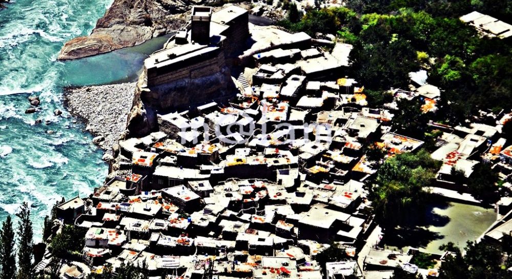
Altit Fort: A Journey Through History and Architecture In the mountain valley of Hunza, Gilgit-Baltistan, Pakistan, stands a true marvel of history and architecture, the awe-inspiring Altit Fort. The fort is perched majestically on a 1000-foot towering cliff rising sharply from the Hunza River. This 900-year-old fort has witnessed centuries of dynastic rule, and cultural transformations. The award-winning Altit Fort now stands as a testament to the rich heritage of the region. Its historic background, architectural marvels, and restoration efforts make Altit Fort a must-visit destination. Historic Background Before becoming a part of Pakistan in 1974, Gilgit-Baltistan was a patchwork of independent princely states, with the kingdom of Hunza being one of them. The local Mirs, hereditary rulers of Hunza, held sway until 1974. However, the socio-political reforms stripped them of their power during the reign of Zulfiqar Ali Bhutto. Altit Fort, which had once served as their palace, found itself in a state of disrepair. Later, the Aga Khan Foundation took over its renovation in 1990. The village of Altit, founded in the 11th century, was the oldest settlement and the capital of Hunza. It was then called Altit Khun and served as the capital of Hunza. Its name evolved from “Hunokushal” to “Burushal” as the region’s culture shifted from the Turkic Huns to Burushaski speakers, who later converted to Islam in the 15th century. The Power Struggle According to historical accounts, the rulers of Hunza first resided in the Altit Fort. The rivalry between two royal brothers, Prince Shah Abbas (Shabos) and Prince Ali Khan (Aliqan), marked a pivotal moment in the fort’s history. Shah Abbas relocated to Baltit Fort, making it the new seat of power, while Prince Ali Khan fortified Altit Fort. With the capital shifted to Baltit, Altit Fort began to lose its significance. Prince Ali Khan made Altit Fort his stronghold and launched offensives against his elder brother. Tragically, this conflict ended with Prince Ali Khan’s death. Balti Craftsmanship When Princess Shah Khatoon from Baltistan was married to Mir Ayaaho II of Hunza in the early fifteenth century, she was accompanied by craftsmen as a dowry. The Balti craftsmen carried out significant amendments to the fort with a Tibetan touch in its design. During their stay in Hunza, they used two Balti words to refer to the two forts “Elte” and “Delte” to say “here” and “there”. Later, the term Elte became Altit, and Delte was modified to Baltit as both valleys are famously known today. The fort was purposefully built by the ruling family of Hunza as a display of power, to defend Hunza from external attacks, and to safeguard the predominant feudal system. Altit Fort has undergone several ups and downs before it was abandoned. It has been dexterously renovated and serves as a tourist attraction. Currently, the fort houses a museum, a culture center, and the offices of a successful Social Enterprise. Architecture Altit Fort is a masterpiece of architectural ingenuity. Built over 800 years ago, its construction occurred in six distinct stages. The initial phase saw the construction of a two-floor building on the lower western edge, followed by a three-floor watchtower, a storage space, a mosque, grain storage on the eastern side, and the conversion of grain storage into guest rooms. Narrow corridors lead to the lower-level rooms, while the upper ones connect to the watchtower. The fort’s main entrance, facing Ultar, leads through a dimly lit corridor on the ground floor. It reveals a rectangular supporting structure with a haunting history. Legend has it that a prince who was suspected of plotting against his kingdom was buried here in a standing position. The first-floor royal kitchen boasts intricate carvings, surrounded by the lobby, a multipurpose traditional royal room, the queen’s room, and rubble stone masonry. The watchtower is strategically positioned to oversee the land. It offers a 360-degree view and was even used for executing prisoners sentenced to death. The mosque, royal throne, and guest rooms are situated to the north of the tower, while the storage space lies to the south. The royal throne, in front of the mosque, provides a panoramic view of Altit Khun. Restoration Altit Fort, once in a state of disrepair, was donated to the Aga Khan Trust for Culture Historic Cities Support Program in 2001 by Raja Amin Khan. Extensive restoration work, carried out by the Aga Khan Trust for Culture Historic Cities Support Program and the Government of Norway, transformed it into a museum. Over the years, various development projects both within and outside the fort have flourished. These include a women’s social enterprise, the restoration of Altit Valley, the Kha Basi Café serving traditional Hunza food, an apricot orchard, and a new art center cum guesthouse. Historical tours are offered daily from 9.30 am to 5.30 pm. Access and location Altit Fort is situated on the edge of Altit Valley, near the confluence of Hunza and Nagar rivers, approximately 3 km from Baltit Fort. The main entrance guides visitors through a royal garden—an apricot orchard surrounded by lush green grassland—leading to the fort entrance. The fort offers breathtaking views of Hunza and Nagar from various locations. The galleries in front of the royal guest rooms provide a stunning vista of Altit village. While those hanging from the royal chambers overlook the Hunza River and the Nagar Valley. Similarly, the watchtower atop the fort provides an unparalleled panoramic view of the Hunza and Nagar valleys, making it a photographer’s dream. Altit Fort also offers a captivating perspective from the Karakoram Highway. Awards In recognition of its cultural heritage conservation efforts, Altit Fort received the prestigious UNESCO Asia-Pacific Award in 2011. These conservation projects focused on rectifying structural defects, stabilizing walls, replacing rooftops, addressing wood decay, and improving lighting. Altit Fort stands as a living testament to the history and culture of Gilgit-Baltistan. Its architectural brilliance, rich history, and stunning location make it a must-visit destination for history enthusiasts and travelers alike. Experience the grandeur of Altit Fort and step back in time to a

Baltit Fort Hunza
Forts, Gilgit-Baltistan

Baltit Fort

Baltit Fort: Tibetan-Influenced Architectural Marvel Perched with a commanding view upon the moraine of Ultar Glacier, Baltit Fort stands as a testament to history. It offers a jaw-dropping vista of Hunza Valley and its intricate network of tributaries. This architectural gem, boasting over 700 years of history, was originally constructed as both a defensive stronghold and a symbol of authority by the rulers of Hunza. Today, it has transformed into a cultural center and museum. The fort is recognized globally and has secured numerous international awards. A Tale of Two States In a historical landscape where mountain kingdoms reigned supreme, Gilgit-Baltistan and Chitral were comprised of several small independent states. The Mirs, known as Thumo in Hunza and Nager, ruled their respective state. Notably, Hunza and Nagar, two major principalities separated only by the Hunza River, engaged in frequent clashes, fortifying their power with imposing strongholds. The chronicles of history reveal that the early Hunza rulers inhabited the Altit Fort, but a fierce conflict between the two sons of Mir Sultan, Shah Abbas (Shabos) and Ali Khan (Aliqan), led to their separation. Shabos, the elder son, relocated to Baltit Fort, ultimately solidifying its position as the epicenter of Hunza’s power. In the early 15th century, Ayasho II, Mir of Hunza at the time, forged a matrimonial alliance by marrying Princess Shah Khatoon from Baltistan, a region often likened to little Tibet. The princess brought with her a retinue of skilled craftsmen who orchestrated significant architectural modifications in both Altit Fort and Baltit Fort, creating a harmonious fusion of Tibetan and local architectural influences that still resonate in these structures today. The fortified village of Baltit, once known as “Agaai Koot” or the Heavenly Fort, and the nearby Altit, initially referred to as Hunokushal (derived from “Huns”), witnessed a linguistic evolution as Balti craftsmen introduced terms like “Elte” and “Delte” to denote “Here” and “There.” These linguistic nuances gave birth to the names Altit and Baltit, etching their place in history. Turbulence and Transformation The 19th century brought turmoil as the Maharaja of Kashmir launched attacks, followed by the British invasion in 1891. These incursions inflicted partial damage to the fort’s architecture and ushered in political upheaval in Hunza. In a daring move, Mir Safdar Ali Khan and Wazir Dadu, along with their families and supporters, sought political asylum in Kashghar. The British, in their pursuit of strategic control, reshaped the forts according to their defense needs. They dismantled the fortified walls and watchtowers of the old Baltit village and Baltit Fort. Additionally, they imposed their governance by appointing Mir Mohammad Nazim Khan as the ruler of the Hunza state. Subsequent alterations by Mir Mohammad Nazim Khan included demolishing several third-floor rooms and adding new ones, lending the fort a British colonial aesthetic with lime wash and colorful glass panel windows. These changes remained largely unchanged until the fort’s eventual restoration. Architectural Marvel Baltit Fort is a remarkable wooden pegged stone structure adorned with mud plaster. Its interior boasts exquisite woodcarvings that have since become a hallmark of architectural finesse. The three-story edifice perches gracefully on a moraine, affording breathtaking vistas of the valley below. The basement of the fort houses granaries and storage rooms, supported by narrow man-made terraces that safeguard its ancient foundations. Ascending to the first floor reveals the main kitchen, a winter guestroom, a spacious winter house, a private meeting room, guardrooms, and additional storage spaces, all interconnected for seamless functionality. The second floor graces visitors with living quarters, a balcony adorned with bay windows, and a magnificent open terrace, crowned by a Moghul-style wooden canopy sheltering a regal throne. This vantage point offers awe-inspiring views of the Hunza and Nagar valleys.  Moreover, the scenery of iconic  Rakaposhi, Diran Peak, Golden Peak, Ultar, and the Lady Finger is simply breathtaking. The fort’s third floor hosts a modest mosque and a guard shelter tucked away in the corner, completing the architectural splendor. Restoration and Renewal The fort was vacated by the local Mir family in 1945 and it remained abandoned for years, succumbing to decay. Concerned authorities contemplated its rehabilitation. Mir Gazanfar Ali Khan II, a descendant of the ruling Mirs of Hunza, made a momentous decision by gifting the fort to the Aga Khan Trust for Culture. This charitable organization embarked on a restoration project in 1989. Getty Grant Program (USA), the Norwegian Agency for Development Cooperation, and the French Authorities donated to the restoration project. The restoration efforts culminated in 1996, meticulously reviving the fort’s former glory. The restoration work was executed with such precision that it recaptured the fort’s bygone grandeur. The Mirs lost their power in 1974 as a result of the accession of princely states to the mainland. The Baltit Fort is serving as a museum now—a beacon of preserved culture for generations to come. Access and Appreciation Baltit Fort, nestled in Karimabad (Baltit), was once the capital of District Hunza. The fort is accessible via the Karakoram Highway (KKH), approximately 100 kilometers north of Gilgit, the capital of Northern Areas, Pakistan. The fort commands a panoramic view of the entire Hunza-Nagar region, making it easily discernible from the Karakoram Highway. Visiting Hours: Summer: 09:00 to 17:30 hrs (April 1st to Oct 30th) Winter: 09:30 to 16:00 hrs (November 1st to March 31st) Dining Amidst History In homage to the legacy of former Hunza state rulers, who hosted elaborate dinners and musical soirees at Baltit Fort, it is now possible to arrange a dinner with light music for groups of a minimum of eight guests. This unique dining experience features traditional dishes crafted from local organic produce, including dried apricots and the oil extracted from apricots, walnuts, and almonds. A Legacy of Awards Baltit Fort’s cultural significance and meticulous restoration have not gone unnoticed, earning it a cascade of prestigious awards: Grand Award to Aga Khan Cultural Services (AKCSP) in 1997 for “Restoration and Re-use of the Baltit Fort” by PATA (Pacific Asia Travel Association). British Airways Tourism for Tomorrow Global Award

Scroll to Top