Author name: admin

Babusar Pass
Khyber Pakhtunkhwa, Passes

Babusar Pass

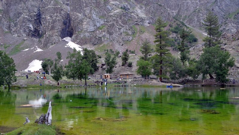
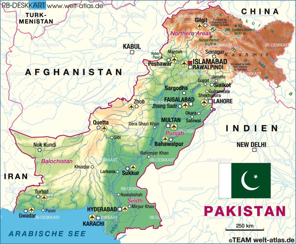
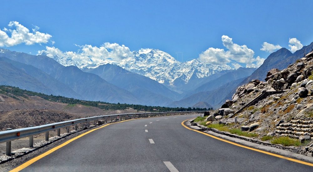
Babusar Pass: Discover the Mesmerizing Beauty of the Himalayas Babusar Pass, also known as Babusar Top, sits majestically at an elevation of 4,170 m (13,690 ft) as a captivating mountain pass in the Diamer District of Gilgit-Baltistan. Located about 70 km from Naran on the Naran-Gilgit road, this pass marks the southern boundaries of Chilas and is accessible from the Karakoram Highway by a 40km uphill paved road through Thak Nullah. It, therefore, forms a crucial link between the northernmost edge of the scenic Kaghan Valley in the Khyber Pakhtunkhwa (KPK) province of Pakistan and the Karakoram Highway in the Gilgit-Baltistan region and serves as a gateway to unparalleled beauty. Historical Significance of Babusar Top In the annals of history, Babusar Top held immense importance as it was a part of the ancient summer route that provided access to the Gilgit-Baltistan area long before the construction of the all-weather Karakoram Highway. This route was a lifeline from 1947 to 1978, connecting Gilgit-Baltistan with British India and subsequently with Pakistan. Even before the existence of Babusar Pass, the Burzil Pass (4,100m) served as the caravan route from Srinagar to Gilgit through Astore. Notably, the Kaghan Valley runs almost parallel to the Neelum Valley of Azad Kashmir, separated only by a mountain ridge. Accessible Yet Challenging While the Kaghan road through Babusar Pass offers a shorter and more picturesque path to Gilgit-Baltistan compared to the Karakoram Highway, its accessibility is limited. The pass remains open only for a brief period from early June to early November, subject to unpredictable weather patterns. The rest of the year, it becomes inaccessible due to heavy snowfall, rendering the Kaghan Valley a winter wonderland. Exploring the Enchanting Beauty The journey from Naran to Babusar Top is a mesmerizing experience, offering travelers a plethora of scenic vistas. Frozen peaks stand tall in the background, complementing panoramic valleys, vibrant waterways, lush forests, picturesque pastures, and green terraced fields. One of the prime attractions is the serene Lulusar Lake, a location that demands a peaceful stopover. Babusar Pass, with its magnetic charm, draws thousands of tourists on a daily basis during summer. For those visiting Naran, Babusar Top is an essential destination and a preferred day excursion and is always bustling with lively tourists, captivated by the awe-inspiring views of the surrounding mountains. It remains snow-capped during early summers, making it a delightful spot for tourists embarking on an excursion from Naran or heading towards Gilgit-Baltistan. The site is a photographer’s paradise, offering a splendid view from the top. On a clear day, the summit of Nanga Parbat, also known as the “killer mountain,” and the majestic peak of Malika Parbat (17,000 feet), the highest peak in the KPK district, are visible. Additionally, the snow-covered peaks of Kashmir present striking views on sunny days. The Source of Life: Melting Waters from the Mountains Surrounding Babusar Top Numerous streams and creeks converge into the Kunhar River, ultimately flowing into the Jhelum River in Kashmir. One of the most significant attractions is the stunning Lulusar Lake, the largest lake in the region, nourished by the waters of the Kunhar River. The Kunhar River gracefully flows through the length of Kaghan Valley, offering tourists the opportunity to experience rafting in this idyllic setting. Looking Ahead: Tourism Development Besides zip lines, there are a few decent restaurants on the top, and new hotels and restaurants are in the works. These facilities will undoubtedly enhance the appeal of Babusar Top, attracting more tourists to this enchanting destination. Traveler Tips: Enjoying Babusar Top to the Fullest Stock Up: Travelers planning to visit or pass through Babusar Top should ensure they have an adequate supply of food, warm clothing, necessary medicines, and a photography kit for capturing the beauty. Check the Weather: The weather can be unpredictable, so it’s essential to check the forecast before embarking on the journey. Altitude Considerations: Individuals prone to altitude sickness should avoid prolonged stays at the top to ensure a safe and enjoyable experience. Avoid Off-Season Travel: Due to extreme weather conditions, it’s best to avoid traveling during the off-season when the pass is closed. Vehicle Maintenance: Make sure your vehicle is in top condition, and have enough fuel for a hassle-free trip. Network Connectivity: Be aware that the top lacks cellular network coverage, making it impossible to make phone calls. Babusar Pass stands tall as an emblem of natural beauty, offering an unforgettable experience for adventurous souls and nature enthusiasts. As you venture through this captivating region, be prepared to be mesmerized by the grandeur of the Himalayas and the enchanting landscapes that unfold before your eyes. Whether you seek solace in the serene surroundings or embark on thrilling adventures, Babusar Top has something special for every traveler seeking the allure of the mountains. So, plan your journey wisely, and let the majestic Babusar Pass leave an indelible mark on your heart and soul.

Mohenjo-daro UNESCO World Heritage Site in Sindh
Archaeological sites, Sindh, World Heritage Sites

Mohenjo-Daro

Unlocking the Enigma of Mohenjo-Daro: A Dive into Ancient History Mohenjo-Daro also spelled as Mohenjodaro or Moenjodaro, holds a mystique as intriguing as its name, which translates to “Mound of the Dead.” This archaeological gem is nestled in the Sindh province of Pakistan, offering a window into the enigmatic Indus Valley Civilization (IVC) that thrived around 2600 BC. Mohenjo-Daro is one of the six UNESCO World Heritage Sites in Pakistan inscribed in 1980. The city’s original name remains a mystery. The Dawn of Civilization Our story begins around 5500 B.C. when a nomadic tribe settled in the villages west of the lower Indus River. These early settlers, adapting to their environment, mastered tools, constructed humble dwellings, cultivated crops, and tamed animals. Over centuries, as climate patterns evolved, lush jungles and thriving wildlife emerged. Gradually, this nascent community expanded both in size and influence, engaging in trade with regions as distant as Central Asia and the neighboring western territories. By 2600 BC, Mohenjo-Daro evolved into a civilization rivaling the sophistication of Mesopotamia and Egypt. Unveiling the Indus Valley Civilization The Indus Valley Civilization, also known as the Harappan Civilization, boasted two major cities, Harappa and Mohenjo-Daro, along with over 100 smaller settlements. It marked the dawn of urbanization in the Indian subcontinent. From 2600 B.C. to 1700 B.C., this civilization thrived on the fertile plains along the Indus River, showcasing remarkable literacy with a unique script consisting of 250-500 Dravidian characters. This civilization stands tall among the world’s great ancient cultures, with its initial discovery at Harappa in 1921, followed by Mohenjo-Daro in 1922. Rediscovery and Archaeological Endeavors The journey to resurrect Mohenjo-Daro’s glory began in 1922 when R.D. Banerji, an archaeologist with the Archaeological Survey of India, stumbled upon the site. A series of extensive excavations, overseen by renowned archaeologists, occurred until the 1930s. Later, in 1964-65, brief excavations resumed, only to be halted due to preservation challenges. Mohenjo-Daro’s sprawling ruins, stretching across approximately 750 acres, housed a peak population of around 40,000, making it one of the world’s largest and most advanced cities in its era. The city’s construction, characterized by unbaked bricks atop elevated mounds, exemplifies meticulous town planning principles. Urban Planning and Infrastructure Mohenjo-Daro’s urban layout followed a structured grid, with rectilinear buildings dominating the landscape. Most structures were constructed using standardized fired and mortared bricks, complemented by evidence of sun-dried bricks and wooden superstructures. The city comprised two main sections: the Citadel, standing 12 meters high and featuring two grand assembly halls and public baths, likely reserved for religious ceremonies, and the Lower City, comprising courtyard houses for the middle class. These houses featured brick stairs leading to flat roofs and small bathrooms equipped with drains and sanitation facilities. The Magnificent Great Bath A crowning jewel among Mohenjo-Daro’s structures is the Great Bath, astonishingly well-preserved after millennia. Measuring 180 feet by 108 feet, this structure features outer walls that are 7 to 8 feet thick, and lined with bitumen. This remarkable pool may have played a role in religious purification, with dimensions of 39 feet in length, 23 feet in width, and 8 feet in depth. Masterful Water Management Mohenjo-Daro boasted an intricate water management system, highlighted by a central marketplace well and smaller household wells. A sophisticated covered drainage system efficiently handled wastewater, while high-status residences included spacious homes with attached baths and integrated drainage. Many houses featured inner courtyards, their doors opening onto side-lanes. Achievements and Trade The people of Mohenjo-Daro exhibited advanced knowledge of weights, measures, and arithmetic with decimals. Their pottery showcased intricate geometric designs, and they crafted figurines reflecting their beliefs. Major crops included wheat, rice, mustard, dates, and cotton, while animals such as dogs, cats, camels, sheep, pigs, goats, water buffaloes, elephants, and chickens thrived. The presence of guard towers and defensive fortifications suggests that Mohenjo-Daro may have served as an administrative center. Archaeological evidence points to the city’s repeated destruction and reconstruction, with causes attributed to massive Indus River flooding or encroachment, mirroring a resilient spirit in the face of adversity. Unearthed Treasures Excavations at Mohenjo-Daro unearthed a treasure trove of antiquities. The findings include seated and standing sculptures, clay toys, pottery, stone axes, flake knives, coins, and copper and bronze artifacts. Among these, the iconic “Dancing Girl,” a 4,500-year-old bronze statue discovered in 1926, captures the imagination. Noteworthy discoveries also include the priest-king statue and a gold disc suggesting a third eye or “Bindi.” The Mysterious Decline Around 1700 B.C., a shadow fell over the Indus Valley Civilization, including Mohenjo-Daro. The precise cause of this decline remains shrouded in mystery. Theories range from shifts in the Indus River’s course to devastating floods or a decline in rainfall, leading to agricultural woes and eventual abandonment. Recent core drilling in 2015 revealed that Mohenjo-Daro’s true extent surpasses the excavated area. It is hinting at more secrets yet to be unveiled. Location and Accessibility For modern-day adventurers, the archaeological marvel of Mohenjo-Daro is situated approximately 510 km northeast of Karachi, 110 km southwest of Sukkur, and about 28 km from Larkana. Road access is available from Karachi, Bahawalpur, and Multan, making it a feasible day trip. Alternatively, Mohenjo-Daro boasts its airport, providing convenient access for travelers. Whether flying in from Karachi or taking a flight to Sukkur from major cities like Islamabad and Lahore, followed by a road journey to Moenjo-Daro, this ancient treasure is within reach, inviting you to step back in time. Intrigue and wonder continue to surround Mohenjo-Daro, beckoning explorers and historians alike to unlock the mysteries of this ancient marvel. This archaeological wonder serves as a testament to the ingenuity and resilience of a civilization lost to time. It is waiting to share its secrets with those who dare to delve into its history.

Takht-i-Bahi Monastery view with Mardan city in background
Archaeological sites, Buddhist Heritage, Buddhist Heritage, Buddhist Heritage of Pakistan, Khyber Pakhtunkhwa, World Heritage Sites

Takht-i-Bahi and Sahr-i-Bahlol

Takht-i-Bahi Monastery and Sahr-i-Bahlol Ruins in Gandhara, Pakistan In the heart of Mardan city, Khyber Pakhtunkhwa province, Pakistan, lie two historical treasures: the Takht-i-Bahi Monastery and the Sahr-i-Bahlol ruins. Both structures, dating back to the early 1st century, are situated merely 5 kilometers apart and have earned the prestigious title of UNESCO World Heritage Sites of Pakistan, a recognition bestowed upon them in 1980. Takht-i-Bahi: An Overview The name Takht-i-Bahi is a fusion of two Persian words, “Takht,” signifying “top” or “throne,” and “Bahi,” translating to “spring” or “water.” This nomenclature paints a vivid picture of a monastic complex perched atop a hill, overlooking a meandering stream. Another interpretation suggests that it could mean the “Throne of Origin.” Majestic Architecture The grandeur of the Takht-i-Bahi monastery sprawls across three interconnected spurs on a hill, rising from 36.6 meters to 152.4 meters in height. The primary structures grace the central spur, commanding a panoramic view of Mardan’s plains, accessible via a staircase boasting around 300 steps. Within this complex, you’ll find the main lower stupa court, the upper south stupa court, a Grid Monastery, an assembly hall, covered stepped passageways leading to dimly lit meditation cells, and various secular buildings. Additionally, scattered around the main complex, spread over 4 kilometers, are several units, potentially serving as residential areas or assembly halls, all visible from the hill’s summit. A Scenic Retreat The journey to the top of the Takht-i-Bahi archaeological relics hill rewards visitors with a breathtaking view. One can gaze across the plains, with Peshawar visible on one side and the Malakand Pass and Swat’s picturesque hills on the other. During winter, a thick blanket of fog sometimes envelops the region, shrouding even the nearby Takht-i-Bahi bazaar and Mardan City in an ethereal veil. Discovery and Historical Significance In 1836, the site’s existence was first noted by General Court, a French officer in the service of Maharaja Ranjit Singh. Dr. Henry Walter Bellew, a British medical officer born in India, explored it in 1864, leading to a series of excavations. Harold Hargreaves conducted further research from 1910 to 1911. The travel records of Chinese monk-pilgrim Xuanzang (602-64) also allude to this archaeological marvel. The site’s relics were mentioned for the first time in 1836 by the General Court. Dr. H.W. Bellew’s visit in 1864 resulted in a report detailing the remains and a stupa on the central spur. He also described sculptural fragments, possibly parts of large-scale sculptures. Subsequent excavations in 1871, reported by F.H. Wilcher, unearthed a total of 165 sculptural fragments, primarily depicting seated Buddhas and standing bodhisattvas. Unfortunately, the outcome of the 1911-1913 excavation was less fruitful due to inadequate record-keeping. In 1920, the site underwent significant restoration. Historically, the monastery thrived for 800 years, from the 1st century B.C. to the 7th century A.D. Archaeologists divide its history into four distinct periods: Foundation in the 1st century B.C., evidenced by inscriptions bearing the name of Gondophares (20-46 A.D.). Influence of Kushan kings, such as Kujula Kadphises and Kanishka, in the 1st and 2nd centuries. Development of the Stupa Court and Assembly Hall in the 3rd and 4th centuries. Construction of the Trantic complex with dark cells in the 6th and 7th centuries, overseen by invading Hun rulers. Architecture of Takht-i-Bahi The remains of the complex encompass four main areas: The central “Stupa Court,” features a cluster of Stupas surrounding a central courtyard. Monastic chambers, comprising individual cells arranged around a courtyard. A temple complex, housing several Stupas. Dark cells in the basement, designed exclusively for meditation. The entire structure is constructed using indigenous dressed and semi-dressed stone blocks, set in grey-colored limestone, adhering to Gandhara patterns. The site’s enduring reputation is founded on its remarkable preservation and strategic location, rendering it impervious to hostile incursions. Notably, stone sculptures from the site were relocated to the Peshawar Museum, while the stone inscription of Gondophares now resides in the Lahore Museum. Sahr-i-Bahlol: An Adjacent Enigma The second component of this historical tapestry is the Sahr-i-Bahlol ruins. Also referred to as Seri Bahlol or Sehr-i-Behlol, these ruins belong to a small fortified town from the Kushan period. A mound, approximately 9 meters high, is enclosed by a stone fortification wall. This wall, erected about 3,000 years ago, spans 9.7 hectares but has suffered damage at several points. The site holds remnants of Buddha that have not been adequately excavated. Regrettably, illegal excavations by local residents have led to the discovery of antiques such as statues, coins, jewelry, and utensils. Surrounded by fertile fields, this site now faces the threat of extinction due to ongoing construction. Access to These Treasures Takht-e-Bahi Monastery is located about 2 kilometers east of Takht-e-Bahi bazaar on the Mardan-Swat road, and approximately 15 kilometers north of Mardan city. Mardan itself is situated roughly 70 kilometers from Peshawar and can be reached within an hour and a half. The journey from Islamabad, spanning approximately 150 kilometers, takes around 2.5 hours. Both sites are suitable for a day excursion. Entry Timings: Summer: (1st April – 30th September) 08:00 am to 06:30 pm Winters: (1st October – 31st March) 09:00 am to 04:30 pm Holidays: The monastery remains open on holidays unless high-profile delegations are visiting or special instructions from higher authorities dictate otherwise. Entry tickets: For locals: Rs. 20 Foreign tourists: Rs. 500 Parking charges: All vehicle types: Rs. 50 Photography charges Applicable only to DSLR cameras: Rs. 500 Explore the rich history and architectural splendor of Takht-i-Bahi and Sahr-i-Bahlol, where the past comes to life amidst the enchanting landscapes of Gandhara, Pakistan.

Naltar Valley
Gilgit-Baltistan

Naltar Valley

Unveiling the Beauty of Naltar Valley: A Hidden Gem in Gilgit-Baltistan Nestled majestically amidst towering mountains at an astonishing elevation of approximately 15,000 feet lies the picturesque Naltar Valley, a true jewel near the town of Gilgit in the Gilgit-Baltistan region of Pakistan. This idyllic highland boasts the dual distinction of being a perfect summer escape and a world-renowned winter ski resort, attracting both national and international skiing enthusiasts year after year. Enveloped in lush greenery, adorned with pine, spruce, birch, rowan, and juniper trees, and cradled by emerald hills and snow-capped peaks, Naltar Valley is not only a natural wonder but also home to the Gujjar tribe, renowned for cultivating delectable and oversized potatoes. Exploring Naltar Valley: Geography and Accessibility Located approximately 19 kilometers uphill from the Nomal Valley, which serves as a base and is situated at the mouth of the gorge, Naltar Valley is easily accessible. The Nomal Valley itself is a mere 20-kilometer drive from Gilgit via the western bank of the Hunza River and about 70 kilometers from Hunza Valley, accessible via the Karakoram Highway, passing through Rahimabad and crossing a sturdy concrete bridge over the Hunza River. To reach Upper Naltar (Naltar Bala or Ajeeni Naltar in the local Shina language) from Gilgit takes approximately 2.5 hours, while the journey from Hunza extends to around 4 hours. A Haven for Travelers: Tourist Attractions in Naltar Valley Naltar Valley is a haven for those seeking respite from the urban hustle and bustle or yearning for unadulterated serenity. Whether you plan a day trip or opt for an overnight stay, the valley offers various accommodation options, including the possibility of camping. Key attractions in the area include: 1. Skiing Naltar has firmly established itself as a premier winter sports destination, hosting international ski competitions. Due to its elevated location, Naltar receives a substantial amount of snow each year, making it perfect for skiing. The Ski Federation of Pakistan operates ski lifts, and every February, the valley becomes a magnet for national and international athletes. 2. Trekking Routes Naltar Valley serves as the starting point for two enchanting medium-level treks: one leading to the Naltar Pass (approximately 4,600 meters) towards the east, connecting to the Ishkoman Valley, and the other traversing the Daintar Pass (4,636 meters) westward to Chalt. A two-hour drive spanning approximately 47 kilometers from Gilgit along the western bank of the Hunza River brings you to Nomal Village, your gateway to these exciting treks. 3. Lakes The journey from Upper Naltar to the lakes covers about 13 kilometers of jeep-able road. However, when the road is impassable or washed away, a scenic walking trail opens up. These hikes take several hours on foot depending on the condition. This rugged jeep track runs alongside a rivulet, leading you to the captivating Bashkiri Lake – I, Bashkiri Lake – II, and Bashkiri Lake – III, nestled closely together at the gorge’s end. Locally, these lakes are known as “Chimo Bari (Fish Lake),” “Chakar Bari (Multi Ends Lake),” and “Bodolok Bari (Turbid Lake).” These lakes are ensconced within dense pine forests. Winters bring harsh conditions and sometimes pile up to 10 to 15 feet of snow. Summers attract hordes of local and international tourists and trekkers eager to explore this natural wonder. 4. Rivulet Glacial waters originating near the Wakhan Corridor’s border converge to form a rivulet that meanders through the gorge’s heart until it meets the Hunza River. This natural watercourse provides opportunities for activities like camping, cooking, and irrigation. These various enjoyable activities along its pristine banks, enhance the overall visitor experience. 5. Camping and Outdoor Activities Naltar Valley boasts numerous camping sites, making it ideal for overnight or weekend camping adventures. The valley’s safety and availability of fresh vegetables at reasonable prices ensure a comfortable and enjoyable stay. The hiking trails leading to breathtaking viewpoints along with its magnificent medium-range mountains, provide ample opportunities for exploration. Naltar is also famous for its diverse flora and fauna. The Weather in Naltar Valley Naltar Valley enjoys perpetually romantic weather. Even during the peak of summer, the lakeside at Naltar experiences frequent light showers, adding to the area’s allure. The ever-changing romantic weather, combined with the stunning natural scenery, makes a visit to Naltar Valley an unforgettable experience. Culinary Delights Light refreshments like tea and cookies are available for tourists at the lakeside. However, visitors planning to spend an entire day at Naltar are advised to make personal meal arrangements. Accessing Naltar Valley Please note that the new road to the Naltar Valley is under construction and accessible solely by 4WD Jeeps. Transport and camping arrangements for overnight in tents, are available for your convenience.

UNESCO World Heritage Sites Of Pakistan
Blogs, Heritage Sites in Pakistan, World Heritage Sites

UNESCO World Heritage Sites of Pakistan

UNESCO World Heritage Sites of Pakistan – A Rich Tapestry of History and Culture Pakistan, strategically nestled at the crossroads of South Asia, boasts a wealth of historical treasures, archaeological wonders, and breathtaking natural landscapes. Its cultural diversity, manmade landmarks, and architectural heritage are nothing short of remarkable. The UNESCO World Heritage Sites in Pakistan represent the pinnacle of human achievement in terms of historic and cultural significance. These six sites are recognized for their outstanding universal importance and are entrusted to the world for preservation. Some of these landmarks have a history dating back 5,000 years. 1. Mohenjo-Daro: Archaeological Ruins The ancient city of Mohenjo-Daro, dating back 5,000 years, is a jewel of the Indus Valley Civilization. Situated on the banks of the River Indus in Larkana District, Sindh, it was unearthed in 1922. Mohenjo-Daro’s meticulously planned layout and early town planning system are evident, making it a remarkable archaeological site. While only one-third of the city has been discovered, ongoing efforts by the Pakistani government and UNESCO aim to conserve this cultural treasure. 2. Buddhist Ruins of Takht-i-Bahi and Sahr-i-Bahlol Takht-i-Bahi, meaning “spring throne” in Persian, and Sahr-i-Bahlol are two distinct sites that together constitute a UNESCO World Heritage Site. Located about 16 km from Mardan city, these Buddhist monastic complexes date back to the 1st century. Perched on hilltops, they have remained remarkably well-preserved due to their strategic locations. The main site, Takht-i-Bahi, features various sections, including the Court of Stupas, a monastic complex, a temple complex, and a tantric monastic complex. 3. Lahore Fort and Shalimar Gardens Lahore Fort and Shalimar Gardens are exquisite examples of Mughal-era craftsmanship from the 17th century. Located in Lahore, these sites showcase the artistic prowess of Emperor Shah Jahan’s reign. The fort, featuring marble palaces and mosques adorned with mosaics, stands in the northwest corner of the walled city. Shalimar Gardens, built in 1642, reflect Persian and Islamic traditions with their meticulously designed layout. 4. Makli Necropolis The Makli Necropolis in Thatta City of Sindh, dating back to the 14th century, houses approximately half a million tombs, making it one of the world’s largest Muslim necropolises. Spread across 10 square kilometers, these monuments and mausoleums showcase the rich heritage of Sindh. From famous rulers to scholars and philosophers, this site preserves a diverse range of historical figures from Hindu, Mughal, and Islamic traditions. 5. Rohtas Fort Rohtas Fort, also known as Qila Rohtas, is an architectural marvel located 16 km northwest of Jhelum City in Punjab. Built in 1541 by Sher Shah Suri, this fort served as a strategic stronghold to thwart Emperor Humayun’s return. The fort’s massive walls, bastions, and intricate gateways are a testament to early Muslim architecture. Though it was never used for its intended purpose, Rohtas Fort stands as a remarkable historical site. 6. Taxila Located approximately 35 km north of Rawalpindi/Islamabad, Taxila is an archaeological treasure trove. This ancient city, situated on a branch of the Silk Road, played a pivotal role in the evolution of Hinduism and Buddhism. Its history spans from the 5th century BC to the 2nd century AD, reflecting influences from Persia, Greece, and Central Asia. Taxila’s numerous sites, including Dharmarajika, Sirkap, Julian, and Mohra Muradu, offer a glimpse into its rich past and have been meticulously preserved for visitors to explore. In 1980, UNESCO declared Taxila a World Heritage Site by adding another layer to Pakistan’s rich tapestry of history and culture. These UNESCO World Heritage Sites not only celebrate Pakistan’s past but also provide a window into the diverse civilizations that have thrived in this region. As guardians of these treasures, it is our collective responsibility to ensure their preservation for generations to come. Tentative Sites in Pakistan In addition to the existing 06 UNESCO World Heritage Sites, Pakistan has a list of 25 tentative heritage and natural sites. Recently, eight of these sites gained approval for inclusion in this prestigious list. These new additions include Derawar Fort in Cholistan, Hingol Cultural Landscape in Balochistan, Nagarparkar Cultural Landscape in Sindh, Central Karakoram National Park and Deosai National Park in Gilgit-Baltistan, Ziarat Juniper Forest and Karez System Cultural Landscape in Balochistan, and the Khewra Salt Mines in Punjab.

Tourism in Pakistan
Blogs

Tourism in Pakistan

Unlocking Pakistan’s Tourism Potential: A Journey Through Its Natural and Cultural Wonders Pakistan is a country abundant in tourist attractions that can help improve Tourism in Pakistan. By potentially marketing its available resources and adopting a tourism-friendly policy, this country can become the top tourist destination in the world. Undoubtedly, its unique terrain, cultural diversity, vibrant history, variety of cuisines, distinct weather patterns, and welcoming people can make it a distinctive country in the world. Discovering Pakistan’s Diverse Landscape Pakistan is a country nestled between the formidable Himalayan Mountains in the north and the serene Arabian Sea coastline in the south. Overall, the country is a treasure trove of natural and cultural wonders in an expansive 796,095 square kilometers. Pakistan’s approximately 240 million people boasts a rich tapestry of attractions, making it a prime destination for tourists worldwide. Geography and Accessibility The country is positioned strategically on the world map. Geographically, Pakistan shares its borders with China to the northeast, India to the southeast, Afghanistan to the north and northeast, and Iran to the southwest. In addition, its 1046-kilometer coastline along the Arabian Sea completes its geographical diversity. Accessibility to Pakistan is facilitated through international flights, with Pakistan International Airlines (PIA) offering direct connections to the US, Canada, Europe, the Middle East, and China. Likewise, international carriers such as Emirates, Qatar Airways, and Turkish Airlines serve major Pakistani airports in Islamabad, Lahore, Peshawar, and Karachi, connecting the nation to the world. A Glimpse into Pakistan’s Tourism History Pakistan’s journey in the tourism sector has been a tumultuous one. Following the partition of the subcontinent, tourism was initially administered by the Ministry of Railways until 1955. Later transitioned to the Ministry of Commerce in 1964. Subsequently, it became part of the Civil Aviation Department before the establishment of the Tourism Development Corporation of Pakistan (TDCP) and the Ministry of Tourism in 1972. However, between 1977 and 1996, tourism was placed under the Ministry of Culture, Sports & Tourism. A dedicated Ministry of Tourism was established in 2004. Despite these bureaucratic changes, Pakistan’s tourism sector faced challenges in realizing its full potential, with limited policy support and insufficient attention. The 18th Amendment further devolved tourism to the provinces, resulting in neglect and missed opportunities. The Golden Era of Pakistani Tourism The zenith of Pakistan’s tourism industry was witnessed during the 1970s, 1980s, and mid-1990s. It was the time the country welcomed a record number of international tourists, primarily from Europe and America. Pakistan was celebrated as a premier tourist destination, celebrated for its breathtaking natural beauty and captivating cultural heritage. Unforgettable Attractions During this period, international tourists flocked to Pakistan to explore iconic destinations such as Karachi’s monuments and beaches, Lahore’s Mughal treasures, Peshawar’s legendary Khyber Pass, Taxila’s ancient ruins, and the bustling bazaars of Rawalpindi. Cultural enthusiasts marveled at Chaukandi tombs, Makli Hills, Shah Jahan Mosque in Thatta, Mohenjo-Daro, Bahawalpur’s palaces and forts, Multan’s shrines, Swat’s Buddhist heritage, Rohtas Fort, and the mesmerizing salt mines. Adventure seekers were drawn to the scenic valleys of Gilgit-Baltistan and Chitral. Particularly the enigmatic Kalash tribe, the awe-inspiring Karakoram Highway leading to the Pak-China border at Khunjerab, and exhilarating trekking and mountaineering expeditions through the northern mountainous terrain. Economic Prosperity Through Tourism The flourishing international tourism industry stimulated growth across various sectors. Airlines, hotels, restaurants, travel companies, tour operators, and transportation services all thrived. Museums, forts, ancient sites, souvenir shops, and other tourist-related businesses enjoyed consistent income streams. The ripple effect of international tourism contributed to a sense of prosperity and contentment across the country for over two decades. The Downfall: Challenges and Setbacks However, the turn of the century brought unfortunate setbacks to Pakistan’s tourism industry. Events such as the tragic 9/11 incident had a devastating impact on international tourist arrivals. The subsequent “war on terror” painted Pakistan as a hotbed of terrorism, tarnishing its image on the global stage. This negative perception led to a decline in inbound tourism, causing many tourism-related businesses to scale down or close. Efforts to revive international tourism were slow to materialize. Biased media portrayal exacerbated the situation, creating significant challenges for the government, tourism stakeholders, and the public. Efforts to Revive Tourism Despite these challenges, various initiatives were launched at home and abroad to rekindle international interest in Pakistan as a tourist destination. “The Guardian” published “The top five tourist sites in Pakistan” after the devastating earthquake of 2005.  Taxila, Lahore, Lake Saif ul Muluk, Karakoram Highway, and Karimabad were the key focus as attractions. In 2007, Pakistan initiated the “Visit Pakistan” marketing campaign. This year-long effort featured fairs, festivals, sporting events, arts and crafts shows, folk festivals, and historical museum openings. These efforts gained international recognition when The World Economic Forum’s Travel & Tourism Competitiveness Report ranked Pakistan as a top 25% tourist destination for its World Heritage sites in 2009. Despite these achievements, the tourism industry experienced fluctuations, partly due to global economic crises. The Vital Role of Stakeholders Private tour operators played a crucial role in maintaining international connections through electronic and social media promotion. They also actively participated in major international tourism fairs like ITB and WTM. Pakistani missions abroad can enhance their role by promoting the country’s attractions on embassy websites and participating in international tourism fairs. Simplifying the visa process is another critical step. Successful tourism economies like China, India, Iran, and Nepal owe their success to government support, tourism-friendly policies, and effective destination marketing. Pakistan must follow suit by efficiently marketing its tourism treasures through various media channels. Challenges and Competitors Challenges persist as competitors invest in activities that discourage tourism to Pakistan, resulting in travel advisories from potential markets. This diminishes inbound tourism and foreign exchange earnings. Pakistan’s Abundant Attractions Pakistan’s unique geographical location, spanning from the Arabian Sea to the majestic K2, offers an unparalleled array of attractions. Scenic valleys, vast deserts, golden beaches, tranquil lakes, flowing rivers, diverse flora and fauna, rich cultures, ancient ruins, and captivating man-made structures make Pakistan a truly exceptional destination. Coastal

chinese graveyard in danyore
Gilgit-Baltistan, Tombs

Chinese Graveyard

Chinese Graveyard: A Memorial of Mighty Engineers and Workers The Chinese Graveyard is locally known as China Yadgar or The Memorial Park. It stands as a poignant tribute to the mighty Chinese engineers and workers. The graveyard symbolizes the ultimate sacrifice during the construction of the Karakoram Highway (KKH) in the 1960s and 1970s. It is located in Danyore, approximately 10 km from the capital city of Gilgit-Baltistan in Pakistan. The cemetery serves as the final resting place for those who played a significant role in building the 1300 km (Pakistan: 887 km & China: 413 km) long Karakoram Highway. Historic Background of Karakoram Highway The Karakoram Highway was a remarkable joint venture between Pakistani and Chinese workers and engineers. It claimed the lives of 810 Pakistanis and about 200 Chinese during its construction. It was commenced in 1959 and concluded in 1977. The highway was officially opened to the public in 1979. As the KKH was being built on the Pakistani section, the Chinese workers who lost their lives were laid to rest in what is now known as the Chinese graveyard. Establishment and Renovation The Chinese graveyard was established in the early 70s. It served as a solemn reminder of the sacrifices made during the construction of the KKH. Recognizing its significance, the Chinese government decided to renovate the cemetery, and in 2013. Its renovation was carried out through a Chinese-funded project that successfully restored its condition. The Consular of the Chinese Embassy, Mr. Zhang Lianyou, and the then Gilgit-Baltistan (G-B) Assembly Speaker, Mr. Wazir Baig, laid the foundation stone for the new cemetery on April 05, 2013. The project was completed in October of the same year. Access and Location Access to the memorial park is open and free. A  designated custodian is appointed by the Chinese government to oversee its maintenance. Upon entering the main gate, visitors are greeted with a pictographic display on both sides of the pathway. These pictures depict the arduous construction work carried out by Chinese workers and engineers on the KKH under harsh conditions. Additionally, the display showcases the medical aid provided by Chinese doctors to the local community during the highway’s construction. A series of pictures with accompanying information highlights the reconstruction of the KKH. Moreover, the pictures feature the formation of tunnels, the erection of major bridges (such as the one in Shishkat over Attabad Lake and in Danyore over Gilgit River), and the provision of emergency transportation services across Attabad Lake amidst challenging environmental conditions. The display also offers historical information about the KKH in Urdu, Chinese, and English languages, presented on an adjoining concrete structure. Design and Layout The Chinese graveyard features a thoughtful design with four equally sized quarters bordered by a footpath. Each quarter comprises three rows of graves, totaling 27 tombs per quarter, amounting to 108 tombs in all four quarters. Each grave is marked by a tombstone bearing epitaph inscriptions in Chinese characters. Notably, 16 tombs in one of the quarters remain empty, representing the workers who lost their lives under debris during massive landslides or other incidents during the highway’s construction. Maintained with utmost care, the Chinese graveyard has become not only a place of remembrance but also a significant tourist attraction. It stands as a powerful symbol of the invaluable lives lost in pursuit of the Karakoram Highway. Moreover, the cemetery serves as a testament to the enduring friendship between Pakistan and China. The friendship continues to grow stronger over time. The Chinese Graveyard, or China Yadgar, stands as a solemn memorial to the indomitable spirit of the engineers and workers who contributed to the construction of the Karakoram Highway. It serves as a reminder of the sacrifices made and a testament to the unbreakable bond between Pakistan and China. As visitors pay their respects within the serene premises of the graveyard, they can’t help but appreciate the enduring friendship that has withstood the test of time.

The Karakoram Highway
Blogs, Gilgit-Baltistan, Roads & Highways

The Karakoram Highway

Exploring the Karakoram Highway: A Journey Through History and Scenic Beauty The Karakoram Highway (KKH) stands as a testament to human determination and engineering feats. It connects China and Pakistan via the Khunjerab Pass, situated at an awe-inspiring altitude of 4,733 meters. This epic roadway is not just a trade artery but also a legendary tourist attraction. It offers a captivating blend of historic landmarks, cultural diversity, and breathtaking natural beauty. For adventure enthusiasts, embarking on a journey along the KKH is an absolute thrill. Traversing Pakistan’s Section: A Scenic Odyssey The KKH adventure begins in Hasanabdal, Punjab, Pakistan. It stretches across an impressive 887 kilometers until it reaches the Khunjerab Pass at the Pak-China border. Along this route, the highway meanders through the rugged terrain of Khyber Pakhtunkhwa (KPK). It then follows the course of the Indus River and gracefully navigates the Karakoram and Pamir Mountains. Eventually, it meets the Chinese segment at Khunjerab Pass. In China, this remarkable highway is known as the Friendship Highway. Due to the harsh conditions it was built, it is sometimes referred to as the “Eighth Wonder of the World.” Unveiling the Route: A Glimpse into the Length The total length of the Karakoram Highway spans approximately 1,300 kilometers, with 887 kilometers in Pakistan and 413 kilometers in China. While the new route doesn’t exactly replicate the ancient Silk Route, it closely follows the same region, reviving the spirit of this historic trade network. The construction of the KKH came at a significant human cost, with both Pakistani and Chinese laborers toiling relentlessly to complete each kilometer of this ambitious project. Chinese workers who lost their lives during construction are honored at the Chinese cemetery, China Yadgar, in Danyore near Gilgit. Historic Roots: A Glimpse into the Past Historically, the Karakoram Highway was a vital caravan trail, serving as one of the branches of the ancient Silk Route. Over centuries, traders, pilgrims, warriors, and common folk traversed this route, ushering in profound changes in the social, cultural, and economic aspects of the region. The Saga of Construction: Overcoming Challenges Before the Karakoram Highway was built, the northern areas, now known as Gilgit-Baltistan, attracted the interest of the Russians, Chinese, and British, owing to its strategic significance. However, access to the region was a formidable challenge. In the 1800s, the British, who were in power, aimed to bolster their authority by constructing an all-weather communication infrastructure along the Indus. Realizing this vision was no small feat. Initially, the British improved an old Srinagar foot track, transforming it into a mule track. Later, a seasonal passage was established through Chilas, crossing the Babusar Pass to connect to the Kaghan Valley. Unfortunately, this passage remained open for only about six months a year during the summer. Following the partition of the subcontinent in 1947, the Srinagar road was permanently blocked. This period saw the northern areas divided into several states under local rulers. In 1958, the Indus Valley Road (IVR) project was conceived to create an all-weather road link between Swat and Gilgit. Construction commenced in 1959 as a joint venture between the two governments. Then, in 1966, a Sino-Pak agreement transformed the IVR into the Karakoram Highway. Despite financial constraints and the outbreak of the war between Pakistan and India in 1971, China’s invaluable support enabled the project to continue. Originally planned to stretch from Thakot to the Khunjerab Pass, the entrance point was later shifted to Hasan Abdal, and the project was completed in 1979. The highway was finally opened to the public in 1986. During construction, approximately 800 Pakistanis and 200 Chinese workers lost their lives, primarily due to landslides. Unofficial estimates suggest an even higher toll. The Chinese workers were laid to rest at the Chinese Graveyard in Danyore near Gilgit. A Path to Reconstruction: Upgrading the KKH In June 2006, Pakistan’s National Highway Authority (NHA) and China Road and Bridge Corporation (CRBC) signed an MoU to upgrade the KKH, expanding its overall width from 10 to 30 meters. This expansion aimed to accommodate heavy-duty vehicles, even in extreme weather conditions. Although construction took place, the width remained largely unchanged from the original design. During the construction phase, a significant event occurred on January 4, 2010, known as the Attabad incident. A massive landslide in the Attabad valley of Hunza damaged a section of the highway, creating a 23-kilometer-long lake and disrupting travel along the Karakoram Highway. To restore the road link between Pakistan and China, the construction of tunnels along a revised 24-kilometer route began in July 2012 and was completed in September 2015. This realigned route featured five tunnels and a bridge, rejuvenating the connection between the two countries. The Geopolitical Significance: A Strategic Artery The Karakoram Highway traverses a region marked by towering mountains and geological complexities, where China, Tajikistan, Afghanistan, and Pakistan converge within a 250-kilometer radius. Due to the intricate Kashmir conflict between India and Pakistan, the KKH holds strategic and military importance for these nations, especially Pakistan and China. Beyond geopolitics, the Karakoram Highway has significantly bolstered trade and tourism between Pakistan and China. The construction of the highway resulted in uplifting the living standards of the local population. The China-Pakistan Economic Corridor (CPEC) is set to bring substantial economic gains to the region, with plans to connect the Karakoram Highway to the southern port of Gwadar in Balochistan through the Chinese-aided Gwadar-Dalbandin railway, extending to Rawalpindi. Discovering Tourist Gems: Treasures Along the KKH The Karakoram Highway has earned international acclaim as a niche adventure tourism destination. Beginning in Hasan Abdal, about 50 kilometers from Rawalpindi city, this dual-carriage asphalt ribbon departs from the dusty plains of Punjab, embarking on a journey through the lower Himalayas of Hazara district. As it heads north, it winds through numerous captivating natural and historic sites, ultimately reaching the Pakistan section’s culmination at the Khunjerab border in the upper Hunza valley. This 887-kilometer stretch of the Karakoram Highway in Pakistan is a diverse tapestry of tourist attractions. From the

Wazir Khan Mosque
Mosques, Punjab

Wazir Khan Mosque

Unlocking the Beauty of the 17th-Century Wazir Khan Mosque in Lahore The Wazir Khan Mosque bearing Mughal-era Architecture is located in the heart of Lahore. The glorious mosque was built during the illustrious reign of Mughal Emperor Shah Jahan. The mosque stands as an unrivaled masterpiece captivating visitors from all corners of the world. This architectural marvel not only showcases the quintessential essence of Mughal design but also serves as a testament to their unwavering commitment to precision, frescoes, and artistic finesse. Often, this glorious mosque is referred to as “a mole on the cheek of Lahore”. A Glimpse into History Before delving into the grandeur of the mosque itself, it’s essential to understand the man behind its name. Wazir Khan was originally known as Hakim Sheikh Ilm-ud-din Ansari who hailed from humble origins in Chiniot, Punjab. He embarked on a path of education, specializing in medicine, and eventually found his way to the Mughal court. In 1620, Prince Khurram, who would later become Shah Jahan, recognized Hakim Ansari’s exceptional skills. He appointed Ansari as his personal physician and acknowledged his competence and dedication. The prince honored him with the title “Wazir Khan,” signifying his role as a minister in the Mughal court. The Mazar of Miran Badshah The mosque’s history intertwines with the construction of a tomb for a revered Sufi saint, Syed Muhammed Ishaq, also known as Miran Badshah. This tomb, or Mazar, served as the spiritual center around which the Wazir Khan Mosque would later emerge. Construction of the mosque began in 1634 and continued until 1641, encapsulating the tomb of Miran Badshah within its sacred precincts. Today, the tomb remains nestled in the mosque’s courtyard, a silent witness to centuries of devotion and architectural splendor. Discovering its Location The Wazir Khan Mosque is situated within the ancient walled city of Lahore. The glorious mosque occupies a prime position along the road connecting the Lahore Fort to the Delhi Gate. It occupies an impressive area of 279 feet by 159 feet resting on an elevated plinth. An intriguing aspect of its design is the inclusion of 22 shops, forming a bustling bazaar along the sides of a brick-paved pathway leading to the mosque—a testament to the integration of commerce and culture. The Architectural Marvel The Wazir Khan Mosque boasts a single prayer aisle and five bays, evoking architectural similarities with the Mosque of Mariyam Zamani Begum in the same city. Likewise, its high-arched galleries gracefully encircle a central brick-paved courtyard. The 130-foot-long prayer chamber is framed by simple cusped arches supported by sturdy piers. The mosque features three majestic domes, with the central dome soaring higher than the rest, emphasizing the exquisitely detailed mihrab. Its ingeniously designed double domes help amplify the voice of the imam. The voice therefore extends to the farthest corners of the courtyard. Adding to its charm, the mosque is surrounded by 32 guestrooms, known as Hijars. The mosque’s walls are constructed with meticulously cut and dressed bricks. Each wall is adorned with frescoes in a mesmerizing array of colors, including cobalt, cerulean blue, green, orange, yellow, and purple. These walls are meticulously divided into compartments to accommodate glazed patterns. Moreover, its walls are inscribed with calligraphy in Arabic and Persian. The mosque’s grills are crafted from terracotta, enhancing its visual appeal. The floors of the mosque are adorned with vibrant tiles featuring intricate geometric designs, showcasing the artisans’ craftsmanship. Unique to the Wazir Khan Mosque are its four minarets. Each tower with a remarkable height of 107 feet is adorned with mosaic tiles. These distinctive designs reflect a regional style rarely seen in Mughal capital mosques. The mosque’s domes, constructed in the Lodi style, further add to its architectural uniqueness. A Timeless Attraction Even today, the Wazir Khan Mosque continues to mesmerize not only the local populace but also draw visitors from across Pakistan and around the world. It stands as a testament to the enduring allure of Mughal architecture. Wazir Khan Mosque serves as a prominent landmark in Lahore’s rich cultural heritage.  The Wazir Khan Mosque is an absolute must-visit destination for those seeking a glimpse into the opulence and artistry of the Mughal era. The Wazir Khan Mosque in Lahore is not merely a historical site but a living testament to the grandeur, elegance, and artistic finesse of the Mughal dynasty. With its rich history, breathtaking architecture, and cultural significance, it remains a jewel in the crown of Lahore’s architectural heritage, beckoning travelers and history enthusiasts to explore its timeless beauty.

Lake View Park
Islamabad

Lake View Park

Exploring Lake View Park: A Pristine Oasis in Islamabad Lake View Park, also known as Rawal Lake Park, graces the Federal Capital, Islamabad, as a captivating haven for leisure and picnicking enthusiasts. Nestled near Malpur village, this modern park beckons individuals from diverse backgrounds, offering a plethora of recreational opportunities. Unleashing the Excitement: Recreation at Lake View Park Rawal Lake, a picturesque expanse, stands as the sole destination offering a medley of exciting activities, from water sports to fishing. The park boasts several distinct sections designed to cater to people of all ages and interests. Let’s explore them: 1. Sitting Pagoda Embrace tranquility and serenity as you relax in the elegant sitting pagoda, overlooking the breathtaking lake. 2. Picnic Point Gather your loved ones and immerse yourself in the joy of picnicking amidst the lush greenery of Lake View Park. 3. Ibex Club For those seeking exclusive recreational experiences, the Ibex Club awaits with its refined amenities and services. 4. Rock Climbing Gym Challenge your adventurous spirit by scaling the rock walls at the park’s rock climbing gym. 5. Motorsports Ranch Experience the thrill of motorsports at the ranch, where you can satisfy your need for speed. 6. Fancy Aviary Step into a world of colorful plumage as you explore the park’s enchanting aviary. 7. Festival Arena Celebrate life’s moments in the festival arena, where events and gatherings come to life. 8. Passenger Road Train Embark on a delightful journey around the park aboard the passenger road train. 9. Paintball Battlefield Engage in exhilarating battles on the paintball battlefield, perfect for group adventures. 10. Swimming Pool Cool off and unwind in the refreshing waters of the park’s swimming pool. Culinary Delights and More Lake View Park spoils visitors with a variety of food outlets, ensuring that your refreshment needs are met promptly. Moreover, for aficionados of open-air cooking, the park provides Bar BQ grills for delightful gatherings with family and friends. It’s undeniably a retreat that caters to people of all backgrounds. Harmonious Melodies: Live Music at the Park Immerse yourself in the rhythm of live music performances by professional artists at Lake View Park. If you’re musically inclined, bring your instruments to entertain fellow visitors, all while respecting their need for privacy. A Haven for Nature Enthusiasts Lake View Park boasts an animal park and an aviary that houses unique and stunning birds. Notably, it holds the distinction of being the world’s third-largest aviary. The sanctuary also features a bird’s hospital for treatment and vaccination, as well as a bird’s shop for those passionate about feathered friends. This park is truly a paradise for bird lovers and researchers. A Verdant Oasis With its diverse array of trees, lush greenery, and vibrant blooms, Rawal Lake Park is a testament to nature’s beauty. The park provides organized car parking facilities for the convenience of visitors. While daily visitors hail from the immediate vicinity of Rawalpindi and Islamabad, weekends draw students from nearby cities and villages. Moreover, Lake View Park has earned acclaim among foreign tourists visiting Islamabad, making it a must-visit destination. Enjoy captivating performances by artists on the park’s elevated podium, adding to the park’s allure. Finding Your Way Lake View Park is conveniently located on Murree Road, partially encircling Rawal Lake. To be precise, the entrance to this enchanting park is approximately 2km from the roundabout near Islamabad Club, along Murree Road. Administered by the Capital Development Authority (CDA), the park is nestled on the shores of Rawal Lake, an artificial reservoir serving the water needs of Rawalpindi and Islamabad. Preserve the Beauty While Lake View Park was created for the enjoyment of a pristine environment and manicured lawns for relaxation and play, it is crucial to address recent issues. Unfortunately, some visitors have not been respectful of the park’s beauty, neglecting proper waste disposal. To preserve this natural oasis, it is imperative to educate visitors about environmental responsibility and maintaining cleanliness. Lake View Park stands as a cherished gem in Islamabad, offering a myriad of recreational experiences amidst nature’s splendor. Whether you seek adventure, serenity, or simply a place to unwind, this park welcomes all with open arms.

Scroll to Top