Author name: admin

Khewra Salt Mines
Punjab

Khewra Salt Mine

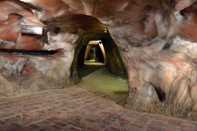
Unveiling the Splendor of Khewra Salt Mine: Pakistan’s Natural Wonder Discovering the World’s Second Largest Salt Deposit The Khewra Salt Mine, also known as the Mayo Salt Mine, stands as a testament to nature’s awe-inspiring wonders. Nestled within the Salt Range Khewra, an administrative subdivision of Jehlum District in Punjab Province, Pakistan, this majestic mine holds the distinction of being the world’s second-largest salt deposit and Pakistan’s largest. Within its subterranean chambers lies the treasure trove of Pink Himalayan Salt, beckoning visitors from around the globe to witness its marvel. Let’s delve into the remarkable history and captivating attractions of this geological marvel. A Geological Heritage The Khewra Salt Mine traces its origins back an astonishing 800 million years, a time when a shallow sea’s evaporation and geological movements set the stage for its formation. It remained concealed from the world until 320 BC, when the legendary Alexander the Great ventured into this region with his army. Legend has it that Alexander’s horses were drawn to the salt-rich rocks on the surface, and even ailing steeds found solace in licking the salt stones. This discovery piqued the interest of the Greeks, eventually leading to mining activities by the local Janjua tribes in the 13th century. The Mughal Flourish The Mughal era witnessed the mine’s transition from tribal control. Salt from Khewra became a prized commodity, reaching markets as distant as Central Asia. However, with the decline of the Mughal Empire, the mine changed hands again, this time to the Sikhs, earning its moniker ‘Khewra Salt Mine.’ The British Influence In 1849, the British Empire ousted the Sikhs and annexed Punjab, taking charge of the Khewra Salt Mine. In 1872, British Mining Engineer Dr. H. Warth introduced advanced excavation techniques, including the ‘room and pillar’ method, still in use today. This method involves extracting only 50% of the salt from the working stratum while leaving the rest as supportive pillars. A Geological Wonder Located 945 feet (288 meters) above sea level, the Khewra Salt Mines stretch over 300 kilometers within the Salt Range, from Beganwala near River Jhelum to Kalabagh near River Indus. Nineteen stories comprise this remarkable mine, with eleven below ground. The labyrinthine tunnels extend approximately 40 kilometers, maintaining a constant temperature of 18–20 °C year-round. Covering an expansive 110 square kilometers, the underground expanse never fails to astound. A Tourist’s Paradise The Khewra Salt Mine isn’t just a geological marvel; it’s also a major tourist attraction, drawing in approximately 250,000 visitors annually. Exploring the mine is a breeze, thanks to a small electric trolley train that guides visitors on a two-hour journey through its depths. Inside, you’ll encounter crystalline pools of salty water, intricate buildings, and replicas of iconic landmarks, all crafted by local artisans. Notably, the Salt Mine houses the world’s only Salt-Mosque, the Badshahi Masjid, constructed from salt bricks that cast a mesmerizing kaleidoscope of colors when illuminated. The mine continuously evolves, ensuring there’s always something new to captivate visitors. Salt Therapy for Health Beyond its geological wonders, the Khewra Salt Mine offers therapeutic benefits. The Khewra Asthma Clinic, established in 2007, pioneers salt therapy for asthma and respiratory ailments. By inhaling antibacterial salt particles in a sterile environment, patients experience relief in clearing air passages, especially asthma sufferers. With a ten-day treatment regimen, patients can witness remarkable improvements in their respiratory health. Health Benefits of Himalayan Pink Salt Himalayan pink salt, sourced from this mine, offers an array of health benefits, including: Detoxifying the body and regulating water levels Clearing sinus and respiratory issues Promoting healthy sleep patterns Maintaining pH levels Regulating blood sugar and reducing blood pressure Anti-aging properties Enhancing food nutrient absorption Aiding vascular health Supporting kidney and gallbladder health Boosting digestion and metabolism Balancing adrenal gland function Ensuring cellular hydroelectric energy balance Strengthening bones Easing stress Treating emotional disorders Preventing various ailments Commercial Applications Khewra salt isn’t limited to its therapeutic and aesthetic qualities. It serves as Pakistan’s renowned rock salt, used in cooking, as bath salt, and as a raw material for various industries. The mine also produces exquisite decorative items such as lamps, vases, ashtrays, and statues, exported worldwide. This tradition dates back to the Mughal era when craftsmen fashioned tableware and decorations from this precious resource. Access and Timings Khewra is conveniently located, approximately 160 kilometers from Rawalpindi/Islamabad (2-3 hours) and 260 kilometers from Lahore (3-4 hours). The Khewra Salt Mines welcomes tourists daily, from 9 am to 6 pm, including Sundays and gazette holidays. Fees Entrance fees vary for visitors: Pakistani visitors: Adults: Rs. 220 per person Children (2-12 years): Rs. 110 per child Students: Rs. 110 per student Foreign visitors: Adults: $20 per person Children (2-12 years): $10 per child Students: $10 per student For further inquiries, contact the Project Manager at Khewra Salt Mines, Khewra, District Jhelum, at +92-544-231137. The Khewra Salt Mine is a testament to nature’s grandeur, offering not only geological marvels but also therapeutic benefits and commercial value. As you embark on your journey to this extraordinary site, prepare to be mesmerized by the age-old wonder that is the Khewra Salt Mine.

Hiran Minar
Monuments, Punjab

Hiran Minar

Unveiling the Splendor of Hiran Minar: A Testament to Jahangir’s Love for Wildlife In the heart of Sheikhupura – a city brimming with history, stands the magnificent Hiran Minar. It’s a towering masterpiece that soars 30 meters into the sky. Its origins trace back to the year 1606 when it was commissioned to honor the memory of Mansraj, a cherished pet deer of the illustrious 4th Mughal emperor, Jahangir, also known as Prince Saleem. During Jahangir’s reign from 1605 to 1627, Sheikhupura held the prestigious status of a royal hunting ground. In fact, the Mughal rulers had an ardent passion for the art of hunting. Remarkably, Hiran Minar still stands today in splendid condition, continuing to captivate the hearts of tourists from around the world. The Birthplace of Hiran Minar Formerly known as Jahangirabad, Sheikhupura derived its name from “Sheikhu,” the affectionate nickname of Emperor Jahangir himself. Positioned approximately 40 kilometers northwest of the provincial capital, Lahore, Pakistan, modern-day Sheikhupura boasts a rich historical legacy. Hiran Minar, nestled about 9 kilometers west of Sheikhupura, graces the cityscape with its majestic presence. Unraveling the Hiran Minar Complex Hiran Minar encompasses not only the monumental tower but also an eastward-facing octagonal two-story structure crowned with an open pavilion. The very structure is known as Daulat Khana or Bara-Dari (of twelve doors). This structure sits at the very heart of a rectangular water tank. Notably, both Daulat Khana and the tank were additions made in 1607 and 1620, respectively. It’s worth mentioning that the term “Baradari” might be somewhat misleading, as it typically refers to a structure with twelve openings. Whereas, Daulat Khana is an octagonal building that features only one entrance on each side. Daulat Khana served as a cherished royal retreat for the emperor, accessible via a bridge extending westward from the tower. The ground floor of Daulat Khana grants entry from the four main directions, leading to smaller square rooms, which in turn, provide access to the king’s chamber. This central chamber, surrounded by eight subordinate rooms, forms the heart of Daulat Khana. Among these eight rooms, four are square and of smaller dimensions, while the remaining four are octagonal, boasting a more spacious layout. Every room offers pathways to the central king’s chamber as well as connections with one another. The Enigmatic Water Tank The water tank encircling Daulat Khana features charming pavilions adorned with pyramidal roofs and entrances on all four sides. Notably, each side of the tank is equipped with shallow brick ramps. The ramps provide easy access to the resident wildlife of the hunting park, allowing them to quench their thirst. The water level within the tank was meticulously maintained through a network of channels and catchment basins. A Monument Born from Love The tale that led Emperor Jahangir to order the construction of the tower and a grave for his beloved deer is both poignant and remarkable. Tragically, the emperor accidentally put to death Mansraj while attempting to hunt another deer in the very area where Hiran Minar now stands. Overwhelmed by grief, Jahangir made the heartfelt decision to inter Mansraj at the very spot where he had met his untimely end. In memory of his cherished pet, the emperor commanded the construction of Hiran Minar. Subsequently, the once-royal hunting ground was transformed into a protected sanctuary, and the practice of hunting was strictly prohibited. This extraordinary tale stands as a rare testament to the profound bond between man and wildlife. It’s a symbol of reverence for animals in an era when such sentiments were virtually unknown elsewhere in the world. Hiran Minar not only graces the landscape of Sheikhupura but also stands as a testament to Jahangir’s enduring love for his favorite deer, Mansraj, and his commitment to preserving the natural world. Intriguing, historically significant, and a true marvel of architecture, Hiran Minar remains an enchanting destination for travelers seeking a glimpse into the past and a profound connection to the natural world.

Kargah Buddha
Buddhist Heritage, Buddhist Heritage of Pakistan, Gilgit-Baltistan

Kargah Buddha

Kargah Buddha: A 7th-Century Marvel Carved in Rock At the center of Gilgit-Baltistan, Pakistan, resides an extraordinary testament to ancient artistry and spirituality – the Kargah Buddha. Carved with precision into solid rock, this majestic Buddha figure from the 7th century stands an impressive 15 feet tall and 5 feet wide, perched about 150 feet above the ground. It is situated in the scenic Kargah Nullah ravine, to the west of Gilgit city. The Kargah Buddha explicitly serves as a symbol of the region’s intricate historical, cultural, and religious heritage. Gilgit: A Hub of History and Trade Gilgit is the headquarters of the Gilgit-Baltistan region of Pakistan. The magnificent city is perched at the confluence of the Gilgit River and Hunza River, near the Junction point of three great mountain ranges. Gilgit’s historical position on the Silk Route has undoubtedly bestowed upon it a legacy of cultural diversity, religious pluralism, and historical significance. The town’s role as a trade hub and cultural crossroads has undoubtedly left a lasting impact on its history. At the same time, the city stands as a testament to the dynamic interactions that shaped the course of history at this strategic crossroads of civilizations. Various phases in the history Gilgit underwent are: Silk Route Connection: As a key point on the Silk Route, Gilgit played a crucial role in the exchange of goods, ideas, and cultures between East and West. The town served as a melting pot where diverse civilizations converged, fostering a vibrant atmosphere of cultural exchange. Buddhism in Gilgit: The period from the 3rd to the 11th century marked Gilgit as a prominent center of early Buddhism. The presence of a Buddhist monastery and stupas with Sanskrit manuscripts attests to the town’s role in the spread of Buddhism. At the same time, the constant movement of religious caravans along the Silk Route contributed to the establishment and growth of Buddhism in the region. Power Struggles: The historical narrative of Gilgit is marked by power struggles among various empires and dynasties, including the Tibetan Empire, the Kashmiri Karkota Dynasty, and the Umayyad and Abbasid caliphates. These political dynamics shaped the region’s destiny and influenced its cultural landscape. Dardistan and Islamization: By the 11th century, Gilgit had evolved into the autonomous kingdom of Dardistan. The adoption of Islam during this period significantly transformed the religious and cultural fabric of the region. The process of Islamization added another layer to the diverse cultural history of Gilgit. Cultural and Religious Interactions: The Silk Route not only facilitated the trade of goods but also enabled the intermingling of cultures and religions. Gilgit served as a meeting point for people from China, Central Asia, Kashmir, Tibet, Afghanistan, Iran, and India. This interaction contributed to the cultural diversity and pluralism that characterize the region. Archaeological Discoveries: The excavation of a Buddhist monastery and stupas with Sanskrit manuscripts in 1931 showcases the rich archaeological heritage of Gilgit. These discoveries provide valuable insights into the town’s historical importance and its connections to early Buddhist communities. Tracing the Buddhist Legacy in Gilgit-Baltistan Gilgit-Baltistan has served as a meeting point for various cultures, religions, and civilizations over centuries. Before the advent of Islam in the area, the inhabitants followed Buddhism or various indigenous pagan religions. The infusion of a diverse cultural legacy and the dissemination of Buddhism in Gilgit and its neighboring areas are intricately connected to the activities along the Silk Route. Historical records indicate that traveling Buddhist caravans would often take respite in a monastery in Gilgit. The Kargah Buddha, known as Yashani in the local language, stands as a testament to this rich historical and cultural intersection. The Karakoram Highway (KKH), which predominantly follows the ancient Silk Route, offers an intriguing glimpse into the past. The KKH attests to the enduring influence of Buddhism in the region. It is adorned with over 10,000 images of Buddha, Stupas, animals, and inscriptions in more than ten languages. This cultural dominance persisted from the 1st to the 7th century A.D. The Kargah Buddha, situated in Gilgit, is an integral part of this rock art ensemble, serving as a symbol of Buddhism’s prevalence in the area. The carving of the Buddha image into the rock was an act of devotion and reverence, with religious rituals and worship conducted at this sacred site. It stands as a testament to the profound impact of Buddhism on the culture and spirituality of Gilgit-Baltistan. The Unearthed History: Kargah Buddha’s Discovery Archaeological evidence spanning across Gilgit Baltistan (GB) indicates that the region was under the influence of Buddhism from the 3rd to the 11th century AD, with Buddhists engraving sculptures, including that of Buddha, as a form of homage to Gautama Buddha. Some historians propose that the propagation of Buddhism in GB occurred during the rule of two Kashmiri monarchs, Yakha and Yakhani. The Buddha sculpture in Kargah is believed to have been crafted in memory of Yakhani by a group of monks. Over time, the term Yakhani evolved into Yashani. Despite these historical accounts, Gilgit’s folklore features numerous myths about the Buddha that challenge both archaeological and historical findings. The revelation of the Kargah Buddha took place in 1938-39, unveiling a sculpture thought to originate from the 4th century AD. Archaeologists unearthed this notable artifact during the same timeframe. The sculpture depicts Buddha with his right hand on his chest in the Abhayamudra, a fearless pose, while the left-hand hangs straight, conveying a message of peace. The image features a broad and squarish face with extended ears, a flat nose, a wide mouth, compressed lips, and hair arranged tightly in a skull-like fashion. The archaeological exploration also led to the discovery of the remains of a Buddhist monastery and three stupas, situated approximately 400 meters upriver from the Buddha. This discovery followed the revelation of the renowned Gilgit manuscripts in 1931. These manuscripts, written in Sanskrit, shed light on local rulers and revered pilgrims. Moreover, the manuscripts offer compelling evidence of a flourishing scholarly community in the region. It is worth noting

Passu Cathedral
Gilgit-Baltistan, Mountains

Passu Cones

Passu Cones: A Natural Wonder in Pakistan’s Karakoram Range Hidden in the grandeur of Pakistan’s Karakoram Mountain Range, the Passu Cones offer an unforgettable sight. These jagged, cathedral-like peaks, situated north of the serene Passu Valley and across the Hunza River, rise dramatically into the sky. Renowned for their distinctive shape, these spires have become one of the most iconic and photographed landscapes in the Gilgit-Baltistan region, showcasing the untamed beauty of Pakistan’s northern terrain. The Mystique of Passu The origins of the name “Passu” remain a mystery, but the region itself is a treasure trove of natural and cultural attractions. Visitors can explore the charming Passu Village, marvel at the icy grandeur of the Passu Glacier, admire the soaring Passu Peak, or gaze at the famed Passu Cathedral. All of these wonders are easily visible from the legendary Karakoram Highway (KKH), making the journey as memorable as the destination. Where Are the Passu Cones? The Passu Cones are located near Passu Village, approximately halfway between Gilgit and the Khunjerab Pass, the border crossing between Pakistan and China. Situated about 50 km from Karimabad and 150 km from Gilgit, they are part of the Batura Muztagh Range within the Karakoram system, one of the world’s most challenging and awe-inspiring mountain ranges. Locally known as Tupopdan, these peaks are also referred to as the Passu Cathedral or Cathedral Spires. They first captured international attention when British mountaineers scaled them in 1987, further enhancing their mystique and allure. What Makes Passu Cones Unique? The Passu Cones are celebrated for their dramatic, pyramid-like structure, which creates a stunning silhouette against the sky. Standing at an elevation of 6,106 meters (20,033 feet), they form a striking backdrop to the lush valleys and the tranquil Hunza River below. Unlike many remote peaks in the region, the Passu Cones are easily accessible from the Karakoram Highway, making them an ideal destination for travelers of all levels. Their ability to reflect light at sunrise and sunset creates a mesmerizing display of colors, from golden hues to deep shadows, captivating visitors and photographers alike. Captivating Beauty of Passu Cones The Passu Cathedral is perhaps the most recognizable feature of the Passu Valley. Soaring nearly four kilometers from its base, this pyramid-like peak is a testament to the raw power of nature. As the day begins, the first rays of sunlight illuminate the cones’ jagged edges, casting a play of light and shadow across their surface. During winter, the peaks become cloaked in snow, adding a pristine white brilliance to their already majestic presence. At sunset, the peaks glow with golden and bronze hues, offering an unforgettable visual treat for spectators. Getting to Passu Cones By Road: From Gilgit, take the Karakoram Highway toward Hunza. Public buses and private vehicles are readily available. By Road: From China, take the Karakoram Highway toward Hunza via Khunjerab Pass. Public buses and private vehicles are readily available from Tashkurghan. By Air: Fly to Gilgit from Islamabad and continue by road to the Hunza Valley. Tips for Visitors Stay hydrated and be mindful of altitude changes. Wear sturdy shoes, especially if you plan to trek. Respect the customs and traditions of the local community. Bring a camera—every moment at the Passu Cones is worth capturing. Why Visit Passu Cones? The Passu Cones epitomize the wild beauty of northern Pakistan, offering an experience that is both awe-inspiring and deeply moving. Whether you’re chasing adventure, capturing stunning photographs, or simply soaking in the serenity of nature, the Passu Cones promise memories that will last a lifetime. Best Time to Visit The ideal time to visit the Passu Cones is between April and October, when the weather is pleasant, and the natural surroundings are at their most vibrant. Spring and autumn are particularly stunning, with blooming flowers and colorful foliage. Winter brings a magical, snow-covered charm but can make road access more challenging. Nearest Attractions Passu Glacier Hussaini Suspension Bridge Borith Lake Batura Glacier Borith Lake Afsang View Point Ondra Poygah Attabad Lake Haldikish Yak Grill Rainbow Bridge Khunjerab Pass

Islamabad Tourist Attractions
Islamabad, Monuments

Pakistan Monument Islamabad

Pakistan Monument – A National Symbol  The Pakistan Monument is not only a national icon but also a testament to Pakistan’s rich cultural heritage and unity. Perched atop the Western Shakarparian Hills in Islamabad, this architectural marvel offers breathtaking views of the Islamabad-Rawalpindi metropolitan area. Built to symbolize the unity of the Pakistani people, the monument is an essential stop for tourists and locals alike who wish to explore the story of Pakistan’s history, diversity, and identity. Historical Background The idea for the Pakistan Monument was proposed by former President Pervez Musharraf in 2002, reflecting his vision to create a symbol of national unity in the capital. The Ministry of Culture and the Pakistan Council of Architects and Town Planners collaborated to select the design for this landmark, organizing a national competition. Out of 21 entries, Arif Masoud’s concept was selected for its deep symbolic representation of Pakistan’s resilience and unity. After laying the foundation stone in 2004, the monument was completed in 2006 and officially inaugurated on Pakistan Day, March 23, 2007. Today, it stands as a powerful representation of national pride, resilience, and solidarity. Architectural Significance and Symbolism Spanning 2.8 hectares (6.9 acres), the Pakistan Monument was designed to represent a blooming flower. Its unique petal structure is crafted from granite and marble, blending traditional Mughal architectural elements with modern aesthetics. Four large petals represent Pakistan’s four provinces—Punjab, Sindh, Khyber Pakhtunkhwa, and Balochistan—while three smaller petals depict the territories of Gilgit-Baltistan, Azad Jammu & Kashmir, and the former Federally Administered Tribal Areas (FATA). Together, these petals create a harmonious shape symbolizing Pakistan’s unity amidst diversity. From above, the monument resembles a star surrounded by a crescent, mirroring the crescent and star on Pakistan’s national flag. This clever aerial view further emphasizes the country’s national identity and pride. A five-pointed star occupies the center of the platform, encircled by a water body and a metallic crescent inscribed with the sayings of Pakistan’s founding father, Muhammad Ali Jinnah, and the poetry of Allama Muhammad Iqbal. Detailed Mural Artwork The inner walls of each petal are adorned with intricate artwork, depicting landmarks and historical scenes from across Pakistan. These murals tell the story of Pakistan’s heritage, culture, and struggles for independence. Each petal’s artwork reflects different aspects of Pakistan: First Petal: This features images of the Faisal Mosque in Islamabad, the Shah Jahan Mosque in Thatta, the ancient Makli Necropolis, and the Gwadar port, symbolizing religious harmony and modern development. Second Petal: Depicts portraits of Muhammad Ali Jinnah, Fatima Jinnah, and scenes of a crowd cheering during one of Jinnah’s appearances, highlighting Pakistan’s early leaders and the national struggle for independence. Third Petal: Includes representations of Allama Iqbal, the Mahabat Khan Mosque, Lahore Fort, and elements from the Indus Valley Civilization, reflecting Pakistan’s cultural depth and intellectual heritage. Fourth Petal: Showcases the famous Sheesh Mahal (Palace of Mirrors), the Uch Sharif Tomb, Islamia College Peshawar, the Ziarat Residency, and the Khyber Pass, celebrating the resilience of Pakistan’s diverse regions and their historical significance. The careful craftsmanship of these murals, led by artists Kausar Jahan and Zarar Haider Babri, took approximately 119,000 hours of dedicated effort, creating an impressive tribute to the cultural wealth of Pakistan. Special Features of the Monument Beyond the main petals, the Pakistan Monument includes several distinctive features that enrich its significance: Four Pillars Bearing Quaid’s Motto: The monument grounds are graced by four tall pillars inscribed with Muhammad Ali Jinnah’s guiding motto: “Unity, Faith, Discipline.” These words, in both English and Urdu, serve as a reminder of the values that Pakistan strives to uphold. Terrace and Marble Piazza: Adjacent to the monument, a marble terrace provides visitors with a stunning, panoramic view of Islamabad and the Margalla Hills. The terrace is an ideal spot for visitors to soak in the scenic beauty of Pakistan’s capital and appreciate the monument’s architectural grandeur. Foundation Wall with Handprints: A nearby wall holds the handprints of the architects, engineers, designers, and laborers who contributed to the monument’s creation, serving as a tribute to the dedication and hard work that went into building this national landmark. At the entrance, visitors can find a stone carving of chief architect Arif Masoud. Museum and Gallery: The Pakistan Monument Complex includes a museum at the forefront of the site, which houses post-independence memorabilia and artifacts. This museum offers an immersive experience for visitors, highlighting significant events, leaders, and cultural artifacts that shaped Pakistan’s journey from independence to modern-day achievements. Visitor Experience and Surroundings The Pakistan Monument attracts thousands of visitors daily who come to admire its majestic architecture, delve into its historical and cultural exhibits, and enjoy the lush landscape that surrounds it. Meticulously maintained gardens and evergreen trees frame the monument, enhancing its beauty and providing a serene ambiance that complements the historical significance of the site. The location atop Shakarparian Hills provides a striking view over Islamabad and Rawalpindi, offering visitors a sense of connection to the city below while standing on a landmark that represents the entire nation. The terrace area allows visitors to observe not only the cityscape but also the beautiful green hills of the Margalla range, creating a memorable experience for those seeking a peaceful yet inspiring atmosphere. An Icon of National Pride The Pakistan Monument is more than just a tourist destination; it is a living tribute to the resilience, unity, and dedication of the Pakistani people. Its towering petals and symbolic design encapsulate the struggles, victories, and aspirations of the nation, reminding visitors of Pakistan’s diverse yet unified identity. For visitors, whether local or international, a trip to the Pakistan Monument offers an opportunity to connect with the country’s cultural heritage, appreciate its natural beauty, and feel the pride of a nation. This site has become a must-visit location in Islamabad for tourists, history enthusiasts, students, and families alike. It’s an ideal place to reflect on Pakistan’s past and its journey toward a promising future. Why Visit the Pakistan Monument? The Pakistan Monument is a true

Taxila - A UNESCO World Heritage Site in Pakistan
Archaeological sites, Buddhist Heritage of Pakistan, Punjab, World Heritage Sites

Taxila Buddhist Ruins

Taxila: A Glimpse into Pakistan’s Rich Heritage Taxila’s Past: A Journey through History Taxila, a serene town nestled in the Punjab district of Pakistan, lies to the north of the vibrant twin cities of Rawalpindi and Islamabad, the capital city. The name “Taxila” finds its roots in the Sanskrit term “Taksasila,” which translates to “city of cut stones.” This illustrious town is a treasure trove of historical significance, its archaeological importance was first recognized in the late 1800s by the esteemed archaeologist Sir Alexander Cunningham. In recognition of its historical value, Taxila was designated as a UNESCO World Heritage Site of Pakistan in 1980. Pre-History: Taxila’s Ancient Beginnings The prehistoric legacy of Taxila harks back to the era of microlithic hunters before 3500 BC. Evidence, including the discovery of three notable caves, particularly the one at Khanpur, traces history to the Stone Age. Moreover, the excavation conducted by the renowned late professor Hasana Dani at Saraikala unveiled the existence of agricultural communities that thrived around 3000 BC. The site yielded a plethora of artifacts, including axes, chisels, spatulas, and an array of handmade pottery. Taxila sprawls across an expansive 30 square kilometers, housing over 50 archaeological sites. The majority of these sites, dating from 600 BC to 500 AD, cluster around the Taxila Museum. Among these, three distinct cities—Bhir Mound, Julian, and Mohra Moradu—stand in remarkably preserved states, adorned with intricate stone and stucco images of Buddha. Other notable structural remains encompass Sirsukh, Dharmarajika, Mohra Moradu, Jandial, and Pippala temples, the Giri fortress, and the Dharmarajika, Bhallar, and Kunala stupas (burial mounds). The masonry techniques employed provide insights into their respective periods of origin, chronicling the significant stages in the life of the great sage. The Political Scenario of Taxila Throughout its history, Taxila has been a cradle of peace and knowledge. The city once thrived as a bastion of Buddhism and a renowned center of learning. Its prosperity was inextricably linked to its strategic location at the crossroads of three major trade routes: the Royal Highway from Eastern India, Western Asia, and Central Asia. Taxila’s historical narrative is one of diverse rulers and empires. It began with the Achaemenid Empire in the 6th century BC, followed by the conquest of Alexander the Great in 326 BC. However, Alexander’s reign was brief, and the mantle passed to the Mauryan dynasty in 321 BC. Under the rule of the great Ashoka, Taxila reached its zenith, becoming a prestigious center of learning. Nevertheless, following Ashoka’s demise in 232 BC, the dynasty crumbled. The Indo-Greeks briefly ruled Taxila until 190 BC, succeeded by the Scythians, who held sway from the 2nd century to the middle of the 1st century BC. It was during the Indo-Greek era that Taxila experienced its most creative period, particularly in the realm of Gandhara art. The longest period of rule was enjoyed by the Kushans, who arrived in 50 AD and ruled until the 5th century when the White Huns devastated the region. Taxila University is believed to have existed even before Ashoka’s time, in the 7th century BC. Philosophers congregated here to establish their own schools of thought and provide instruction in various fields, including military science, medicine, political science, philosophy, religion, language, literature, and grammar. Taxila: The Cradle of Gandhara Culture Taxila, alongside Swat and Charsadda (formerly Pushkalavati), emerged as pivotal centers for culture, trade, and learning. They witnessed the construction of numerous monasteries and stupas, alongside Greek and Kushan towns such as Sirkap and Sirsukh. The Gandhara civilization not only exerted spiritual influence but also nurtured the renowned Gandhara culture, art, and learning. These centers gave rise to a unique form of sculpture, globally recognized as Gandhara Art. Taxila Museum: A Glimpse into the Past The ivy-clad Gothic-style Taxila Museum houses a wealth of archaeological treasures. It ranks among Pakistan’s best-maintained museums, drawing both local and foreign tourists. Its exhibits include an extensive collection of coins, jewelry, surgical instruments, vessels, grinders, rare inscriptions, plaster and terra-cotta figures, and stone and stucco sculptures. These artifacts are meticulously arranged in chronological order and comprehensively labeled. Taxila’s Archaeological Wonders Taxila’s archaeological landscape boasts a diverse array of stupas, mounds, and ancient cities, each with its unique history and significance. Here’s a brief overview: Bhir Mound: From the Achaemenid to Bactrian-Greek Periods Bhir Mound, Taxila’s earliest city, dates from the 6th century BC during the Achaemenid period to the 2nd century BC Bactrian-Greek period. It was situated on a small plateau along an ancient trade route. The city’s earliest evidence includes cramped houses made of early rubble and irregular streets. However, the Mauryan era brought consistent masonry, followed by lime-coating plaster during the Indo-Greek period, signifying a period of maturity. Notably, King Ambhi received Alexander the Great and his armies at Bhir Mound. The city’s glorious history eventually culminated with the construction of Sirkap by the Bactrian Greeks, marking a well-planned city. Sirkap: The Greek Legacy Sirkap, established by Bactrian Greek king Demetrius around 180 BC, became Taxila’s primary city with a significant Greek influence in its layout. The city was said to be encircled by a 6-meter thick rubble wall extending for 5 kilometers. Sirkap was first identified and excavated in 1912, with more comprehensive excavation carried out in 1944 and 1945 by Mortimer Wheeler and his team. The city of Sirkap lies on the opposite side of the Tamara Stream. Its layout reveals meticulous planning, with affluent houses lining the main street and more modest dwellings further afield. Notably, Sirkap featured an advanced drainage system for managing runoff water and soaking wells for sewage. The main street also encompasses the Royal Residence, Sun Temple, Apsidal Temple, Double-Headed Eagle Stupa, and the Jain Temple. Remarkable findings include gold and silver jewelry discovered in a house near the Stupa, as well as Indian punch-marked bent bar coins. Sirkap thrived under various rulers, including Greeks, Scythians, Parthians, and finally the Kushans. Sirkap remained a thriving city until 10 BC when King Kanishka of the Kushans founded Sirsukh. Intriguingly, excavations

Badshahi Mosque Lahore
Mosques, Punjab

Badshahi Mosque

Exploring the Magnificence of the Badshahi Mosque in Lahore Unveiling the Grandeur of Lahore’s Crown Jewel The Badshahi Mosque, Lahore’s crown jewel, held the title of the world’s largest mosque for an impressive 313 years, spanning from 1673 to 1986. This glorious mosque was commissioned during the reign of the sixth Mughal emperor, Aurangzeb. This majestic structure stands as a testament to Mughal-era architecture. Even though it was constructed during the late Mughal period—a time marked by relative decline. This mosque encapsulates the beauty, passion, and grandeur of the Mughal era in Lahore. Beyond its religious significance, the mosque has witnessed several transformations. It served as a garrison for the armies of Ranjit Singh and the British troops after the fall of the Mughal Empire. Today, it ranks as the second-largest mosque in Pakistan and South Asia, and the fifth-largest in the world, with the capacity to accommodate nearly 150,000 worshippers within its hallowed grounds. A Glimpse of Its Location Situated on the outskirts of the Walled City of Lahore, the Badshahi Mosque’s imposing presence faces the Alamgiri Gate of Lahore Fort, another architectural marvel built by Aurangzeb. Only the Hazuri Bagh separates these two magnificent edifices. To the south of the Hazuri Bagh lies the Roshni Gate, one of the thirteen gates that once guarded the Walled City. Interestingly, the Hazuri Bagh doubled as a parade ground where Aurangzeb would review his troops and courtiers. Unveiling the History The iconic Badshahi Mosque owes its existence to the last Mughal Emperor, Aurangzeb, also known as Alamgir, which translates to “conqueror of the world.” This marvel of architecture was constructed in a mere two years, from 1671 to 1673. Although its design bears some resemblance to Delhi’s Jama Mosque, the Badshahi Mosque dwarfs its counterpart in size and grandeur. On a clear day, its impressive silhouette can be admired from a distance of approximately 15 kilometers (about 10 miles). Unlike his artistic predecessors, Aurangzeb prioritized military conquests over art and architecture during his rule. The construction of the Badshahi Mosque was driven by military objectives. Particularly, his campaign against the Indian warrior king of the Maratha clan, Shivaji Bhonsle. The construction project nearly depleted the Mughal treasury and weakened the empire itself. To safeguard the mosque from the Ravi River’s seasonal floods, it was built on an elevated plinth six meters above ground level. The responsibility for overseeing this monumental project fell upon Aurangzeb’s foster brother, Muzaffar Hussain (Fidai Khan Koka), who was also appointed as its governor. Art and Architecture The Badshahi Mosque’s architectural layout is a square, with each side spanning 170 meters. Due to its proximity to the Ravi River, a gate leading to the riverside could not be erected, resulting in an asymmetrical design with no southern gate. The mosque’s construction incorporates a combination of red stone and white marble inlay, setting it apart from the typical architectural style of mosques in Lahore. The design draws inspiration from Indo-Greek, Central Asian, and Indian architectural influences. Above the vaulted entrance, inlaid marble proudly displays the full name of the Badshahi Mosque: “Masjid Abul Zafar Muhy-ud-Din Mohammad Alamgir Badshah Ghazi.” Accessible via a staircase with 22 steps leading from Hazuri Bagh, the main entrance opens into a vast courtyard measuring 528 feet by 528 feet, capable of accommodating up to 100,000 worshippers simultaneously. The courtyard is divided into two levels—the upper and lower, where funeral prayers are also conducted. At its center lies a 50-foot by 50-foot, 3-foot deep central tank. Chamber The chamber directly above the mosque’s entrance gate once housed relics attributed to the Holy Prophet Muhammad (PBUH), His daughter, and His son-in-law. This chamber features Muqarna, an architectural feature in Islamic architecture characterized by ornamented vaulting It was first introduced in the nearby Wazir Khan Mosque. Prayer Hall The main prayer hall measures 275 feet by 83 feet by 50 feet in height. It features a central arched niche and five smaller niches, each one-third the size of the main niche. The mosque is crowned with three marble domes, with the central dome boasting a diameter of 65 feet at the base (70 feet at its bulging point), a height of 49 feet, a pinnacle rising to 24 feet, and a 15-foot high neck. The two side domes measure 51 feet 6 inches in diameter (54 feet 2 inches at their bulging point), with a height of 32 feet, a pinnacle reaching 19 feet, and a 9-foot 6-inch high neck. Interior The interior of the mosque, including its ceiling, is adorned with intricate floral frescoes, stucco tracery, and inlaid marble. On the exterior, meticulous stone carvings and marble inlays embellish the sandstone surface. The mosque’s capacity enables it to host up to 10,000 worshippers at once, with side chambers reserved for religious instruction. The mosque boasts four primary three-story octagonal minarets crafted from red stone and crowned with marble canopies. Each minaret soars to a height of 196 feet from its respective corner. Its outer circumference of 67 feet and its inner circumference of 8 feet 6 inches. Accessible by a staircase comprising 204 steps, these minarets accentuate the mosque’s grandeur. Additionally, the main mosque building features four smaller minarets, one at each corner. Transformations Through Sikh and British Eras The mosque’s grandeur suffered during Ranjit Singh’s rule, as his army seized Lahore in 1799. The main courtyard was repurposed as a stable, while the Hujras (cells) housed his soldiers. Nearby Hazuri Bagh was converted into the official Royal Court. Around 20 years later, a moderate earthquake struck, causing the marble turrets atop each minaret to collapse. These open minarets were then repurposed as gun emplacements during the Sikh Civil War in 1841, led by Ranjit Singh’s son Sher Singh. The adjacent Lahore Fort was under siege by supporters of Sikh Maharani Chand Kaur. The fort endured heavy bombardment, resulting in significant damage to the Dewan Aam (Hall of the Public Audience). Sikhs restricted Muslim access to the mosque for worship, designating only a small

Forts, Punjab, World Heritage Sites

Rohtas Fort

Rohtas Fort: History and Architecture at Heights Rohtas Fort, also known as Qila Rohtas, stands as an iconic symbol of military ingenuity and architectural brilliance in Punjab, Pakistan. Nestled in the Tilla Jogian Range on the Pothohar Plateau, this UNESCO World Heritage Site (since 1997) is a masterpiece of early Muslim military architecture in Central and South Asia. Its robust design, sprawling walls, and intricate gateways have earned it a place among the most remarkable historical sites in the region. Location and Setting Strategically positioned 91.5 meters (300 feet) above its surroundings, Rohtas Fort is perched on a hill overlooking the confluence of the Kahān River and the seasonal Parnal Khas stream. The fort rises to an elevation of 819 meters (2,687 feet) above sea level, covering an impressive 70 hectares (170 acres). Just 16 kilometers northwest of Jhelum, it lies near the historic Grand Trunk Road, a vital trade route connecting Afghanistan to the plains of Punjab. A Glimpse into History The Vision of Sher Shah Suri (Sur Period) Following his victory over Mughal Emperor Humayun in 1541, Sher Shah Suri commissioned the construction of Rohtas Fort to consolidate his power and thwart a potential Mughal resurgence. Tasked with suppressing the pro-Mughal Ghakkar tribe, the fort was designed to be both an impregnable fortress and a statement of authority. Despite initial resistance from the local populace, construction progressed under the supervision of Todar Mal, a Punjabi Khatri minister. The fort’s architectural blend of Persian, Afghan, and local influences reflects Sher Shah’s vision for an enduring legacy. Mughal Period After Sher Shah’s death, the fort’s strategic significance dwindled. It was ceded to Humayun in 1555, who used it briefly before his empire shifted focus to more ornate structures like the nearby Attock Fort. While Emperor Akbar and Jahangir rested at Rohtas during their travels, its plain military style was less appealing to the Mughals, who preferred structures adorned with gardens and elaborate designs. Sikh Empire and British Era In 1825, the fort fell under the control of the Sikh Empire, with Gurmukh Singh Lamba capturing it from Nur Khan, a Ghakkar chief. It served as an administrative hub during the Sikh reign until the British annexed the Punjab region in 1849. Architectural Marvels of Rohtas Fort Main Fortifications The fort’s defensive walls stretch over 4 kilometers, enclosing an area capable of housing 30,000 soldiers. Rising between 10 to 18 meters in height and 10 to 13 meters in thickness, the walls feature 68 bastions, 1,900 battlements, and 12 monumental trap gates. Inner Citadel A secondary wall 533 meters long divides the inner citadel from the rest of the fort. Structures like Haveli Man Singh, Shahi Mosque, Baolis (stepped wells), and the Rani Mahal add historical depth to the citadel’s interior. Notable Structures Haveli Man Singh Constructed between 1550 and 1614, this prominent structure reflects Hindu architectural elements and offers commanding views of the surroundings. Rani Mahal The Rani Mahal, near Haveli Man Singh, was once a four-room structure, now reduced to a single room with visible foundations. Shahi Mosque Located near the Kabuli Gate, this modest yet ornate mosque is one of the most decorated buildings within the fort. Baolis (Stepped Wells) The fort features three Baolis—Main Baoli, Shahi Baoli, and Sar Gate Baoli—essential for water storage during sieges. The Gates of Rohtas FortRohtas Fort is renowned for its 12 intricately designed gates, each with unique historical and architectural significance: Sohail Gate: Named after Saint Sohail Bukhari, this gate showcases exemplary masonry from Sher Shah’s time. Shah Chandwali Gate: Honoring Saint Shah Chandwali, this gate connects the citadel to the main fort. Kabuli Gate: Facing west towards Kabul, this double gate opens to a width of 3.15 meters. Shishi Gate: Distinguished by its glazed tile embellishments, representing an early example of this technique. Langar Khani Gate: A double gate leading to a Langar Khana (Mess hall or Canteen). Talaqi Gate: Named after “Talaq” (divorce), as legend has it Prince Sabir Suri’s entry through this gate was ill-fated. Mori or Kashmiri Gate: Opening northward, it’s aptly named for its orientation towards Kashmir. Khwas Khani Gate: An ode to Khwas Khan, one of Sher Shah Suri’s most prominent generals. Gatali Gate: Facing the village of Gatali, it served as a vital crossing point for the River Jhelum to the Kashmir Valley. Tulla Mori Gate: Located on the eastern side, it’s more of an entrance than a gate, featuring a bastion. Pipalwala Gate: Resembling the Tulla Mori Gate, it’s a small entrance. Sar Gate: Known as “Sar (water),” this gate includes a small entrance with a bastion and a Baoli adjacent to it. Modern-Day Preservation Despite centuries of exposure, much of Rohtas Fort remains well-preserved. Restoration efforts have focused on key areas like the Chandwali Gate, which was recently rebuilt. However, natural erosion and neglect have caused some damage, such as the partial collapse of the Talaqi and Gatali Gates. Visitor Information Easily accessible at 16km northwest of Jhelum, and 8 km south of Grand Trunk Road makes it a convenient stop for travelers exploring the region. Rohtas Fort is a must-visit for history enthusiasts and architecture lovers. Plan Your Visit Rohtas Fort’s rich history and breathtaking vistas make it a destination that blends culture, history, and natural beauty. Whether you’re tracing the footsteps of emperors or marveling at ancient craftsmanship, the fort offers an unforgettable experience. Nearby Attractions Maqbara Khair un Nisa Tilla Jogian Forts in Pakistan Baltit Fort Altit Fort Red Fort Muzaffarabad Lahore Fort Kot Diji Fort Derawar Fort

Ketas Raj Temples in Punjab, Pakistan
Hindu Heritage, Punjab

Ketas Raj Temples

Unveiling the Mystical History and Temples of Ketas Raj: A Spiritual Journey Ketas Raj is a complex of ancient Hindu Temples nestled at an altitude of 2,000 feet above sea level.  The temples are situated near the Chakwal district in the Potohar region of Pakistan. Ketas Raj, also known as Qilla Ketas, orniginally is a sacred pilgrimage site steeped in history and spirituality. The Mystical History of Ketas Raj: Legends and Myths Ketas Raj holds a history that dates back to the days of the Mahabharata, approximately 300 BC. According to legend, it was created from the tears of the Hindu god Shiva upon the death of his wife, Satti. These divine tears formed two holy ponds, with Ketas pond being one of them. The word “Ketas” itself is derived from Sanskrit, meaning “raining eyes.” Another captivating myth connects the Pandava brothers, who are believed to have spent four years of their 14-year exile here. In fact, the sacred lake within the complex is said to possess magical powers. It is the very place where Yudhisthira, one of the Pandavas, defeated a Yaksha using his wisdom to resurrect his brothers. Yet another variation of the legend involves the demise of Shiva’s horse, Katas, instead of Satti, his partner, adding further intrigue to the site’s mythology. Exploring the Temples of Ketas Raj: Architectural Marvels and Historical Significance Katas Raj encompasses a cluster of seven ancient temples, remnants of a Buddhist Stupa, medieval temples, Havelis, and recently constructed temples, all centered around a revered pond. This pond was once enclosed by a fort, temples, bathhouses, and rest houses. Among the structures, the oldest is a Buddhist Stupa, with its base still standing after more than 2000 years. The Chinese traveler Hieun Tsang visited Ketas in the early 7th century AD. Hieun highlighted the presence of an ancient fort surrounding the complex. The fortification wall remains mostly intact, with Sikh Raja Hari Singh Nalwa having constructed a palace by the pond. Although the palace is now in ruins, it still houses colorful depictions of Hindu deities. At the highest point of Ketas Raj, three temples stand tall. In fact, the Kala Mandar temple, over fifteen centuries old, is a testament to ancient craftsmanship. Likewise, the central temple, the largest of them all, features three stories and a narrow staircase leading to a rooftop with breathtaking views of the Ketas complex and the surrounding salt range. These Hindu Temples of Ketas were constructed during the Hindu Shahi Period and share architectural similarities with temples in Malot and Shiv Danga. Spiritual Significance and Visitors: A Place of Pilgrimage and Reverence Ketas Raj has been a sacred pilgrimage site for people of various faiths. Thousands of Hindus visit every April to partake in ritualistic baths in the holy pool, believing it purifies them of sins and aids in attaining salvation. Guru Nanak Dev Ji, the founder of the Sikh faith, also visited the temple in the early 1800s. The Haveli of Hari Singh Nalwa, a renowned general in Ranjit Singh’s army, lies adjacent to Ram’s temple. Additionally, the famous Muslim scholar Al-Beruni spent time studying Hinduism in this very temple. Most of these temples were constructed over 900 years ago, during the reign of Hindu kings, although some date back to the latter half of the 6th century AD. Accessing Ketas Raj: Location and Visiting Details Ketas Raj is located in the village of Ketas, off Choa Sadan Shah. It is beyond the main bazaar in the Chakwal district of Punjab, Pakistan. It is approximately 160 kilometers from Islamabad and is easily accessible via the road to Choa Sadan Shah from the Kalar Kahar interchange on the Islamabad–Lahore motorway (M2). Visiting Information: Timings and Entry Fees Katas Raj Temples are open for visitors from 09:00 AM to 05:00 PM and entry is free, with no tickets required. Ketas Raj stands as a testament to ancient history, spirituality, and architectural brilliance. It continues to draw visitors of various backgrounds who seek solace, spiritual enlightenment, and a glimpse into a bygone era. Plan your visit to Ketas Raj to experience the magic and mystique of this timeless treasure.

Baltit Fort Hunza
Forts, Gilgit-Baltistan

Baltit Fort

Baltit Fort: Tibetan-Influenced Architectural Marvel Perched with a commanding view upon the moraine of Ultar Glacier, Baltit Fort stands as a testament to history. It offers a jaw-dropping vista of Hunza Valley and its intricate network of tributaries. This architectural gem, boasting over 700 years of history, was originally constructed as both a defensive stronghold and a symbol of authority by the rulers of Hunza. Today, it has transformed into a cultural center and museum. The fort is recognized globally and has secured numerous international awards. A Tale of Two States In a historical landscape where mountain kingdoms reigned supreme, Gilgit-Baltistan and Chitral were comprised of several small independent states. The Mirs, known as Thumo in Hunza and Nager, ruled their respective state. Notably, Hunza and Nagar, two major principalities separated only by the Hunza River, engaged in frequent clashes, fortifying their power with imposing strongholds. The chronicles of history reveal that the early Hunza rulers inhabited the Altit Fort, but a fierce conflict between the two sons of Mir Sultan, Shah Abbas (Shabos) and Ali Khan (Aliqan), led to their separation. Shabos, the elder son, relocated to Baltit Fort, ultimately solidifying its position as the epicenter of Hunza’s power. In the early 15th century, Ayasho II, Mir of Hunza at the time, forged a matrimonial alliance by marrying Princess Shah Khatoon from Baltistan, a region often likened to little Tibet. The princess brought with her a retinue of skilled craftsmen who orchestrated significant architectural modifications in both Altit Fort and Baltit Fort, creating a harmonious fusion of Tibetan and local architectural influences that still resonate in these structures today. The fortified village of Baltit, once known as “Agaai Koot” or the Heavenly Fort, and the nearby Altit, initially referred to as Hunokushal (derived from “Huns”), witnessed a linguistic evolution as Balti craftsmen introduced terms like “Elte” and “Delte” to denote “Here” and “There.” These linguistic nuances gave birth to the names Altit and Baltit, etching their place in history. Turbulence and Transformation The 19th century brought turmoil as the Maharaja of Kashmir launched attacks, followed by the British invasion in 1891. These incursions inflicted partial damage to the fort’s architecture and ushered in political upheaval in Hunza. In a daring move, Mir Safdar Ali Khan and Wazir Dadu, along with their families and supporters, sought political asylum in Kashghar. The British, in their pursuit of strategic control, reshaped the forts according to their defense needs. They dismantled the fortified walls and watchtowers of the old Baltit village and Baltit Fort. Additionally, they imposed their governance by appointing Mir Mohammad Nazim Khan as the ruler of the Hunza state. Subsequent alterations by Mir Mohammad Nazim Khan included demolishing several third-floor rooms and adding new ones, lending the fort a British colonial aesthetic with lime wash and colorful glass panel windows. These changes remained largely unchanged until the fort’s eventual restoration. Architectural Marvel Baltit Fort is a remarkable wooden pegged stone structure adorned with mud plaster. Its interior boasts exquisite woodcarvings that have since become a hallmark of architectural finesse. The three-story edifice perches gracefully on a moraine, affording breathtaking vistas of the valley below. The basement of the fort houses granaries and storage rooms, supported by narrow man-made terraces that safeguard its ancient foundations. Ascending to the first floor reveals the main kitchen, a winter guestroom, a spacious winter house, a private meeting room, guardrooms, and additional storage spaces, all interconnected for seamless functionality. The second floor graces visitors with living quarters, a balcony adorned with bay windows, and a magnificent open terrace, crowned by a Moghul-style wooden canopy sheltering a regal throne. This vantage point offers awe-inspiring views of the Hunza and Nagar valleys.  Moreover, the scenery of iconic  Rakaposhi, Diran Peak, Golden Peak, Ultar, and the Lady Finger is simply breathtaking. The fort’s third floor hosts a modest mosque and a guard shelter tucked away in the corner, completing the architectural splendor. Restoration and Renewal The fort was vacated by the local Mir family in 1945 and it remained abandoned for years, succumbing to decay. Concerned authorities contemplated its rehabilitation. Mir Gazanfar Ali Khan II, a descendant of the ruling Mirs of Hunza, made a momentous decision by gifting the fort to the Aga Khan Trust for Culture. This charitable organization embarked on a restoration project in 1989. Getty Grant Program (USA), the Norwegian Agency for Development Cooperation, and the French Authorities donated to the restoration project. The restoration efforts culminated in 1996, meticulously reviving the fort’s former glory. The restoration work was executed with such precision that it recaptured the fort’s bygone grandeur. The Mirs lost their power in 1974 as a result of the accession of princely states to the mainland. The Baltit Fort is serving as a museum now—a beacon of preserved culture for generations to come. Access and Appreciation Baltit Fort, nestled in Karimabad (Baltit), was once the capital of District Hunza. The fort is accessible via the Karakoram Highway (KKH), approximately 100 kilometers north of Gilgit, the capital of Northern Areas, Pakistan. The fort commands a panoramic view of the entire Hunza-Nagar region, making it easily discernible from the Karakoram Highway. Visiting Hours: Summer: 09:00 to 17:30 hrs (April 1st to Oct 30th) Winter: 09:30 to 16:00 hrs (November 1st to March 31st) Dining Amidst History In homage to the legacy of former Hunza state rulers, who hosted elaborate dinners and musical soirees at Baltit Fort, it is now possible to arrange a dinner with light music for groups of a minimum of eight guests. This unique dining experience features traditional dishes crafted from local organic produce, including dried apricots and the oil extracted from apricots, walnuts, and almonds. A Legacy of Awards Baltit Fort’s cultural significance and meticulous restoration have not gone unnoticed, earning it a cascade of prestigious awards: Grand Award to Aga Khan Cultural Services (AKCSP) in 1997 for “Restoration and Re-use of the Baltit Fort” by PATA (Pacific Asia Travel Association). British Airways Tourism for Tomorrow Global Award

Scroll to Top