
Gilgit-Baltistan

Naltar Valley
Gilgit-Baltistan

Naltar Valley

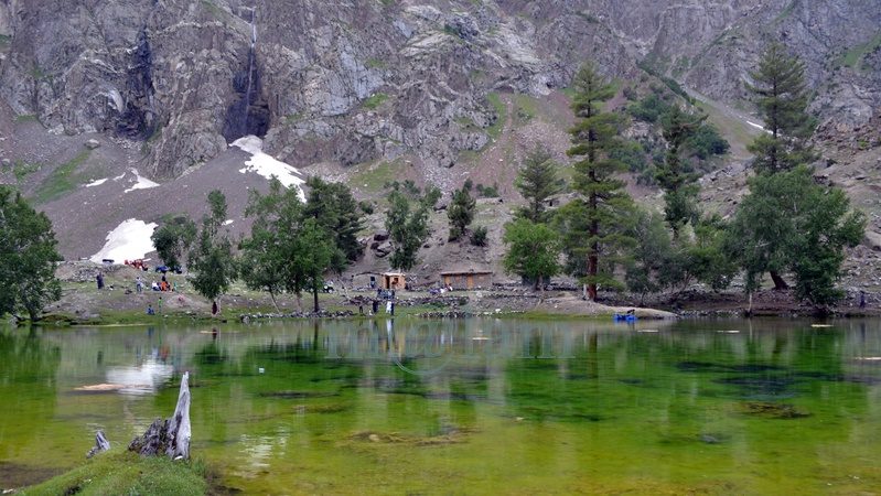
Unveiling the Beauty of Naltar Valley: A Hidden Gem in Gilgit-Baltistan Nestled majestically amidst towering mountains at an astonishing elevation of approximately 15,000 feet lies the picturesque Naltar Valley, a true jewel near the town of Gilgit in the Gilgit-Baltistan region of Pakistan. This idyllic highland boasts the dual distinction of being a perfect summer escape and a world-renowned winter ski resort, attracting both national and international skiing enthusiasts year after year. Enveloped in lush greenery, adorned with pine, spruce, birch, rowan, and juniper trees, and cradled by emerald hills and snow-capped peaks, Naltar Valley is not only a natural wonder but also home to the Gujjar tribe, renowned for cultivating delectable and oversized potatoes. Exploring Naltar Valley: Geography and Accessibility Located approximately 19 kilometers uphill from the Nomal Valley, which serves as a base and is situated at the mouth of the gorge, Naltar Valley is easily accessible. The Nomal Valley itself is a mere 20-kilometer drive from Gilgit via the western bank of the Hunza River and about 70 kilometers from Hunza Valley, accessible via the Karakoram Highway, passing through Rahimabad and crossing a sturdy concrete bridge over the Hunza River. To reach Upper Naltar (Naltar Bala or Ajeeni Naltar in the local Shina language) from Gilgit takes approximately 2.5 hours, while the journey from Hunza extends to around 4 hours. A Haven for Travelers: Tourist Attractions in Naltar Valley Naltar Valley is a haven for those seeking respite from the urban hustle and bustle or yearning for unadulterated serenity. Whether you plan a day trip or opt for an overnight stay, the valley offers various accommodation options, including the possibility of camping. Key attractions in the area include: 1. Skiing Naltar has firmly established itself as a premier winter sports destination, hosting international ski competitions. Due to its elevated location, Naltar receives a substantial amount of snow each year, making it perfect for skiing. The Ski Federation of Pakistan operates ski lifts, and every February, the valley becomes a magnet for national and international athletes. 2. Trekking Routes Naltar Valley serves as the starting point for two enchanting medium-level treks: one leading to the Naltar Pass (approximately 4,600 meters) towards the east, connecting to the Ishkoman Valley, and the other traversing the Daintar Pass (4,636 meters) westward to Chalt. A two-hour drive spanning approximately 47 kilometers from Gilgit along the western bank of the Hunza River brings you to Nomal Village, your gateway to these exciting treks. 3. Lakes The journey from Upper Naltar to the lakes covers about 13 kilometers of jeep-able road. However, when the road is impassable or washed away, a scenic walking trail opens up. These hikes take several hours on foot depending on the condition. This rugged jeep track runs alongside a rivulet, leading you to the captivating Bashkiri Lake – I, Bashkiri Lake – II, and Bashkiri Lake – III, nestled closely together at the gorge’s end. Locally, these lakes are known as “Chimo Bari (Fish Lake),” “Chakar Bari (Multi Ends Lake),” and “Bodolok Bari (Turbid Lake).” These lakes are ensconced within dense pine forests. Winters bring harsh conditions and sometimes pile up to 10 to 15 feet of snow. Summers attract hordes of local and international tourists and trekkers eager to explore this natural wonder. 4. Rivulet Glacial waters originating near the Wakhan Corridor’s border converge to form a rivulet that meanders through the gorge’s heart until it meets the Hunza River. This natural watercourse provides opportunities for activities like camping, cooking, and irrigation. These various enjoyable activities along its pristine banks, enhance the overall visitor experience. 5. Camping and Outdoor Activities Naltar Valley boasts numerous camping sites, making it ideal for overnight or weekend camping adventures. The valley’s safety and availability of fresh vegetables at reasonable prices ensure a comfortable and enjoyable stay. The hiking trails leading to breathtaking viewpoints along with its magnificent medium-range mountains, provide ample opportunities for exploration. Naltar is also famous for its diverse flora and fauna. The Weather in Naltar Valley Naltar Valley enjoys perpetually romantic weather. Even during the peak of summer, the lakeside at Naltar experiences frequent light showers, adding to the area’s allure. The ever-changing romantic weather, combined with the stunning natural scenery, makes a visit to Naltar Valley an unforgettable experience. Culinary Delights Light refreshments like tea and cookies are available for tourists at the lakeside. However, visitors planning to spend an entire day at Naltar are advised to make personal meal arrangements. Accessing Naltar Valley Please note that the new road to the Naltar Valley is under construction and accessible solely by 4WD Jeeps. Transport and camping arrangements for overnight in tents, are available for your convenience.
Naltar Valley Read Post »

, , , , , , , , , , , , , , , , , ,
The Karakoram Highway
Blogs, Gilgit-Baltistan, Roads & Highways

The Karakoram Highway

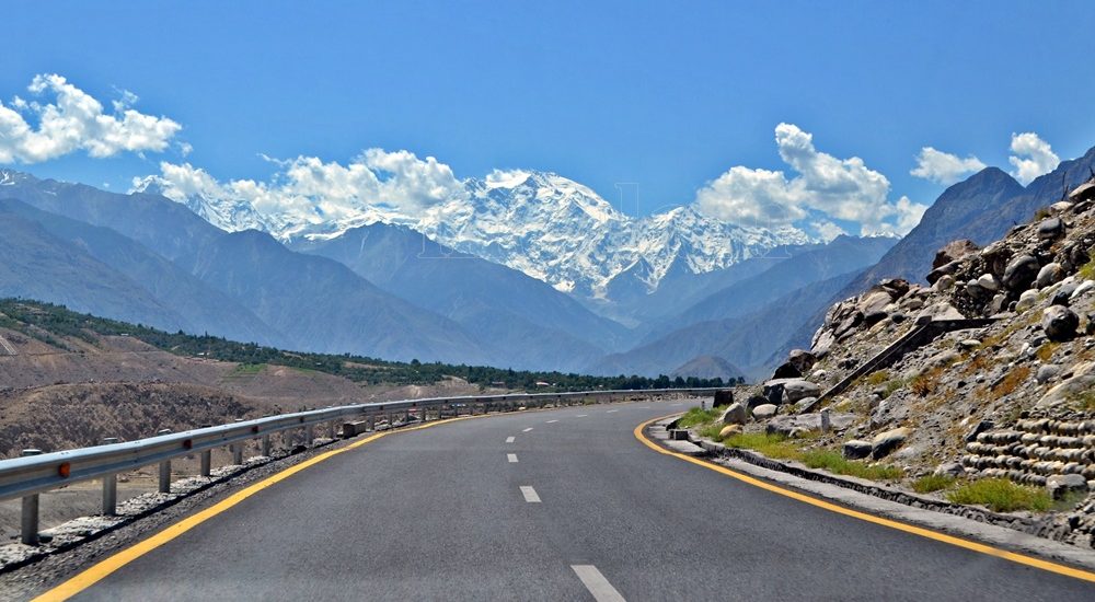
Exploring the Karakoram Highway: A Journey Through History and Scenic Beauty The Karakoram Highway (KKH) stands as a testament to human determination and engineering feats. It connects China and Pakistan via the Khunjerab Pass, situated at an awe-inspiring altitude of 4,733 meters. This epic roadway is not just a trade artery but also a legendary tourist attraction. It offers a captivating blend of historic landmarks, cultural diversity, and breathtaking natural beauty. For adventure enthusiasts, embarking on a journey along the KKH is an absolute thrill. Traversing Pakistan’s Section: A Scenic Odyssey The KKH adventure begins in Hasanabdal, Punjab, Pakistan. It stretches across an impressive 887 kilometers until it reaches the Khunjerab Pass at the Pak-China border. Along this route, the highway meanders through the rugged terrain of Khyber Pakhtunkhwa (KPK). It then follows the course of the Indus River and gracefully navigates the Karakoram and Pamir Mountains. Eventually, it meets the Chinese segment at Khunjerab Pass. In China, this remarkable highway is known as the Friendship Highway. Due to the harsh conditions it was built, it is sometimes referred to as the “Eighth Wonder of the World.” Unveiling the Route: A Glimpse into the Length The total length of the Karakoram Highway spans approximately 1,300 kilometers, with 887 kilometers in Pakistan and 413 kilometers in China. While the new route doesn’t exactly replicate the ancient Silk Route, it closely follows the same region, reviving the spirit of this historic trade network. The construction of the KKH came at a significant human cost, with both Pakistani and Chinese laborers toiling relentlessly to complete each kilometer of this ambitious project. Chinese workers who lost their lives during construction are honored at the Chinese cemetery, China Yadgar, in Danyore near Gilgit. Historic Roots: A Glimpse into the Past Historically, the Karakoram Highway was a vital caravan trail, serving as one of the branches of the ancient Silk Route. Over centuries, traders, pilgrims, warriors, and common folk traversed this route, ushering in profound changes in the social, cultural, and economic aspects of the region. The Saga of Construction: Overcoming Challenges Before the Karakoram Highway was built, the northern areas, now known as Gilgit-Baltistan, attracted the interest of the Russians, Chinese, and British, owing to its strategic significance. However, access to the region was a formidable challenge. In the 1800s, the British, who were in power, aimed to bolster their authority by constructing an all-weather communication infrastructure along the Indus. Realizing this vision was no small feat. Initially, the British improved an old Srinagar foot track, transforming it into a mule track. Later, a seasonal passage was established through Chilas, crossing the Babusar Pass to connect to the Kaghan Valley. Unfortunately, this passage remained open for only about six months a year during the summer. Following the partition of the subcontinent in 1947, the Srinagar road was permanently blocked. This period saw the northern areas divided into several states under local rulers. In 1958, the Indus Valley Road (IVR) project was conceived to create an all-weather road link between Swat and Gilgit. Construction commenced in 1959 as a joint venture between the two governments. Then, in 1966, a Sino-Pak agreement transformed the IVR into the Karakoram Highway. Despite financial constraints and the outbreak of the war between Pakistan and India in 1971, China’s invaluable support enabled the project to continue. Originally planned to stretch from Thakot to the Khunjerab Pass, the entrance point was later shifted to Hasan Abdal, and the project was completed in 1979. The highway was finally opened to the public in 1986. During construction, approximately 800 Pakistanis and 200 Chinese workers lost their lives, primarily due to landslides. Unofficial estimates suggest an even higher toll. The Chinese workers were laid to rest at the Chinese Graveyard in Danyore near Gilgit. A Path to Reconstruction: Upgrading the KKH In June 2006, Pakistan’s National Highway Authority (NHA) and China Road and Bridge Corporation (CRBC) signed an MoU to upgrade the KKH, expanding its overall width from 10 to 30 meters. This expansion aimed to accommodate heavy-duty vehicles, even in extreme weather conditions. Although construction took place, the width remained largely unchanged from the original design. During the construction phase, a significant event occurred on January 4, 2010, known as the Attabad incident. A massive landslide in the Attabad valley of Hunza damaged a section of the highway, creating a 23-kilometer-long lake and disrupting travel along the Karakoram Highway. To restore the road link between Pakistan and China, the construction of tunnels along a revised 24-kilometer route began in July 2012 and was completed in September 2015. This realigned route featured five tunnels and a bridge, rejuvenating the connection between the two countries. The Geopolitical Significance: A Strategic Artery The Karakoram Highway traverses a region marked by towering mountains and geological complexities, where China, Tajikistan, Afghanistan, and Pakistan converge within a 250-kilometer radius. Due to the intricate Kashmir conflict between India and Pakistan, the KKH holds strategic and military importance for these nations, especially Pakistan and China. Beyond geopolitics, the Karakoram Highway has significantly bolstered trade and tourism between Pakistan and China. The construction of the highway resulted in uplifting the living standards of the local population. The China-Pakistan Economic Corridor (CPEC) is set to bring substantial economic gains to the region, with plans to connect the Karakoram Highway to the southern port of Gwadar in Balochistan through the Chinese-aided Gwadar-Dalbandin railway, extending to Rawalpindi. Discovering Tourist Gems: Treasures Along the KKH The Karakoram Highway has earned international acclaim as a niche adventure tourism destination. Beginning in Hasan Abdal, about 50 kilometers from Rawalpindi city, this dual-carriage asphalt ribbon departs from the dusty plains of Punjab, embarking on a journey through the lower Himalayas of Hazara district. As it heads north, it winds through numerous captivating natural and historic sites, ultimately reaching the Pakistan section’s culmination at the Khunjerab border in the upper Hunza valley. This 887-kilometer stretch of the Karakoram Highway in Pakistan is a diverse tapestry of tourist attractions. From the

The Karakoram Highway Read Post »

, , , , , , , , , , , , , , ,
Passu Cathedral
Gilgit-Baltistan, Mountains

Passu Cones

Passu Cones: A Natural Wonder in Pakistan’s Karakoram Range Hidden in the grandeur of Pakistan’s Karakoram Mountain Range, the Passu Cones offer an unforgettable sight. These jagged, cathedral-like peaks, situated north of the serene Passu Valley and across the Hunza River, rise dramatically into the sky. Renowned for their distinctive shape, these spires have become one of the most iconic and photographed landscapes in the Gilgit-Baltistan region, showcasing the untamed beauty of Pakistan’s northern terrain. The Mystique of Passu The origins of the name “Passu” remain a mystery, but the region itself is a treasure trove of natural and cultural attractions. Visitors can explore the charming Passu Village, marvel at the icy grandeur of the Passu Glacier, admire the soaring Passu Peak, or gaze at the famed Passu Cathedral. All of these wonders are easily visible from the legendary Karakoram Highway (KKH), making the journey as memorable as the destination. Where Are the Passu Cones? The Passu Cones are located near Passu Village, approximately halfway between Gilgit and the Khunjerab Pass, the border crossing between Pakistan and China. Situated about 50 km from Karimabad and 150 km from Gilgit, they are part of the Batura Muztagh Range within the Karakoram system, one of the world’s most challenging and awe-inspiring mountain ranges. Locally known as Tupopdan, these peaks are also referred to as the Passu Cathedral or Cathedral Spires. They first captured international attention when British mountaineers scaled them in 1987, further enhancing their mystique and allure. What Makes Passu Cones Unique? The Passu Cones are celebrated for their dramatic, pyramid-like structure, which creates a stunning silhouette against the sky. Standing at an elevation of 6,106 meters (20,033 feet), they form a striking backdrop to the lush valleys and the tranquil Hunza River below. Unlike many remote peaks in the region, the Passu Cones are easily accessible from the Karakoram Highway, making them an ideal destination for travelers of all levels. Their ability to reflect light at sunrise and sunset creates a mesmerizing display of colors, from golden hues to deep shadows, captivating visitors and photographers alike. Captivating Beauty of Passu Cones The Passu Cathedral is perhaps the most recognizable feature of the Passu Valley. Soaring nearly four kilometers from its base, this pyramid-like peak is a testament to the raw power of nature. As the day begins, the first rays of sunlight illuminate the cones’ jagged edges, casting a play of light and shadow across their surface. During winter, the peaks become cloaked in snow, adding a pristine white brilliance to their already majestic presence. At sunset, the peaks glow with golden and bronze hues, offering an unforgettable visual treat for spectators. Getting to Passu Cones By Road: From Gilgit, take the Karakoram Highway toward Hunza. Public buses and private vehicles are readily available. By Road: From China, take the Karakoram Highway toward Hunza via Khunjerab Pass. Public buses and private vehicles are readily available from Tashkurghan. By Air: Fly to Gilgit from Islamabad and continue by road to the Hunza Valley. Tips for Visitors Stay hydrated and be mindful of altitude changes. Wear sturdy shoes, especially if you plan to trek. Respect the customs and traditions of the local community. Bring a camera—every moment at the Passu Cones is worth capturing. Why Visit Passu Cones? The Passu Cones epitomize the wild beauty of northern Pakistan, offering an experience that is both awe-inspiring and deeply moving. Whether you’re chasing adventure, capturing stunning photographs, or simply soaking in the serenity of nature, the Passu Cones promise memories that will last a lifetime. Best Time to Visit The ideal time to visit the Passu Cones is between April and October, when the weather is pleasant, and the natural surroundings are at their most vibrant. Spring and autumn are particularly stunning, with blooming flowers and colorful foliage. Winter brings a magical, snow-covered charm but can make road access more challenging. Nearest Attractions Passu Glacier Hussaini Suspension Bridge Borith Lake Batura Glacier Borith Lake Afsang View Point Ondra Poygah Attabad Lake Haldikish Yak Grill Rainbow Bridge Khunjerab Pass

Passu Cones Read Post »

, , , , , , , , , , , , , , , ,
Scroll to Top