Gilgit-Baltistan

Biddulph House & Library Gilgit
Others

Biddulph House & Library

Exploring the Rich Heritage of Gilgit: The Fascinating Biddulph House & Library Gilgit, a mesmerizing region in Pakistan’s Gilgit-Baltistan, boasts a historical landmark that narrates a captivating tale of cultural exchange and architectural marvel. Meet the renowned Biddulph House & Library, named after the esteemed British officer, Colonel Sir Neville Biddulph, who served in this very region during the late 19th century. Unveiling Biddulph House: A Fusion of British and Local Design Biddulph House, a true architectural gem, showcases a captivating blend of British and local design influences. Constructed in the late 19th century, this splendid abode served as the residence of Colonel Biddulph during his tenure in the region. The house’s distinctive Victorian-style architecture leaves visitors in awe, featuring intricate woodwork, spacious rooms, and a lush garden enveloping the property. The Enchanting Biddulph Library: A Treasure Trove of Knowledge Adjacent to the grand Biddulph House stands the equally impressive Biddulph Library, a beacon of knowledge and history. Also established by Colonel Biddulph, the library houses an impressive collection of books, manuscripts, and historical documents. The breadth of subjects covered is vast, encompassing local history, culture, literature, and more. As a result, the Biddulph Library serves as a key spot for researchers, scholars, and enthusiasts eager to explore the rich heritage of Gilgit-Baltistan. From the Past to the Present: An Evolving Cultural Hub Over the years, the Biddulph House & Library has transformed into a cultural hub of immense importance. Initially, the library underwent a transition and became the Municipal Library in the 1970s. Recently, it underwent a remarkable renovation, courtesy of the GB Government and the Aga Khan Trust for Culture Pakistan. Today, it proudly stands as the Exhibition and Research Center, offering a delightful experience to all its visitors. A Glimpse into the Colonial-era Architecture The Exhibition and Research Center invites guests to take a step back in time, offering glimpses of colonial-era architecture. Through an extensive collection of photographs, visitors can immerse themselves in the region’s rich history. The images capture historical buildings, places, and celebrated personalities from various fields. The center serves as a captivating time machine, attracting both tourists and locals alike, providing a serene and intellectually stimulating environment. A Testament to Cultural Exchange and Historical Significance Today, the Biddulph House & Library stands tall, symbolizing the region’s historical significance and the remarkable cultural exchange between the British and the local communities. Its grand presence serves as a poignant reminder of the past while encouraging an exploration of the unique heritage of Gilgit and its surrounding areas. For history enthusiasts, culture aficionados, and architecture admirers, the Biddulph House & Library is an absolute must-visit destination. Immerse yourself in the captivating blend of British and local design, delve into the treasure trove of knowledge at the Biddulph Library, and relish the sights of colonial-era architecture at the Exhibition and Research Center. The experience promises to be truly enriching and memorable, leaving you with a profound appreciation for the heritage of Gilgit and its enduring cultural legacy.

Biddulph House & Library Read Post »

, , ,
British-Cemetery-Gilgit
City Breaks, Gilgit-Baltistan, Tombs

British Cemetery Gilgit

British Cemetery in Gilgit: A Testament to Colonial Legacy Nestled in the breathtaking landscapes of Gilgit, the capital of Gilgit-Baltistan, the British Cemetery, also known as G.W. Hayward Cemetery, stands as a poignant reminder of the region’s colonial past. This serene burial ground not only reflects the legacy of the British Raj’s presence in the Gilgit Agency during the 19th and 20th centuries but also offers visitors a glimpse into the historical and cultural tapestry of the era. Commemorating George W. Hayward The British Cemetery was initially named “Hayward’s Garden” in honor of George W. Hayward, a distinguished British explorer. On July 18, 1870, Hayward became the cemetery’s first internee after being tragically assassinated near Darkot Pass in Ghizer. The Royal Geographical Society of London established his burial site, marked with an inscription commemorating his gallantry and achievements. Hayward’s legacy as an intrepid traveler exploring the Pamir grasslands is immortalized here. Architectural Highlights Encircled by a robust stone wall and featuring ornate wrought iron gates, the British Cemetery Gilgit showcases the architectural finesse of the Victorian era. The grave markers, crafted predominantly from stone, are adorned with delicate engravings and intricate designs, making them artistic marvels in their own right. A Historical Landmark Along the Silk Road Situated along the historic Silk Road, Gilgit was a pivotal hub for trade and administration during the British colonial era. The cemetery was established as a final resting place for British officials, soldiers, travelers, and locals who collaborated with the British in various capacities. Each grave tells a story of courage, exploration, and the intertwined destinies of British and local communities. Notable Figures Buried in the Cemetery The cemetery is home to at least 18 graves of notable individuals who played significant roles during the British era, including: Captain G.W. Hayward: The cemetery’s first occupant, renowned for his exploration of Central Asia. Major William Brown: A prominent figure in the development of the Gilgit Agency. Arthur Francis Bruce: The political agent of Gilgit from 1906 to 1908. Henry Gordon Bell: Political agent of Gilgit, interred on July 25, 1912. Harold S. Eldred: Of the Sikh Pioneers Kashmir Infantry, who tragically drowned in the Indus River in 1929. Additionally, the cemetery contains the graves of travelers and mountaineers, including: Members of the 1959 Batura Muztagh Expedition: Dr. Keith Warburton, Harry G. Stephenson, Richard S. Knight, Martin Guennel, and Albert Hirschbichler. Major Jimmy Mills: Who perished during the Pakistan-British Army Karakoram Expedition. Preserving History and Promoting Tourism The British Cemetery in Gilgit is a treasure trove for history enthusiasts and researchers eager to explore the colonial legacy of the region. Its unique architectural style, coupled with the significant individuals interred within its grounds, makes it a compelling destination for cultural tourism. Efforts to conserve and restore the cemetery have been spearheaded by local authorities and heritage organizations. Restoration work focuses on maintaining the structural integrity of grave markers, repairing damaged monuments, and ensuring the cemetery remains a tranquil space for reflection. Visitor Information Open to the public, the British Cemetery offers visitors a chance to delve into the past while paying their respects to those laid to rest. While guided tours are not officially available, local experts often provide valuable historical insights upon request. Visitors are welcome to take photographs but are reminded to respect the solemnity of the site. A Journey Through Time Visiting the British Cemetery in Gilgit is more than a historical excursion; it is an opportunity to honor the individuals who shaped the region’s history and appreciate the cultural exchange between the British and local communities. As restoration efforts continue, this historic site stands as a cherished monument, attracting travelers and history aficionados from around the globe. Nearby Attractions: Konodas Suspension Bridge Biddulph House & Library Karga Buddha Hanzel Stupa Agortham Boulder Uprising Memorial Gilgit Konodas Rock Carvings Danyore Suspension Bridge Danyore Rock Inscription Chinese Graveyard Danyore The Victory Monument of Taj Mughal

British Cemetery Gilgit Read Post »

, , , , , , , , , ,
Here the great mountain ranges of the Karakoram, Hindukush, and Himalaya converge
Gilgit-Baltistan

Junction Point of Three Mountain Ranges

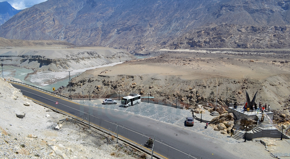
Unlocking the Secrets of the “Junction Point” of Three Majestic Mountain Ranges If you’re a true adventurer and nature enthusiast, there’s a hidden gem near Jaglot, just 40 kilometers southeast of Gilgit, Pakistan, that you absolutely must explore. It’s the awe-inspiring convergence of three of the world’s most famous mountain ranges: the Karakoram (known for its black gravel), the Himalaya (home of perpetual snow), and the Hindukush (aptly named the “killer of Hindus”). This unique location is often referred to as the “Junction Point of the world’s three great mountain ranges.” What’s more, this exceptional site also marks the meeting of the Gilgit and Indus Rivers, and the starting point of the Skardu road branching off from the Karakoram Highway (KKH). Geographic Significance: Where Worlds Collide The Junction Point isn’t just significant locally; it holds a unique place on the global stage. Pakistan is the only country where these three renowned mountain ranges converge, each boasting its highest peaks. Nanga Parbat, K-2, and Terich Mir are the standout peaks in the Himalayas, Karakoram, and Hindukush, respectively. These three ranges are considered sub-ranges of the mighty Himalayas, known as the trans-Himalayas. Standing at this point allows you to easily discern the direction of each mountain range. The Himalayan range lies to the south and east of the Indus River. The Karakoram range extends northeast from the Gilgit River, while to the west of the Gilgit and Indus Rivers, you’ll find the Hindu-Kush range. Exploring the Mountain Ranges: A Journey to Remember Karakoram Range: A World of Wonders The Karakoram Range, spanning approximately 500 kilometers, straddles the borders of Pakistan, India, and China. Within a radius of just 160 kilometers, it boasts the highest concentration of peaks soaring above 5,500 meters, numbering over 100. The crowning jewel of this range is K-2, the second-highest peak in the world, standing tall at 8,611 meters. The Karakoram is home to some of the planet’s longest glaciers, including Siachen, Batura, Baltoro, Biafo, Hisper, Gondogoro, and Chogolisa, making it one of the most heavily glaciated regions outside the Polar Regions. Himalayan Range: Nanga Parbat and Beyond The Himalayan range features Pakistan’s second-highest peak, Nanga Parbat, standing at an imposing 8,126 meters. Known as the “killer mountain” due to its formidable reputation, Nanga Parbat dominates the Astor District. The Great Himalayan Range stretches across 2,400 kilometers, encompassing Pakistan, Nepal, and India. Mount Everest, the world’s highest peak at 8,848 meters, calls Nepal home within this range. Hindu Kush Range: A Journey into History The Hindu Kush Range, spanning nearly 9,600 kilometers, is a land of its own wonders. While it primarily hosts smaller peaks, most standing below 7,500 meters, it covers the peaks of the Ghizer, Yasin, and Ishkoman valleys in Pakistan. The range reaches its zenith with Terich Mir, standing proudly at 7,708 meters in the district of Khyber Pakhtunkhwa. The Hindu Kush stretches from the Pamirs to Iran, offering a fascinating journey through history and geography. A Tourist’s Paradise: Unveiling the Junction Point A visit to this captivating site is a must for any traveler. It provides not only an educational experience but also a breathtaking panorama of the entire region, from the confluence of the Gilgit and Indus Rivers to the meeting of the three mighty mountain ranges. Local folklore weaves tales of the Junction Point being the residence of Jinns and fairies. Legend has it that these supernatural beings frequented the confluence of the rivers, using the waters for drinking and bathing. The Site: Your Gateway to Adventure An elevated platform, accessible by stairs, stands proudly on the edge of the Karakoram Highway. It offers a 360-degree view of the region and provides detailed information about the mountain coordinates. Adequate parking facilities are available for vehicles, and informative signboards offer essential information about the site. Regrettably, many, both within the country and from abroad, remain unaware of the significance of this captivating land. While some domestic tourists, particularly those traveling by public transport or passing by during odd hours or in the darkness, miss this gem, international tourists often include it as a vital stop on their itinerary. Best Time to Embark on Your Adventure The Karakoram Highway remains open year-round, allowing you to visit or pass by this unique site at any time of the year. However, the ideal time to explore Gilgit-Baltistan is from March to November, as the region’s winters can be harsh and freezing. Don’t miss the chance to stand at the crossroads of three remarkable mountain ranges, where nature’s grandeur knows no bounds. Visit Junction Point of Three Mountain Ranges, and let the magic of Pakistan’s unparalleled geography and history captivate your senses.

Junction Point of Three Mountain Ranges Read Post »

, , , , , , ,
Rakaposhi
Gilgit-Baltistan, Mountains

Rakaposhi

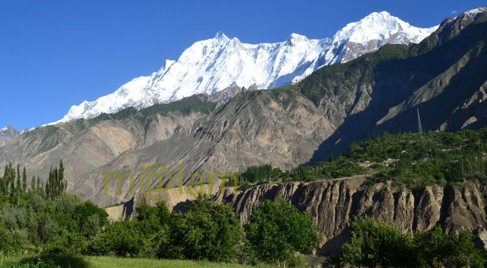
Unveiling the Magnificence of Rakaposhi: Pakistan’s Spectacular Mountain Rakaposhi is a renowned mountain peak nestled in the majestic Karakoram mountain range of Pakistan. It proudly graces the Nagar valley of Gilgit-Baltistan, flanked by the enchanting landscapes of Bagrot and Danyore. Standing tall as the 27th highest peak globally and holding the prestigious rank of being the 12th highest in Pakistan, Rakaposhi derives its name from the local vernacular, translating to “Snow Covered.” Locally, it is affectionately referred to as Bilchhar Dumani, signifying “Mother of Mist” or “Mother of Clouds.” A Breathtaking Encounter The journey to Rakaposhi’s awe-inspiring presence begins when one embarks on the Karakoram Highway (KKH) from Gilgit to Hunza. Opposite Kino Kutto, a rocky mountain aptly named in the local Shina language as “Black Knee” due to its shape, you are granted the first and most splendid glimpse of this majestic peak. While this spot is often referred to as the “Rakaposhi viewpoint,” the pinnacle of views lies in Ghulmet. Here, you are treated to a broader and more stunning panorama of Rakaposhi. The picturesque Jaffarabad village serves as a backdrop, marking your entry into the magical realm of the Hunza Valley. A Scenic Journey The scenic vistas of Rakaposhi continue to unfold as you journey along the Karakoram Highway, tracing your way through the Hunza Valley. However, if you opt to travel from the opposite side of the Hunza River, specifically through the lower Hunza or Shinaki valleys (including Khizr Abad, Hussainabad, Mayun, and Khanabad), you’ll be treated to captivating facets of Rakaposhi. The mountain reveals itself in all its glory, offering a different perspective on this natural wonder. To reach the Ghulmet viewpoint, situated approximately 5 km short of the main viewpoint, you can rejoin the Karakoram Highway. Ghulmet village, home to the famous viewpoint, lies roughly 75 km from Gilgit and is a favored vacation destination for travelers seeking Rakaposhi’s grandeur. An Unparalleled Ascent One of Rakaposhi’s most remarkable features is its astounding elevation gain of 5900 meters over a mere 11.2 kilometers of horizontal distance from the Hunza-Nagar River. It stands as the sole mountain peak worldwide that ascends directly from fertile cultivated fields. Rakaposhi’s distinction arises not merely from its rank but from the sheer magnificence it embodies. A Triumph in History The first successful ascent of Rakaposhi was achieved in 1958 by Mike Banks and Tom Patey, who undertook the challenging Southwest Spur/Ridge route. Their conquest, while awe-inspiring, came at the cost of minor frostbite. Tragically, another climber slipped and lost their life during the descent on that fateful night. A Sanctuary of Biodiversity The people of Nagar have dedicated the extended Rakaposhi Mountain region as a national park. It’s indeed a noble initiative inaugurated by the Minister for Northern Areas. This sanctuary is home to several endangered species. These include Marco Polo sheep, Snow Leopards, wolves, and a diverse array of wildlife. Rakaposhi’s natural beauty not only captivates the eye but also safeguards the precious biodiversity thriving within its vicinity. Rakaposhi stands not only as a symbol of natural wonder but also as a testament to human triumph and conservation efforts. Its allure continues to draw adventurers, nature enthusiasts, and conservationists. Additionally, this majestic mountain offers a profound connection with the splendor of the Karakoram mountain range. Besides, it boasts a rich tapestry of Pakistan’s natural heritage.

Rakaposhi Read Post »

, , , , , , , , , , , , , , , , ,
Rakaposhi View Point from the Karakoram Highway
Gilgit-Baltistan

Rakaposhi View Point

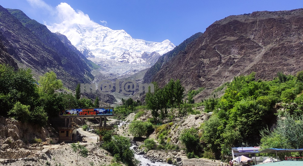
Rakaposhi View Point -A Close Encounter With The Shining Wall The Rakaposhi View Point undoubtedly stands as a testament to the unparalleled beauty of nature. The view point is situated in Ghulmet village, on the main Karakoram Highway, within the enchanting Nagar Valley. This extraordinary viewpoint offers an up-close and personal encounter with the awe-inspiring Rakaposhi mountain. Karakoram Highway: A Tapestry of Marvels The Karakoram Highway is much more than a mere asphalt artery connecting Pakistan and China through the Khunjerab Pass. It’s a highway especially adorned with a treasure trove of tourist attractions. The highway boasts natural wonders, archaeological marvels, cultural heritage, and architectural splendors. It beckons travelers to pause and immerse themselves in its allure. Rakaposhi View Point, nestled along this route, stands out as a prime exemplar of pristine natural beauty. An Oasis Amidst the Journey When traversing the road between Gilgit and Hunza, seasoned travelers always include a mandatory stop at Rakaposhi View Point. The shadow of Rakaposhi is the 27th highest peak globally, soaring at an elevation of 7,788 meters. Here one can find solace and delight in the lap of unparalelled natural grandeur. Moreover, the locale offers small terraces thoughtfully designed along the glacier-fed stream, inviting tourists to relish moments of relaxation, savor delicious meals, and capture stunning vistas. Summer Serenity: Immersing in Nature’s Bliss During the summer season, tourists revel in the joy of sitting by the stream, dipping their feet into the refreshing glacier water. Furthermore, this site is ideal for capturing the picturesque surroundings through their lenses. The symphony of flowing water, the verdant embrace of nature, and the grandeur of Rakaposhi provide an unforgettable experience. Evolution of Rakaposhi View Point The journey of Rakaposhi View Point from obscurity to acclaim has been nothing short of remarkable. The gradual surge in tourist footfall led to its growing prominence, which in turn catalyzed infrastructure development in the vicinity. The site boasts a plethora of attractions including the glacier nestled in greenery and the meandering stream driving a gentle breeze. In its nascent stage, Rakaposhi View Point was no more than a humble gift shop and a local eatery, primarily serving the needs of nearby travelers. Over time, local entrepreneurs embraced the opportunity, resulting in the establishment of gift shops, handicraft stores, convenience shops, restaurants, campsites, and even upscale tourist accommodations. A new road has been constructed, providing closer access to the glacier emanating from Rakaposhi, and work is underway to develop additional tourist attractions. The future holds the promise of turning this site into a premier tourist destination. Culinary Delights and More For travelers journeying between Gilgit and Hunza, Rakaposhi View Point stands as an ideal spot for a leisurely and sumptuous breakfast or an open-air lunch with breathtaking views. Not to be missed is the local specialty, “Chap-Shuro,” a unique kind of local pizza. The menu offers an array of fresh local cuisine at budget-friendly prices. Here, you can always count on delectable food coupled with personalized service. Rakaposhi View Point is not just a stopping point on your journey; it’s an invitation to immerse yourself in nature’s grandeur and indulge in local delights. Visit and be captivated by the magic of Rakaposhi and the wonders that surround it.

Rakaposhi View Point Read Post »

, , , , , , , , , , , , ,
Victory monument of Taj Mughal
Gilgit-Baltistan, Monuments

Victory Monument of Taj Mughal

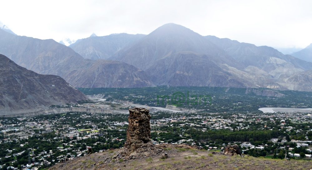
Exploring the Majestic Victory Monument of Taj Mughal Unveiling the Remarkable Tale of the 700-Year-Old Commemorative Tower in Gilgit, Pakistan Nestled gracefully upon the southern mountains of Gilgit town, Gilgit-Baltistan, Pakistan, stands the splendid Victory Monument of the Taj Mughal. Undoubtedly, the monument is a testament to history, triumph, and timeless beauty. With a history spanning over 700 years, this commemorative tower bears witness to the legacy of Taj-ud-Din Mughal. Taj-ud-Din was an Ismaili ruler from Badakhshan who graced Gilgit-Baltistan with his presence during the 13th century AD. Erected by his devoted soldiers, this monument stands tall at 21 feet and 10 inches, with a circumference of 14 feet and 4 inches, perpetuating the memory of his glorious victory. Journey to the Past: Unveiling the Monument’s Origin The Victory Monument of the Taj Mughal finds its sacred abode against the stunning backdrop of the southern mountains of Gilgit city. The Monument majestically sits about 1000 feet above Gilgit town. This awe-inspiring edifice not only oversees the enchanting villages of Gilgit and Danyore but also narrates a saga of victory and courage that continues to captivate the hearts of those who tread its path. Unveiling the Pathways: A Scenic Staircase Adventure Gone are the days of arduous treks and intricate routes. In order to promote history and tourism, access to the monument has been made easy. From the city center or the bus station, one can drive towards Serena Hotel in Jutial and follow the signboards leading to the hiking point. The monument is now reachable via a splendid flight of stairs, gracefully winding its way through rocky trails. These trails, adorned with the raw beauty of nature, create an immersive experience that heightens the anticipation of the forthcoming spectacle. As each step is taken, a sense of excitement and wonder builds, propelling us toward our destination. Cycle Track Marvel: A Gateway from Barmas to Jutial Adding to the allure of this journey is the newly constructed water channel Cycle Track, connecting Barmas to Jutial, Gilgit. One can do the monument from Barmas, the southern end of Gilgit, as well while enjoying the majestic views of Gilgit and surrounding valleys along the cycling trail. This ingeniously designed pathway presents an alternative route, one that promises a unique blend of adventure and tranquility. Unveiling the Monument’s Grandeur Architectural Resplendence: A Glimpse into the Monument’s Construction Erected upon the ridge of the Rocky Mountains, the Victory Monument stands as an embodiment of architectural finesse. Crafted meticulously with local stone and clay, this circular tower resonates with the echoes of a bygone era. Yet, the passage of time has not been without its effects, as the monument’s structural integrity slowly wanes, hinting at the ephemeral nature of existence. Temporary support has been tendered to its base, while the southern façade bears the marks of weathering, urging for a much-needed restoration. A Panoramic Tale: The Enchanting Vistas from the Monument’s Peak Gazing from the heights of the Victory Monument, one is rewarded with an awe-inspiring panorama that unfurls before the eyes. Gilgit town, stretching from Bagrot in the east to Baseen in the west, is caressed by the winding embrace of the Gilgit River. The tower, known as “Shikaari” in the local Shina language, offers an unobstructed view of the surrounding valleys, cradled by vigilant mountain sentinels. Embracing the Experience: Best Time & Route to Embark Packing Essentials: The Checklist for a Memorable Voyage The monument can be accessed at any time of the year. During peak summers, only early morning or late afternoon time is suggested to avoid heat. Preparation is the key to a fulfilling visit to the Victory Monument. As you tread upon the barren mountain terrain, remember to arm yourself with a water bottle, ensuring hydration amidst the arid landscape. Similarly, the scorching sun necessitates the application of sunburn cream, while sturdy shoes guarantee secure footing. Complete your ensemble with sunglasses, and a hat/cap, and equip yourself with a camera or cell phone to capture the moments that unfold. Embarking Beyond: Exploring Gilgit’s Treasures Beyond the resplendent Victory Monument, Gilgit extends an invitation to delve into its treasury of attractions. Venture into the embrace of ancient history as you encounter the 7th-century Karga Buddha, a silent sentinel of bygone times. In addition, Biddulph House, Hal Ga Naal, Hanzal Stupa, Gilgit Suspension Bridge, Chinar Bagh, Buddhist Rock Carvings, and the hiking track near KIU await your exploration. Each movement narrates a unique chapter in the tale of Gilgit’s legacy. Charting Your Course: Navigating to Gilgit Accessing Gilgit is a journey that intertwines with the thrill of the destination. Flights operate daily from Islamabad, weather permitting, offering a gateway to this realm of wonder. Likewise, roadways pave the way from Islamabad along the (Karakoram Highway) KKH and from Chitral via the Gilgit-Chitral road. While those journeying from Kashgar in China tread the path along the KKH—the months from May to mid-October emerge as the optimal time to embark on this odyssey. Capturing Memories: The Must-Have Essentials A pilgrimage to Gilgit demands thoughtful preparation. Ensure a water bottle accompanies you, quenching your thirst amid the landscapes. The embrace of the sun necessitates the shield of sunburn cream, while sturdy footwear guarantees steadfast steps. Moreover, bedecked with sunglasses and a hat, seize the moment with a camera or cell phone, encapsulating memories that endure. The Victory Monument of Taj Mughal stands as a living testament to a bygone era. It proudly stands as a beacon of triumph that graces the mountains of Gilgit. As you traverse the path to this historical marvel, let the vistas of Gilgit and the tales.

Victory Monument of Taj Mughal Read Post »

, , , , , , , , , , , ,
Shandur Polo Festival
Gilgit-Baltistan

Shandur Polo Festival

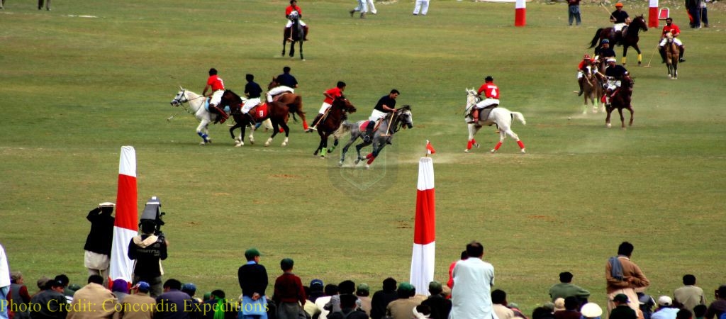
Exploring the Thrilling Shandur Polo Festival: A Unique Experience at 3734m Altitude The exhilarating Shandur Polo Festival unfolds at the awe-inspiring Shandur polo ground, nestled at a breathtaking altitude of 3734 meters. This remarkable event occurs on the border shared by the Chitral district of Khyber Pakhtunkhwa (KPK) and the Ghizer district of Gilgit-Baltistan in Pakistan. The festival takes place annually from the 7th to the 9th of July. This festival captivates thousands of enthusiastic spectators, drawing them into the world of the kings’ game – traditional freestyle Polo. A Unique Polo Experience The version of the Polo showcased during the Shandur Polo Festival is distinctive to this region. It offers an experience unparalleled anywhere else in the world. For three exhilarating days, domestic and international tourists, ardent supporters from Gilgit and Chitral, organizers, vendors, performers, Polo players, and their magnificent horses come together to create a vibrant makeshift village. The verdant Shandur Pass serves as a spectacular battleground during this festival. The World’s Highest Polo Ground The Shandur Polo Ground is renowned as the world’s highest Polo ground. It is encircled by majestic mountain peaks and graced with a serene lake in the backdrop. This breathtaking setting not only enhances the festival’s allure but also provides exciting activities for tourists. The Polo ground, situated in the heart of the pass, measures 200 meters by 56 meters, enclosed by a 60-centimeter-high stone wall. The size of the ground is in contrast to the conventional Polo field’s dimensions of 270 meters by 150 meters. This smaller size adds to the intensity of the game, making it seem crowded for the 12 players who compete at any given time. However, this limitation prevents the horses from extended gallops at such high altitudes. A Glimpse into History Polo’s roots trace back to the 6th century BC when it served as a training game for cavalry units of the king’s guards and elite troops in Persia. Originally, Polo boasted up to 100 players on each side, resembling a mini-battle. In the 6th century AD, it became Persia’s national sport and gradually spread to Arabia, Tibet, and China. Tragically, in 910, a game in China led to the death of a cherished relative of Emperor Apao Chi, prompting the gruesome beheading of all players. In South Asia, Polo arrived in the 13th century, introduced by Muslim conquerors. Over time, it evolved into a more regulated version from its wild beginnings. The contemporary Polo we witness today typically features six players on each side with a distinct lack of rigid rules. The free-style polo is epitomized by the famous saying, “The rule is that there is no rule.” However, the polo festival at Shandur makes one exception, with six players on each side engaging in an intense one-hour match, punctuated by a mere 10-minute break due to the high altitude. This breather comes alive with a traditional dance performance, and the team securing the most goals within the allotted time emerges victorious. Historical Beginnings Shandur’s first Polo match occurred in 1936. It was initiated dramatically by Major Evelyn Hey Cobb, the British political agent of the region. Cobb, a Polo enthusiast, ordered Niat Qabool Hayat Kakakhel, a prominent figure, and assistant to the governor from Ghizer district, to construct a Polo Ground in Shandur. This Polo Ground earned the name “Mas Junali,” derived from two Khuwar languages, meaning “Moony Polo Ground.” Impressed by Kakakhel’s efforts, Cobb sought to reward him However, Kakakhel declined and instead asked for trout to be stocked in local streams. Cobb agreed, importing live trout from England, which were released into the River of Ghizer. This visionary move paved the way for the Directorate of Fisheries and job opportunities in the region. Today, Gilgit-Baltistan is also renowned for Trout fishing. Preparing for Battle Players and horses from both sides arrive at Shandur weeks before the grand showdown to acclimatize to the high altitude. Preliminary matches in both Chitral and Gilgit determine the best horses and players for the final games, with local judges making their selections during test matches on home grounds. A Wild Game Safety measures take a back seat during this wild game. Players rarely wear helmets, donning colorful attire and wielding strapless mallets as they chase the ball vigorously on their horses, often without bandages to protect the steeds from harm. Winning the highly anticipated trophy is a source of immense pride for both teams, making national headlines. Supporters and tourists flock to the venue as soon as the rival teams and their horses make their grand entrance. Access Both Gilgit and Chitral districts are accessible by air and road from the capital city of Islamabad. Shandur is approximately 211 kilometers west of Gilgit via the Gilgit-Chitral road. Conversely, it is about 168 kilometers northeast of Chitral along the Shandur-Gilgit road. The journey from Gilgit treats travelers to breathtaking vistas of valleys, lakes, fruit orchards, traditional houses, terraced fields, flowing rivers, and serene springs. Similarly, the drive from Chitral offers glimpses of the Mastuj and Surlasp valleys’ lush natural beauty, the warm hospitality of the residents, and traditional houses nestled amidst stunning landscapes. Both routes are suitable for 4WD vehicles but are closed during the winter months. Activities The heart-pounding Polo matches at Shandur are complemented by an array of activities. These warm-up activities help visitors to immerse themselves in the natural and cultural beauty of the region. Adventure enthusiasts can explore the surroundings of Shandur, try their hand at stream and lake fishing, or embark on exhilarating hikes. The event also provides a fascinating glimpse into the lifestyle and cultural traditions of the people of Gilgit and Chitral. Nights come alive with musical performances and fireworks, while daytime showcases paragliding and traditional dances from Chitral and Gilgit-Baltistan. The indigenous customs and natural beauty are a visual delight for visitors. Plan Your Visit For all visitors, it is highly recommended to: Arrive at the venue at least a day before the final contest to fully savor the festival.

Shandur Polo Festival Read Post »

, , , , , , , , , , , , , ,
Phander Valley
Gilgit-Baltistan

Phander Valley

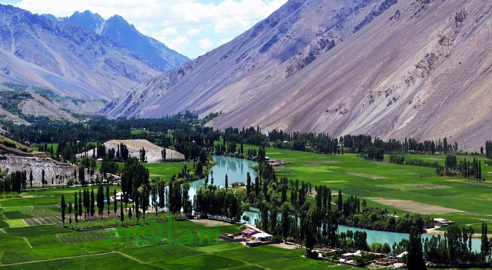
Unveiling the Enchanting Beauty of Phander Valley: A Nature Lover’s Paradise Nestled in the heart of the Ghizer District of Gilgit-Baltistan in Pakistan lies the breathtaking Phander Valley. This hidden gem is renowned for its unrivaled grandeur and sheer natural beauty. What truly sets this valley apart is, in fact, its remarkable display of diverse colors, changing with the seasons. Moreover, the tranquil deep blue rivulet gracefully meandering through the valley’s center adds to the enchantment, creating a scene straight out of a dream. Exploring Phander’s Geography Phander finds its home in the Gupis Valley of Ghizer district, within the mesmerizing Gilgit-Baltistan region. Ghizer district shares its borders with Gilgit District to the east, Hunza-Nagar to the northeast, Diamer to the south, and Chitral district of Khyber Pakhtunkhwa to the west. A Journey Through Nature’s Masterpiece As you embark on a journey through the Ghizer District towards the Shandur Pass, you’ll be greeted by a series of tiny valleys nestled along the Gilgit River. The landscape here is undoubtedly a testament to nature’s creativity, stretching from Gilgit to Lunger near Shandur. Each stretch leading up to Lunger boasts traditional houses surrounded by lush gardens, bountiful fruit orchards, and meticulously terraced fields. Attractions Along the Way The road to Phander Valley is adorned with numerous attractions that promise an enjoyable journey without the slightest hint of fatigue. As your eyes feast on the vibrant green fields, enchanting fruit orchards and gardens, pristine lakes like Khalti Lake and Phander Lake, and the sky-blue river flowing gracefully between valleys connected by suspension bridges, you’ll find yourself immersed in a unique and awe-inspiring experience. Likewise, the clear glacial waters and natural springs that dot the landscape further add to the visual delight. A Mosaic of Cultures Beyond its diverse landscape, Ghizer District boasts a rich tapestry of cultures that make it even more enticing. The residents here speak a multitude of languages, including Shina, Khuwar, Burushaski, and Wakhi, depending on the region. These diverse cultures coexist harmoniously, and the warm and welcoming locals lead simple lives, sustaining themselves primarily through agriculture. The Pinnacle of Scenic Beauty While the entire district is a visual treat, the Phander Valley stands out as a heavenly masterpiece. This bowl-shaped valley is formed by a natural barricade at its eastern end, where the PTDC Motel overlooks the breathtaking Phander Lake. Additionally, a government rest house perched on a ridge offers panoramic views of both the valley and the lake. A Nature Lover’s Paradise Phander Valley boasts a natural setting that is truly one-of-a-kind. Lush plains cover the valley’s base, separated by the calm, deep blue waters gently flowing downstream. These waters further teem with trout, a regional delicacy that every tourist should savor. Easy Access to Paradise Phander is conveniently located approximately 173 kilometers west of Gilgit town, making it easily accessible. The journey typically takes around five hours, depending on the pace. The Gilgit-Chitral road is undergoing reconstruction currently. Upon completion, the journey will be reduced to about 3 hours. For those traveling via Chitral, Phander can also be reached via the scenic Shandur Pass. Phander Valley is a testament to the splendor of nature, offering a harmonious blend of diverse landscapes, rich cultures, and serene beauty. Whether you’re an adventure seeker or a nature enthusiast, this enchanting valley promises an unforgettable experience that will leave you in awe of the natural world’s wonders.

Phander Valley Read Post »

, , , , , , , , , , , , ,
Key Facts about Pakistan
Blogs

Pakistan

Exploring Pakistan: A Treasure Trove of Diverse Experiences Pakistan stands as an exceptional and blessed nation, graced with some of Asia’s most breathtaking landscapes. Its geography is as varied as its rich cultures, and its people are known for their warm hospitality. In the realm of discovering the roots of modern-day humanity, few places on Earth rival Pakistan. Unraveling the Tapestry of History The land that now comprises Pakistan has been a cradle of ancient civilizations and a melting pot of cultures and dynasties for centuries. From the ancient Neolithic Mehergarh civilization, dating back 9000 years, to the illustrious 5000-year-old bronze age Indus Valley Civilization, the 3000-year-old Buddhist Gandhara Civilization, the opulent Mughal Era of the 16th century, the brief Sikh rule, to over two centuries of British occupation, leading to independence in 1947, Pakistan’s history is a tapestry of unparalleled events, unlike any other sovereign state. A Glimpse of Pakistan’s Geography Officially, the country is known as the Islamic Republic of Pakistan. Most importantly, Pakistan ranks as the 6th most populous nation in South Asia. Altogether, the country houses over 224 million people from diverse cultural and ethnic backgrounds. Encompassing 881,913 square kilometers (340,509 square miles), Pakistan boasts four provinces – Sindh, Baluchistan, Punjab, and Khyber Pakhtunkhwa – and three territories – Islamabad, Kashmir, and Gilgit-Baltistan. The carefully planned capital city, Islamabad, lies at the heart of this diverse nation. Pakistan’s strategic location at the crossroads of Asia divides it into three major geographic regions: the northern highlands, the Indus River plains, and the Balochistan Plateau. Bordered by the Arabian Sea’s 1046-kilometer coastline in the south, India to the east, China to the northeast, Afghanistan to the northwest, and Iran to the southeast, Pakistan’s diverse landscape includes glaciated mountain ranges in the north (Gilgit-Baltistan), fertile alluvial plains, expansive deserts, lush forests, plateaus, jungles, diverse flora and fauna, meandering rivers, and pristine lakes. A Bounty of Tourist Attractions Pakistan is a treasure trove of tourist attractions, each region offering a unique experience. Northern Adventures The northern mountainous regions encompass parts of KPK (Chitral, Swat, and the Kaghan Valley), Azad  Kashmir, and all of Gilgit-Baltistan. Altogether, the region forms the westernmost edge of the magnificent Himalayas. This area is a haven for adventure enthusiasts offering opportunities for trekking and mountaineering. Moreover, climbing, white-water rafting, mountain and desert jeep safaris, and paragliding are other activities adventurers can take up. Gilgit-Baltistan is proud to host the world’s highest mountains and longest glaciers outside the polar regions. The region undoubtedly makes it a magnet for adventurers. This region also marks the convergence of three mighty mountain ranges – the Karakoram, the Hindukush, and the Himalaya – along with the Pamir mountain range. It was once a vital trade route of the ancient Silk Route. Now, it is embodied by the Karakoram Highway, connecting Pakistan and China at Khunjerab Pass. This highway is adorned with over 100,000 petroglyphs and rock carvings, testifying to its rich Buddhist history. The region’s towering mountains, quaint valleys, terraced fields, ancient forts showcasing architectural marvels, and a history spanning centuries beckon travelers. Central Treasures Pakistan’s central regions feature dense forests, vast deserts, and fertile lands steeped in history and culture, boasting unique landmarks. In fact, ancient sites like Moenjo-Daro & Harappa of the Indus Valley Civilization, Taxila & Takht-i-Bahi of the Gandhara Civilization, and architectural gems from the Islamic era, Mughal Empire, Sikh rule, and the British era, found in cities like Lahore, Multan, Bahawalpur, Karachi, and Peshawar, enthrall domestic and international visitors alike. Southern Charms The southern regions, Sindh and Baluchistan, boast archaeological sites, religious landmarks, and architectural heritage. At the same time, its lakes and some of the world’s most stunning golden beaches along the coastal line earned a special place in the world of tourism. The Makran Coastal Highway from Karachi to Gwadar and Jiwani is a world-famous route, dotted with exclusive tourist attractions. Pakistan proudly hosts six UNESCO World Heritage Sites, with several dozen more awaiting recognition. The Rich Tapestry of Pakistani Culture Pakistan’s major cities bear the marks of both history and modernity. Diverse ethnic groups, each with its own cultural background, inhabit different parts of these cities. Moreover, these groups practice various faiths, wear vibrant costumes, speak unique languages, savor rich cuisine, and coexist harmoniously. This diversity, combined with the legendary hospitality of the people, evidently paints a true portrait of Pakistan. Accessing Pakistan Pakistan is accessible by road from China via the Khunjerab border and remains open from April to October end.  Similarly, Pakistan is accessible from Afghanistan via the Khyber Pass in the northwest. Likewise, Pakistan is accessible from Iran via the Taftan border, and from India via the Wahga border. Similarly, Pakistan is well-connected to the world through its international airports in Islamabad, Lahore, Multan, Peshawar, Sialkot, and Karachi. Embracing the Seasons Pakistan’s distinct seasons are complemented by its stunning landscapes. It includes towering mountain ranges, expansive glaciers, crystal-clear lakes, flowing rivers, extensive highways, trekking routes, terraced fields, historical monuments, diverse cuisines, and cultural tapestry, creating an enticing destination that attracts tourists in abundance.

Pakistan Read Post »

, , , , , , , , , , , , ,
Deosai National Park
Gilgit-Baltistan

Deosai National Park

Exploring the Majestic Deosai National Park: Nature’s Paradise in Pakistan Deosai National Park, a hidden gem in Pakistan, claims the title of the world’s second-largest alpine plateau, spanning across an expansive 3626 sq. km. Nestled amidst four prominent mountain ranges—the Karakoram, Ladakh range (Trans-Himalaya), Zanskar range (Trans-Himalaya), and Himalaya—this breathtaking region sits at a lofty elevation of 13,600 feet above sea level. It’s a mesmerizing junction between the Skardu and Astore districts in the Gilgit-Baltistan territory. Deosai National Park is not only a natural wonder but also a thriving habitat for diverse wildlife, making it a coveted destination for both local and international travelers. Unveiling Deosai: The Land of Giants The name “Deosai” derives from two words, “Deo” and “Sai,” translating to “Land of Giants.” For ages, myths circulated about this region being haunted by giants, giving rise to its intriguing moniker. However, the locals in Baltistan affectionately refer to it as “Ghbiarsa,” meaning “Summer’s Place” because it is accessible only during the summer months. Enchanting Attractions Deosai National Park is a sanctuary of natural beauty and biodiversity, with some areas designated as restricted zones, particularly for the protection of the endangered Brown Bear. Tourists can explore specific zones, making Deosai a prime attraction that draws hordes of visitors annually. Some of the must-see attractions include: 1. Sheosar Lake: The Jewel of Deosai Sheosar Lake graces the plateau like a beauty mark, surrounded by snow-capped hills and lush green patches adorned with wildflowers. 2. Kala Pani: Camping by the Blackwater Kala Pani, or the Black Water, is a favored campsite by a stream of the same name. Despite its dark appearance from a distance, the water is crystal clear and frigid, making it an ideal spot for camping amid small green hills. 3. Bara Pani: A Mountain Stream Haven Bara Pani, the larger water stream originating from Deosai’s icy mountains, lies between Kala Pani and Ali Malik Mar Pass. It offers an idyllic campsite amid the vast expanse of the park and snow-clad peaks. 4. Ali Malik Mar Pass (Deosai Top): An Adventure Awaits Located about 30 km uphill from Skardu, Ali Malik Mar Pass promises an adventurous half-day excursion with panoramic views. It marks the end of Deosai Plains when approaching from the Astore side. 5. Shatoung Nala: The Gateway to Deosai Shatoung Nala is an uphill gorge leading to Deosai from Skardu, enveloped by snow-covered mountains. The freshwater stream flowing through it is the primary source of water for Sadpara Lake in Skardu. Deosai offers various trails to explore, but a top recommendation is walking along the jeep track encircling Sheosar Lake to savor the vast expanse of this natural wonder. For fishing enthusiasts, obtaining a valid license allows for a unique angling experience, while clear, starry nights offer a chance to witness the Milky Way galaxy in profound silence. Planning Your Deosai Adventure If you plan to spend a night in Deosai, it’s essential to carry your tents and food, as heavy rains can pose challenges. Careful planning and arrangements are a must, ensuring a comfortable and enjoyable stay amid nature’s splendor. Flora and Fauna in Abundance Established in December 1993, Deosai National Park serves as a sanctuary for rare wildlife, particularly the Himalayan brown bear, once freely roaming these mountains. Presently, the park houses approximately 20-28 brown bears, and their population is steadily increasing due to stringent conservation efforts. This national park boasts a rich diversity of wildlife, including Himalayan Ibex, Snow Leopard, Tibetan Red Fox, wolves, Ladakh Urial, and the Golden Marmot, among 18 different mammal species. Bird enthusiasts will also be delighted by the park’s 209 bird species, both resident and migratory, including the Honred Lard, Citrine Wagtail, Mountain Finch, Eastern Swift, and Craig Martin. Deosai Plateau, situated between sub-alpine and glacial regions, harbors shrubs and forbs, devoid of trees. It’s renowned for its variety of medicinal and aromatic plants, with 342 plant species from 142 genera and 36 families. Notable species include Artemisia, Aconitum, Jurinea, Rheum, Mentha, Swertia, Valeriana, Verbascum, Viola, Potentilla, Ephedra, Thymus, Saussurea, and Bunium. A Climate of Extremes Deosai remains shrouded in snow for most of the year, becoming accessible for only four to six months, typically from June to November. Its environment is characterized by extreme cold, low atmospheric pressure, and minimal oxygen and carbon dioxide levels. Travelers should be wary of arid conditions and intense solar ultraviolet radiation. The plateau experiences higher rainfall than the surrounding valleys due to its proximity to the monsoon-affected outer Himalayas. While July and August generally offer pleasant weather, snowfall is not uncommon during these months. Annual precipitation ranges from 350 to 550 mm, primarily as snow. Daily temperatures fluctuate between -20°C in winter and 12°C in July and August. Accessing Deosai’s Beauty Deosai National Park can be accessed from both the Skardu district in the north and the Astor Valley in the west. The journey takes around 9 to 10 hours from Gilgit to Skardu via Astore and Deosai or vice versa. Overnight stays in Astor or within the National Park are advisable for travelers exploring Deosai. Given the high altitude and road conditions, a 4WD vehicle is recommended for a safe and comfortable journey. In conclusion, Deosai National Park is a pristine sanctuary that beckons adventurers and nature lovers alike. With its remarkable biodiversity, stunning landscapes, and unique flora and fauna, it’s a destination that promises an unforgettable experience amidst the wonders of nature.

Deosai National Park Read Post »

, , , , , , , , , , , , , , ,
Scroll to Top