Tourist attractions along the Karakoram Highway

karakoram highway tourist attractions
Blogs, City Breaks, Gilgit-Baltistan, Monuments, Roads & Highways

Karakoram Highway Attractions

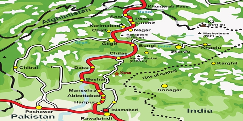
The Karakoram Highway (KKH): An Engineering Marvel  The Karakoram Highway (KKH), N-35, stands as one of the greatest wonders of the modern world. It is an awe-inspiring feat of human determination and ingenuity fondly referred to as the 8th wonder of the world. This 887-kilometer highway traverses along the Indus for 310 kilometers. Before meeting the Indus at the confluence of three mighty mountain ranges, it passes through Gilgit, Hunza, and Khunjerab. The highway runs through the Karakoram Range where 12 out of the 30 highest mountains in the world majestically overlook the KKH. Indeed, there is no other highway on earth that can rival the Karakoram Highway’s richness of attractions and breathtaking vistas. Origin and Journey of the Karakoram Highway Spanning an impressive 1300 kilometers (800 miles), the KKH commences its journey from the historic city of Hassan Abdal, approximately 45 kilometers from Islamabad on the Islamabad – Peshawar Highway. Its asphalt ribbon weaves through the cities of Abbottabad and Manshera crosses the majestic River Indus at Thakot, and continues on to Gilgit, meandering through the rugged mountains of Besham, Pattan, Sazin, and Chilas, before gracefully passing through Hunza and Sost. Finally, the highway reaches its zenith at the Khunjerab Pass, standing tall at an astonishing 4,733 meters (15,750 ft) above sea level. This pass, also known as Zero Point, marks the border between Pakistan and China. As the highway continues its journey, it enters the high Central Asian plateau and winds down through the Pamirs until it reaches Kashgar, situated at the western edge of the Taklamakan Desert. Gilgit-Baltistan is a treasure trove of history and natural wonders. It beckons travelers from all corners of the world to witness its splendor. As you explore this enchanting region, you will undoubtedly be captivated by the stories etched into its landscapes and monuments, a testament to the richness of its cultural heritage and the indomitable spirit of its people. Major Attractions along the Karakoram Highway The Karakoram Highway is undoubtedly crowned with a plethora of attractions, showcasing a harmonious blend of ancient rock carvings, awe-inspiring petroglyphs, mesmerizing natural beauty, and remarkable man-made marvels. Here are some of the major Karakoram Highway attractions that continue to captivate travelers from around the globe: The Khyber Pakhtunkhwa Section The Karakoram Highway passes through the plains, lush hills, and barren mountains of the Khyber Pakhtunkhwa before it enters the Himalayan range of Gilgit-Baltistan which boasts the height of the Karakoram Highway Attractions in the region. Mansehra Rock Edicts  Ashoka Rocks MansehraLocated on the north side of the town of Mansehra, the Ashoka Rocks bear witness to history with 14 edicts engraved by order of the Mauryan King Ashoka in the 3rd century BC. Although the Kharoshti script inscription is fading away, shelters have been built to protect this invaluable relic, making it accessible to visitors. The three granite boulders bearing 14 edicts engraved by order of the Mauryan King Ashoka in the 3rd century BC are located on the north side of the town of Mansehra. The inscription bearing Kharoshti script is fading away and almost impossible to see despite the shelters to protect it. Diamer Section: Threshold to Gilgit-Baltistan The Diamer Section runs in the rugged mountains for about 200km starting from the border between Tangir and Kohistan to Jaglot near the junction point of three great mountain ranges where Gilgit River and Indus converge. Shatial Petroglyphs A treasure trove of Buddhist archaeological wonders, the Shatial Rock Art Carvings or Petroglyphs can be found along the Karakoram Highway, previously known as the Old Silk Route. Carved into large rocks, these petroglyphs depict Jataka tales and Stupas, symbolizing the journeys of monks and pilgrims to Gandhara during the Buddhist era. Sadly, the construction of dams like the Diamer-Basha Dam and Dassu Dam has put these carvings in jeopardy, threatening their existence. Thalpan Petroglyphs The town of Chilas is surrounded by striking petroglyphs, particularly the ‘Chilas I’ site, which features inscriptions on both sides of the KKH and is considered a key Karakoram Highway Attraction spot. One of the most striking carvings here is the depiction of a large stupa with flying banners. Across the river, visitors can marvel at stones bearing art showcasing mythical animals, battle scenes, royal lineages, and Buddhist tales. Another site, ‘Chilas II,’ located near the police check post on the KKH, features a huge rock adorned with hunting and battle scenes, a Buddhist stupa, the long-horned ibex, and symbols of fertility. Nanga Parbat View The Thakot Bridge is the base point for an unforgettable journey to Fairy Meadows and the base camp of Nanga Parbat, famously known as the “Killer Mountain”. The bridge is situated approximately 78 kilometers south of Gilgit.  The Thalechi viewpoint offers travelers a perfect spot to pause and admire the sublime beauty of Nanga Parbat. Gems in Gilgit Region Gilgit is the administrative headquarters of Gilgit-Baltistan. The region is enormously blessed with historical monuments and breathtaking natural landscapes.  About 90km section of the Karakoram Highway from Jaglot to Guro (Jaglot) passes through the region. Partab Bridge The Partab Bridge is located about 40 kilometers southeast of Gilgit. It played a crucial role in connecting Gilgit with Bunji, Astore, and Kashmir long before the construction of the Karakoram Highway. Built between 1889 and 1893, this suspension bridge served as a vital communication link and facilitated trade. However, during the 1947 revolt when Gilgit gained independence from Dogra Raj, the bridge was burnt down. Despite facing decades of neglect, it was rebuilt after the 2010 floods, standing as a testament to human resilience. Junction Point of Three Great Mountain Ranges Jaglot, a mere 40 kilometers southeast of Gilgit, hosts the Junction Point of the Three Mountain Ranges. Here, the Karakoram, Himalaya, and the Hindukush converge. This unique location also marks the confluence of the Gilgit and Indus Rivers. About 5 km to the north, the Skardu road diverges from the KKH. Standing at the monument, visitors are treated to splendid views of the meeting of these three

Karakoram Highway Attractions Read Post »

, , , , , , , , , , , , , , , , , , , , , , , , , , , , , , , , , ,
Danyore Rock inscriptions
Gilgit-Baltistan

Danyore Rock Inscriptions

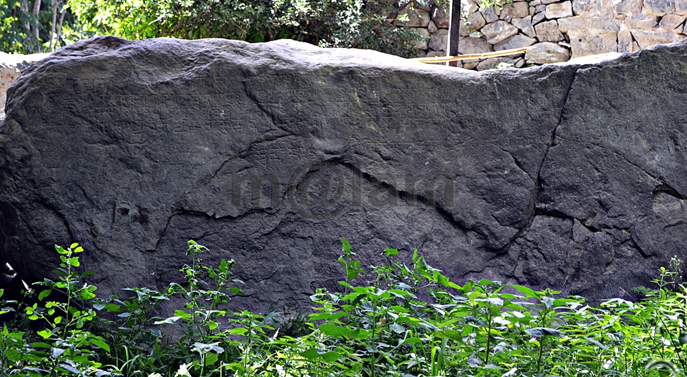
Danyore Rock Inscriptions: A Journey through Time The boulder bearing the Danyore Rock Inscriptions nestles amidst the breathtaking landscapes of Danyore. It is just a stone’s throw away from Gilgit city in Gilgit-Baltistan, Pakistan. These ancient engravings provide a captivating glimpse into the 7th and 8th centuries. However, despite its historical significance, this hidden gem remains shrouded in obscurity. It was known primarily to a select few involved in the fields of archaeology and tourism. Danyore: Where History Meets Natural Beauty Danyore is situated along the iconic Karakoram Highway leading to Hunza, south of Gilgit. It boasts a scenic setting nestled between the Gilgit River and the Hunza River. While the journey from Gilgit to Danyore is a mere 10-minute drive, locating the exact site of the Danyore Rock Inscriptions can prove to be a challenge. Additionally, the signage on the KKH guiding visitors has vanished. Moreover, the boulder itself is tucked away on a narrow street within the premises of a private residence. Surprisingly, the current occupants of the house are unaware of the historical significance concealed within their walls. The Enigmatic Inscriptions This colossal rock measures an impressive 13 x 7 feet. It proudly bears the names of Tibetan monarchs who once held sway over Gilgit during the 7th and 8th centuries. These names are meticulously inscribed in a five-line Sanskrit script, utilizing the late Brahmi script. Dr. Ahmed Hasan Dani, a renowned Pakistani archaeologist, posits that Prince Kumaramatya, a scion of the lineage mentioned in the Hatun inscription of the Ghizer Valley, likely commissioned these inscriptions. The inscriptions bestow royal titles upon Jayamangala Vikramaditya Nandi of the Vikramaditya family, crowning him as Patola Shahi Shahanushahi and Parama-Bhattaraka. Unraveling the Purpose Dr. Dani’s research suggests that the Danyore Rock Inscriptions may have served as a commemoration of a local ruler’s triumph. It may possibly signify the defeat of a Tibetan incursion in the upper Indus Valley. It is also documented that the Kingdom of Great and Little Bolor came under Tibetan suzerainty around A.D. 725.  Unfortunately, the ravages of time have taken a toll on the rock, causing the inscriptions to fade significantly. Nevertheless, it remains a poignant testament to the historical prominence of Sanskrit in the region and a priceless artifact that demands preservation. A Portal to Ancient Gilgit-Baltistan The Danyore Rock Inscriptions open a mesmerizing gateway into the ancient history and cultural heritage of Gilgit-Baltistan. As we stand in awe of these ancient carvings, it becomes evident that this land was once a vibrant center of civilization. It marks the influence of Tibetan rulers and the prevalence of Sanskrit as a dominant language. Basically, safeguarding these inscriptions and promoting awareness of their significance are vital steps in preserving the region’s historical legacy for generations to come. In the tranquility of Danyore, the Danyore Rock Inscriptions silently bear witness to a bygone era. Concealed within the heart of this town, these age-old engravings transport us through time, illuminating the rich history and cultural tapestry of Gilgit-Baltistan. Let us acknowledge the paramount importance of these inscriptions and unite in their conservation, ensuring that the legacy of our forebears endures for countless years ahead. FAQs (Frequently Asked Questions)What are the Danyore Rock Inscriptions? The Danyore Rock Inscriptions are ancient carvings on a large boulder located in Danyore, Gilgit-Baltistan, Pakistan. These inscriptions date back to the 7th and 8th centuries A.D. and bear the names of Tibetan kings who ruled Gilgit during that era. Where exactly are the Danyore Rock Inscriptions located? The Danyore Rock Inscriptions are situated on the premises of a private house in Danyore, across Gilgit City. The town of Danyore is easily accessible from Gilgit, and the rock can be found off the main Karakoram Highway, leading through a narrow street to the private house. What language are the inscriptions written in? The inscriptions on the rock are written in Sanskrit, using the late Brahmi script. Moreover, the five-line inscription reveals the names of Tibetan rulers and confers royal titles upon them. Why are the Danyore Rock Inscriptions significant? These inscriptions provide valuable insights into the ancient history of the region, particularly the rule of Tibetan kings in Gilgit during the 7th and 8th centuries. They offer evidence of Sanskrit’s presence in the area and commemorate the achievements or conquests of the rulers. What efforts are being made to preserve the Danyore Rock Inscriptions? Due to the limited knowledge of the inscriptions’ significance, preservation efforts have been minimal. However, raising awareness about their historical importance is a need of the time. It is possible through collaboration with local authorities and heritage organizations to ensure the conservation of this valuable archaeological site. Remember, the Danyore Rock Inscriptions are a fragile piece of history, and it is our responsibility to protect and cherish them for future generations to appreciate.

Danyore Rock Inscriptions Read Post »

, , , , , ,
Victory monument of Taj Mughal
Gilgit-Baltistan, Monuments

Victory Monument of Taj Mughal

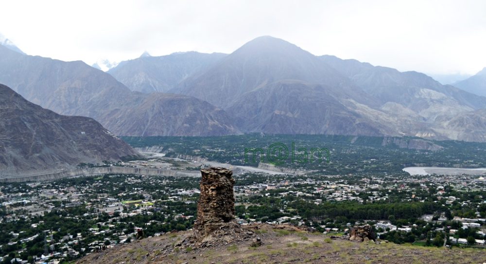
Exploring the Majestic Victory Monument of Taj Mughal Unveiling the Remarkable Tale of the 700-Year-Old Commemorative Tower in Gilgit, Pakistan Nestled gracefully upon the southern mountains of Gilgit town, Gilgit-Baltistan, Pakistan, stands the splendid Victory Monument of the Taj Mughal. Undoubtedly, the monument is a testament to history, triumph, and timeless beauty. With a history spanning over 700 years, this commemorative tower bears witness to the legacy of Taj-ud-Din Mughal. Taj-ud-Din was an Ismaili ruler from Badakhshan who graced Gilgit-Baltistan with his presence during the 13th century AD. Erected by his devoted soldiers, this monument stands tall at 21 feet and 10 inches, with a circumference of 14 feet and 4 inches, perpetuating the memory of his glorious victory. Journey to the Past: Unveiling the Monument’s Origin The Victory Monument of the Taj Mughal finds its sacred abode against the stunning backdrop of the southern mountains of Gilgit city. The Monument majestically sits about 1000 feet above Gilgit town. This awe-inspiring edifice not only oversees the enchanting villages of Gilgit and Danyore but also narrates a saga of victory and courage that continues to captivate the hearts of those who tread its path. Unveiling the Pathways: A Scenic Staircase Adventure Gone are the days of arduous treks and intricate routes. In order to promote history and tourism, access to the monument has been made easy. From the city center or the bus station, one can drive towards Serena Hotel in Jutial and follow the signboards leading to the hiking point. The monument is now reachable via a splendid flight of stairs, gracefully winding its way through rocky trails. These trails, adorned with the raw beauty of nature, create an immersive experience that heightens the anticipation of the forthcoming spectacle. As each step is taken, a sense of excitement and wonder builds, propelling us toward our destination. Cycle Track Marvel: A Gateway from Barmas to Jutial Adding to the allure of this journey is the newly constructed water channel Cycle Track, connecting Barmas to Jutial, Gilgit. One can do the monument from Barmas, the southern end of Gilgit, as well while enjoying the majestic views of Gilgit and surrounding valleys along the cycling trail. This ingeniously designed pathway presents an alternative route, one that promises a unique blend of adventure and tranquility. Unveiling the Monument’s Grandeur Architectural Resplendence: A Glimpse into the Monument’s Construction Erected upon the ridge of the Rocky Mountains, the Victory Monument stands as an embodiment of architectural finesse. Crafted meticulously with local stone and clay, this circular tower resonates with the echoes of a bygone era. Yet, the passage of time has not been without its effects, as the monument’s structural integrity slowly wanes, hinting at the ephemeral nature of existence. Temporary support has been tendered to its base, while the southern façade bears the marks of weathering, urging for a much-needed restoration. A Panoramic Tale: The Enchanting Vistas from the Monument’s Peak Gazing from the heights of the Victory Monument, one is rewarded with an awe-inspiring panorama that unfurls before the eyes. Gilgit town, stretching from Bagrot in the east to Baseen in the west, is caressed by the winding embrace of the Gilgit River. The tower, known as “Shikaari” in the local Shina language, offers an unobstructed view of the surrounding valleys, cradled by vigilant mountain sentinels. Embracing the Experience: Best Time & Route to Embark Packing Essentials: The Checklist for a Memorable Voyage The monument can be accessed at any time of the year. During peak summers, only early morning or late afternoon time is suggested to avoid heat. Preparation is the key to a fulfilling visit to the Victory Monument. As you tread upon the barren mountain terrain, remember to arm yourself with a water bottle, ensuring hydration amidst the arid landscape. Similarly, the scorching sun necessitates the application of sunburn cream, while sturdy shoes guarantee secure footing. Complete your ensemble with sunglasses, and a hat/cap, and equip yourself with a camera or cell phone to capture the moments that unfold. Embarking Beyond: Exploring Gilgit’s Treasures Beyond the resplendent Victory Monument, Gilgit extends an invitation to delve into its treasury of attractions. Venture into the embrace of ancient history as you encounter the 7th-century Karga Buddha, a silent sentinel of bygone times. In addition, Biddulph House, Hal Ga Naal, Hanzal Stupa, Gilgit Suspension Bridge, Chinar Bagh, Buddhist Rock Carvings, and the hiking track near KIU await your exploration. Each movement narrates a unique chapter in the tale of Gilgit’s legacy. Charting Your Course: Navigating to Gilgit Accessing Gilgit is a journey that intertwines with the thrill of the destination. Flights operate daily from Islamabad, weather permitting, offering a gateway to this realm of wonder. Likewise, roadways pave the way from Islamabad along the (Karakoram Highway) KKH and from Chitral via the Gilgit-Chitral road. While those journeying from Kashgar in China tread the path along the KKH—the months from May to mid-October emerge as the optimal time to embark on this odyssey. Capturing Memories: The Must-Have Essentials A pilgrimage to Gilgit demands thoughtful preparation. Ensure a water bottle accompanies you, quenching your thirst amid the landscapes. The embrace of the sun necessitates the shield of sunburn cream, while sturdy footwear guarantees steadfast steps. Moreover, bedecked with sunglasses and a hat, seize the moment with a camera or cell phone, encapsulating memories that endure. The Victory Monument of Taj Mughal stands as a living testament to a bygone era. It proudly stands as a beacon of triumph that graces the mountains of Gilgit. As you traverse the path to this historical marvel, let the vistas of Gilgit and the tales.

Victory Monument of Taj Mughal Read Post »

, , , , , , , , , , , ,
Passu Cathedral
Gilgit-Baltistan, Mountains

Passu Cones

Passu Cones: A Natural Wonder in Pakistan’s Karakoram Range Hidden in the grandeur of Pakistan’s Karakoram Mountain Range, the Passu Cones offer an unforgettable sight. These jagged, cathedral-like peaks, situated north of the serene Passu Valley and across the Hunza River, rise dramatically into the sky. Renowned for their distinctive shape, these spires have become one of the most iconic and photographed landscapes in the Gilgit-Baltistan region, showcasing the untamed beauty of Pakistan’s northern terrain. The Mystique of Passu The origins of the name “Passu” remain a mystery, but the region itself is a treasure trove of natural and cultural attractions. Visitors can explore the charming Passu Village, marvel at the icy grandeur of the Passu Glacier, admire the soaring Passu Peak, or gaze at the famed Passu Cathedral. All of these wonders are easily visible from the legendary Karakoram Highway (KKH), making the journey as memorable as the destination. Where Are the Passu Cones? The Passu Cones are located near Passu Village, approximately halfway between Gilgit and the Khunjerab Pass, the border crossing between Pakistan and China. Situated about 50 km from Karimabad and 150 km from Gilgit, they are part of the Batura Muztagh Range within the Karakoram system, one of the world’s most challenging and awe-inspiring mountain ranges. Locally known as Tupopdan, these peaks are also referred to as the Passu Cathedral or Cathedral Spires. They first captured international attention when British mountaineers scaled them in 1987, further enhancing their mystique and allure. What Makes Passu Cones Unique? The Passu Cones are celebrated for their dramatic, pyramid-like structure, which creates a stunning silhouette against the sky. Standing at an elevation of 6,106 meters (20,033 feet), they form a striking backdrop to the lush valleys and the tranquil Hunza River below. Unlike many remote peaks in the region, the Passu Cones are easily accessible from the Karakoram Highway, making them an ideal destination for travelers of all levels. Their ability to reflect light at sunrise and sunset creates a mesmerizing display of colors, from golden hues to deep shadows, captivating visitors and photographers alike. Captivating Beauty of Passu Cones The Passu Cathedral is perhaps the most recognizable feature of the Passu Valley. Soaring nearly four kilometers from its base, this pyramid-like peak is a testament to the raw power of nature. As the day begins, the first rays of sunlight illuminate the cones’ jagged edges, casting a play of light and shadow across their surface. During winter, the peaks become cloaked in snow, adding a pristine white brilliance to their already majestic presence. At sunset, the peaks glow with golden and bronze hues, offering an unforgettable visual treat for spectators. Getting to Passu Cones By Road: From Gilgit, take the Karakoram Highway toward Hunza. Public buses and private vehicles are readily available. By Road: From China, take the Karakoram Highway toward Hunza via Khunjerab Pass. Public buses and private vehicles are readily available from Tashkurghan. By Air: Fly to Gilgit from Islamabad and continue by road to the Hunza Valley. Tips for Visitors Stay hydrated and be mindful of altitude changes. Wear sturdy shoes, especially if you plan to trek. Respect the customs and traditions of the local community. Bring a camera—every moment at the Passu Cones is worth capturing. Why Visit Passu Cones? The Passu Cones epitomize the wild beauty of northern Pakistan, offering an experience that is both awe-inspiring and deeply moving. Whether you’re chasing adventure, capturing stunning photographs, or simply soaking in the serenity of nature, the Passu Cones promise memories that will last a lifetime. Best Time to Visit The ideal time to visit the Passu Cones is between April and October, when the weather is pleasant, and the natural surroundings are at their most vibrant. Spring and autumn are particularly stunning, with blooming flowers and colorful foliage. Winter brings a magical, snow-covered charm but can make road access more challenging. Nearest Attractions Passu Glacier Hussaini Suspension Bridge Borith Lake Batura Glacier Borith Lake Afsang View Point Ondra Poygah Attabad Lake Haldikish Yak Grill Rainbow Bridge Khunjerab Pass

Passu Cones Read Post »

, , , , , , , , , , , , , , , ,
Baltit Fort Hunza
Forts, Gilgit-Baltistan

Baltit Fort

Baltit Fort: Tibetan-Influenced Architectural Marvel Perched with a commanding view upon the moraine of Ultar Glacier, Baltit Fort stands as a testament to history. It offers a jaw-dropping vista of Hunza Valley and its intricate network of tributaries. This architectural gem, boasting over 700 years of history, was originally constructed as both a defensive stronghold and a symbol of authority by the rulers of Hunza. Today, it has transformed into a cultural center and museum. The fort is recognized globally and has secured numerous international awards. A Tale of Two States In a historical landscape where mountain kingdoms reigned supreme, Gilgit-Baltistan and Chitral were comprised of several small independent states. The Mirs, known as Thumo in Hunza and Nager, ruled their respective state. Notably, Hunza and Nagar, two major principalities separated only by the Hunza River, engaged in frequent clashes, fortifying their power with imposing strongholds. The chronicles of history reveal that the early Hunza rulers inhabited the Altit Fort, but a fierce conflict between the two sons of Mir Sultan, Shah Abbas (Shabos) and Ali Khan (Aliqan), led to their separation. Shabos, the elder son, relocated to Baltit Fort, ultimately solidifying its position as the epicenter of Hunza’s power. In the early 15th century, Ayasho II, Mir of Hunza at the time, forged a matrimonial alliance by marrying Princess Shah Khatoon from Baltistan, a region often likened to little Tibet. The princess brought with her a retinue of skilled craftsmen who orchestrated significant architectural modifications in both Altit Fort and Baltit Fort, creating a harmonious fusion of Tibetan and local architectural influences that still resonate in these structures today. The fortified village of Baltit, once known as “Agaai Koot” or the Heavenly Fort, and the nearby Altit, initially referred to as Hunokushal (derived from “Huns”), witnessed a linguistic evolution as Balti craftsmen introduced terms like “Elte” and “Delte” to denote “Here” and “There.” These linguistic nuances gave birth to the names Altit and Baltit, etching their place in history. Turbulence and Transformation The 19th century brought turmoil as the Maharaja of Kashmir launched attacks, followed by the British invasion in 1891. These incursions inflicted partial damage to the fort’s architecture and ushered in political upheaval in Hunza. In a daring move, Mir Safdar Ali Khan and Wazir Dadu, along with their families and supporters, sought political asylum in Kashghar. The British, in their pursuit of strategic control, reshaped the forts according to their defense needs. They dismantled the fortified walls and watchtowers of the old Baltit village and Baltit Fort. Additionally, they imposed their governance by appointing Mir Mohammad Nazim Khan as the ruler of the Hunza state. Subsequent alterations by Mir Mohammad Nazim Khan included demolishing several third-floor rooms and adding new ones, lending the fort a British colonial aesthetic with lime wash and colorful glass panel windows. These changes remained largely unchanged until the fort’s eventual restoration. Architectural Marvel Baltit Fort is a remarkable wooden pegged stone structure adorned with mud plaster. Its interior boasts exquisite woodcarvings that have since become a hallmark of architectural finesse. The three-story edifice perches gracefully on a moraine, affording breathtaking vistas of the valley below. The basement of the fort houses granaries and storage rooms, supported by narrow man-made terraces that safeguard its ancient foundations. Ascending to the first floor reveals the main kitchen, a winter guestroom, a spacious winter house, a private meeting room, guardrooms, and additional storage spaces, all interconnected for seamless functionality. The second floor graces visitors with living quarters, a balcony adorned with bay windows, and a magnificent open terrace, crowned by a Moghul-style wooden canopy sheltering a regal throne. This vantage point offers awe-inspiring views of the Hunza and Nagar valleys.  Moreover, the scenery of iconic  Rakaposhi, Diran Peak, Golden Peak, Ultar, and the Lady Finger is simply breathtaking. The fort’s third floor hosts a modest mosque and a guard shelter tucked away in the corner, completing the architectural splendor. Restoration and Renewal The fort was vacated by the local Mir family in 1945 and it remained abandoned for years, succumbing to decay. Concerned authorities contemplated its rehabilitation. Mir Gazanfar Ali Khan II, a descendant of the ruling Mirs of Hunza, made a momentous decision by gifting the fort to the Aga Khan Trust for Culture. This charitable organization embarked on a restoration project in 1989. Getty Grant Program (USA), the Norwegian Agency for Development Cooperation, and the French Authorities donated to the restoration project. The restoration efforts culminated in 1996, meticulously reviving the fort’s former glory. The restoration work was executed with such precision that it recaptured the fort’s bygone grandeur. The Mirs lost their power in 1974 as a result of the accession of princely states to the mainland. The Baltit Fort is serving as a museum now—a beacon of preserved culture for generations to come. Access and Appreciation Baltit Fort, nestled in Karimabad (Baltit), was once the capital of District Hunza. The fort is accessible via the Karakoram Highway (KKH), approximately 100 kilometers north of Gilgit, the capital of Northern Areas, Pakistan. The fort commands a panoramic view of the entire Hunza-Nagar region, making it easily discernible from the Karakoram Highway. Visiting Hours: Summer: 09:00 to 17:30 hrs (April 1st to Oct 30th) Winter: 09:30 to 16:00 hrs (November 1st to March 31st) Dining Amidst History In homage to the legacy of former Hunza state rulers, who hosted elaborate dinners and musical soirees at Baltit Fort, it is now possible to arrange a dinner with light music for groups of a minimum of eight guests. This unique dining experience features traditional dishes crafted from local organic produce, including dried apricots and the oil extracted from apricots, walnuts, and almonds. A Legacy of Awards Baltit Fort’s cultural significance and meticulous restoration have not gone unnoticed, earning it a cascade of prestigious awards: Grand Award to Aga Khan Cultural Services (AKCSP) in 1997 for “Restoration and Re-use of the Baltit Fort” by PATA (Pacific Asia Travel Association). British Airways Tourism for Tomorrow Global Award

Baltit Fort Read Post »

, , , , , , , , ,
Scroll to Top