Gilgit

Gappa Valley
City Breaks, Gilgit-Baltistan, Tourists Destinations in Pakistan

Gappa Valley

Exploring the Enchanting Charms of Gappa Valley The Gappa Valley is a breathtaking meadow and an emerging tourist attraction alluring visitors from within and outside Pakistan. If you’re in search of an enchanting escape, then the Gappa is your choice. Nestled in the heart of the Nagar Valley in Gilgit-Baltistan, this hidden gem is quickly rising to prominence as a must-visit tourist destination. With its gushing glacial waters, terraced fields, expansive meadows, lush green hills, and majestic snow-covered mountain peaks in the background, this enchanting valley promises an unparalleled experience. Embracing Nature’s Beauty in Gappa Valley Gappa is a haven for nature enthusiasts, boasting pristine pine jungles, bubbling fountains, vast grasslands, and breathtaking vistas of Rakaposhi. The journey through the majestic Chalt Bala (Upper) and its pastures is an experience to memorize for a lifetime. It comes as no surprise that this valley has become a magnet for tourists seeking solace in the embrace of nature. Unveiling the Treasures of Nagar Valley Nagar Valley, home to the Gappa Valley, is a treasure trove of towering mountain peaks, crystal-clear lakes, and ancient glaciers. This region, located north of Gilgit city along the Karakoram Highway, remains a relatively undiscovered gem. The Chalt Valley marks the beginning of Nagar Valley, and Gappa is the first adventure that beckons. Gappa Valley: A Playground for All Seasons Gappa Valley’s allure knows no bounds, attracting visitors year-round. During the summer months, both local and international tourists flock to this haven to relish its serene ambiance and camping opportunities. The ideal time to visit is between June and September for the ultimate summer experience, while winter enthusiasts should plan a trip between December and February. Keep in mind that the road leading to the valley remains unpaved beyond the Chalt intersection on the Karakoram Highway, so opting for a sturdy Jeep is advisable. Discovering Hidden Treasures in Gappa Valley Gappa isn’t just a sanctuary for nature lovers; it’s a paradise for trekkers and those seeking peace alike. The region’s natural forests, pristine fountains, lush grasslands, and delectable local cuisine provide a holistic experience. Moreover, the warm and hospitable locals ensure that your visit is truly unforgettable. However, the crowning jewel of the valley is the mesmerizing view of Rakaposhi Peak, a sight that will leave an indelible mark on your memory. Outdoor Adventures Whether you’re an individual traveler or part of a family, there are plenty of spots to prepare and enjoy your own meals. Picture yourself cooking amidst the shade of towering pine trees with glacier water flowing nearby. The local shepherds extend their hospitality by offering delicious buttermilk (Lassi) and traditional flour Crepes (Giyaling). However, do remember to carry all your cooking supplies from the market. Adventure Awaits in Gappa Valley For adventure seekers, Gappa Valley offers a plethora of hiking and trekking activities. Exploring the vast expanse of the valley by hiking through its surrounding pastures and hills is an exhilarating experience. The trekking trail from Gappa Valley to Naltar Valley is a compelling reason in itself to plan a visit. Finding Your Way to Gappa Valley Gappa is accessible by 4WD. The journey to Gappa commences with a scenic drive through Chalt Bala, branching off from the main Karakoram Highway. While it was previously accessible from the District Nagar Check Post at KKH towards Chalt village, make sure to check current access points and trail conditions for an effective journey. To be precise, the road branches out from the Police check-post near the Collision Point of Continental Plates. Drive to the Chalt Valley and proceed to Gappa. While the drive is an adventure in itself, lasting approximately one and a half hours, it’s unquestionably worth the effort. As you approach Gappa Valley, the landscape transforms, welcoming you with open arms. The Gappa Valley is a paradise waiting to be discovered. Whether you’re an avid trekker, a nature enthusiast, or simply someone seeking serenity, Gappa offers an array of experiences that will undoubtedly leave you in awe. Plan your journey and unlock the enchanting charms of Gappa today.
Gappa Valley Read Post »

, , , , , , , , , ,
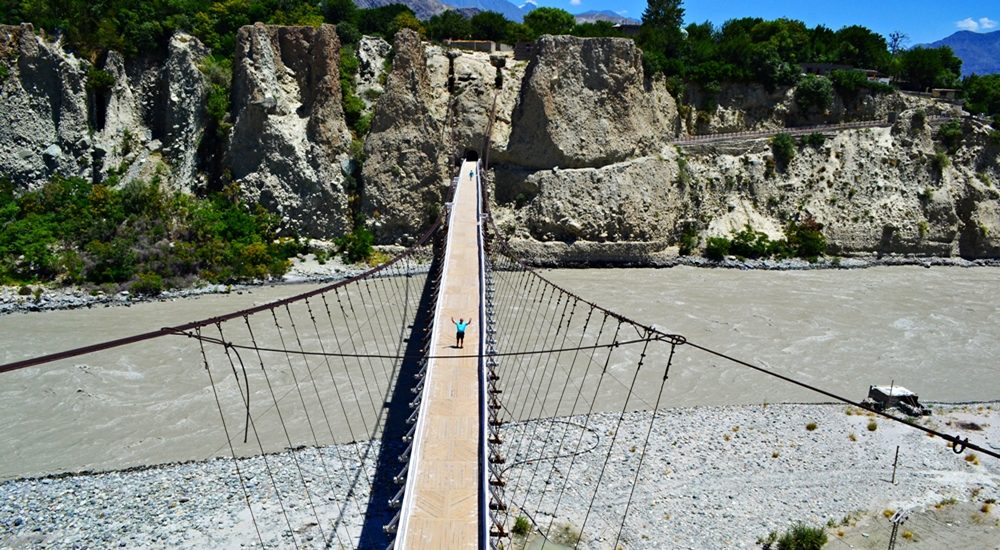
Danyore Suspension Bridge view from KIU premises
Gilgit-Baltistan, Monuments

Danyore Suspension Bridge

Danyore Suspension Bridge: A Gateway to Gilgit’s History In the heart of Gilgit-Baltistan, Pakistan, lies a hidden gem called the Danyore Suspension Bridge. The bridge not only stands as a testament to engineering prowess but also weaves a tale of resilience and connectivity. The Danyore Suspension Bridge, a venerable structure, boasts a rich history that has etched its name in the annals of Gilgit’s development. Bridging the Gap Gilgit’s Historical Connection Before the Karakoram Highway breathed life into this region in 1978, Gilgit-Baltistan remained an isolated territory, isolated from the rest of the country. Poor infrastructure compounded the hardships of its residents. Gilgit, the bustling administrative hub, magnetized people from far and wide for various reasons. People had to travel to Gilgit for education, employment, trade, healthcare, or other pursuits. However, those residing to the south of Gilgit Town, separated by the Hunza River, faced daunting challenges in reaching the town. Prior to the introduction of the local raft (Jaalo) in 1945, the journey to Gilgit involved a lengthy detour. It would consume nearly an entire day—a stark contrast to the mere 15 to 20 minutes it takes today. Pioneering Vision The pressing need for a bridge became apparent. The residents of Danyore and the southern regions rallied together to generate a substantial fund of Rs. 20,000 in the late 1950s. The initial attempt to construct a suspension bridge ended in tragedy. The Hunza River, in its capricious nature, washed it away due to its close proximity to the riverbed. Undaunted, the community selected a higher location for a new bridge. Each household contributed both funds and construction wood, culminating in the successful completion of the present-day suspension bridge in 1960. A Lifeline for Generations For over half a century, the Danyore Suspension Bridge has been a reliable conduit for travelers to Gilgit, mitigating the hardships faced by frequent commuters. Unlike the local raft, which operated only during daylight hours, the bridge provided round-the-clock, hassle-free passage, significantly enhancing the quality of life for residents. The Art of Construction Masterful Craftsmanship The bridge’s construction was overseen by Ahmed Ali, popularly known as “Thikedar Bereno,” a celebrated builder and self-taught engineer from Hunza, renowned for his exceptional construction skills, particularly in bridge projects throughout Gilgit-Baltistan. Work on the Danyore Suspension Bridge commenced in 1957 and concluded in 1960. The primary tasks included erecting the bridge over the Hunza River and excavating a single-lane curved tunnel to the south, connecting to Danyore—a remarkable feat accomplished by local laborers without sophisticated engineering equipment. A Spectacle to Behold Situated nearly 2 km upstream from the confluence of the Hunza River and the Gilgit River, the bridge was initially designed for mini-vehicle use until the construction of an alternative concrete bridge. The western end of the suspension bridge leads to the KIU campus, providing access to Gilgit town, while the eastern end connects to a single-lane tunnel on the Danyore side, joining the Karakoram Highway. The bridge’s location, length, and design render it one of the world’s most spectacular bridges. Crossing the bridge and navigating the tunnel requires technical finesse, putting local drivers’ skills and nerves to the test. A Transition into the Present Regrettably, the Danyore Suspension Bridge has been closed to conventional transportation due to safety concerns, now exclusively accessible to pedestrians and motorcyclists. A nearby concrete bridge has been constructed to accommodate all types of traffic. Attraction Reimagined In 2018, the Danyore Suspension Bridge underwent a transformative renovation. The approach roads on both ends of the bridge have been revitalized and adorned, transforming it into a tourist hotspot. On the Gilgit side, a significant Buddhist rock carving site awaits exploration, adding to the bridge’s allure. The nearby Chinese Graveyard, situated on the KKH, beckons as a must-visit tourist attraction. Both elevated vantage points offer spectacular views of the bridge, which stands gracefully in its lower setting. Walking across the bridge or simply gazing at its majesty promises an unforgettable experience for every visitor. The Danyore Suspension Bridge stands not only as a structural marvel but also as a testament to human determination. Its rich history, remarkable construction, and current appeal as a tourist destination make it a cherished part of Gilgit’s heritage. As travelers and tourists flock to this iconic site, they become a part of the ongoing legacy that this bridge represents.

Danyore Suspension Bridge Read Post »

, , , , , ,
Khunjarab Pass
Gilgit-Baltistan, Passes

Khunjerab Pass

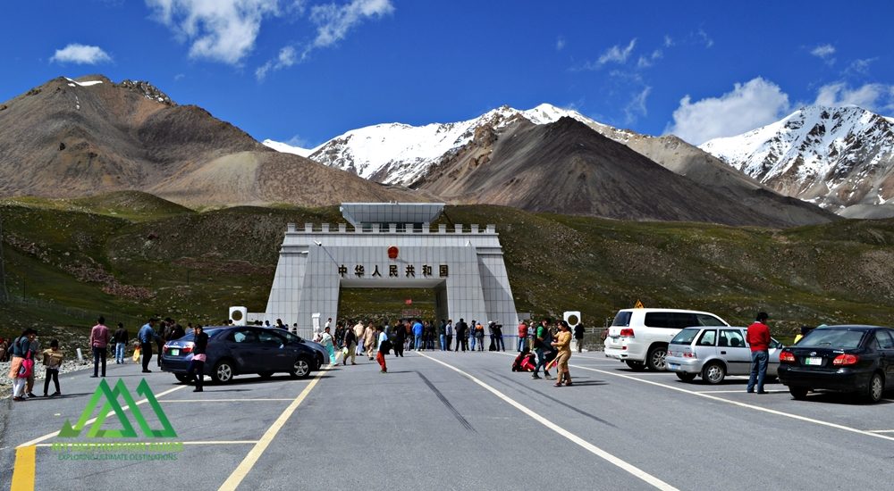
Discover the Khunjerab Pass: A High-Elevation Gateway The Khunjerab Pass, nestled at a breathtaking altitude of 4,700 meters, stands as the world’s highest paved international border crossing. It serves as a crucial junction linking the Gilgit-Baltistan region in northern Pakistan to China’s western Xinjiang province. This article delves into the beauty and significance of this remarkable pass, highlighting its construction, attractions, and access. Khunjerab Pass: A Natural Wonder Situated amidst the majestic Karakoram Mountains, the Khunjerab Pass, often referred to as Khunzerav, boasts expansive snow-capped peaks. During the summer months, this area transforms into a haven adorned with a kaleidoscope of wildflowers, creating a striking contrast against the glistening snow-clad mountains. The Khunjerab Pass offers some of the world’s most awe-inspiring scenery. The Birth of Hunza River This pass is the birthplace of the Hunza River. The snowmelt from the surrounding peaks converges to form a pristine creek that flows downward. Several of these tributaries ultimately merge to create the Hunza River, which eventually meets the Gilgit River in Gilgit. The Gilgit River continues its journey along the Karakoram Highway, eventually merging with the River Indus at the convergence of three mountain ranges before flowing onward to Thakot. Construction of the Khunjerab Pass Before the construction of the Karakoram Highway (KKH), the primary passes on the Karakoram Range were Kilik and Mintaka Passes to the north of Khunjerab. The decision to choose the Khunjerab Pass for the KKH was rooted in technical considerations. Kilik and Mintaka were deemed more vulnerable to air strikes. Consequently, Khunjerab was recommended in 1966 and realized in 1978. Attractions at Khunjerab Pass The Khunjerab Pass stands as a major tourist attraction, drawing both domestic and international visitors daily. The entire Karakoram Highway is a treasure trove of natural wonders and man-made marvels. At every turn, travelers are treated to breathtaking panoramas and opportunities for short hikes and photography. A journey along the highway to the border area promises a lifetime of unforgettable experiences. Khunjerab National Park A substantial portion of the Khunjerab Pass is enveloped by the Khunjerab National Park, established in 1979 to safeguard endangered species. Within the park’s boundaries dwell rare animals like the Marco Polo sheep and the elusive Snow Leopard. From the border area, visitors can gaze across the border into China’s Xinjiang province. Access to Khunjerab Pass Access to the Khunjerab Pass varies by location: Pakistani Side Sost Customs and Immigration Check Post: 75 km Hunza: 180 km Gilgit Airport: 280 km Islamabad (Capital City): 890 km Chinese Side Tashkurgan: 130 km Kashgar: Approximately 420 km Urumqui: 1,890 km Informative road signs provide tourists with distance-related information. It’s worth noting that traffic follows a right-hand drive on the Chinese side and a left-hand drive on the Pakistani side, making the border the transition point. Travel Tips While the Pakistani side of the highway is well-paved, the steep altitude gain near the pass can slow down your journey. Additionally, checkpoints on both sides can lead to further delays. On the Pakistani side, an entry fee is applicable to both local and international tourists. At present, the fee stands at Rs. 40 for Pakistani tourists and $8 for international tourists. It’s advisable to check for annual revisions of these fees to manage expenses, especially for larger groups. The Khunjerab Pass is open for trade and tourism from May to November. During the remaining months, it remains closed due to heavy snowfall. In November, the extreme cold and strong winds can make the visit challenging. However, under favorable weather conditions, it remains a must-visit destination. Bus Service A daily bus service operates between Sost, the last human settlement along the KKH in Pakistan, and Tashkurgan in China. Both Pakistani and Chinese buses provide transportation from their respective stations in their home countries. Travelers can also hire private cars or 4WD vehicles from Sost to Tashkurgan for drop-off and continue their journey to Kashgar using shared rides or taxis. Precautions for a Safe Journey Due to the high altitude, some tourists may experience altitude sickness, characterized by dizziness, headaches, or shortness of breath. It’s advisable to descend to lower altitudes immediately or carry altitude sickness medication in advance. During peak summer, there’s a risk of flooding due to rapid snowmelt near the pass, so a timely return is recommended. Additionally, loose gravel, especially during rainfall, can pose hazards on the highway. Whether you’re on a motorcycle or driving a car, exercise caution and avoid overconfidence. Despite renovations, the Karakoram Highway has claimed lives, particularly among tourists from lower-altitude cities. It’s essential to familiarize yourself with the entire highway before embarking on a self-drive tour. Embrace the journey and return home with cherished memories. Before You Go Pakistani tourists must carry their CNIC, while foreign tourists require a passport for identification. Foreign tourists and Pakistani nationals traveling to China must obtain a Chinese Visa (a pass for residents of Gilgit-Baltistan traveling to the nearby city of Kashgar). Buses from Sost to Tashkurgan depart in the morning between 8:00 AM and 9:00 AM, so purchasing tickets in advance is advisable. If you prefer to hire a car, private Pakistani vehicles are allowed to travel all the way to Kashgar. The fare is negotiable and not fixed.

Khunjerab Pass Read Post »

, , , , , , , , , , , , , , , , , ,
Victory monument of Taj Mughal
Gilgit-Baltistan, Monuments

Victory Monument of Taj Mughal

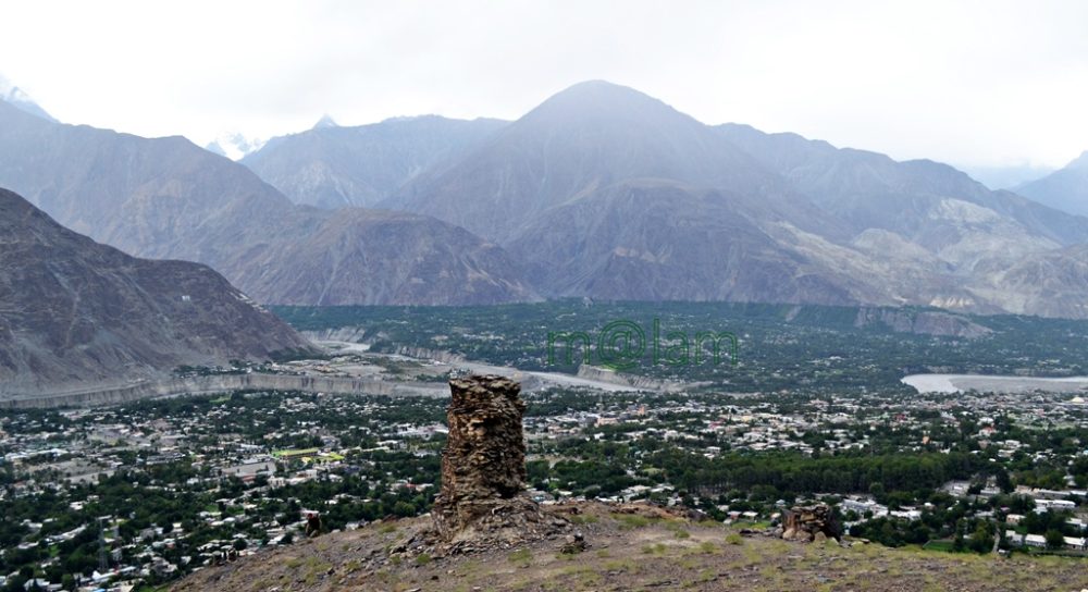
Exploring the Majestic Victory Monument of Taj Mughal Unveiling the Remarkable Tale of the 700-Year-Old Commemorative Tower in Gilgit, Pakistan Nestled gracefully upon the southern mountains of Gilgit town, Gilgit-Baltistan, Pakistan, stands the splendid Victory Monument of the Taj Mughal. Undoubtedly, the monument is a testament to history, triumph, and timeless beauty. With a history spanning over 700 years, this commemorative tower bears witness to the legacy of Taj-ud-Din Mughal. Taj-ud-Din was an Ismaili ruler from Badakhshan who graced Gilgit-Baltistan with his presence during the 13th century AD. Erected by his devoted soldiers, this monument stands tall at 21 feet and 10 inches, with a circumference of 14 feet and 4 inches, perpetuating the memory of his glorious victory. Journey to the Past: Unveiling the Monument’s Origin The Victory Monument of the Taj Mughal finds its sacred abode against the stunning backdrop of the southern mountains of Gilgit city. The Monument majestically sits about 1000 feet above Gilgit town. This awe-inspiring edifice not only oversees the enchanting villages of Gilgit and Danyore but also narrates a saga of victory and courage that continues to captivate the hearts of those who tread its path. Unveiling the Pathways: A Scenic Staircase Adventure Gone are the days of arduous treks and intricate routes. In order to promote history and tourism, access to the monument has been made easy. From the city center or the bus station, one can drive towards Serena Hotel in Jutial and follow the signboards leading to the hiking point. The monument is now reachable via a splendid flight of stairs, gracefully winding its way through rocky trails. These trails, adorned with the raw beauty of nature, create an immersive experience that heightens the anticipation of the forthcoming spectacle. As each step is taken, a sense of excitement and wonder builds, propelling us toward our destination. Cycle Track Marvel: A Gateway from Barmas to Jutial Adding to the allure of this journey is the newly constructed water channel Cycle Track, connecting Barmas to Jutial, Gilgit. One can do the monument from Barmas, the southern end of Gilgit, as well while enjoying the majestic views of Gilgit and surrounding valleys along the cycling trail. This ingeniously designed pathway presents an alternative route, one that promises a unique blend of adventure and tranquility. Unveiling the Monument’s Grandeur Architectural Resplendence: A Glimpse into the Monument’s Construction Erected upon the ridge of the Rocky Mountains, the Victory Monument stands as an embodiment of architectural finesse. Crafted meticulously with local stone and clay, this circular tower resonates with the echoes of a bygone era. Yet, the passage of time has not been without its effects, as the monument’s structural integrity slowly wanes, hinting at the ephemeral nature of existence. Temporary support has been tendered to its base, while the southern façade bears the marks of weathering, urging for a much-needed restoration. A Panoramic Tale: The Enchanting Vistas from the Monument’s Peak Gazing from the heights of the Victory Monument, one is rewarded with an awe-inspiring panorama that unfurls before the eyes. Gilgit town, stretching from Bagrot in the east to Baseen in the west, is caressed by the winding embrace of the Gilgit River. The tower, known as “Shikaari” in the local Shina language, offers an unobstructed view of the surrounding valleys, cradled by vigilant mountain sentinels. Embracing the Experience: Best Time & Route to Embark Packing Essentials: The Checklist for a Memorable Voyage The monument can be accessed at any time of the year. During peak summers, only early morning or late afternoon time is suggested to avoid heat. Preparation is the key to a fulfilling visit to the Victory Monument. As you tread upon the barren mountain terrain, remember to arm yourself with a water bottle, ensuring hydration amidst the arid landscape. Similarly, the scorching sun necessitates the application of sunburn cream, while sturdy shoes guarantee secure footing. Complete your ensemble with sunglasses, and a hat/cap, and equip yourself with a camera or cell phone to capture the moments that unfold. Embarking Beyond: Exploring Gilgit’s Treasures Beyond the resplendent Victory Monument, Gilgit extends an invitation to delve into its treasury of attractions. Venture into the embrace of ancient history as you encounter the 7th-century Karga Buddha, a silent sentinel of bygone times. In addition, Biddulph House, Hal Ga Naal, Hanzal Stupa, Gilgit Suspension Bridge, Chinar Bagh, Buddhist Rock Carvings, and the hiking track near KIU await your exploration. Each movement narrates a unique chapter in the tale of Gilgit’s legacy. Charting Your Course: Navigating to Gilgit Accessing Gilgit is a journey that intertwines with the thrill of the destination. Flights operate daily from Islamabad, weather permitting, offering a gateway to this realm of wonder. Likewise, roadways pave the way from Islamabad along the (Karakoram Highway) KKH and from Chitral via the Gilgit-Chitral road. While those journeying from Kashgar in China tread the path along the KKH—the months from May to mid-October emerge as the optimal time to embark on this odyssey. Capturing Memories: The Must-Have Essentials A pilgrimage to Gilgit demands thoughtful preparation. Ensure a water bottle accompanies you, quenching your thirst amid the landscapes. The embrace of the sun necessitates the shield of sunburn cream, while sturdy footwear guarantees steadfast steps. Moreover, bedecked with sunglasses and a hat, seize the moment with a camera or cell phone, encapsulating memories that endure. The Victory Monument of Taj Mughal stands as a living testament to a bygone era. It proudly stands as a beacon of triumph that graces the mountains of Gilgit. As you traverse the path to this historical marvel, let the vistas of Gilgit and the tales.

Victory Monument of Taj Mughal Read Post »

, , , , , , , , , , , ,
Key Facts about Pakistan
Blogs

Pakistan

Exploring Pakistan: A Treasure Trove of Diverse Experiences Pakistan stands as an exceptional and blessed nation, graced with some of Asia’s most breathtaking landscapes. Its geography is as varied as its rich cultures, and its people are known for their warm hospitality. In the realm of discovering the roots of modern-day humanity, few places on Earth rival Pakistan. Unraveling the Tapestry of History The land that now comprises Pakistan has been a cradle of ancient civilizations and a melting pot of cultures and dynasties for centuries. From the ancient Neolithic Mehergarh civilization, dating back 9000 years, to the illustrious 5000-year-old bronze age Indus Valley Civilization, the 3000-year-old Buddhist Gandhara Civilization, the opulent Mughal Era of the 16th century, the brief Sikh rule, to over two centuries of British occupation, leading to independence in 1947, Pakistan’s history is a tapestry of unparalleled events, unlike any other sovereign state. A Glimpse of Pakistan’s Geography Officially, the country is known as the Islamic Republic of Pakistan. Most importantly, Pakistan ranks as the 6th most populous nation in South Asia. Altogether, the country houses over 224 million people from diverse cultural and ethnic backgrounds. Encompassing 881,913 square kilometers (340,509 square miles), Pakistan boasts four provinces – Sindh, Baluchistan, Punjab, and Khyber Pakhtunkhwa – and three territories – Islamabad, Kashmir, and Gilgit-Baltistan. The carefully planned capital city, Islamabad, lies at the heart of this diverse nation. Pakistan’s strategic location at the crossroads of Asia divides it into three major geographic regions: the northern highlands, the Indus River plains, and the Balochistan Plateau. Bordered by the Arabian Sea’s 1046-kilometer coastline in the south, India to the east, China to the northeast, Afghanistan to the northwest, and Iran to the southeast, Pakistan’s diverse landscape includes glaciated mountain ranges in the north (Gilgit-Baltistan), fertile alluvial plains, expansive deserts, lush forests, plateaus, jungles, diverse flora and fauna, meandering rivers, and pristine lakes. A Bounty of Tourist Attractions Pakistan is a treasure trove of tourist attractions, each region offering a unique experience. Northern Adventures The northern mountainous regions encompass parts of KPK (Chitral, Swat, and the Kaghan Valley), Azad  Kashmir, and all of Gilgit-Baltistan. Altogether, the region forms the westernmost edge of the magnificent Himalayas. This area is a haven for adventure enthusiasts offering opportunities for trekking and mountaineering. Moreover, climbing, white-water rafting, mountain and desert jeep safaris, and paragliding are other activities adventurers can take up. Gilgit-Baltistan is proud to host the world’s highest mountains and longest glaciers outside the polar regions. The region undoubtedly makes it a magnet for adventurers. This region also marks the convergence of three mighty mountain ranges – the Karakoram, the Hindukush, and the Himalaya – along with the Pamir mountain range. It was once a vital trade route of the ancient Silk Route. Now, it is embodied by the Karakoram Highway, connecting Pakistan and China at Khunjerab Pass. This highway is adorned with over 100,000 petroglyphs and rock carvings, testifying to its rich Buddhist history. The region’s towering mountains, quaint valleys, terraced fields, ancient forts showcasing architectural marvels, and a history spanning centuries beckon travelers. Central Treasures Pakistan’s central regions feature dense forests, vast deserts, and fertile lands steeped in history and culture, boasting unique landmarks. In fact, ancient sites like Moenjo-Daro & Harappa of the Indus Valley Civilization, Taxila & Takht-i-Bahi of the Gandhara Civilization, and architectural gems from the Islamic era, Mughal Empire, Sikh rule, and the British era, found in cities like Lahore, Multan, Bahawalpur, Karachi, and Peshawar, enthrall domestic and international visitors alike. Southern Charms The southern regions, Sindh and Baluchistan, boast archaeological sites, religious landmarks, and architectural heritage. At the same time, its lakes and some of the world’s most stunning golden beaches along the coastal line earned a special place in the world of tourism. The Makran Coastal Highway from Karachi to Gwadar and Jiwani is a world-famous route, dotted with exclusive tourist attractions. Pakistan proudly hosts six UNESCO World Heritage Sites, with several dozen more awaiting recognition. The Rich Tapestry of Pakistani Culture Pakistan’s major cities bear the marks of both history and modernity. Diverse ethnic groups, each with its own cultural background, inhabit different parts of these cities. Moreover, these groups practice various faiths, wear vibrant costumes, speak unique languages, savor rich cuisine, and coexist harmoniously. This diversity, combined with the legendary hospitality of the people, evidently paints a true portrait of Pakistan. Accessing Pakistan Pakistan is accessible by road from China via the Khunjerab border and remains open from April to October end.  Similarly, Pakistan is accessible from Afghanistan via the Khyber Pass in the northwest. Likewise, Pakistan is accessible from Iran via the Taftan border, and from India via the Wahga border. Similarly, Pakistan is well-connected to the world through its international airports in Islamabad, Lahore, Multan, Peshawar, Sialkot, and Karachi. Embracing the Seasons Pakistan’s distinct seasons are complemented by its stunning landscapes. It includes towering mountain ranges, expansive glaciers, crystal-clear lakes, flowing rivers, extensive highways, trekking routes, terraced fields, historical monuments, diverse cuisines, and cultural tapestry, creating an enticing destination that attracts tourists in abundance.

Pakistan Read Post »

, , , , , , , , , , , , ,
Kargah Buddha
Buddhist Heritage, Buddhist Heritage of Pakistan, Gilgit-Baltistan

Kargah Buddha

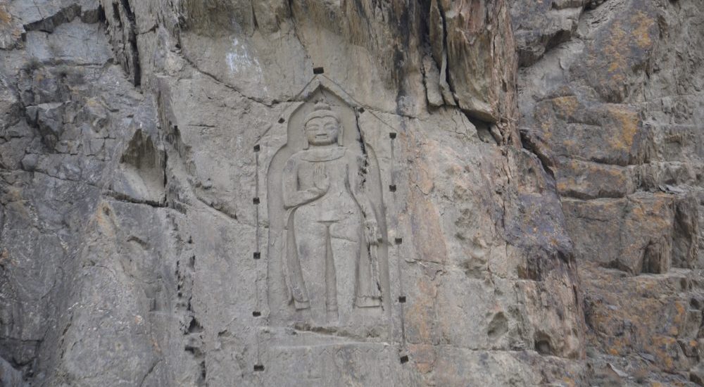
Kargah Buddha: A 7th-Century Marvel Carved in Rock At the center of Gilgit-Baltistan, Pakistan, resides an extraordinary testament to ancient artistry and spirituality – the Kargah Buddha. Carved with precision into solid rock, this majestic Buddha figure from the 7th century stands an impressive 15 feet tall and 5 feet wide, perched about 150 feet above the ground. It is situated in the scenic Kargah Nullah ravine, to the west of Gilgit city. The Kargah Buddha explicitly serves as a symbol of the region’s intricate historical, cultural, and religious heritage. Gilgit: A Hub of History and Trade Gilgit is the headquarters of the Gilgit-Baltistan region of Pakistan. The magnificent city is perched at the confluence of the Gilgit River and Hunza River, near the Junction point of three great mountain ranges. Gilgit’s historical position on the Silk Route has undoubtedly bestowed upon it a legacy of cultural diversity, religious pluralism, and historical significance. The town’s role as a trade hub and cultural crossroads has undoubtedly left a lasting impact on its history. At the same time, the city stands as a testament to the dynamic interactions that shaped the course of history at this strategic crossroads of civilizations. Various phases in the history Gilgit underwent are: Silk Route Connection: As a key point on the Silk Route, Gilgit played a crucial role in the exchange of goods, ideas, and cultures between East and West. The town served as a melting pot where diverse civilizations converged, fostering a vibrant atmosphere of cultural exchange. Buddhism in Gilgit: The period from the 3rd to the 11th century marked Gilgit as a prominent center of early Buddhism. The presence of a Buddhist monastery and stupas with Sanskrit manuscripts attests to the town’s role in the spread of Buddhism. At the same time, the constant movement of religious caravans along the Silk Route contributed to the establishment and growth of Buddhism in the region. Power Struggles: The historical narrative of Gilgit is marked by power struggles among various empires and dynasties, including the Tibetan Empire, the Kashmiri Karkota Dynasty, and the Umayyad and Abbasid caliphates. These political dynamics shaped the region’s destiny and influenced its cultural landscape. Dardistan and Islamization: By the 11th century, Gilgit had evolved into the autonomous kingdom of Dardistan. The adoption of Islam during this period significantly transformed the religious and cultural fabric of the region. The process of Islamization added another layer to the diverse cultural history of Gilgit. Cultural and Religious Interactions: The Silk Route not only facilitated the trade of goods but also enabled the intermingling of cultures and religions. Gilgit served as a meeting point for people from China, Central Asia, Kashmir, Tibet, Afghanistan, Iran, and India. This interaction contributed to the cultural diversity and pluralism that characterize the region. Archaeological Discoveries: The excavation of a Buddhist monastery and stupas with Sanskrit manuscripts in 1931 showcases the rich archaeological heritage of Gilgit. These discoveries provide valuable insights into the town’s historical importance and its connections to early Buddhist communities. Tracing the Buddhist Legacy in Gilgit-Baltistan Gilgit-Baltistan has served as a meeting point for various cultures, religions, and civilizations over centuries. Before the advent of Islam in the area, the inhabitants followed Buddhism or various indigenous pagan religions. The infusion of a diverse cultural legacy and the dissemination of Buddhism in Gilgit and its neighboring areas are intricately connected to the activities along the Silk Route. Historical records indicate that traveling Buddhist caravans would often take respite in a monastery in Gilgit. The Kargah Buddha, known as Yashani in the local language, stands as a testament to this rich historical and cultural intersection. The Karakoram Highway (KKH), which predominantly follows the ancient Silk Route, offers an intriguing glimpse into the past. The KKH attests to the enduring influence of Buddhism in the region. It is adorned with over 10,000 images of Buddha, Stupas, animals, and inscriptions in more than ten languages. This cultural dominance persisted from the 1st to the 7th century A.D. The Kargah Buddha, situated in Gilgit, is an integral part of this rock art ensemble, serving as a symbol of Buddhism’s prevalence in the area. The carving of the Buddha image into the rock was an act of devotion and reverence, with religious rituals and worship conducted at this sacred site. It stands as a testament to the profound impact of Buddhism on the culture and spirituality of Gilgit-Baltistan. The Unearthed History: Kargah Buddha’s Discovery Archaeological evidence spanning across Gilgit Baltistan (GB) indicates that the region was under the influence of Buddhism from the 3rd to the 11th century AD, with Buddhists engraving sculptures, including that of Buddha, as a form of homage to Gautama Buddha. Some historians propose that the propagation of Buddhism in GB occurred during the rule of two Kashmiri monarchs, Yakha and Yakhani. The Buddha sculpture in Kargah is believed to have been crafted in memory of Yakhani by a group of monks. Over time, the term Yakhani evolved into Yashani. Despite these historical accounts, Gilgit’s folklore features numerous myths about the Buddha that challenge both archaeological and historical findings. The revelation of the Kargah Buddha took place in 1938-39, unveiling a sculpture thought to originate from the 4th century AD. Archaeologists unearthed this notable artifact during the same timeframe. The sculpture depicts Buddha with his right hand on his chest in the Abhayamudra, a fearless pose, while the left-hand hangs straight, conveying a message of peace. The image features a broad and squarish face with extended ears, a flat nose, a wide mouth, compressed lips, and hair arranged tightly in a skull-like fashion. The archaeological exploration also led to the discovery of the remains of a Buddhist monastery and three stupas, situated approximately 400 meters upriver from the Buddha. This discovery followed the revelation of the renowned Gilgit manuscripts in 1931. These manuscripts, written in Sanskrit, shed light on local rulers and revered pilgrims. Moreover, the manuscripts offer compelling evidence of a flourishing scholarly community in the region. It is worth noting

Kargah Buddha Read Post »

, , , , , , , , , , , , , , , , ,
Scroll to Top