Author name: admin

Tomb of Asif Khan
Heritage Sites in Pakistan, Punjab, Tombs

Tomb of Asif Khan

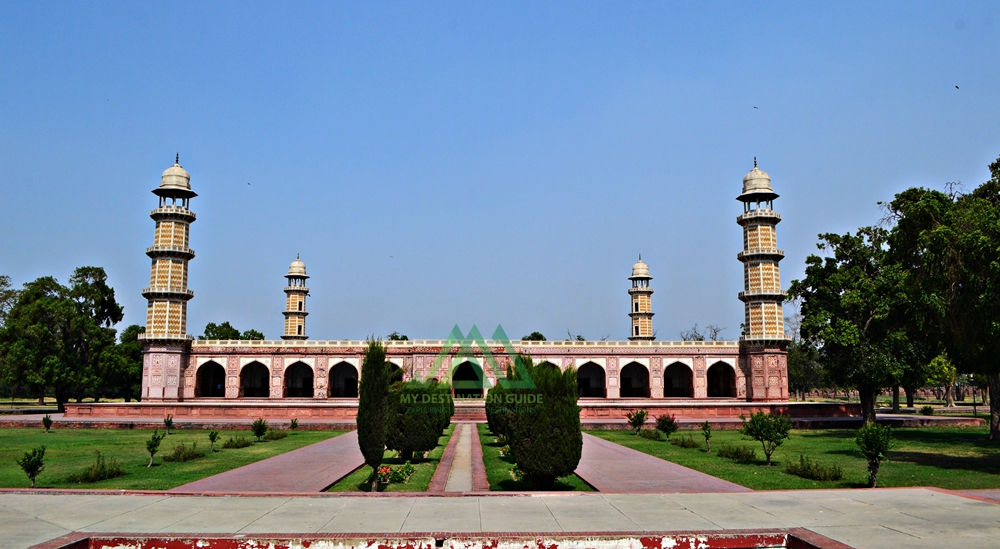
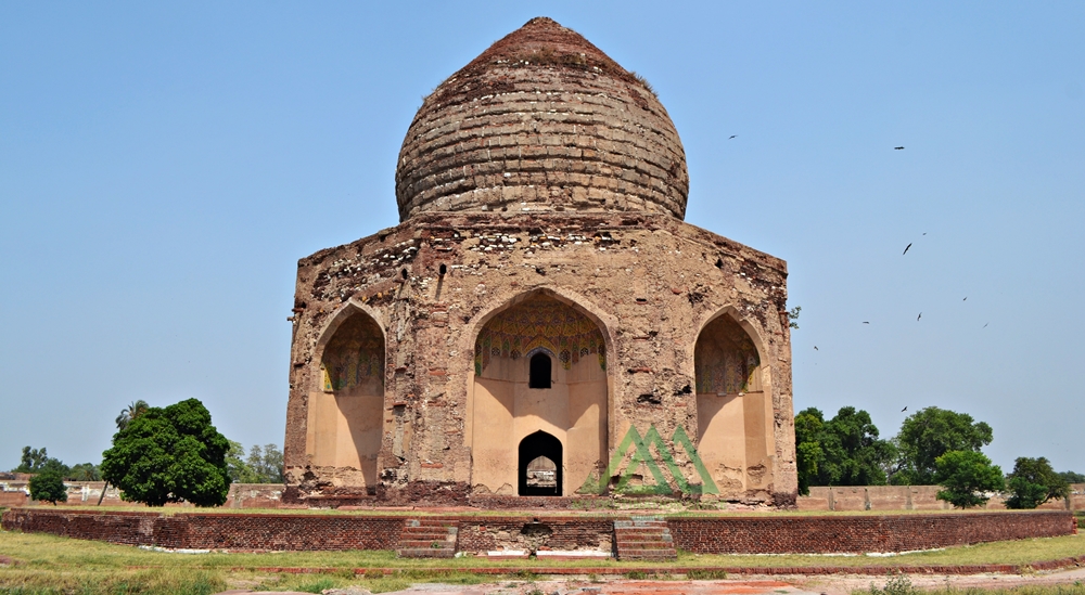
Keyword-Rich Content” Exploring the Magnificent Tomb of Asif Khan in Lahore, Pakistan Unveiling the Rich History and Architecture of Asif Khan’s Tomb In the heart of Lahore, Punjab, Pakistan, lies a magnificent edifice – the Tomb of Asif Khan. This splendid architectural marvel stands as a testament to the opulence of the Mughal era. It is adorned with a high bulbous dome, reminiscent of a bygone era when craftsmanship and design were paramount. Asif Khan: A Man of Influence Asif Khan, known by the title Asif Khan, was none other than the esteemed Mughal statesman Mirza Abdul Hassan Jah, also recognized as Asif Jah. He held a significant place in the Mughal hierarchy, being the brother of Empress Noor Jahan, the father of Arjumand Bano Begum (famously known as Mumtaz Mahal, the beloved of Emperor Shah Jahan), and the brother-in-law of Mughal Emperor Jahangir. His illustrious career saw him rise to the position of Khan e Khana, commander in chief, and eventually, the governor of Lahore. Tragically, Asif Khan met his end in a battle against the forces of the rebel Raja Jagat Singh in 1641. It was Emperor Shah Jahan who commissioned the construction of this remarkable tomb in his honor. The endeavor cost a staggering 300,000 rupees and took four years, from 1641 to 1645, to reach completion. Notably, Asif Khan’s tomb stands in close proximity to Jahangir’s tomb, forming an axis of historical significance. The Garden of Paradise The Tomb of Asif Khan is set within a picturesque garden measuring 300 yards on each side. This garden follows the Persian Chahar Bagh system, characterized by four squares divided by long pools and pathways. Each square is adorned with fountains, water reservoirs, and scenic trails. Originally, water reservoirs at each corner of the tomb supplied the fountains and pathways with water, creating a tranquil and serene ambiance. Access to the garden is granted through gates on its northern and southern walls. The southern gate, the primary entrance to the complex, is a double-storied structure with intricate red stone and white marble ornamentation. Its interiors feature small chambers, while the central portion boasts a tall two-story iwan portal with stunning stucco work. Likewise, the flooring is a work of art, adorned with geometric brickwork. The northern gate, known as the Jawab (response) gate, is equally impressive, featuring a central arched iwan portal flanked by four smaller portals. Though time has weathered its intricate tile work, the gate still retains an air of grandeur. Additionally, a small mosque within the eastern wall served as a residence during the British era. It provides a glimpse into the tomb’s rich history. Architecture The architecture of Asif Khan’s tomb is a testament to the Central Asian style prevalent during the Mughal era. Standing at the center of the expansive garden, the tomb rests on an elevated podium, accessible by a flight of stairs. Its octagonal shape, with each side measuring 38 feet 8 inches, offers access from eight sides, each featuring an arched window offering a glimpse into the tomb’s interior. Similarly, deeply recessed iwans or alcoves grace each side of the tomb. The exterior of the tomb originally boasted red sandstone and intricate marble stone inlay work. Stucco tracery and blue Kashi tiles adorned its walls. The dome, a distinctive feature initiated by Emperor Shah Jahan, was originally covered in white marble. This bulbous double dome rests atop the octagonal base, presenting a harmonious blend of form and function. Inside the tomb, the lavish use of white marble, intricate inlay work, stucco designs, tile mosaics, and Ghalib Kari (fine plasterwork) create a mesmerizing visual experience. The inner dome ceiling, intricately decorated with interlacing patterns, adds to the grandeur. The central cenotaph is crafted from pure marble. It is also adorned with inscriptions from the Holy Qur’an and mirrors the nearby tomb of Emperor Jahangir. It stands upon a red limestone floor, known as Sang-e-Abri, although the original material no longer exists. The Sikh Era and Restoration During the rule of the Sikh Empire, Asif Khan’s tomb, along with other historical monuments, suffered significant damage. Notable Sikh rulers like Gujjar Singh, Lahna Singh, and Subha Singh played a role in the deterioration. They even planted large Pipal trees around the tomb, obstructing its view. Some of the stolen marble, decorative stones, and sandstones found their way into the construction of the Golden Temple in Amritsar and the Hazuri Bagh Baradari in Lahore. The original beauty of the tomb was marred during this period, and despite subsequent repairs by the British, it never fully regained its former glory. Flooding in 1955 and 1973 further damaged the walls, leaving the tomb in a disappointing state. Despite its challenges, the Tomb of Asif Khan holds a place on the tentative list as a UNESCO World Heritage Site. It continues to stand as a testament to the rich history and architectural brilliance of the Mughal era. This architectural masterpiece invites visitors to explore its storied past and captivating beauty.

Akbari Sarai from front
Monuments, Punjab

Akbari Sarai

Akbari Sarai: A Marvel of Mughal Architecture in Lahore, Pakistan The enigmatic Akbari Sarai, a treasure trove of Mughal heritage, lies in the heart of Lahore, Punjab, Pakistan. It is nestled gracefully between the magnificent Jahangir’s Tomb and the resplendent Asif Khan’s Tomb. This sprawling oblong-shaped courtyard dates back to 1637. The Sarai boasts a rich history as a haven for travelers and a sanctuary for the guardians of Jahangir’s Tomb. At the same time, it served as a vital postal station known as Dak Chowki. Unveiling the Historical Veil Emperor Shah Jahan’s esteemed court historian, Abdul Hamid Lahori, documented the original designation of this grand edifice as the “Jilu Khana-e-Rauza” (attached court of the tomb) in his magnum opus, “The Padshahnama.” The terminology”Akbari Sarai” emerged during the reign of Islam Shah Suri in the mid-1550s, intriguingly not during the illustrious reign of the Mughal Emperor Akbar. Architectural Marvels Unveiled Spread over a vast expanse of 12 acres, the Akbari Sarai spans an impressive 797 feet by 610 feet. It boasts a perimeter adorned with 180 cells, each featuring a front veranda and a shared passageway. The Sarai’s architectural opulence shines through the presence of four Burjes, each housing intricate chambers. These chambers present an elliptical hall at their forefront, complemented by a veranda and an octagonal chamber at the rear. Access to this architectural wonder is granted through two imposing entrances located to the north and south. These entrances bear the hallmark of Mughal craftsmanship, adorned with captivating frescoes and the exquisite Ghalib Kari. The latter refers to a network of stucco and plaster ribs gracefully applied to the curved surfaces of each archway. Notably, the architectural attributes of the Sarai, including its decorative elements, structural style, and the size of the bricks used in its construction, exhibit the quintessential Mughal aesthetics. Interestingly, the eastern entrance gateway to Jahangir’s tomb is distinguished by its large double-storied iwan. It is further linked with four smaller arched niches, hinting at a concurrent construction period. A Glimpse into the Past Towards the western periphery of the Sarai, amidst the line of cells, rests a mosque dating back to the Suri era. This mosque is characterized by three resplendent domes. Although time has eroded much of its artistic grandeur, the sandstone-facing facade adorned with inlay work still exudes an aura of grace. The cells that grace the complex, along with its ornate gateways, owe their existence to the Shah Jahan period during the mid-1600s. Administrative Marvels The Akbari Sarai, in its heyday, served as an esteemed state guesthouse, overseen by a Shahna (official caretaker) and a team of dedicated assistants. Moreover, the establishment even boasted a resident physician and a skilled baker. Travelers and guests were treated to a range of amenities, including complimentary fodder for their animals, access to both hot and cold water, and comfortable bedsteads. However, as history continued to unfold, the Sarai witnessed various transformations. During the Sikh era, for instance, Maharajah Ranjit Singh repurposed the complex. He converted it into a cantonment for one of his foreign generals, Musa Farangi. Subsequently, during the British colonial period, it took on a new role as a rail depot. Albeit, It suffered significant damage with the construction of a nearby rail line. A Shared UNESCO Dream The Akbari Sarai, along with its illustrious neighbors, Jahangir’s Tomb and the Tomb of Asif Khan, were jointly recognized in 1993 when they were included in the tentative list of UNESCO World Heritage Sites. This recognition underscores their significance as custodians of Mughal history and architectural prowess, captivating the world with their timeless charm. The Akbari Sarai stands as a testament to the glorious Mughal era. It was a period where artistry, architecture, and hospitality converged to create a masterpiece. It continues to enthrall and inspire visitors from around the globe.

Front of the Mughal Emperor Jahangir's Tomb in Lahore
Heritage Sites in Pakistan, Punjab, Tombs

Jahangir’s Tomb

Exploring the Splendor of Jahangir’s Tomb in Lahore, Pakistan Jahangir’s Tomb, a magnificent architectural masterpiece located in Lahore, Pakistan. Situated in Shahdara, on the banks of the Ravi River, it stands as a testament to Mughal grandeur. This tomb is not only a historical marvel but also a symbol of artistic brilliance. Uncovering History The origins of Jahangir’s Tomb can be traced back to the love of Emperor Jahangir and his wife Noor (Nur) Jahan for the lush garden where it now stands. The garden, in fact, known as Dilkusha Garden, was initially established by Nawab Mehdi Qasim, a special curator of Emperor Akbar. It eventually became the Queen of India’s sanctuary, adorned with beautiful trees and fountains. This garden played a crucial role in the lives of Jahangir and Noor Jahan. It served as their point of departure and arrival during their journeys to and from Kashmir. Emperor Nuruddin Salim Jahangir was the fourth Mughal ruler in the subcontinent. He continued his father Akbar’s tradition of making Lahore the center of official affairs. Upon Jahangir’s death in 1627, his body was transported to Dilkusha Garden in Lahore for burial, where the construction of his grand mausoleum would commence. The Marvelous Construction Emperor Shah Jahan is often credited as the head designer of Jahangir’s Tomb. However, many historians believe that his wife Noor Jahan had a significant influence on the project. The Persian influence on the design and her inspiration from her father’s tomb in Agra, the Tomb of Itmad-Ud-Daulah, is apparent in the structure. Noor Jahan not only played a role in the architecture but also in designing the gardens. Later, it became her permanent residence after Jahangir’s passing. Evidence suggests that she personally financed much of the construction. The tomb took a decade to complete, from 1627 to 1637, at a cost of one million rupees of that era. Renovation and Restoration During the Sikh rule, Jahangir’s Tomb faced a period of desecration and damage. It was used for various purposes, including as an army headquarters and a residence. Priceless art within the inner chambers was destroyed and pillaged. Even after the fall of the Mughal empire during the British occupation, the tomb suffered further indignities. It was used for coal dumping during the construction of a railway line during British raj. However, the British later undertook efforts to restore the tomb complex and Akbari Sarai to its former glory. The image of Jahangir’s Tomb even graced the 1,000 Pakistani Rupee note until 2005, a testament to its historical and cultural significance. A Glimpse of the Layout Jahangir’s mausoleum is set within a large quadrangle enclosed by a thick wall, with grand entrances to the west and east. The eastern entrance gate was destroyed due to the river, leaving the western gate as the primary entrance. This gate features a small mosque and is accessible through Akbari Sarai, an enclosure reachable from two gates facing each other to the north and south. The gate’s pietra-dura work, white marble inlaid in red sandstone, remains a masterpiece of artistry. Entering through the gate reveals a garden layout known as the Persian Chahar Bagh scheme, divided into four squares with walkways and water channels, mirroring the paradise gardens of Islamic tradition. A Closer Look at the Architecture Jahangir’s mausoleum, unlike the traditional domed Mughal tombs, features a flat roof, breaking with convention. Standing on a 5-foot high podium, the 22-foot-tall single-story mausoleum boasts a square plan with the main grave surrounded by forty rooms, each uniquely designed. These rooms once served as places for Islamic scholars to recite the Quran, honoring the king’s soul. The corridor surrounding the mausoleum is adorned with elegant mosaics, floral frescoes, and verses from the Quran. Carved marble jali screens allow light to filter in various patterns, facing toward Mecca. The rooftop features intricate marble work on the ceiling. The artwork is reminiscent of a Persian carpet, reflecting the Timurid architectural style from Central Asia. The Towering Minarets Four octagonal minarets rise from the corners, topped with white marble cupolas measuring 100 feet in height. These minarets are adorned with zigzag inlays of white marble and yellow stone. Each minaret, with its five floors, offers a scenic view of the city. The exterior of the mausoleum is clad with red sandstone, featuring rich panel decoration inlaid with marble motifs. The Cenotaph Jahangir’s cenotaph, situated in an octagonal chamber at the center of the mausoleum, is a sight to behold. The floor is adorned with floral designs using various stones, while the walls are adorned with mosaic patterns. The cenotaph itself is a takhtgah, or “throne,” decorated with white marble and precious and semi-precious stones. It features 99 traditional attributes of Allah with pietra dura inlays and Quranic verses on the flat top. The Original Building Some accounts suggest that the tomb structure was originally a three-story building with a Baradari (pavilion with 12 doors) on top, housing Jahangir’s grave amulet. However, during the Sikh rule, several Mughal-era buildings, including parts of Jahangir’s tomb, were dismantled. The Baradari was relocated to Hazuri Bagh, between the Badshahi Mosque and Lahore Fort. While the tomb’s roof was replaced with lime plaster, its historical significance endures. Jahangir’s Tomb in Lahore, Pakistan, is a timeless testament to Mughal artistry and historical significance. Its architectural splendor, lush gardens, and rich history make it a must-visit for anyone interested in the glory of the Mughal Empire. Additionally, the neighboring structures, such as Asif Khan’s tomb and Akbari Sarai, provide deeper insights into the grandeur of a bygone era.

karakoram highway tourist attractions
Blogs, City Breaks, Gilgit-Baltistan, Monuments, Roads & Highways

Karakoram Highway Attractions

The Karakoram Highway (KKH): An Engineering Marvel  The Karakoram Highway (KKH), N-35, stands as one of the greatest wonders of the modern world. It is an awe-inspiring feat of human determination and ingenuity fondly referred to as the 8th wonder of the world. This 887-kilometer highway traverses along the Indus for 310 kilometers. Before meeting the Indus at the confluence of three mighty mountain ranges, it passes through Gilgit, Hunza, and Khunjerab. The highway runs through the Karakoram Range where 12 out of the 30 highest mountains in the world majestically overlook the KKH. Indeed, there is no other highway on earth that can rival the Karakoram Highway’s richness of attractions and breathtaking vistas. Origin and Journey of the Karakoram Highway Spanning an impressive 1300 kilometers (800 miles), the KKH commences its journey from the historic city of Hassan Abdal, approximately 45 kilometers from Islamabad on the Islamabad – Peshawar Highway. Its asphalt ribbon weaves through the cities of Abbottabad and Manshera crosses the majestic River Indus at Thakot, and continues on to Gilgit, meandering through the rugged mountains of Besham, Pattan, Sazin, and Chilas, before gracefully passing through Hunza and Sost. Finally, the highway reaches its zenith at the Khunjerab Pass, standing tall at an astonishing 4,733 meters (15,750 ft) above sea level. This pass, also known as Zero Point, marks the border between Pakistan and China. As the highway continues its journey, it enters the high Central Asian plateau and winds down through the Pamirs until it reaches Kashgar, situated at the western edge of the Taklamakan Desert. Gilgit-Baltistan is a treasure trove of history and natural wonders. It beckons travelers from all corners of the world to witness its splendor. As you explore this enchanting region, you will undoubtedly be captivated by the stories etched into its landscapes and monuments, a testament to the richness of its cultural heritage and the indomitable spirit of its people. Major Attractions along the Karakoram Highway The Karakoram Highway is undoubtedly crowned with a plethora of attractions, showcasing a harmonious blend of ancient rock carvings, awe-inspiring petroglyphs, mesmerizing natural beauty, and remarkable man-made marvels. Here are some of the major Karakoram Highway attractions that continue to captivate travelers from around the globe: The Khyber Pakhtunkhwa Section The Karakoram Highway passes through the plains, lush hills, and barren mountains of the Khyber Pakhtunkhwa before it enters the Himalayan range of Gilgit-Baltistan which boasts the height of the Karakoram Highway Attractions in the region. Mansehra Rock Edicts  Ashoka Rocks MansehraLocated on the north side of the town of Mansehra, the Ashoka Rocks bear witness to history with 14 edicts engraved by order of the Mauryan King Ashoka in the 3rd century BC. Although the Kharoshti script inscription is fading away, shelters have been built to protect this invaluable relic, making it accessible to visitors. The three granite boulders bearing 14 edicts engraved by order of the Mauryan King Ashoka in the 3rd century BC are located on the north side of the town of Mansehra. The inscription bearing Kharoshti script is fading away and almost impossible to see despite the shelters to protect it. Diamer Section: Threshold to Gilgit-Baltistan The Diamer Section runs in the rugged mountains for about 200km starting from the border between Tangir and Kohistan to Jaglot near the junction point of three great mountain ranges where Gilgit River and Indus converge. Shatial Petroglyphs A treasure trove of Buddhist archaeological wonders, the Shatial Rock Art Carvings or Petroglyphs can be found along the Karakoram Highway, previously known as the Old Silk Route. Carved into large rocks, these petroglyphs depict Jataka tales and Stupas, symbolizing the journeys of monks and pilgrims to Gandhara during the Buddhist era. Sadly, the construction of dams like the Diamer-Basha Dam and Dassu Dam has put these carvings in jeopardy, threatening their existence. Thalpan Petroglyphs The town of Chilas is surrounded by striking petroglyphs, particularly the ‘Chilas I’ site, which features inscriptions on both sides of the KKH and is considered a key Karakoram Highway Attraction spot. One of the most striking carvings here is the depiction of a large stupa with flying banners. Across the river, visitors can marvel at stones bearing art showcasing mythical animals, battle scenes, royal lineages, and Buddhist tales. Another site, ‘Chilas II,’ located near the police check post on the KKH, features a huge rock adorned with hunting and battle scenes, a Buddhist stupa, the long-horned ibex, and symbols of fertility. Nanga Parbat View The Thakot Bridge is the base point for an unforgettable journey to Fairy Meadows and the base camp of Nanga Parbat, famously known as the “Killer Mountain”. The bridge is situated approximately 78 kilometers south of Gilgit.  The Thalechi viewpoint offers travelers a perfect spot to pause and admire the sublime beauty of Nanga Parbat. Gems in Gilgit Region Gilgit is the administrative headquarters of Gilgit-Baltistan. The region is enormously blessed with historical monuments and breathtaking natural landscapes.  About 90km section of the Karakoram Highway from Jaglot to Guro (Jaglot) passes through the region. Partab Bridge The Partab Bridge is located about 40 kilometers southeast of Gilgit. It played a crucial role in connecting Gilgit with Bunji, Astore, and Kashmir long before the construction of the Karakoram Highway. Built between 1889 and 1893, this suspension bridge served as a vital communication link and facilitated trade. However, during the 1947 revolt when Gilgit gained independence from Dogra Raj, the bridge was burnt down. Despite facing decades of neglect, it was rebuilt after the 2010 floods, standing as a testament to human resilience. Junction Point of Three Great Mountain Ranges Jaglot, a mere 40 kilometers southeast of Gilgit, hosts the Junction Point of the Three Mountain Ranges. Here, the Karakoram, Himalaya, and the Hindukush converge. This unique location also marks the confluence of the Gilgit and Indus Rivers. About 5 km to the north, the Skardu road diverges from the KKH. Standing at the monument, visitors are treated to splendid views of the meeting of these three

Makran Coastal Highway Attractions
Balochistan, City Breaks, Roads & Highways

Makran Coastal Highway Attractions

Exploring the Marvels of Makran Coastal Highway: A Scenic Journey from Karachi to Gwadar The 653-kilometer highway bearing Makran Coastal Highway attractions is also known as National Highway 10 (N-10). The highway seamlessly connects the western province of Sindh with the picturesque landscapes of southern Balochistan. As we delve into the charm of this coastal road that hugs the Arabian Sea, we’ll uncover its hidden treasures, making your trip an extraordinary adventure. The Makran Coastal Highway: A Game-Changer Before the construction of this splendid highway, the arduous unpaved road journey from Karachi to Gwadar would consume two grueling days. However, with the advent of the Makran Coastal Highway, this travel time has been dramatically slashed to a mere 6-7 hours. The key Makran Coastal Highway Attractions dotted along the Highway are unique in all respects on this game-changer highway. Major attractions include: Zero Point: Where the Journey Begins Located approximately 125 kilometers northwest of Karachi, Zero Point serves as the gateway to two significant routes: the RCD Highway leading north to Baluchistan mainland and the N10 Makran Coastal Highway leading westward to Gwadar. It’s a place where cellular networks cease to function, emphasizing the remote and untamed beauty of this region. At this juncture, you’ll encounter a replica of the “Princess of Hope” rock formation, a testament to the region’s unique geography. Local restaurants and tuck shops offer a taste of authentic cuisine, including tea and cookies. For travelers’ convenience, a mosque and outdoor bathroom facilities are available. Hingol National Park: A Biodiversity Hotspot Stretching across an impressive 1,650 square kilometers along the Makran coast in southwestern Balochistan, Hingol National Park is a haven for nature enthusiasts. Established in 1988, this national park boasts a rich biodiversity, with 250 plant species, 35 species of mammals, 65 species of amphibians and reptiles, and 185 species of birds. It’s a must-visit destination for wildlife aficionados. Hingol Mud Volcanoes: Nature’s Artistry Approximately 200 kilometers west of Karachi and 8 kilometers off the main Coastal Highway, the Hingol mud volcanoes, also known as Chandragup Mud Volcanoes, showcase Mother Nature’s artistic prowess. The ever-erupting clay formations in Hingol National Park create a surreal landscape, making it a sacred site for Hindu worship. Local guides are your best bet for finding these hidden gems. Hinglaj Mandir: An Ancient Pilgrimage Site Situated in the heart of Hingol National Park, Hinglaj Mandir, also known as Hinglaj Mata, is an ancient Hindu temple and one of the world’s oldest. Nestled in a narrow gorge on the west bank of the Hingol River, this sacred site features a small, shapeless stone adorned with Sindoor (Vermilion) and worshipped as Hinglaj Mata. It’s a spiritual journey into the past. Kund Malir Beach: A Slice of Paradise Located around 145 kilometers from Zero Point and 270 kilometers from Karachi, Kund Malir Beach is a pristine coastal gem. Despite the lack of basic facilities like hotels and restaurants, it boasts a serene and soothing environment. The drive along the Coastal Highway becomes a delight as you soak in the breathtaking beauty of this world-renowned beach. Golden Beach: Nature’s Abode Situated just 2 kilometers from Kund Malir Beach, Golden Beach, also known as Malan Beach, is a less-explored paradise. Its limited facilities and steep gradient from the main Coastal Highway make it a quiet escape. Golden Beach is not only a haven for Green Turtles but also a wintering ground for over 50 species of migratory birds, making it a birdwatcher’s delight. Its golden sands and untouched beauty make it an eco-tourism hotspot. Princess of Hope: Nature’s Masterpiece The “Princess of Hope” remained hidden until Hollywood actress Angelina Jolie’s visit in 2002. This naturally carved rock formation, located around 275 kilometers from Karachi, stands tall as a testament to nature’s artistic abilities. Weathering the test of time, it adds a touch of mystery to your journey along the Makran Coastal Highway. The Sphinx of Makran Approximately 150 kilometers from the Zero Point of the Makran Coastal Highway and 280 kilometers from Karachi, you’ll encounter another natural wonder: the Sphinx-like structure. This formation, created by the relentless winds blowing through the region’s muddy hills, bears a resemblance to the Egyptian Sphinx. Although not as sharply shaped, it’s a unique sight worth seeing. Ormara Beach: A Historical Oasis Located about 360 kilometers west of Karachi and 230 kilometers east of Gwadar, Ormara Beach offers a pristine coastline with spectacular sunrise and sunset views. Named after General Ormoz, who accompanied Alexander the Great during his conquests, it holds historical significance. The Haft Talar tourist resort, overlooking the beach, provides a range of outdoor activities, from concerts to bird-watching. Pasni: A Historical Haven Pasni is an important small town and a fishing port in the Arabian Sea. The beachside is off the main Coastal Highway, 40km to the coastal area about 100km short of Gwadar. Pasni is an important small town and a fishing port at the Arabian Sea, off the main Coastal Highway, 40km to the coastal area about 100km short of Gwadar. Its significance relates to the discovery of rock formations including the ancient ruins of the Harappan era the presence of antique Hindu temples, and proofs of Alexander’s passing the coastal belt. Astola Island About 25 km south of the nearest part of the coast and 39 km southeast of the fishing port of Pasni is a small uninhabited island called Astola Island or Jazira Haft Talar. It is known to be the largest offshore Island measuring 6.7 km long and 2.3 km wide, and 246 ft above sea level. The Island is accessible by motorboat in about 5 hours or by helicopter. It is a popular eco-tourism destination with no lodging facilities on the Island. Anyone planning for an overnight stay must carry a tent and food. The Island is famous for scuba diving, fishing, and observing turtle breeding. Gwadar: The Gateway of Wind The term Gwadar is a combination of two Balochi words Gwat (meaning the wind) and Dar (meaning Gateway) thus Gwadar

Shalimar Gardens
Heritage Sites in Pakistan, Monuments, Punjab

Shalimar Gardens

Exploring the Magnificence of Shalimar Gardens in Lahore Unraveling the Marvel of Shalimar Gardens: A UNESCO World Heritage Site The Shalimar Gardens in Lahore stand as an extraordinary testament to Mughal artistry and aesthetics, reaching their zenith during the reign of the Mughal Empire. Commissioned by the visionary Mughal Emperor Shah Jahan, this architectural marvel began its construction on June 12, 1641. It was completed just 18 months later, in 1642. Together with the Lahore Fort, it was designated as a UNESCO World Heritage Site in 1981. Embracing All: From Royalty to the Common Folk While originally intended to serve as an enchanting retreat for royal guests, the Shalimar Gardens welcomed the general public to explore a dedicated section of its lush beauty. The inspiration for these gardens draws from the earlier Shalimar Gardens in Kashmir, built by Emperor Jahangir, the father of Shah Jahan. Remarkably, Shah Jahan himself played an active role in the construction of the Kashmiri gardens. Architectural Grandeur in Nature’s Embrace Covering an expansive 16 hectares, the rectangular garden is enclosed by crenelated walls crafted from red sandstone. It is structured across three terraces, gracefully descending from south to north. Each terrace carries a name infused with meaning: the upper terrace, known as “Farah Baksh,” translates to “Bestower of Pleasure,” the middle terrace, “Faiz Baksh,” means “Bestower of Goodness,” and the lower terrace, “Hayat Baksh,” signifies “Bestower of Life.” 410 Dancing Fountains: A Spectacle of Engineering Mastery The heart of the Shalimar Gardens lies in its 410 fountains, which gracefully rise from the canal, culminating in the marble pools. The hydraulic system that governs these fountains baffles even modern scientists with its ingenious thermal engineering. This engineering brilliance served to cool the air during sweltering summers, offering respite to the garden’s visitors. The upper-level terrace boasts 105 fountains, the middle terrace features 152, and the lower terrace delights with 153. Beyond the Wall: A World Within Within the protective embrace of the garden’s walls, a collection of buildings served diverse purposes. These include: Sawan Bhadun Pavilions Naqar Khana and Its Buildings Khwabgah or Sleeping Chambers Hammam or Royal Bath The Aiwan or Grand Hall Aramgah or Resting Place Khawabgah of Begum Sahib or Dream Place of the Emperor’s Wife Baradaries or Summer Pavilions for Cooling Delight Diwan-e-Khas-o-Aam or Hall of the Special and Ordinary Audience with the Emperor Two Gateways and Minarets Adorning the Corners of the Gardens Nature’s Bounty: A Verdant Oasis The Shalimar Gardens once boasted a lush variety of trees, including Almond, Peach, Apple, Plum, Apricot, Poplar, Cherry, Quince Seedless, Gokcha, Mango, Mulberry, Sapling of Cypress, Shrubs, and Sour and Sweet Oranges. A Historical Odyssey Supervised by the noble Khalilullah Khan in Shah Jahan’s court, the Shalimar Garden project took shape. The garden’s original land belonged to the Arian Mian Family, who were bestowed with the title “Mian” by the Emperor in recognition of their services to the Empire. The Mughal engineers, recognizing the ideal location and soil quality, acquired the land, ultimately leading to the creation of the Shalimar Gardens. The Arian Mian Family retained governance of the garden for 350 years until General Ayub Khan nationalized it, a consequence of their opposition to his imposition of martial law.

Lahore Fort
Forts, Heritage Sites in Pakistan, Punjab

Lahore Fort

Exploring the Majestic Lahore Fort: A Historical Masterpiece Lahore Fort, locally known as Shahi Qila, is a magnificent architectural marvel situated in the northwestern corner of Lahore’s historic city. This royal fort is not only a testament to its rich history but also stands as an architectural gem. The fort covers an expansive area of nearly 20 hectares, with dimensions measuring approximately 427 meters from east to west and 335 meters from north to south. It’s important to note that these measurements exclude the outer fortification wall added during Maharaja Ranjit Singh’s Sikh rule (1799 – 1839 A.D). A Storied Past The site of the modern Lahore Fort has witnessed centuries of history. Its origins date back to the 11th century when a mud-brick fort was first recorded during Mahmud of Ghazni’s rule. Over the centuries, the fort underwent numerous cycles of destruction, demolition, and reconstruction by various conquerors and rulers before falling under the domain of the Mughal emperors. In 1241, Mongols demolished the fort, and Sultan Balban of the Delhi Sultanate initiated its reconstruction in 1267. However, in 1398, Timur’s invading forces razed it to the ground once more, only for it to be resurrected by Mubarak Shah Sayyid in 1421. During the 1430s, the fort came under the occupation of Shaikh Ali of Kabul before ultimately falling under the control of the Pashtun Sultans of the Lodi dynasty. In 1524, the Mughal Emperor Babur captured Lahore, marking the start of its Mughal legacy. The occupation persisted until the decline of the Mughal dynasty. Subsequently, the Sikhs and later the British took control of the fort. Mughal Magnificence The foundations of the Lahore Fort as we know it today were laid in 1566 during the reign of Emperor Akbar (1556–1605), who made Lahore his capital. Akbar introduced architectural modifications to the fort, incorporating Hindu motifs into its design. Successive Mughal emperors, including Shah Jahan, left their mark on the fort. Shah Jahan, for instance, adorned it with luxurious marble featuring intricate Persian floral designs. In the 17th century, the fort underwent a comprehensive reconstruction, coinciding with the zenith of the Mughal Empire’s prestige and prosperity. Distinct Sections and Prominent Monuments The Lahore Fort is situated in close proximity to the Badshahi Mosque, separated only by the Hazuri Bagh. The fort comprises two primary sections: the northern half, which served as the private and residential area, and the southern half, designated for royal audiences and administrative functions. Within the fort, several notable monuments stand as testaments to its historical significance: 1-Akbari Gate (Masti Gate) Built by Emperor Akbar in 1566, this gate later became known as Masti Gate. Actually, the Empress of Akbar built a mosque outside this gate in 1614 A.D that still exists in good condition. The word” Masjid” (Mosque) in the local version was corruptly pronounced Maseet and transformed as Masti; thus the name Masti Gate was affixed. The fort during Akbar’s times had two gates including Masti Gate. The other gate was later replaced by Alamgiri Gate in 1673 A.D. 2-Alamgiri Gate The iconic Alamgiri Gate, located on its western side, opens in the Hazuri Bagh and faces the renowned Badshahi Mosque, was the masterpiece built by the last of the Mughal ruler Aurangzeb (ruled: 1658 – 1707 A.D) in 1673-74 a private entrance to the royal quarters enabling the elephants carrying members of the royal household enter at one time. It has two semi-circular bastions decorated with lotus petal designs at the base. 3-Diwan-i-Aam (Hall of Public Audience) Diwan-i-Aam is a forty-pillar complex built under the supervision of Asif Khan (brother of Nur Jahan – the empress of Shah Jahan’s father, Jahangir). It was built during the reign of Shah Jahan in 1631 to receive official visitors, make a daily public appearance to address the issues, and review parades. It was demolished when Ranjit Singh’s son Sher Singh bombarded Lahore Fort. The fort was destroyed with light guns during a fight against Chand Kaur, the widow of Kharak Singh (the elder son of Ranjit Singh). After the occupation of the fort in 1849 A.D. The British rebuilt Diwan-i-Aam. 4-Jahangir Quadrangles The northeast corner of the fort is made up of Jahangir’s Quadrangles. The construction of the Quadrangles started during the tenure of Akbar in 1617-18. However, it was completed by Jahangir in 1620 at a cost of seven lacs (Seven Hundred Thousand) rupees. The design of the Quadrangles reflects Akbar’s influence as it employs column brackets carved in the form of animals. Moreover, the quadrangle’s layout differs from the mainstream Mughal quadrangles and its features reflect Hindu temple architecture referring the Akbar’s policy of tolerance. Usually, the Mughal quadrangles used the layout of a Persian paradise garden, and instead, it is formed by concentric rectangles with a fountain in its center. 5-Diwan-i-Khas (Hall of Private Audience) Diwan-i-Khas is a hall commissioned by Shah Jahan where state guests were received and discussed matters related to the state. It is an arched pavilion built in semi-chaste marble and its parapet was decorated with pietra dura work (by inlaying semi-precious stones into white marble). 6-Khwabgah-e-Jahangir (Jahangir’s sleeping chamber) The north end of the quadrangle is dominated by the Barri Khwabgah, or ‘large bedroom’. It was Jahangir’s sleeping chamber attributed to Jahangir’s period and is located in the residential section. The current building is the reconstruction version from the British era. It is now used as a museum housing Mughal antiquities. 7-Khwabgah-e- Shah Jahan It was the sleeping chamber and the first building built by Shah Jahan under the supervision of Wazir Khan in 1634 during his first visit to the city. The Khwabgah comprises five sleeping chambers aligned in a single row. The carved marble screens inside the chambers are decorated with inlaid white marble and frescoes. The incised work known as Ghalib Kari in Urdu and the stucco tracery on the arches of this monument are the main features of this building.  Its original decorations have gone astray presently except for a trace of the

Danyore Rock inscriptions
Gilgit-Baltistan

Danyore Rock Inscriptions

Danyore Rock Inscriptions: A Journey through Time The boulder bearing the Danyore Rock Inscriptions nestles amidst the breathtaking landscapes of Danyore. It is just a stone’s throw away from Gilgit city in Gilgit-Baltistan, Pakistan. These ancient engravings provide a captivating glimpse into the 7th and 8th centuries. However, despite its historical significance, this hidden gem remains shrouded in obscurity. It was known primarily to a select few involved in the fields of archaeology and tourism. Danyore: Where History Meets Natural Beauty Danyore is situated along the iconic Karakoram Highway leading to Hunza, south of Gilgit. It boasts a scenic setting nestled between the Gilgit River and the Hunza River. While the journey from Gilgit to Danyore is a mere 10-minute drive, locating the exact site of the Danyore Rock Inscriptions can prove to be a challenge. Additionally, the signage on the KKH guiding visitors has vanished. Moreover, the boulder itself is tucked away on a narrow street within the premises of a private residence. Surprisingly, the current occupants of the house are unaware of the historical significance concealed within their walls. The Enigmatic Inscriptions This colossal rock measures an impressive 13 x 7 feet. It proudly bears the names of Tibetan monarchs who once held sway over Gilgit during the 7th and 8th centuries. These names are meticulously inscribed in a five-line Sanskrit script, utilizing the late Brahmi script. Dr. Ahmed Hasan Dani, a renowned Pakistani archaeologist, posits that Prince Kumaramatya, a scion of the lineage mentioned in the Hatun inscription of the Ghizer Valley, likely commissioned these inscriptions. The inscriptions bestow royal titles upon Jayamangala Vikramaditya Nandi of the Vikramaditya family, crowning him as Patola Shahi Shahanushahi and Parama-Bhattaraka. Unraveling the Purpose Dr. Dani’s research suggests that the Danyore Rock Inscriptions may have served as a commemoration of a local ruler’s triumph. It may possibly signify the defeat of a Tibetan incursion in the upper Indus Valley. It is also documented that the Kingdom of Great and Little Bolor came under Tibetan suzerainty around A.D. 725.  Unfortunately, the ravages of time have taken a toll on the rock, causing the inscriptions to fade significantly. Nevertheless, it remains a poignant testament to the historical prominence of Sanskrit in the region and a priceless artifact that demands preservation. A Portal to Ancient Gilgit-Baltistan The Danyore Rock Inscriptions open a mesmerizing gateway into the ancient history and cultural heritage of Gilgit-Baltistan. As we stand in awe of these ancient carvings, it becomes evident that this land was once a vibrant center of civilization. It marks the influence of Tibetan rulers and the prevalence of Sanskrit as a dominant language. Basically, safeguarding these inscriptions and promoting awareness of their significance are vital steps in preserving the region’s historical legacy for generations to come. In the tranquility of Danyore, the Danyore Rock Inscriptions silently bear witness to a bygone era. Concealed within the heart of this town, these age-old engravings transport us through time, illuminating the rich history and cultural tapestry of Gilgit-Baltistan. Let us acknowledge the paramount importance of these inscriptions and unite in their conservation, ensuring that the legacy of our forebears endures for countless years ahead. FAQs (Frequently Asked Questions)What are the Danyore Rock Inscriptions? The Danyore Rock Inscriptions are ancient carvings on a large boulder located in Danyore, Gilgit-Baltistan, Pakistan. These inscriptions date back to the 7th and 8th centuries A.D. and bear the names of Tibetan kings who ruled Gilgit during that era. Where exactly are the Danyore Rock Inscriptions located? The Danyore Rock Inscriptions are situated on the premises of a private house in Danyore, across Gilgit City. The town of Danyore is easily accessible from Gilgit, and the rock can be found off the main Karakoram Highway, leading through a narrow street to the private house. What language are the inscriptions written in? The inscriptions on the rock are written in Sanskrit, using the late Brahmi script. Moreover, the five-line inscription reveals the names of Tibetan rulers and confers royal titles upon them. Why are the Danyore Rock Inscriptions significant? These inscriptions provide valuable insights into the ancient history of the region, particularly the rule of Tibetan kings in Gilgit during the 7th and 8th centuries. They offer evidence of Sanskrit’s presence in the area and commemorate the achievements or conquests of the rulers. What efforts are being made to preserve the Danyore Rock Inscriptions? Due to the limited knowledge of the inscriptions’ significance, preservation efforts have been minimal. However, raising awareness about their historical importance is a need of the time. It is possible through collaboration with local authorities and heritage organizations to ensure the conservation of this valuable archaeological site. Remember, the Danyore Rock Inscriptions are a fragile piece of history, and it is our responsibility to protect and cherish them for future generations to appreciate.

Fort of Nawabs of Bahawalpur
Forts, Punjab

Derawar Fort

Explore the Majestic Derawar Fort in Southern Punjab, Pakistan Discovering the Grandeur of Derawar Fort Derawar Fort, also known as Qila Derawar, stands as an imposing citadel in the heart of Bahawalpur district. To be exact, the fort is located at the fringes of the Cholistan Desert in southern Punjab, Pakistan. Its formidable square structure rises dominantly amidst the vast semi-desert landscape, captivating the eye from miles away. Bathed in a golden hue, especially during the early morning’s gentle embrace and the enchanting sunsets, Derawar Fort stands tall, surpassing other Nawab Palaces in architectural grandeur. This iconic landmark promises an exhilarating journey from the city center and should be a top destination for any traveler. A Glimpse into the Past Derawar Fort has a rich historical legacy, dating back to the 9th century. Rai Jajja Bhati, a Hindu Rajput hailing from Jaisalmer in the Rajasthan state of India, commissioned the construction of the fort. In 1733, the Abbasi Nawab of Bahawalpur, Sir Sadeq Mohammad Khan I, seized control of the fort. Under his rule, the fort underwent significant renovations, culminating in its current majestic appearance. It briefly fell into obscurity during Bahawal Khan’s focus on Shikarpur. However, Nawab Mubarak Khan recaptured the fort in 1804. The Enigmatic Cholistan Desert Surrounding Derawar Fort is the Cholistan Desert. It spans an impressive 26,000 square kilometers (10,000 square miles) and extends into India’s Thar Desert. In the past, this arid expanse was nourished by the Hakra River, known as the Sarasvati in Vedic times. Until 1960, when the Sutlej River was diverted, Derawar continued to be watered by a canal. However, with time, it was forsaken and left to wither away. Today, the fort bears the scars of time, and the surrounding desert conceals numerous archaeological treasures, many dating back to the Indus Valley Civilization, along the dried-up river’s 500-kilometer stretch. Architectural Marvel The fort itself is a striking sight, constructed with red bricks and fortified by walls that are an impressive 5 feet thick and 30 meters high, punctuated by a series of bastions on each side. These bastions feature intricate geometric designs crafted from burnt bricks. Measuring 1500 meters in circumference, with each side spanning 204.8 meters, the square fort stands as a testament to robustness and grandeur. Within the fort’s precincts, one can find several buildings, including quarters once occupied by the royal family and those designated for the Nawab’s army. Sadly, these structures now stand deserted, slowly succumbing to the relentless march of time. There are two antique cannons displayed on pedestals in the fort’s dusty courtyard. On the western side, small underground cells lie abandoned, inhabited by bats, and ravaged by termites. It’s worth noting that Derawar Fort’s external appearance far surpasses its interior charm. The Resplendent Derawar Mosque Adjacent to the fort lies the impressive Derawar Mosque, a striking replica of the Moti Mosque at Delhi’s Red Fort, built in 1844 AD. Furthermore, nearby, you’ll find the magnificent burial ground of the Nawabs’ family. Visiting this burial site requires prior permission, so plan accordingly. Nearby, there are some shops, but all visitors should make prior arrangements for food, drinks, and other necessities. How to Reach Derawar Fort Derawar Fort is situated approximately 45 kilometers from Ahmed Pur East (Dera Nawab Sahib) and about 95 kilometers from the city of Bahawalpur. The journey takes approximately 3 hours, and it’s advisable to use a 4WD vehicle for this excursion. To gain access to the fort and the royal graveyard, you must obtain prior permission from the current Amir of Bahawalpur. Derawar Fort stands as a testament to history and architectural grandeur amidst the stark beauty of the Cholistan Desert. Exploring this remarkable fortress and its surroundings promises an unforgettable adventure, making it a must-visit destination for anyone seeking to immerse themselves in Pakistan’s rich cultural heritage and natural splendor.

Phander Lake
Gilgit-Baltistan, Lakes, Tourists Destinations in Pakistan

Phander Lake

Exploring Phander Lake: A Jewel in Gilgit-Baltistan’s Crown The Phunder Lake is located in the Phunder Valley of Ghizer District in Gilgit-Baltistan, Pakistan. The lake sits at an impressive altitude of 11,500 feet (3,505 meters) above sea level. The Phunder Lake graces the enchanting Phander Valley in the Ghizer district of Gilgit-Baltistan, Pakistan. This captivating lake not only serves as a vital freshwater reservoir but also hosts thriving populations of trout. Thanks to its primary source, the Ghizer River which is abundant in Trout Fish. Situated on the picturesque Gilgit-Chitral Road, Phunder Lake is a pivotal gateway to the Chitral district. The lake also falls on the way to Shandur Pass, where the illustrious Shandur Polo Festival unfolds annually. Nango Chatt: The Local Gem Known to the locals as Nango Chatt, Phander Lake is an embodiment of tranquility and natural grandeur. Its crystal-clear waters, plunging to an astounding depth of 44 meters. The lake is teemed with lush aquatic flora and plants even visible even from a distance. The lake’s periphery boasts a stunning border of poplar trees, enhancing its overall charm. Snuggled amidst imposing mountains and verdant valleys, Phander Lake finds itself nestled between two imposing ridges. The entire scenery offers a breathtaking panorama of the valley and the lake itself. One end of the lake is enclosed, while the other serves as the primary inlet, continuously replenishing the lake’s pristine waters from the river. A Seasonal Spectacle Phander Lake transforms into a canvas of ever-changing beauty throughout the year, making it a magnet for nature enthusiasts and thrill-seekers alike. On the western ridge, you’ll discover a government rest house, while the eastern ridge is home to a modest cluster of PTDC Motels, both providing unrivaled vistas of the lake and the cascading valleys below. The narrow western ridge, separating the valley from the lake, offers sweeping views of the entire expanse. A Haven for Explorers Phander Valley is a treasure trove for day-trippers and overnight adventurers. Beyond the scenic landscapes, the local cuisine steals the spotlight, with its delectable trout fish, organic vegetables, and a variety of fruits that tantalize the taste buds. Accessible from Both Ends Phander Lake enjoys a strategic location at the crossroads between Gilgit and Chitral, making it easily accessible from either direction. From Gilgit, the journey spans approximately 173 kilometers, with a travel time of around 5 hours, promising a scenic drive through this mesmerizing region. Renovation of Gilgit-Chitral Road is in progress. The completion of the project will ultimately reduce the travel time from 5 hours to about 3 hours.

Scroll to Top