Roads & Highways

Kaghan Valley Tourist Attractions
Khyber Pakhtunkhwa, Others, Roads & Highways, Tourism Blogs

Kaghan Valley Attractions

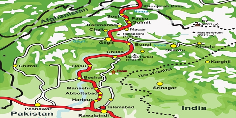
The Kaghan Valley Attractions: A Guide to Its Breathtaking Landscape The Kaghan Valley: Nature’s Marvel in the Heart of Pakistan Nestled within the Mansehra district of Khyber Pakhtunkhwa, Pakistan, the Kaghan Valley is a captivating alpine haven. Spanning a distance of 160 kilometers from its lowest point at 650 meters to the towering Babusar Pass, standing proud at 4170 meters, the Kaghan Valley Attractions speak louder than words. This picturesque valley, a cherished summer retreat, boasts a landscape adorned with lush greenery, majestic Himalayan peaks, and glistening alpine lakes. It’s a realm where nature’s splendor unfurls at every turn, offering a refuge from the mundane. In the embrace of the Kaghan Valley, nature’s symphony resounds in every sight and sound. From cascading waterfalls to alpine lakes, from towering peaks to lush meadows, this haven promises an escape like no other. Embark on a journey of discovery, where adventure and tranquility converge, and the heart finds solace amidst nature’s grandeur. The Kaghan Valley Attractions await an open invitation to experience the magic of Pakistan’s pristine landscapes. As a seasoned traveler, you’ll find the Kaghan Valley Attractions as an alluring sanctuary, rich in diverse attractions that promise an unforgettable escape. Embarking on a Journey through the Kaghan Valley Heading East: Azad Jammu & Kashmir Beckons To the valley’s east lies the captivating realm of Azad Jammu & Kashmir, a mesmerizing expanse that beckons with its charm. This region, a tapestry of beauty, awaits those who seek to explore its hidden gems and immerse themselves in its natural wonders. Towards the North: The Allure of Gilgit-Baltistan Northward, the Kaghan Valley borders Gilgit-Baltistan, an awe-inspiring land where towering peaks and untamed landscapes await intrepid souls. Here, adventure and exploration intertwine, presenting a gateway to uncharted territories and unforgettable experiences. KIWAI: Where Beauty and Adventure Converge The first of Kaghan Valley Attractions, you’ll encounter the charming town of Kiwai, nestled approximately 24 kilometers from Balakot. A gateway to wonder, Kiwai boasts dense pine forests and the allure of its cascading waterfall. This haven is not only a resting point but a realm of enchantment, captivating the hearts of travelers with its natural allure and invigorating ambiance. SHOGRAN: Nature’s Haven of Tranquility Nestled within the captivating Kaghan Valley, Shogran emerges as a highly sought-after destination for tourists. This idyllic haven, perched at an impressive altitude of approximately 2,362 meters (7,749 feet) above sea level, offers a retreat into a world of unparalleled natural splendor. The allure of Shogran lies in its scenic magnificence, attracting nature enthusiasts and adventure seekers alike. This picturesque valley, accessible via the Naran-Gilgit Road at Kiwai, beckons you to explore its myriad wonders. As you ascend to Shogran, the air becomes crisper, and the surroundings transform into a spectacle of greenery and tranquility. SIRI & PAYE: A Glimpse of Alpine Grandeur Cradled in the arms of the mountains, Siri Paye stands as a testament to nature’s artistry. This mesmerizing meadow, adorned with a carpet of wildflowers, offers a panoramic spectacle that ignites the imagination. The sweeping views from Siri Paye encompass a symphony of colors, as the meadow transitions with the changing seasons. The allure of Siri and Paye beckons, an enchanting journey through alpine landscapes and breathtaking vistas. Venture forth through a jeep ride or a scenic climb to reach these heights, where lush meadows and awe-inspiring panoramas await. Siri and Paye, a symphony of beauty, are a testament to the valley’s magnificence. KAGHAN VALLEY – NATURE’S SPLENDOR NARAN: Nature’s Tapestry Unveiled The Naran Valley, a portrait of natural splendor, welcomes you with its lush meadows, crystal-clear lakes, and majestic mountains. Engage your senses in outdoor pursuits like trekking, rafting, and camping, as you embrace the valley’s vibrant beauty. Set against a backdrop of towering peaks, Naran Valley paints a vivid picture of summer’s embrace. Captivating Enclaves: Treasures of the Kaghan ValleyLAKE SAIF UL MULOOK: A Fabled Oasis Nestled in the heart of Kaghan Valley lies a mesmerizing gem named after Prince Saif ul Mulook’s romantic escapade with a mountain fairy. At a breathtaking altitude of 3224 meters, the legendary Saif ul Mulook Lake stands tall as a prime focal point, the 9-kilometer unpaved adventurous road greets travelers with a thrilling 45-minute adventurous jeep ride. The very heart of Saif ul Mulook Lake is its oval-shaped expanse of crystalline waters stretching over a mile serving as a mirror to the grandeur that surrounds it. Reflecting the snow-covered magnificence of the encircling mountains, the lake’s surface shimmers with an ethereal glow, a sight that beckons wanderers and adventure enthusiasts alike. The lake stands as a gateway to boundless adventure and serves as a launching pad for the exhilarating trek to Ansoo Lake. LALAZAR: A Verdant Paradise Beckons Discover the captivating allure of Lalazar, a breathtakingly beautiful plateau nestled at an impressive elevation of 3,130 meters. Situated a mere 20 kilometers away from the charming town of Naran, Lalazar boasts a verdant expanse adorned with an array of vibrant wildflowers, creating a stunning natural tapestry that beckons travelers seeking an escape into nature’s embrace. The 16-kilometer stretch from Naran to Jalkhar presents a well-paved route, ensuring a smooth and comfortable ride for travelers. However, the subsequent 4-kilometer segment from Jalkhar to Lalazar is an uphill ascent along an unpaved, zig-zagging road that adds an element of thrill and excitement to the expedition. This remarkable tourist haven offers panoramic vistas of the valley, treating visitors to an awe-inspiring display of natural grandeur that resides within the upper reaches of the Kaghan Valley. BATAKUNDI and Beyond: Embracing the Heights If you’re seeking an extraordinary escape from the mundane, look no further than the hidden gem of Batakundi. Nestled just 15 kilometers east of Naran, Batakundi is a haven for nature enthusiasts and those in search of tranquility. With its awe-inspiring mountain vistas and tranquil surroundings, Batakundi stands out as the perfect destination for your next retreat. Batakundi offers an idyllic retreat surrounded by nature’s finest elements. The towering mountains and lush greenery create a

karakoram highway tourist attractions
City Breaks, Gilgit-Baltistan, Monuments, Roads & Highways, Tourism Blogs

Karakoram Highway Attractions

The Karakoram Highway (KKH): An Engineering Marvel  The Karakoram Highway (KKH), N-35, stands as one of the greatest wonders of the modern world. It is an awe-inspiring feat of human determination and ingenuity fondly referred to as the 8th wonder of the world. This 887-kilometer highway traverses along the Indus for 310 kilometers. Before meeting the Indus at the confluence of three mighty mountain ranges, it passes through Gilgit, Hunza, and Khunjerab. The highway runs through the Karakoram Range where 12 out of the 30 highest mountains in the world majestically overlook the KKH. Indeed, there is no other highway on earth that can rival the Karakoram Highway’s richness of attractions and breathtaking vistas. Origin and Journey of the Karakoram Highway Spanning an impressive 1300 kilometers (800 miles), the KKH commences its journey from the historic city of Hassan Abdal, approximately 45 kilometers from Islamabad on the Islamabad – Peshawar Highway. Its asphalt ribbon weaves through the cities of Abbottabad and Manshera crosses the majestic River Indus at Thakot, and continues on to Gilgit, meandering through the rugged mountains of Besham, Pattan, Sazin, and Chilas, before gracefully passing through Hunza and Sost. Finally, the highway reaches its zenith at the Khunjerab Pass, standing tall at an astonishing 4,733 meters (15,750 ft) above sea level. This pass, also known as Zero Point, marks the border between Pakistan and China. As the highway continues its journey, it enters the high Central Asian plateau and winds down through the Pamirs until it reaches Kashgar, situated at the western edge of the Taklamakan Desert. Gilgit-Baltistan is a treasure trove of history and natural wonders. It beckons travelers from all corners of the world to witness its splendor. As you explore this enchanting region, you will undoubtedly be captivated by the stories etched into its landscapes and monuments, a testament to the richness of its cultural heritage and the indomitable spirit of its people. Major Attractions along the Karakoram Highway The Karakoram Highway is undoubtedly crowned with a plethora of attractions, showcasing a harmonious blend of ancient rock carvings, awe-inspiring petroglyphs, mesmerizing natural beauty, and remarkable man-made marvels. Here are some of the major Karakoram Highway attractions that continue to captivate travelers from around the globe: The Khyber Pakhtunkhwa Section The Karakoram Highway passes through the plains, lush hills, and barren mountains of the Khyber Pakhtunkhwa before it enters the Himalayan range of Gilgit-Baltistan which boasts the height of the Karakoram Highway Attractions in the region. Mansehra Rock Edicts  Ashoka Rocks MansehraLocated on the north side of the town of Mansehra, the Ashoka Rocks bear witness to history with 14 edicts engraved by order of the Mauryan King Ashoka in the 3rd century BC. Although the Kharoshti script inscription is fading away, shelters have been built to protect this invaluable relic, making it accessible to visitors. The three granite boulders bearing 14 edicts engraved by order of the Mauryan King Ashoka in the 3rd century BC are located on the north side of the town of Mansehra. The inscription bearing Kharoshti script is fading away and almost impossible to see despite the shelters to protect it. Diamer Section: Threshold to Gilgit-Baltistan The Diamer Section runs in the rugged mountains for about 200km starting from the border between Tangir and Kohistan to Jaglot near the junction point of three great mountain ranges where Gilgit River and Indus converge. Shatial Petroglyphs A treasure trove of Buddhist archaeological wonders, the Shatial Rock Art Carvings or Petroglyphs can be found along the Karakoram Highway, previously known as the Old Silk Route. Carved into large rocks, these petroglyphs depict Jataka tales and Stupas, symbolizing the journeys of monks and pilgrims to Gandhara during the Buddhist era. Sadly, the construction of dams like the Diamer-Basha Dam and Dassu Dam has put these carvings in jeopardy, threatening their existence. Thalpan Petroglyphs The town of Chilas is surrounded by striking petroglyphs, particularly the ‘Chilas I’ site, which features inscriptions on both sides of the KKH and is considered a key Karakoram Highway Attraction spot. One of the most striking carvings here is the depiction of a large stupa with flying banners. Across the river, visitors can marvel at stones bearing art showcasing mythical animals, battle scenes, royal lineages, and Buddhist tales. Another site, ‘Chilas II,’ located near the police check post on the KKH, features a huge rock adorned with hunting and battle scenes, a Buddhist stupa, the long-horned ibex, and symbols of fertility. Nanga Parbat View The Thakot Bridge is the base point for an unforgettable journey to Fairy Meadows and the base camp of Nanga Parbat, famously known as the “Killer Mountain”. The bridge is situated approximately 78 kilometers south of Gilgit.  The Thalechi viewpoint offers travelers a perfect spot to pause and admire the sublime beauty of Nanga Parbat. Gems in Gilgit Region Gilgit is the administrative headquarters of Gilgit-Baltistan. The region is enormously blessed with historical monuments and breathtaking natural landscapes.  About 90km section of the Karakoram Highway from Jaglot to Guro (Jaglot) passes through the region. Partab Bridge The Partab Bridge is located about 40 kilometers southeast of Gilgit. It played a crucial role in connecting Gilgit with Bunji, Astore, and Kashmir long before the construction of the Karakoram Highway. Built between 1889 and 1893, this suspension bridge served as a vital communication link and facilitated trade. However, during the 1947 revolt when Gilgit gained independence from Dogra Raj, the bridge was burnt down. Despite facing decades of neglect, it was rebuilt after the 2010 floods, standing as a testament to human resilience. Junction Point of Three Great Mountain Ranges Jaglot, a mere 40 kilometers southeast of Gilgit, hosts the Junction Point of the Three Mountain Ranges. Here, the Karakoram, Himalaya, and the Hindukush converge. This unique location also marks the confluence of the Gilgit and Indus Rivers. About 5 km to the north, the Skardu road diverges from the KKH. Standing at the monument, visitors are treated to splendid views of the meeting of these three

Makran Coastal Highway Attractions
Balochistan, City Breaks, Roads & Highways

Makran Coastal Highway Attractions

Exploring the Marvels of Makran Coastal Highway: A Scenic Journey from Karachi to Gwadar The 653-kilometer highway bearing Makran Coastal Highway attractions is also known as National Highway 10 (N-10). The highway seamlessly connects the western province of Sindh with the picturesque landscapes of southern Balochistan. As we delve into the charm of this coastal road that hugs the Arabian Sea, we’ll uncover its hidden treasures, making your trip an extraordinary adventure. The Makran Coastal Highway: A Game-Changer Before the construction of this splendid highway, the arduous unpaved road journey from Karachi to Gwadar would consume two grueling days. However, with the advent of the Makran Coastal Highway, this travel time has been dramatically slashed to a mere 6-7 hours. The key Makran Coastal Highway Attractions dotted along the Highway are unique in all respects on this game-changer highway. Major attractions include: Zero Point: Where the Journey Begins Located approximately 125 kilometers northwest of Karachi, Zero Point serves as the gateway to two significant routes: the RCD Highway leading north to Baluchistan mainland and the N10 Makran Coastal Highway leading westward to Gwadar. It’s a place where cellular networks cease to function, emphasizing the remote and untamed beauty of this region. At this juncture, you’ll encounter a replica of the “Princess of Hope” rock formation, a testament to the region’s unique geography. Local restaurants and tuck shops offer a taste of authentic cuisine, including tea and cookies. For travelers’ convenience, a mosque and outdoor bathroom facilities are available. Hingol National Park: A Biodiversity Hotspot Stretching across an impressive 1,650 square kilometers along the Makran coast in southwestern Balochistan, Hingol National Park is a haven for nature enthusiasts. Established in 1988, this national park boasts a rich biodiversity, with 250 plant species, 35 species of mammals, 65 species of amphibians and reptiles, and 185 species of birds. It’s a must-visit destination for wildlife aficionados. Hingol Mud Volcanoes: Nature’s Artistry Approximately 200 kilometers west of Karachi and 8 kilometers off the main Coastal Highway, the Hingol mud volcanoes, also known as Chandragup Mud Volcanoes, showcase Mother Nature’s artistic prowess. The ever-erupting clay formations in Hingol National Park create a surreal landscape, making it a sacred site for Hindu worship. Local guides are your best bet for finding these hidden gems. Hinglaj Mandir: An Ancient Pilgrimage Site Situated in the heart of Hingol National Park, Hinglaj Mandir, also known as Hinglaj Mata, is an ancient Hindu temple and one of the world’s oldest. Nestled in a narrow gorge on the west bank of the Hingol River, this sacred site features a small, shapeless stone adorned with Sindoor (Vermilion) and worshipped as Hinglaj Mata. It’s a spiritual journey into the past. Kund Malir Beach: A Slice of Paradise Located around 145 kilometers from Zero Point and 270 kilometers from Karachi, Kund Malir Beach is a pristine coastal gem. Despite the lack of basic facilities like hotels and restaurants, it boasts a serene and soothing environment. The drive along the Coastal Highway becomes a delight as you soak in the breathtaking beauty of this world-renowned beach. Golden Beach: Nature’s Abode Situated just 2 kilometers from Kund Malir Beach, Golden Beach, also known as Malan Beach, is a less-explored paradise. Its limited facilities and steep gradient from the main Coastal Highway make it a quiet escape. Golden Beach is not only a haven for Green Turtles but also a wintering ground for over 50 species of migratory birds, making it a birdwatcher’s delight. Its golden sands and untouched beauty make it an eco-tourism hotspot. Princess of Hope: Nature’s Masterpiece The “Princess of Hope” remained hidden until Hollywood actress Angelina Jolie’s visit in 2002. This naturally carved rock formation, located around 275 kilometers from Karachi, stands tall as a testament to nature’s artistic abilities. Weathering the test of time, it adds a touch of mystery to your journey along the Makran Coastal Highway. The Sphinx of Makran Approximately 150 kilometers from the Zero Point of the Makran Coastal Highway and 280 kilometers from Karachi, you’ll encounter another natural wonder: the Sphinx-like structure. This formation, created by the relentless winds blowing through the region’s muddy hills, bears a resemblance to the Egyptian Sphinx. Although not as sharply shaped, it’s a unique sight worth seeing. Ormara Beach: A Historical Oasis Located about 360 kilometers west of Karachi and 230 kilometers east of Gwadar, Ormara Beach offers a pristine coastline with spectacular sunrise and sunset views. Named after General Ormoz, who accompanied Alexander the Great during his conquests, it holds historical significance. The Haft Talar tourist resort, overlooking the beach, provides a range of outdoor activities, from concerts to bird-watching. Pasni: A Historical Haven Pasni is an important small town and a fishing port in the Arabian Sea. The beachside is off the main Coastal Highway, 40km to the coastal area about 100km short of Gwadar. Pasni is an important small town and a fishing port at the Arabian Sea, off the main Coastal Highway, 40km to the coastal area about 100km short of Gwadar. Its significance relates to the discovery of rock formations including the ancient ruins of the Harappan era the presence of antique Hindu temples, and proofs of Alexander’s passing the coastal belt. Astola Island About 25 km south of the nearest part of the coast and 39 km southeast of the fishing port of Pasni is a small uninhabited island called Astola Island or Jazira Haft Talar. It is known to be the largest offshore Island measuring 6.7 km long and 2.3 km wide, and 246 ft above sea level. The Island is accessible by motorboat in about 5 hours or by helicopter. It is a popular eco-tourism destination with no lodging facilities on the Island. Anyone planning for an overnight stay must carry a tent and food. The Island is famous for scuba diving, fishing, and observing turtle breeding. Gwadar: The Gateway of Wind The term Gwadar is a combination of two Balochi words Gwat (meaning the wind) and Dar (meaning Gateway) thus Gwadar

Makran Coastal Highway connecting Karachi with Gwadar
Balochistan, Roads & Highways

Makran Coastal Highway

Explore the Breathtaking Makran Coastal Highway: A Scenic Coastal Drive Like No OtherThe Makran Coastal Highway or National Highway 10 (N-10) is a scenic highway that stretches across 653 km. The highway runs parallel to the Arabian Sea coast forming a vital link between Karachi in Sindh Province and Gwadar. It further extends to Jiwani near the Iranian border in Balochistan Province, Pakistan. This mesmerizing highway takes you on an unforgettable journey, passing through various attractions, including hidden gems. From natural rock formations like the Princess of Hope and the Sphinx to stretches of serene beaches like Kund Malir, Ormara, Pasni, and Gwadar, the Makran Coastal Highway offers an unparalleled experience. Moreover, it boasts the world’s largest mud volcanoes, and the oldest Hindu shrine – the Nani/Mata/Hinglaj Mandir. Likewise, Hingol National Park, Buzzi Pass, and the fascinating Astola Island make it one of the most scenic coastal drives in the world. Similarly, the WWII Museum in Jiwani is an added beauty. Construction: Connecting Karachi and Gwadar with Ease On December 14, 2004, the construction of the Makran Coastal Highway was completed. It certainly marks a significant milestone in Pakistan’s infrastructure development. Before this highway existed, the journey between Karachi and Gwadar was an arduous two-day drive along a dirt track. The construction, undertaken by the Frontier Works Organization (FWO), drastically changed the scenario, reducing the travel time to a mere 6 to 7 hours. Not only did this cut down travel time, but it also made transportation more affordable. The responsibility for the maintenance of this modern marvel lies with the National Highway Authority of Pakistan. History: Fostering Economic Growth Along the Coast The inception of the Makran Coastal Highway was rooted in the government’s vision to develop infrastructure along the disused coastal line. The objective was to foster economic activities and benefit towns like Ormara, Pasni, and Gwadar. By creating a strong connection between coastal towns and mainland Balochistan, the highway aimed to transform these towns into major port cities. Additionally, the highway resolved the high costs and time required to transport fresh seafood from Gwadar to Karachi. The construction obviously makes seafood transportation more efficient. Its impact on transportation and communication within Balochistan and the rest of Pakistan has been remarkable. Development: Paving the Way for Economic Opportunities The Makran Coastal Highway project is now an integral part of the greater Gwadar plan. It was strategically designed to bridge various sectors of the economy. This ambitious project eventually promises to generate economic activities in the region, creating employment opportunities for the communities residing along the 800 km long coastal belt. It not only connects China but also land-locked countries in Central Asia, stimulating immense business activity between the East and West. Additionally, this project will bring much-needed attention to Balochistan and enable the efficient utilization of its rich natural resources. Recommendations: Prepare for an Unforgettable Journey Embarking on a journey along the Makran Coastal Highway requires careful planning. Here are some essential recommendations for a smooth and enjoyable experience: Early Departure: Start your journey as early in the morning as possible to reach Gwadar on time and make the most of the daylight. Fueling Up: Fill your fuel tank in Karachi and refuel at the Hub fuel station, as there are no fuel stations on the way. Safety First: Carry basic tools and extra tires, ensuring your vehicle is in excellent condition. Communication: Make necessary calls before reaching Zero Point, as mobile signals may become weak beyond that point. Scenic Stopovers: Take advantage of the scenic stopovers, such as Kund Malir Beach (Agor) and Ormara Beach, to capture the beauty of the coastline. Provisions: Carry enough water, cookies, and fresh fruit as reserve stock during travel, as amenities might be limited on the route. Hotel Reservations: If planning an overnight stay, make hotel reservations in advance to ensure a comfortable rest. With these recommendations in mind, your journey along the Makran Coastal Highway promises to be an unforgettable experience, immersing you in the natural beauty and rich history of this mesmerizing region. Get ready for an adventure like no other as you explore the wonders of this breathtaking coastal drive.

The Karakoram Highway
Gilgit-Baltistan, Roads & Highways, Tourism Blogs

The Karakoram Highway

Exploring the Karakoram Highway: A Journey Through History and Scenic Beauty The Karakoram Highway (KKH) stands as a testament to human determination and engineering feats. It connects China and Pakistan via the Khunjerab Pass, situated at an awe-inspiring altitude of 4,733 meters. This epic roadway is not just a trade artery but also a legendary tourist attraction. It offers a captivating blend of historic landmarks, cultural diversity, and breathtaking natural beauty. For adventure enthusiasts, embarking on a journey along the KKH is an absolute thrill. Traversing Pakistan’s Section: A Scenic Odyssey The KKH adventure begins in Hasanabdal, Punjab, Pakistan. It stretches across an impressive 887 kilometers until it reaches the Khunjerab Pass at the Pak-China border. Along this route, the highway meanders through the rugged terrain of Khyber Pakhtunkhwa (KPK). It then follows the course of the Indus River and gracefully navigates the Karakoram and Pamir Mountains. Eventually, it meets the Chinese segment at Khunjerab Pass. In China, this remarkable highway is known as the Friendship Highway. Due to the harsh conditions it was built, it is sometimes referred to as the “Eighth Wonder of the World.” Unveiling the Route: A Glimpse into the Length The total length of the Karakoram Highway spans approximately 1,300 kilometers, with 887 kilometers in Pakistan and 413 kilometers in China. While the new route doesn’t exactly replicate the ancient Silk Route, it closely follows the same region, reviving the spirit of this historic trade network. The construction of the KKH came at a significant human cost, with both Pakistani and Chinese laborers toiling relentlessly to complete each kilometer of this ambitious project. Chinese workers who lost their lives during construction are honored at the Chinese cemetery, China Yadgar, in Danyore near Gilgit. Historic Roots: A Glimpse into the Past Historically, the Karakoram Highway was a vital caravan trail, serving as one of the branches of the ancient Silk Route. Over centuries, traders, pilgrims, warriors, and common folk traversed this route, ushering in profound changes in the social, cultural, and economic aspects of the region. The Saga of Construction: Overcoming Challenges Before the Karakoram Highway was built, the northern areas, now known as Gilgit-Baltistan, attracted the interest of the Russians, Chinese, and British, owing to its strategic significance. However, access to the region was a formidable challenge. In the 1800s, the British, who were in power, aimed to bolster their authority by constructing an all-weather communication infrastructure along the Indus. Realizing this vision was no small feat. Initially, the British improved an old Srinagar foot track, transforming it into a mule track. Later, a seasonal passage was established through Chilas, crossing the Babusar Pass to connect to the Kaghan Valley. Unfortunately, this passage remained open for only about six months a year during the summer. Following the partition of the subcontinent in 1947, the Srinagar road was permanently blocked. This period saw the northern areas divided into several states under local rulers. In 1958, the Indus Valley Road (IVR) project was conceived to create an all-weather road link between Swat and Gilgit. Construction commenced in 1959 as a joint venture between the two governments. Then, in 1966, a Sino-Pak agreement transformed the IVR into the Karakoram Highway. Despite financial constraints and the outbreak of the war between Pakistan and India in 1971, China’s invaluable support enabled the project to continue. Originally planned to stretch from Thakot to the Khunjerab Pass, the entrance point was later shifted to Hasan Abdal, and the project was completed in 1979. The highway was finally opened to the public in 1986. During construction, approximately 800 Pakistanis and 200 Chinese workers lost their lives, primarily due to landslides. Unofficial estimates suggest an even higher toll. The Chinese workers were laid to rest at the Chinese Graveyard in Danyore near Gilgit. A Path to Reconstruction: Upgrading the KKH In June 2006, Pakistan’s National Highway Authority (NHA) and China Road and Bridge Corporation (CRBC) signed an MoU to upgrade the KKH, expanding its overall width from 10 to 30 meters. This expansion aimed to accommodate heavy-duty vehicles, even in extreme weather conditions. Although construction took place, the width remained largely unchanged from the original design. During the construction phase, a significant event occurred on January 4, 2010, known as the Attabad incident. A massive landslide in the Attabad valley of Hunza damaged a section of the highway, creating a 23-kilometer-long lake and disrupting travel along the Karakoram Highway. To restore the road link between Pakistan and China, the construction of tunnels along a revised 24-kilometer route began in July 2012 and was completed in September 2015. This realigned route featured five tunnels and a bridge, rejuvenating the connection between the two countries. The Geopolitical Significance: A Strategic Artery The Karakoram Highway traverses a region marked by towering mountains and geological complexities, where China, Tajikistan, Afghanistan, and Pakistan converge within a 250-kilometer radius. Due to the intricate Kashmir conflict between India and Pakistan, the KKH holds strategic and military importance for these nations, especially Pakistan and China. Beyond geopolitics, the Karakoram Highway has significantly bolstered trade and tourism between Pakistan and China. The construction of the highway resulted in uplifting the living standards of the local population. The China-Pakistan Economic Corridor (CPEC) is set to bring substantial economic gains to the region, with plans to connect the Karakoram Highway to the southern port of Gwadar in Balochistan through the Chinese-aided Gwadar-Dalbandin railway, extending to Rawalpindi. Discovering Tourist Gems: Treasures Along the KKH The Karakoram Highway has earned international acclaim as a niche adventure tourism destination. Beginning in Hasan Abdal, about 50 kilometers from Rawalpindi city, this dual-carriage asphalt ribbon departs from the dusty plains of Punjab, embarking on a journey through the lower Himalayas of Hazara district. As it heads north, it winds through numerous captivating natural and historic sites, ultimately reaching the Pakistan section’s culmination at the Khunjerab border in the upper Hunza valley. This 887-kilometer stretch of the Karakoram Highway in Pakistan is a diverse tapestry of tourist attractions. From the

Scroll to Top