Sindh

Chaukandi Tombs
Heritage Sites in Pakistan, Islamic Heritage, Monuments, Sindh, Tombs, World Heritage Sites

Chaukandi Tombs

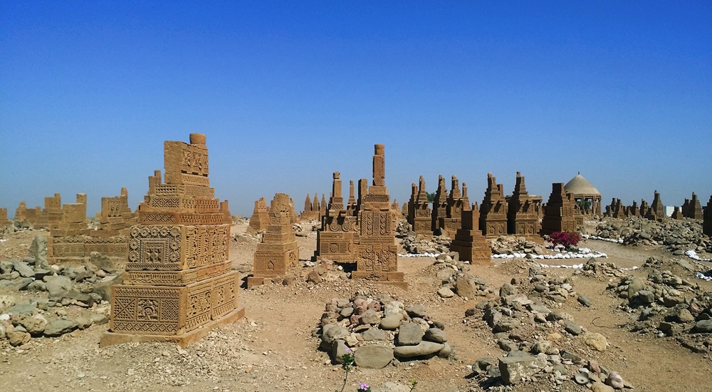
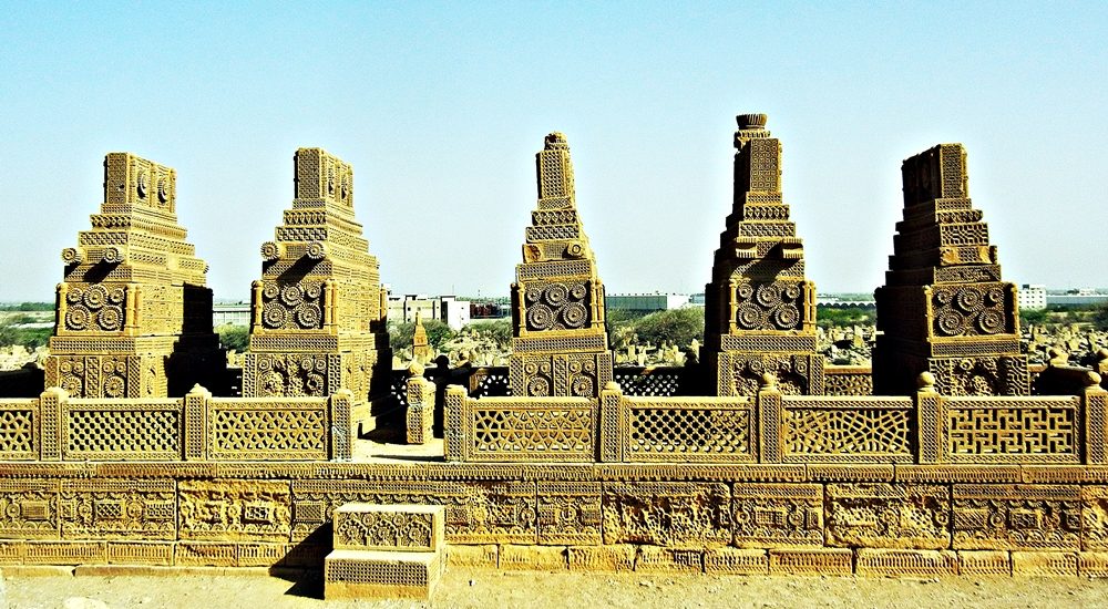
Expanding across a two-square-mile area, the Chaukandi Tombs near Karachi form an ancient Islamic burial site. The Chaukandi Tombs are renowned for its detailed sandstone carvings. These tombs bear a stylistic similarity to the elaborate graves located at the Makli Necropolis, one of the six UNESCO World Heritage Sites, near Thatta. Displaying the distinctive funerary architectural style typical of lower Sindh, the Chaukhandi Tombs undoubtedly provide a fascinating insight into the historical and artistic legacy of the region. History of Chaukandi Tombs: The Chaukhandi graveyard is attributed to the Jokhio tribe of Sindh. At the same time, other Sindhi tribes like Burfat, Jakhra, and Shaikh tombs are also found. The graveyard was constructed during the Mughal rule from the 15th to the 18th century, a period dominated by Islam. In addition to the Jokhio tribe, various Baloch tribes with Rajput origins have found their final resting place here. The influence of the Rajput tribe is evident in the design of the tombs. The step-shaped graves basically showcase a blend of cultures. For instance, some graves feature Rajput characteristics like monumental pedestals and slabs, while others exhibit simpler decorations, resembling a child’s drawing of a human face. Likewise, some tombs lack any human figures, reflecting Islamic beliefs and contributing to the diverse historical tapestry preserved in the Chaukhandi necropolis. The majority of the tombs at Chaukhandi especially represent family graveyards. However, only a limited number placed beneath pillar canopies that exhibit a Hindu architectural style. On certain male graves, intricate carvings depict a horseman equipped with arms such as a shield, sword, bow, and arrow. Meanwhile, carvings on women’s graves portray ornamental details like bracelets, necklaces, rings, anklets, and more. Additionally, for male graves, a boss-shaped projection at the northern end is designed to secure the turban of the deceased. These detailed carvings provide insights into the cultural and personal attributes of the individuals interred at Chaukhandi. Design of Chaukandi Tombs: The tombs at Chaukhandi stand out as a distinctive illustration of surface burials. Unusually aligned from south to north, a departure from the norm in both the region and period, these tombs are crafted from substantial sandstone slabs intricately arranged to form refined pyramid shapes. The meticulous carving on these slabs showcases intricate patterns, drawings, and scenes that contribute to the unique artistic and historical significance of the Chaukhandi Tombs. The absence of precise dating inscriptions on the Chaukhandi Tombs makes it challenging to determine their exact historical timelines. A typical casket consists of six vertical slabs, with two placed at the head and foot of the grave and the remaining four covering the sides, accommodating the length of the body. The tomb takes on a pyramid-like shape, featuring six large slabs covered by another tomb comprising six smaller vertical slabs. The architecture of Chaukandi Tombs: These tombs explicitly represent a unique blend of Sindhi and Balochi architectural styles. Crafted from beige-colored sandstone, these tombs come in the form of single graves or clusters, containing up to eight tombs. Despite the challenges posed by the region’s arid climate, these tombs have endured, serving as a resilient testament to the culture and heritage of the area. Chaukhandi Tombs, a form of funerary architecture, are characterized by square-shaped structures. Its five horizontal slabs enclosing the upper part of the tomb. Notably, these structures often exhibit a carved knob resembling a crown or turban at the front. Graves of warriors from the tribe boast intricate designs and motifs, including depictions of horsemen, jewelry, and hunting scenes. In contrast, tombs of women showcase carvings of anklets, bracelets, and jewelry at the front rather than human figures. Men’s graves typically feature carvings of swords, symbolizing their role as protectors of the tribe during times of war. Distinctive Features of Chaukandi Tombs: The Chaukhandi Tombs exhibit several distinctive features: The most prominent visual characteristic of Chaukhandi tombs is their cone-shaped roofs, constructed using bricks or stones and mortar. This design choice was made to distribute the weight of the structure over a larger area, enhancing stability and durability. The walls of Chaukhandi tombs are built in a beehive formation. The tombs feature multiple layers of stones arranged in a stepped pyramid shape. Constructed from local stones and bricks, these walls often bear decorative designs. Inside each tomb, there is typically a dedicated prayer chamber. This space actually serves for mourning and remembrance of the departed. Accompanying every tomb is a raised grave platform, situated above the surrounding landscape. This platform serves as a place for the family of the deceased to conduct rituals related to the burial. Discovery of Chaukandi Tombs: The Chaukhandi Tombs gained historical recognition with the earliest reference found in a letter written by J. Macleod, a Scottish historian, to Sir Henry Bartle Edward Frere, a British administrator, in 1851. However, it was H. D. Baskerville, the Assistant Collector of Thatta in Karachi in 1917, who brought these historical graves into prominence. In 1922, the site was officially included in the Ancient Monuments Preservation Act. Jean Philippe Vogel, a distinguished Dutch epigraphist employed by the Archaeological Survey of India from 1901 to 1914, played a crucial role in shedding light on the tombs. His extensive research revealed that many of these tombs belonged to Muslims. It was evident from the Arab script inscribed on their graves. Vogel’s findings provided valuable historical insights into the religious heritage of India. Post-independence, scholars and historians continued their in-depth investigations into the Chaukhandi Tombs. Rubbings of these tombs were displayed globally, capturing the attention of academics and sparking further research into this significant archaeological site. Recommendations: Chaukhandi Tombs are highly recommended to visit for individuals passionate about archaeology and history. The site holds a wealth of historical narratives. If you’re intrigued, plan your visit to this amazing site. Apart from the rich decoration adorning the tombs, another noteworthy aspect shared with similar necropolises worldwide is the prevalent local belief that the area is haunted. The Chaukhandi Tombs are reputed to be one of the most haunted sites in the
Kot Diji Fort
Forts, Islamic Heritage, Monuments, Sindh

Kot Diji Fort

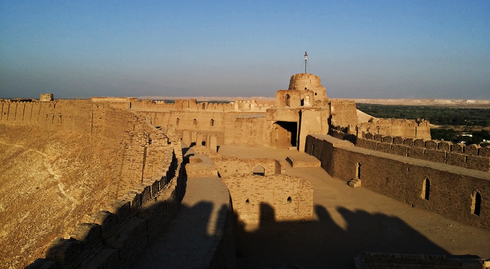
The Khairpur district in the Sindh province is renowned for housing several remarkable monuments showcasing architectural marvels, and one of them is the Kot Diji Fort from the Talpur Era. This historical edifice’s structure remains standing, preserving its grandeur for visitors to admire. The name “Kot Diji Fort” is derived from the Sindhi language phrase “Diji jo Qilo,” which translates to “Fort of the Daughter.” History of Kot Diji Fort The history of Kot Diji Fort reveals its significance during the Talpur Era in the Khairpur district of Sindh. The fort was divided into three parts among the Talpurs, with each portion falling under the control of different Talpur rulers. Mir Sohrab Khan was the first Talpur ruler of Khairpur Mirs and founder of the Kingdom of Upper Sindh. He played a crucial role in fortifying the frontiers of his rule. Among the forts he commissioned, Kot Diji Fort stands out as an architectural marvel. Mir Sohrab Khan constructed Kot Diji Fort in the capital town of Kotdiji, making it his residence a few years before his death. The fort was eventually handed over to his sons. Notably, in January 1843, during the military campaign led by Charles Napier to conquer Imam Garh, British troops also stayed at Kot Diji Fort. What adds to the historical significance of Kot Diji Fort is its location on the archaeological site of the pre-Harappan civilization, dating back to 2500-3000 BC. This unique aspect, combined with its association with Mir Sohrab Khan and the British military presence, makes Kot Diji Fort a prominent tourist attraction in Sindh. The fort stands as a testament to the rich historical and archaeological heritage of the region. Construction The construction of the remarkable historical monument in Sindh, Kot Diji Fort, spanned a decade, taking place from 1785 to 1795. Initially named “Fort Ahmadabad,” the fort derived its name from Ahmad, a Persian architect. He was credited with designing and engineering its praiseworthy architecture. Strategically located on an elevated landform, the fort was purposefully designed for warfare, enabling a vantage point to monitor potential threats. The fort is enclosed by a 30-foot tall wall, encompassing the uppermost section and resulting in a narrow-width fortress with a perimeter spanning 1.8 kilometers. Three towers, each standing at a height of 50 feet, grace the fort, contributing to its imposing structure. Kot Diji Fort includes various features such as cannon placements, water reservoirs, prisons, courtrooms, ammunition storage, and a small regal residence. The combination of architectural elements and strategic positioning highlights the fort’s historical significance and its role in safeguarding the region during its era of construction. Architecture The Kot Diji Fort is situated on a limestone hill at an elevation of 110 feet. It boasts a construction using kiln-baked bricks. Positioned on the southern end of Rohri Hills, the fort’s choice of bricks, rather than limestone rocks, was likely due to their local availability and the belief that limestone would easily shatter upon impact with cannonballs during a potential attack. Built during a time when cannons were prevalent, the fort’s design incorporates several stations for cannons. Its elevated position on a narrow ridge posed a challenge for enemy cannons, requiring them to fire from a considerable distance with limited accuracy. This strategic advantage meant cannonballs could either hit the hill or overshoot the fort. It would potentially endanger the enemy forces on the other side. Main Entrance The fort’s main entrance is known as the “Shahi Darwaza” or Royal Gate. It stands 13 feet high and 10 feet wide, constructed with wood and reinforced with 234 heavy iron spikes. This engineering feat aimed to prevent any attempts to break open the gate using a heavy contingent of elephants. The gate is situated in the western corner of the northern wall and serves as the sole entrance to the fort. Additionally, three secret passages were incorporated for emergency use. Upon entering through the curved gate, visitors find themselves in a small courtyard guarded by two bastions. It is strategically positioned for fortification and defense. The fort features three towers and multiple designated areas for cannon placements. Specialized zones include roofless rooms called “Barood Khano,” intended for storing ammunition. Other notable features within the fort include heavy bastions, towers, an ammunition depot, a water reservoir, the Mirs’ harem, a prison, a court, and cells for guards and sepoys. Design The fort, designed exclusively for defense, has never faced an attack throughout its history. Its architecture emphasizes simplicity, making it a unique and captivating historical site in Sindh. Fifty strategically placed bastions, such as “Fateh Thul” (Victory Tower), were named to identify their location and purpose, featuring small and large cannons to monitor enemy movements. Rooms Specialized rooms within the fort served specific functions, such as food storage and a lamp godown. A sandstone-made “Pavilion” stands out as a fascinating feature, adorned with beautifully carved arches and platforms. This structure was historically used by the ruler for court sessions. Moreover, it was also used for issuing important orders on significant occasions, adding to the fort’s historical charm and significance. Current Status After the British invasion, the administrative offices of Kotdiji Fort were relocated to Khairpur. The decision certainly led to a gradual decline in the fort’s importance. Subsequently, the fort was repurposed into a central prison, housing notorious criminals from the area and neighboring states. In 1955, following the merger of Khairpur state with Pakistan, the last ruler, Mir Ali Murad Khan Talpur II, handed over the fort to the government. With the 18th Constitutional amendment, the fort came under the custody of the Government of Sindh. Despite its historical significance, portions of the fort are reportedly under the control of influential local families. The government of Pakistan has recognized Kot Diji Fort as a protected heritage site, emphasizing its cultural and historical value. The fort, located in Kot Diji in the Khairpur District of Sindh province, offers breathtaking views with its picturesque landscape and high boundary walls. The scenic beauty of the

Day excursions from Karachi
City Breaks, Sindh

Excursions from Karachi

Originally a coastal village inhabited by fishermen along the southern Arabian Sea, Karachi has evolved into Pakistan’s economic epicenter. Boasting both historical and modern allure, it stands as the country’s largest and most populous city. Karachi encompasses a vast spectrum—from its picturesque urban panorama and lively lifestyle to its somber historical events. The city of lights never ceases to amaze those embarking on exploration. Beyond the myriad tourist sites within the city, there lie captivating destinations to the north and west that make for convenient day trips. Here are some prime choices for excursions from Karachi. The Chaukhandi tombs Located approximately 30 kilometers from Karachi, the Chaukhandi Tombs constitute an early Islamic burial ground. Renowned for their intricate sandstone carvings, these tombs share a stylistic resemblance with the ornate tombs found at the Makli Necropolis near Thatta. Reflecting the funerary architectural style characteristic of lower Sindh, the Chaukhandi Tombs offer a captivating glimpse into the historical and artistic heritage of the region. The ruins of Banbhore or Bhambore Banbhore, a prehistoric port city and archaeological site situated approximately 65 kilometers east of Karachi along Gharo Creek’s north bank, reveals a historical narrative spanning from the 1st century BC to the 13th century AD. Occupied by the Scytho-Parthians from the 1st century BC to the 2nd century AD, it then transitioned into the Hindu-Buddhist era from the 2nd to the 8th century AD. The Muslim period, lasting from the 8th to the 13th century, saw Banbhore abandoned due to a change in the course of the River Indus. Presently, Banbhore is a mound hosting remnants of an ancient city, featuring notable structures such as the earliest known mosque from 727 AD, a deep well, and others. Arab General Muhammad Bin Qasim made his historic entry into the Indian subcontinent through Banbhore in 712 AD, and the site has yielded distinctive artifacts, some displayed at the Banbhore Museum. Makli Necropolis Situated approximately 98 kilometers east of Karachi, in the Thatta district, Makli is a massive Muslim necropolis boasting a rich blend of historical monuments. It ranks among the world’s largest graveyards, covering an expansive area of 10 square kilometers. This burial ground bears witness to the splendid Sindhi culture spanning the 14th to the 18th centuries, with over half a million monuments scattered throughout its expanse. Laid out in a diamond-shaped layout, Makli is the final resting place for individuals from diverse backgrounds, including kings and queens, scholars and soldiers, philosophers, governors, saints, and commoners. The site features tombs, graves, and mausoleums, forming a captivating panorama of the varied lives that once contributed to the region’s cultural richness. Recognized for its historical significance, Makli was designated as a UNESCO World Heritage Site in 1981. Haleji Lake Located 91 kilometers from Karachi in the Thatta district of Sindh, Haleji Lake offers an engaging day trip, allowing visitors to explore not only the lake itself but also other attractions in Thatta city. Recognized as Asia’s largest bird sanctuary, the lake serves as a winter haven for thousands of migratory birds from Siberia. Hosting a diverse avian population, Haleji Lake is home to 223 bird species, encompassing coots, ducks, purple moorhens, kingfishers, pigeons, white herons, teals, waders, mallards, pelicans, cormorants, egrets, black-headed-gulls, pheasants, partridges, and storks. The lake is a paradise for bird watchers, with waterfowl being a highlight. In addition to the rich birdlife, Haleji Lake also boasts other species, including the presence of marsh crocodiles. Keenjhar Lake Keenjhar Lake, located 122 kilometers from Karachi and 22 kilometers from Thatta, is Pakistan’s second-largest freshwater lake, built in the 12th century as a water reservoir for Thatta. The azure waters and vibrant natural surroundings make it a vital wildlife sanctuary, hosting diverse bird species like ducks, geese, flamingos, and herons, while also serving as a breeding ground for notable birds. Beyond its ecological importance, the lake is culturally significant, linked to the Sindhi folklore of Noori-Jam Tamachi, where the raised tomb at the center is believed to be that of Noori, the Fisher girl, who married Jam Tamachi, the ruler of Sindh. Shah Jahan Mosque or Jamia Masjid Thatta Commissioned by Mughal King Shah Jahan (1644-47) as a gesture of gratitude to the people of Thatta, the Shah Jahan Mosque, also known as Jamia Masjid Thatta, stands as an enduring architectural marvel. Built with red brick and adorned with blue glazed tiles, it deviates from traditional Mughal design by lacking frescoes and featuring a distinctive roof with 93 domes instead of minarets. The architectural style combines Sindhi, Persian, Timurid, and Indian influences. The mosque boasts an interesting acoustic phenomenon, with the voice of the Mehrab resonating effortlessly throughout. The absence of additional acoustic aids is notable. The veranda ceilings are engineered for optimal airflow, ensuring a cool environment. Despite undergoing repairs, the mosque retains its historical and architectural significance, earning a spot on the UNESCO World Heritage List in 1993. Manora Island Manora is a compact island spanning 2.5 square kilometers, renowned as a popular picnic destination perfect for a day trip from Karachi. Accessible through a brief 30-minute ferry ride from Keamari Harbour, the gateway to Karachi’s bustling port, the island offers a distinctive experience with its expansive sandy beaches along the southern perimeter and refreshing sea breezes. Historically, Manora has significance as the site where the Talpur rulers surrendered to the British, leading to the construction of a still-standing lighthouse. Notably, it is believed that Alexander the Great camped on the island after his Indus Valley campaign on his journey to Babylonia. Manora continues to attract visitors seeking a tranquil escape and a glimpse into its rich history. Visitors often bring their own provisions and revel in a day away from the city’s hustle and bustle. Churna Island Churna Island stands as an optimal destination for water enthusiasts, offering a variety of water sports such as scuba diving, jet-skiing, banana boating, wake tubing, cliff jumping, snorkeling, and other aquatic activities. Positioned as a small rock reef in the Arabian Sea, it is enveloped by

Sindh Province
Blogs, Sindh

Sindh Province of Pakistan

Discover Sindh:  The Jewel of Southern Pakistan Sindh, the third-largest province of Pakistan, boasts Karachi as its bustling capital. Locally called “Mehran,” Sindh spans 54,407 square miles (140,914 square kilometers) and is home to over 47.8 million people (as per the 2017 census). Known for its rich cultural heritage and urbanized population (52.02%), Sindh offers a unique blend of history, tradition, and modernity. Geography of Sindh Situated in southeastern Pakistan, Sindh forms the lower Indus Basin. The landscape is predominantly flat, with the Kirthar Range marking its western boundary with Balochistan. To the northeast lies Punjab, while the east borders the Indian states of Rajasthan and Gujarat. The Arabian Sea graces its southern edge, adding scenic coastal beauty. Major Cities in Sindh Sindh comprises 29 districts, with Karachi hosting five of them. Key cities include: Karachi: The cosmopolitan hub and gateway to Sindh. Hyderabad: Renowned for its cultural richness and historical landmarks. Sukkur: Famous for its iconic bridges and river views. Thatta: Known for ancient sites and the Makli Necropolis. A Rich Historical Blend The name “Sindh” originates from the Sanskrit word “Sindhu,” meaning ocean or river, specifically referring to the Indus River. Over millennia, the region evolved through numerous civilizations and empires: Early Settlements: Dating back to 7000 BCE, with Mehrgarh expanding into Sindh and giving rise to the Indus Valley Civilization (3000–1500 BCE). Empires and Conquests: Conquered by the Persian Achaemenid Empire, Alexander the Great, and subsequently the Mauryan Empire. Islamic Era: In 711 AD, Muhammad bin Qasim introduced Islam to Sindh, earning it the title “Bab-ul-Islam” (Gateway to Islam). Dynastic Rule: Sindh saw seven ruling dynasties, including the Mughals and Talpurs, before becoming part of British India in the 19th century. Cultural Heritage of Sindh Sindh’s vibrant culture is reflected in its arts, crafts, and traditions: Clothing: Colorful attire is a hallmark. Women wear tie-dyed shawls and saris, while men don embroidered Sindhi caps and traditional lungis. Religious Influence: Sufi shrines play a central role, with devotional music and ceremonies forming a key part of rural life. Arts and Crafts: The region boasts 5,000 years of craftsmanship, including Ajrak (block-printed fabric), pottery, woodwork, and hand-woven textiles. Languages in Sindh Sindhi is the primary language, though regional dialects like Kutchi, Lari, and Saraiki are also prevalent. Karachi, a melting pot of cultures, is multilingual, with Urdu and English serving as key languages. Tourist Attractions in Sindh Sindh is a treasure trove of historical, architectural, and natural wonders, including: Mohenjo-Daro: A UNESCO World Heritage Site showcasing the Indus Valley Civilization. Ranikot Fort: Known as the Great Wall of Sindh. Shah Jahan Mosque: A masterpiece of Mughal architecture in Thatta. Makli Necropolis: One of the largest graveyards in the world. Keenjhar Lake: A serene escape for nature lovers. Karachi’s Landmarks: Quaid-e-Azam’s Mausoleum, Clifton Beach, and colonial-era buildings. Sindh’s Economy Sindh’s economy thrives on agriculture, with cotton, rice, wheat, and sugarcane as major crops. It is also famous for producing dates, mangoes, and bananas. Handicrafts, pottery, and textiles contribute to its economic landscape, continuing a legacy from the Indus Valley Civilization. Climate and Best Time to Visit Sindh experiences a tropical climate: Summers: Hot and dry (30–50°C). Winters: Mild and pleasant (10–30°C). The ideal time to visit is between November and March when the weather is more comfortable for exploring. Things to Do in Sindh Explore ancient ruins at Mohenjo-Daro. Visit Sufi shrines and experience local spirituality. Take a boat ride on Keenjhar or Haleji Lake. Discover architectural gems like Kot Diji Fort and Noor Mahal. Enjoy the vibrant city life of Karachi. Getting to Sindh Sindh is accessible via air, road, and rail: Air Travel: Jinnah International Airport (Karachi) connects to international and domestic destinations. Road and Rail: Well-connected highways and train services link Sindh to other major cities in Pakistan. Sindh’s diverse history, vibrant culture, and breathtaking landscapes make it a must-visit destination for history buffs, nature lovers, and cultural enthusiasts alike. Plan your trip to this enchanting province and experience the wonders of southern Pakistan! You may also want to read: Gilgit-Baltistan Islamabad Capital City Azad Jammu & Kashmir Khyber Pakhtunkhwa Punjab Balochistan

Tourist attractions in Karachi
City Breaks, Sindh

Karachi Tourist Attractions

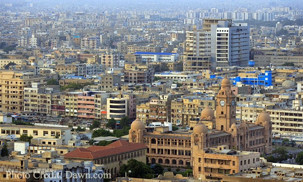
Karachi, known as the “City of Lights,” stands as the largest city on the Arabian coast, serving as a prominent industrial and marine port in Pakistan. The city’s plethora of tourist attractions reflects its vastness, offering a wide array of activities for visitors. Karachi’s major tourist highlights encompass cultural, architectural, and archaeological heritage, alongside an abundance of top-notch food outlets, entertainment centers, and numerous educational institutions. The city’s diverse offerings make it a compelling destination for a varied and enriching travel experience. Major AttractionsQuaid-i-Azam’s Mausoleum (Mazar-e-Quaid) Quaid e Azam mausoleum Perched gracefully atop a 54 square meters platform, providing a commanding view, the Quaid-e-Azam’s Mausoleum stands at the heart of Karachi and serves as the final resting place for Muhammad Ali Jinnah, the father of the nation and founder of Pakistan. Reflecting a fusion of traditional and modern Islamic architecture, the mausoleum draws inspiration from the Samanid Mausoleum in Uzbekistan. Within its walls, the mausoleum accommodates the graves of Mohtarma Fatima Jinnah, sister of Muhammad Ali Jinnah, and Pakistan’s first Prime Minister, Liaquat Ali Khan, in its basement. This monumental structure, built by Pakistani architect Yahya Merchant from 1958 to 1968, features an exterior adorned with white marble and an interior embellished with a four-tiered Chinese crystal chandelier, complemented by an Iranian silver railing. This architectural marvel not only commemorates a significant historical figure but also stands as a testament to the artistic blend of cultures and influences. Wazir Mansion The Wazir Mansion holds historical significance as the birthplace of Pakistan’s founder, Quaid-e-Azam Muhammad Ali Jinnah. This protected national monument, a three-story building located in Kharadar, Karachi, draws thousands of devoted Pakistanis who come to pay homage to their founding leader. Presently, the ground floor of the mansion serves as a museum, offering a glimpse into the life and times of Jinnah, while the upper floors showcase his personal belongings. Following partition, the house was acquired by a landlord who later named it Wazir Mansion. In the 1970s, the government of Pakistan purchased the property and designated it as a heritage site. The Wazir Mansion stands as a cherished landmark, preserving the historical legacy of Pakistan’s founder for generations to come. Mohatta Palace Constructed in 1925 by Marwari businessman Shivratan Chandraratan Mohatta, the Mohatta Palace served as his summer residence, spanning an area of approximately 18,500 square feet. Demonstrating distinctive features of Rajasthani architecture, the palace was crafted using pink Jodhpur stone and local yellow stone from Gizri. The terrace of the Palace was dedicated to the Hindu God, Lord Shiva. Mohatta could enjoy the palace only until the partition, after which he left for India. Post Pakistan’s independence, the palace was subsequently occupied by two sisters of Quaid-e-Azam Muhammad Ali Jinnah, Fatima Jinnah, and Shireen Jinnah, until 1980. Following Shireen Jinnah’s passing, the palace transformed into a museum. Presently, the Mohatta Palace serves as an art gallery and museum, with the premises utilized for hosting exhibitions. The rich history and architectural elegance of the palace make it a notable cultural and artistic venue in Karachi. Frere Hall Built in 1865, Frere Hall stands as a testament to the era of British rule in the subcontinent, exuding architectural charm and surrounded by verdant gardens. The well-preserved structure, designed by Henry Saint Clair Wilkins, now serves as a library and art gallery. Nestled in the Saddar district, known for its picturesque colonial architecture, the hall was erected in honor of Sir Henry Bartle Edward Frere, the commissioner of Sind (1851-1859), who played a pivotal role in promoting economic development in Karachi. Constructed with Karachi limestone, the yellowish tower comprises two floors housing a hall, an orchestral gallery, and the Liaquat Municipal Library on the ground floor. Sindh High Court Erected between 1923 and 1929, the Sindh High Court building in Saddar stands as an iconic colonial structure, showcasing exquisite Renaissance architecture. Constructed with the reddish-tinged Jodhpur sandstone, the building is adorned with cupolas, balconies, and towering Roman-style columns. The inauguration ceremony was officiated by His Excellency Sir Frederick Hugh Sykes, the Governor of Bombay. This architectural gem, crafted with meticulous detail, is among the few well-preserved heritage buildings in Karachi. Visitors are welcome to explore the Sindh High Court from 8:30 AM to 5:00 PM, Monday to Saturday, without the need for tickets or special permission. Karachi Metropolitan Development Corporation Building (KMC) Situated on M. A. Jinnah Road, the Karachi Metropolitan Corporation (KMC) is a historic building with a foundation stone laid in 1927, construction completed in 1930, and inauguration in 1932. Karachi boasts numerous architecturally captivating structures from the British Raj era, many of which now house public offices, making them less accessible for sightseeing. Among these remarkable buildings is the Karachi Metropolitan Development Corporation Building, constructed in 1935 to commemorate George V‘s Silver Jubilee. Characterized by pointed Oriental cupolas at its four corners, the building features a prominent clock tower also domed in the same distinctive style. Three Swords Monument (Teen Talwar) Commonly known as Teen Talwar, Three Swords stands as one of the oldest monuments in Clifton, Karachi. Commissioned by Pakistan’s former President and Prime Minister, Zulfikar Ali Bhutto, and constructed by the renowned Pakistani architect Mr. Mistri in the early 1970s, the swords symbolize Jinnah’s principles of Unity, Faith, and Discipline. Originally erected on Clifton Road in Karachi, it quickly became a prominent landmark. Hindu Gymkhana (National Academy of Performing Arts)  Located on Sarwar Shaheed Road in Sadar, Karachi, the Hindu Gymkhana serves as a significant tourist attraction. Established in 1925 during the colonial era, this building was originally conceived as a club for the Hindu elite class, occupying a leased area of approximately 47,000 square yards with a lease set to expire in 2020. In 1984, the Gymkhana faced imminent demolition due to its deteriorating condition but was fortunately preserved by the Heritage Foundation of Pakistan. The architectural style of the Hindu Gymkhana is a fusion of both Mughal and Hindu influences. Notably, within its premises, the Gymkhana houses the National Academy of Performing Arts—an

Makli Necropolis
City Breaks, Heritage Sites in Pakistan, Monuments, Sindh, Tombs, World Heritage Sites

Makli Necropolis

Unveiling the Enigma: Makli Necropolis – A Treasure Trove of History and Artistry Nestled in a diamond-shaped expanse, the grandeur of the Makli Necropolis in Thatta is unparalleled. It boasts of its status as one of the largest graveyards globally covering a sprawling 10 square kilometers. Altogether, the Makli Necropolis houses an astonishing half-million monuments. The graveyard stands as the final resting place for an eclectic mix of individuals, from regal monarchs and erudite scholars to valiant warriors, philosophers, governors, and revered saints. In recognition of its historical significance, Makli Necropolis, therefore, earned its place among the UNESCO World Heritage Sites of Pakistan in 1981. A Journey Through Time: Unraveling the History of Makli Necropolis Delving into the annals of history, Makli Necropolis emerges as the eternal abode for over 125,000 saints. Throughout the ages, this city has undeniably been a beacon of knowledge housing around 400 educational institutions. Here students from the Muslim world and Asia came to hone their skills. Students generally engaged in a diverse array of subjects encompassing religion, politics, and philosophy.  Yet, the enigmatic origins of Makli remain shrouded in mystery. It is widely believed that the cemetery evolved around the shrine of the 14th-century Sufi Hamad Jamali. As for the etymology of “Makli,” two intriguing notions persist. Locals suggest that it signifies “Mecca-like,” while another legend ties it to the pious woman known as “Mai Makli.” Legend has it that her fervent prayers thwarted Sultan Firuz Shah Tughlaq’s conquest of Thatta until her passing. She now rests in Makli near the tomb of Jam Nizamuddin. Thatta enjoyed a glorious stint as the capital of Sindh from the 14th to the 18th centuries. Initially, it was ruled by three successive dynasties – Samma, Argun, and Tarkhan. However, it later came under the dominion of the Mughal emperors of Delhi from 1592 to 1739 before being ceded to Shah Nadir of Iran, marking the beginning of a period marked by decline and neglect. The Architectural Marvels of Makli Necropolis The monuments of Makli Necropolis are a testament to the social and political history of Sindh from the 14th to the 18th centuries. Crafted with exquisite architectural finesse, these tombs and graves epitomize the artistic prowess of their time. The tombs were built by utilizing an array of materials such as sand bricks, stone, and marble. Some of these monuments are opulently adorned with glazed tiles, boasting intricate designs, arched domes, and towers adorned with exquisite Islamic calligraphy and devotional carvings inspired by diverse religious and iconographic traditions. Remarkably, many of these iconic monuments have withstood the test of time, enduring centuries of exposure to the elements. However, preserving this rich heritage for future generations necessitates substantial restoration efforts. Makli Necropolis: A Journey Through Location and Access Situated adjacent to the tip of the Indus River delta, Makli Necropolis lies on the outskirts of Thatta.  It was an ancient bastion of Islamic civilization nestled at the edge of the 6.5-kilometer-long plateau of Makli. This historic site is located approximately 89 kilometers east of Karachi in the Sindh province of southern Pakistan. Makli offers an ideal day trip from the bustling metropolis of Karachi. Navigating the vast expanse of the graveyard is made convenient through its wide streets, ensuring access to all the awe-inspiring monuments. Makli Necropolis undoubtedly stands as a testament to the rich tapestry of history, culture, and artistry. The graveyard has woven itself into the very fabric of this remarkable site. It beckons not only to history enthusiasts but also to travelers, both domestic and international, and devout pilgrims alike, offering a glimpse into an enigmatic past that continues to captivate our imaginations.

Mohenjo-daro UNESCO World Heritage Site in Sindh
Archaeological sites, Sindh, World Heritage Sites

Mohenjo-Daro

Unlocking the Enigma of Mohenjo-Daro: A Dive into Ancient History Mohenjo-Daro also spelled as Mohenjodaro or Moenjodaro, holds a mystique as intriguing as its name, which translates to “Mound of the Dead.” This archaeological gem is nestled in the Sindh province of Pakistan, offering a window into the enigmatic Indus Valley Civilization (IVC) that thrived around 2600 BC. Mohenjo-Daro is one of the six UNESCO World Heritage Sites in Pakistan inscribed in 1980. The city’s original name remains a mystery. The Dawn of Civilization Our story begins around 5500 B.C. when a nomadic tribe settled in the villages west of the lower Indus River. These early settlers, adapting to their environment, mastered tools, constructed humble dwellings, cultivated crops, and tamed animals. Over centuries, as climate patterns evolved, lush jungles and thriving wildlife emerged. Gradually, this nascent community expanded both in size and influence, engaging in trade with regions as distant as Central Asia and the neighboring western territories. By 2600 BC, Mohenjo-Daro evolved into a civilization rivaling the sophistication of Mesopotamia and Egypt. Unveiling the Indus Valley Civilization The Indus Valley Civilization, also known as the Harappan Civilization, boasted two major cities, Harappa and Mohenjo-Daro, along with over 100 smaller settlements. It marked the dawn of urbanization in the Indian subcontinent. From 2600 B.C. to 1700 B.C., this civilization thrived on the fertile plains along the Indus River, showcasing remarkable literacy with a unique script consisting of 250-500 Dravidian characters. This civilization stands tall among the world’s great ancient cultures, with its initial discovery at Harappa in 1921, followed by Mohenjo-Daro in 1922. Rediscovery and Archaeological Endeavors The journey to resurrect Mohenjo-Daro’s glory began in 1922 when R.D. Banerji, an archaeologist with the Archaeological Survey of India, stumbled upon the site. A series of extensive excavations, overseen by renowned archaeologists, occurred until the 1930s. Later, in 1964-65, brief excavations resumed, only to be halted due to preservation challenges. Mohenjo-Daro’s sprawling ruins, stretching across approximately 750 acres, housed a peak population of around 40,000, making it one of the world’s largest and most advanced cities in its era. The city’s construction, characterized by unbaked bricks atop elevated mounds, exemplifies meticulous town planning principles. Urban Planning and Infrastructure Mohenjo-Daro’s urban layout followed a structured grid, with rectilinear buildings dominating the landscape. Most structures were constructed using standardized fired and mortared bricks, complemented by evidence of sun-dried bricks and wooden superstructures. The city comprised two main sections: the Citadel, standing 12 meters high and featuring two grand assembly halls and public baths, likely reserved for religious ceremonies, and the Lower City, comprising courtyard houses for the middle class. These houses featured brick stairs leading to flat roofs and small bathrooms equipped with drains and sanitation facilities. The Magnificent Great Bath A crowning jewel among Mohenjo-Daro’s structures is the Great Bath, astonishingly well-preserved after millennia. Measuring 180 feet by 108 feet, this structure features outer walls that are 7 to 8 feet thick, and lined with bitumen. This remarkable pool may have played a role in religious purification, with dimensions of 39 feet in length, 23 feet in width, and 8 feet in depth. Masterful Water Management Mohenjo-Daro boasted an intricate water management system, highlighted by a central marketplace well and smaller household wells. A sophisticated covered drainage system efficiently handled wastewater, while high-status residences included spacious homes with attached baths and integrated drainage. Many houses featured inner courtyards, their doors opening onto side-lanes. Achievements and Trade The people of Mohenjo-Daro exhibited advanced knowledge of weights, measures, and arithmetic with decimals. Their pottery showcased intricate geometric designs, and they crafted figurines reflecting their beliefs. Major crops included wheat, rice, mustard, dates, and cotton, while animals such as dogs, cats, camels, sheep, pigs, goats, water buffaloes, elephants, and chickens thrived. The presence of guard towers and defensive fortifications suggests that Mohenjo-Daro may have served as an administrative center. Archaeological evidence points to the city’s repeated destruction and reconstruction, with causes attributed to massive Indus River flooding or encroachment, mirroring a resilient spirit in the face of adversity. Unearthed Treasures Excavations at Mohenjo-Daro unearthed a treasure trove of antiquities. The findings include seated and standing sculptures, clay toys, pottery, stone axes, flake knives, coins, and copper and bronze artifacts. Among these, the iconic “Dancing Girl,” a 4,500-year-old bronze statue discovered in 1926, captures the imagination. Noteworthy discoveries also include the priest-king statue and a gold disc suggesting a third eye or “Bindi.” The Mysterious Decline Around 1700 B.C., a shadow fell over the Indus Valley Civilization, including Mohenjo-Daro. The precise cause of this decline remains shrouded in mystery. Theories range from shifts in the Indus River’s course to devastating floods or a decline in rainfall, leading to agricultural woes and eventual abandonment. Recent core drilling in 2015 revealed that Mohenjo-Daro’s true extent surpasses the excavated area. It is hinting at more secrets yet to be unveiled. Location and Accessibility For modern-day adventurers, the archaeological marvel of Mohenjo-Daro is situated approximately 510 km northeast of Karachi, 110 km southwest of Sukkur, and about 28 km from Larkana. Road access is available from Karachi, Bahawalpur, and Multan, making it a feasible day trip. Alternatively, Mohenjo-Daro boasts its airport, providing convenient access for travelers. Whether flying in from Karachi or taking a flight to Sukkur from major cities like Islamabad and Lahore, followed by a road journey to Moenjo-Daro, this ancient treasure is within reach, inviting you to step back in time. Intrigue and wonder continue to surround Mohenjo-Daro, beckoning explorers and historians alike to unlock the mysteries of this ancient marvel. This archaeological wonder serves as a testament to the ingenuity and resilience of a civilization lost to time. It is waiting to share its secrets with those who dare to delve into its history.

Scroll to Top