Monuments

Konodas Suspension Bridge
City Breaks, Gilgit-Baltistan, Monuments

Konodas Suspension Bridge

Konodas Suspension Bridge The Konodas Suspension Bridge is a must-visit attraction in the picturesque region of Gilgit-Baltistan, Pakistan. This historic structure connects the Old Gari Bagh Bazaar in Gilgit with the Konodas area, serving as a vital link for local communities while showcasing the rich heritage of the colonial era. A Glimpse into History Built during the rule of the Maharaja of Kashmir, before the region’s accession to Pakistan, the Konodas Suspension Bridge stands as a testament to the engineering prowess of its time. Constructed over a span of 10 years, from 1895 to 1905, this bridge has surpassed a century in age. Once the only connection between the then Gilgit Agency and Central Asia; the bridge played a crucial role in trade and communication in the region. Resilient Design The flawless design of the Konodas Suspension Bridge has enabled it to withstand numerous natural calamities over the years. Unlike other structures in Gilgit-Baltistan that have succumbed to floods and harsh weather conditions, this bridge remains intact, symbolizing durability and innovation. Scenic Splendor Nestled in the breathtaking landscape of Gilgit-Baltistan, the Konodas Suspension Bridge offers more than just historical significance. The surrounding scenery, characterized by the turquoise waters of the Gilgit River and the dramatic backdrop of rugged mountains, makes it a paradise for photographers and nature lovers. Visitors can enjoy stunning panoramic views while crossing the bridge, making it a popular spot for sightseeing and photography. Key Highlights Functional Purpose: The Konodas Suspension Bridge continues to serve as a vital route for pedestrians and light vehicles, connecting the Konodas area with other parts of Gilgit. Accessibility: The bridge’s proximity to Gilgit city center makes it easily accessible for tourists and locals alike. A short journey from the town brings visitors to this iconic landmark. Adventurous Experience: Walking across the swaying suspension bridge is an exhilarating experience, enhanced by the sound of rushing river waters below. Photographic Appeal: The natural beauty surrounding the bridge creates an ideal setting for capturing memorable photographs. Why Visit the Konodas Suspension Bridge? Blending historical significance with scenic beauty, the Konodas Suspension Bridge is a shining example of engineering adaptability in the mountainous terrain of northern Pakistan. Whether you’re a history enthusiast, a photography lover, or an adventurer, this bridge offers something for everyone. Plan your visit to the Konodas Suspension Bridge and immerse yourself in the timeless charm and breathtaking views of this remarkable landmark. It’s an experience that will leave you in awe of both nature’s grandeur and human ingenuity. Nearby Attractions: British Cemetery Gilgit Biddulph House & Library Karga Buddha Hanzel Stupa Agortham Boulder Uprising Memorial Gilgit Konodas Rock Carvings Danyore Suspension Bridge Danyore Rock Inscription Chinese Graveyard Danyore The Victory Monument of Taj Mughal

Ganish Historic Settlement
Gilgit-Baltistan, Monuments

Ganish Historic Settlement

Ganish Historic Settlement: A 1000-Year-Old Living History Nestled in the enchanting Hunza Valley, Ganish Historic Settlement is a rich blend of history, culture, and architecture. This small yet historically significant settlement, located along the iconic Karakoram Highway. It is believed to be the oldest village in Hunza. Ganish is recognized by UNESCO for its cultural heritage conservation. The valley offers a fascinating glimpse into the region’s storied past and vibrant traditions. A Living History on the Ancient Silk Route Ganish Historic Settlement, also known as Ganish Khun, is a 1000-year-old settlement that traces its origins to the ancient Silk Route. Its strategic location made it a critical outpost for travelers and traders journeying through the Northern Areas as early as 180 BCE to 10 CE. The village’s heritage is rooted in its original residents—the Yarikutz, Rupikutz, Kuyokutz, and Mamorokutz families—who constructed four historic mosques and watchtowers during the 16th and 17th centuries. Despite challenges like floods in 1960 and the construction of the Karakoram Highway in the 1970s, the village has retained much of its original layout, including 39 houses dating back to the 15th century. UNESCO-Awarded Conservation Efforts Ganish Village has received two UNESCO awards for Cultural Heritage Conservation in Asia Pacific (2002 and 2009). These accolades recognize the restoration efforts led by the local community with support from the Aga Khan Cultural Services Pakistan (AKCSP) and funding from nations like Norway and Spain. The preservation work not only brought Ganish international recognition but also inspired nearby communities to conserve their cultural heritage, creating a ripple effect across the region. What to See Entrance and Facilities The village’s entrance is marked by a modern Imam Bargah, which also houses a library, a dispensary, and facilities for traditional burial practices. Visitors are welcomed with a formalized entry process, including a Rs.500 fee. A local guide narrates captivating history of the village by leading you through to explore its charming streets and structures. Fortified Layout and Unique Architecture Ganish was initially built as a fortified settlement to guard against invasions. Compact houses with small doors and narrow streets reflect the practical design of the era. Homes often housed livestock near entrances to provide insulation during harsh winters and as an alert system against potential threats. The watchtowers, of which only a few remain, were strategically placed for surveillance. Originally, the back of the village overlooked a river, providing a natural defense. Although natural disasters have altered the landscape, the village’s architectural essence remains intact. Historic Mosques The four historic mosques are among Ganish’s most remarkable features. Built by local rulers to leave a lasting legacy, these mosques are small in size, reflecting the needs of the community at the time. The mosques’ wooden relief work showcases a blend of Buddhist lotus flowers, Hindu swastikas, Chinese cloud motifs, and Islamic geometric patterns, symbolizing the region’s multicultural history. Cultural and Symbolic Significance The name “Ganish” originates from Ghenish – a term in local Burushaski language referring to “gold” or “gold reserve,” highlighting the area’s historical importance. It also translates to “plain” or “plateau,” which aptly describes the settlement’s relatively flat terrain compared to the surrounding mountainous regions. The intricate carvings and motifs on the mosques’ arches underscore the village’s rich cultural interactions. These carvings offer ample opportunities for further research into the symbolism and artistry of this historic site. Why Visit Ganish Historic Settlement? Ganish Historic Settlement is more than a historic site—it’s a living heritage. Its well-preserved architecture, the stories of its people, and the blending of diverse cultural influences make it a must-visit destination for anyone exploring the Hunza Valley. The village stands as a testament to the resilience and creativity of its inhabitants, offering inspiration for cultural preservation and community-led initiatives. Next time you find yourself in the breathtaking Hunza Valley, make sure to add Ganish Historic Settlement to your itinerary. It’s a journey back in time that will leave you with a profound appreciation for the region’s history and heritage. Access to Ganish: From Gilgit, the capital city of Gilgit-Baltistan, Ganish is about 100km (2 hrs drive approximately) along the Karakoram Highway and is one of the key Karakoram Highway attractions. Nearest Attractions: Karimabad Bazaar Baltit Fort Altit Fort Duikar View Point Haldikish Attabad Lake Borith Lake Afsang View Point Ondra Poygah Passu Glacier Hoper Valley

Chaukandi Tombs
Heritage Sites in Pakistan, Islamic Heritage, Monuments, Sindh, Tombs, World Heritage Sites

Chaukandi Tombs

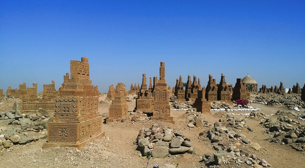
Expanding across a two-square-mile area, the Chaukandi Tombs near Karachi form an ancient Islamic burial site. The Chaukandi Tombs are renowned for its detailed sandstone carvings. These tombs bear a stylistic similarity to the elaborate graves located at the Makli Necropolis, one of the six UNESCO World Heritage Sites, near Thatta. Displaying the distinctive funerary architectural style typical of lower Sindh, the Chaukhandi Tombs undoubtedly provide a fascinating insight into the historical and artistic legacy of the region. History of Chaukandi Tombs: The Chaukhandi graveyard is attributed to the Jokhio tribe of Sindh. At the same time, other Sindhi tribes like Burfat, Jakhra, and Shaikh tombs are also found. The graveyard was constructed during the Mughal rule from the 15th to the 18th century, a period dominated by Islam. In addition to the Jokhio tribe, various Baloch tribes with Rajput origins have found their final resting place here. The influence of the Rajput tribe is evident in the design of the tombs. The step-shaped graves basically showcase a blend of cultures. For instance, some graves feature Rajput characteristics like monumental pedestals and slabs, while others exhibit simpler decorations, resembling a child’s drawing of a human face. Likewise, some tombs lack any human figures, reflecting Islamic beliefs and contributing to the diverse historical tapestry preserved in the Chaukhandi necropolis. The majority of the tombs at Chaukhandi especially represent family graveyards. However, only a limited number placed beneath pillar canopies that exhibit a Hindu architectural style. On certain male graves, intricate carvings depict a horseman equipped with arms such as a shield, sword, bow, and arrow. Meanwhile, carvings on women’s graves portray ornamental details like bracelets, necklaces, rings, anklets, and more. Additionally, for male graves, a boss-shaped projection at the northern end is designed to secure the turban of the deceased. These detailed carvings provide insights into the cultural and personal attributes of the individuals interred at Chaukhandi. Design of Chaukandi Tombs: The tombs at Chaukhandi stand out as a distinctive illustration of surface burials. Unusually aligned from south to north, a departure from the norm in both the region and period, these tombs are crafted from substantial sandstone slabs intricately arranged to form refined pyramid shapes. The meticulous carving on these slabs showcases intricate patterns, drawings, and scenes that contribute to the unique artistic and historical significance of the Chaukhandi Tombs. The absence of precise dating inscriptions on the Chaukhandi Tombs makes it challenging to determine their exact historical timelines. A typical casket consists of six vertical slabs, with two placed at the head and foot of the grave and the remaining four covering the sides, accommodating the length of the body. The tomb takes on a pyramid-like shape, featuring six large slabs covered by another tomb comprising six smaller vertical slabs. The architecture of Chaukandi Tombs: These tombs explicitly represent a unique blend of Sindhi and Balochi architectural styles. Crafted from beige-colored sandstone, these tombs come in the form of single graves or clusters, containing up to eight tombs. Despite the challenges posed by the region’s arid climate, these tombs have endured, serving as a resilient testament to the culture and heritage of the area. Chaukhandi Tombs, a form of funerary architecture, are characterized by square-shaped structures. Its five horizontal slabs enclosing the upper part of the tomb. Notably, these structures often exhibit a carved knob resembling a crown or turban at the front. Graves of warriors from the tribe boast intricate designs and motifs, including depictions of horsemen, jewelry, and hunting scenes. In contrast, tombs of women showcase carvings of anklets, bracelets, and jewelry at the front rather than human figures. Men’s graves typically feature carvings of swords, symbolizing their role as protectors of the tribe during times of war. Distinctive Features of Chaukandi Tombs: The Chaukhandi Tombs exhibit several distinctive features: The most prominent visual characteristic of Chaukhandi tombs is their cone-shaped roofs, constructed using bricks or stones and mortar. This design choice was made to distribute the weight of the structure over a larger area, enhancing stability and durability. The walls of Chaukhandi tombs are built in a beehive formation. The tombs feature multiple layers of stones arranged in a stepped pyramid shape. Constructed from local stones and bricks, these walls often bear decorative designs. Inside each tomb, there is typically a dedicated prayer chamber. This space actually serves for mourning and remembrance of the departed. Accompanying every tomb is a raised grave platform, situated above the surrounding landscape. This platform serves as a place for the family of the deceased to conduct rituals related to the burial. Discovery of Chaukandi Tombs: The Chaukhandi Tombs gained historical recognition with the earliest reference found in a letter written by J. Macleod, a Scottish historian, to Sir Henry Bartle Edward Frere, a British administrator, in 1851. However, it was H. D. Baskerville, the Assistant Collector of Thatta in Karachi in 1917, who brought these historical graves into prominence. In 1922, the site was officially included in the Ancient Monuments Preservation Act. Jean Philippe Vogel, a distinguished Dutch epigraphist employed by the Archaeological Survey of India from 1901 to 1914, played a crucial role in shedding light on the tombs. His extensive research revealed that many of these tombs belonged to Muslims. It was evident from the Arab script inscribed on their graves. Vogel’s findings provided valuable historical insights into the religious heritage of India. Post-independence, scholars and historians continued their in-depth investigations into the Chaukhandi Tombs. Rubbings of these tombs were displayed globally, capturing the attention of academics and sparking further research into this significant archaeological site. Recommendations: Chaukhandi Tombs are highly recommended to visit for individuals passionate about archaeology and history. The site holds a wealth of historical narratives. If you’re intrigued, plan your visit to this amazing site. Apart from the rich decoration adorning the tombs, another noteworthy aspect shared with similar necropolises worldwide is the prevalent local belief that the area is haunted. The Chaukhandi Tombs are reputed to be one of the most haunted sites in the

Kot Diji Fort
Forts, Islamic Heritage, Monuments, Sindh

Kot Diji Fort

The Khairpur district in the Sindh province is renowned for housing several remarkable monuments showcasing architectural marvels, and one of them is the Kot Diji Fort from the Talpur Era. This historical edifice’s structure remains standing, preserving its grandeur for visitors to admire. The name “Kot Diji Fort” is derived from the Sindhi language phrase “Diji jo Qilo,” which translates to “Fort of the Daughter.” History of Kot Diji Fort The history of Kot Diji Fort reveals its significance during the Talpur Era in the Khairpur district of Sindh. The fort was divided into three parts among the Talpurs, with each portion falling under the control of different Talpur rulers. Mir Sohrab Khan was the first Talpur ruler of Khairpur Mirs and founder of the Kingdom of Upper Sindh. He played a crucial role in fortifying the frontiers of his rule. Among the forts he commissioned, Kot Diji Fort stands out as an architectural marvel. Mir Sohrab Khan constructed Kot Diji Fort in the capital town of Kotdiji, making it his residence a few years before his death. The fort was eventually handed over to his sons. Notably, in January 1843, during the military campaign led by Charles Napier to conquer Imam Garh, British troops also stayed at Kot Diji Fort. What adds to the historical significance of Kot Diji Fort is its location on the archaeological site of the pre-Harappan civilization, dating back to 2500-3000 BC. This unique aspect, combined with its association with Mir Sohrab Khan and the British military presence, makes Kot Diji Fort a prominent tourist attraction in Sindh. The fort stands as a testament to the rich historical and archaeological heritage of the region. Construction The construction of the remarkable historical monument in Sindh, Kot Diji Fort, spanned a decade, taking place from 1785 to 1795. Initially named “Fort Ahmadabad,” the fort derived its name from Ahmad, a Persian architect. He was credited with designing and engineering its praiseworthy architecture. Strategically located on an elevated landform, the fort was purposefully designed for warfare, enabling a vantage point to monitor potential threats. The fort is enclosed by a 30-foot tall wall, encompassing the uppermost section and resulting in a narrow-width fortress with a perimeter spanning 1.8 kilometers. Three towers, each standing at a height of 50 feet, grace the fort, contributing to its imposing structure. Kot Diji Fort includes various features such as cannon placements, water reservoirs, prisons, courtrooms, ammunition storage, and a small regal residence. The combination of architectural elements and strategic positioning highlights the fort’s historical significance and its role in safeguarding the region during its era of construction. Architecture The Kot Diji Fort is situated on a limestone hill at an elevation of 110 feet. It boasts a construction using kiln-baked bricks. Positioned on the southern end of Rohri Hills, the fort’s choice of bricks, rather than limestone rocks, was likely due to their local availability and the belief that limestone would easily shatter upon impact with cannonballs during a potential attack. Built during a time when cannons were prevalent, the fort’s design incorporates several stations for cannons. Its elevated position on a narrow ridge posed a challenge for enemy cannons, requiring them to fire from a considerable distance with limited accuracy. This strategic advantage meant cannonballs could either hit the hill or overshoot the fort. It would potentially endanger the enemy forces on the other side. Main Entrance The fort’s main entrance is known as the “Shahi Darwaza” or Royal Gate. It stands 13 feet high and 10 feet wide, constructed with wood and reinforced with 234 heavy iron spikes. This engineering feat aimed to prevent any attempts to break open the gate using a heavy contingent of elephants. The gate is situated in the western corner of the northern wall and serves as the sole entrance to the fort. Additionally, three secret passages were incorporated for emergency use. Upon entering through the curved gate, visitors find themselves in a small courtyard guarded by two bastions. It is strategically positioned for fortification and defense. The fort features three towers and multiple designated areas for cannon placements. Specialized zones include roofless rooms called “Barood Khano,” intended for storing ammunition. Other notable features within the fort include heavy bastions, towers, an ammunition depot, a water reservoir, the Mirs’ harem, a prison, a court, and cells for guards and sepoys. Design The fort, designed exclusively for defense, has never faced an attack throughout its history. Its architecture emphasizes simplicity, making it a unique and captivating historical site in Sindh. Fifty strategically placed bastions, such as “Fateh Thul” (Victory Tower), were named to identify their location and purpose, featuring small and large cannons to monitor enemy movements. Rooms Specialized rooms within the fort served specific functions, such as food storage and a lamp godown. A sandstone-made “Pavilion” stands out as a fascinating feature, adorned with beautifully carved arches and platforms. This structure was historically used by the ruler for court sessions. Moreover, it was also used for issuing important orders on significant occasions, adding to the fort’s historical charm and significance. Current Status After the British invasion, the administrative offices of Kotdiji Fort were relocated to Khairpur. The decision certainly led to a gradual decline in the fort’s importance. Subsequently, the fort was repurposed into a central prison, housing notorious criminals from the area and neighboring states. In 1955, following the merger of Khairpur state with Pakistan, the last ruler, Mir Ali Murad Khan Talpur II, handed over the fort to the government. With the 18th Constitutional amendment, the fort came under the custody of the Government of Sindh. Despite its historical significance, portions of the fort are reportedly under the control of influential local families. The government of Pakistan has recognized Kot Diji Fort as a protected heritage site, emphasizing its cultural and historical value. The fort, located in Kot Diji in the Khairpur District of Sindh province, offers breathtaking views with its picturesque landscape and high boundary walls. The scenic beauty of the

Alexander Monument Pakistan
City Breaks, Monuments, Punjab

Alexander Monument

The Alexander Monument: A Historical Marvel in Pakistan The Alexander Monument is a facility located in Jalalpur Sharif covering an area of 60 square meters. It is believed that Alexander the Great camped for two months before the Battle of Hydaspes. The architecture reflects a blend of Greek influences, with 16 arches adorning the roof. Inside, a circular plaque displays a map marking Alexander’s journey from Pella, Greece, to Persia, and finally, to the site of the monument. The foundation stone for the Alexander monument was laid on 24 May 1997 by the Greek ambassador H.E. Mr. E. N. Karayannis, in collaboration with the government of Pakistan. Dr. Abdul Qadeer Khan, the famous Pakistani nuclear scientist, inaugurated this magnificent structure. The Battle of Hydaspes and Alexander’s Conquest Alexander the Great, a renowned conqueror, left an indelible mark as he swept through several empires, from Greece to the heart of Asia, reaching the land that is now known as Pakistan. One of his most memorable invasions was the famous Battle of Hydaspes in 326 BC, where he tactfully defeated Raja Porus of Pauravas on the banks of the Hydaspes River, now known as the Jehlum River. This pivotal encounter led to the annexation of the Indian ruler’s empire. The Battle of Hydaspes: Location and Armies The Battle of Hydaspes took place at Mong, opposite Jalalpur Sharif, on the right bank of the Hydaspes River. To confront Alexander, Porus gathered an army comprising 2000 cavalry, 200 elephants, and 30,000 soldiers. Alexander, on the other hand, crossed the river about 30km upstream from the battle site and launched a strategic attack. Alexander’s Loss and the Monument of Bucephalus During the war, Alexander mourned the loss of his beloved horse, Bucephalus. He buried the remains of his loyal steed near the modern-day town of Jalalpur Sharif. This region was later named Jalalpur Sharif, and a monument in honor of Alexander the Great was erected there. The town of Bucephala, named after Alexander’s horse, lies close to Jalalpur Sharif, and the ruins of an ancient city can still be found in the hills to the east of the town, with coins dating back to the period of Graeco-Bactrian kings. Discovering Jalalpur Sharif Originally known as Girjakh, Jalalpur Sharif was a thriving trade center in the region. Its name changed when Emperor Jalaluddin Muhammad Akbar, the third Mughal emperor, visited the town. To honor him, the ruler of the town, Malik Darwesh Khan Janjua, renamed it Jalalpur Sharif. The title “Sharif” is associated with the famous shrine of Pir Syed Ghulam Haider Ali Shah, one of the most renowned Chishti Spiritual Leaders of the Sub Continent. Unlocking the Past: Research and Significance The monument also serves as a research center, inviting both local and foreign scholars to delve into the mutual influence of Greek culture on Pakistan and vice versa. One of the primary research tasks is to identify the exact locations of two ancient cities: Nicaea, believed to be present-day Mong, and Bucephala, where Alexander built a monument in memory of his cherished horse. However, despite its historical significance, the Alexander Monument is in need of maintenance to regain its status as a prominent tourist attraction. Reaching Jalalpur Sharif: A Journey Through History For those seeking to visit the Alexander Monument in Jalalpur Sharif, the location is easily accessible. If you’re traveling from Islamabad, the 167km journey takes approximately 3 hours. The directions are as follows: Take Islamabad Expressway to Grand Trunk Rd/Islamabad – Lahore Rd/NH 5/AH2 in Rawat (30km). Follow Grand Trunk Rd/NH 5/AH2 to Islamabad – Lahore Rd/Pind Dadan Khan – Jhelum Rd/Tufail Rd in Jhelum Cantt, Jhelum (90km). Follow Pind Dadan Khan – Jhelum Rd to Bhoon Mkt Rd in Jalalpur Sharif (47km). Alternatively, you can take the 216km Lahore-Islamabad Motorway/AH1/M-2, which also takes approximately 4 hours from Islamabad. The directions are as follows: Get on Lahore-Islamabad Motorway/AH1/M-2 in Punjab from Srinagar Hwy (20km). Follow Lahore-Islamabad Motorway/AH1/M-2 to Choa Saidan Shah Road in Kallar Kahar. Exit from Lahore-Islamabad Motorway/AH1/M-2 (109km). Continue on Choa Saidan Shah Road. Take Chakwal Choa Saidan Shah Pindadan Khan Rd/Khewra Rd and Pind Dadan Khan – Jhelum Rd to Bhoon Mkt Rd in Jalalpur Sharif (87km). Plan Your Visit: Opening Hours and Fees The Alexander Monument in Jalalpur Sharif is open for visitors on weekdays (Monday to Saturday) from 10:00 am to 03:00 pm and on Sundays and holidays from 10:00 am to 05:00 pm.

Akbari Sarai from front
Monuments, Punjab

Akbari Sarai

Akbari Sarai: A Marvel of Mughal Architecture in Lahore, Pakistan The enigmatic Akbari Sarai, a treasure trove of Mughal heritage, lies in the heart of Lahore, Punjab, Pakistan. It is nestled gracefully between the magnificent Jahangir’s Tomb and the resplendent Asif Khan’s Tomb. This sprawling oblong-shaped courtyard dates back to 1637. The Sarai boasts a rich history as a haven for travelers and a sanctuary for the guardians of Jahangir’s Tomb. At the same time, it served as a vital postal station known as Dak Chowki. Unveiling the Historical Veil Emperor Shah Jahan’s esteemed court historian, Abdul Hamid Lahori, documented the original designation of this grand edifice as the “Jilu Khana-e-Rauza” (attached court of the tomb) in his magnum opus, “The Padshahnama.” The terminology”Akbari Sarai” emerged during the reign of Islam Shah Suri in the mid-1550s, intriguingly not during the illustrious reign of the Mughal Emperor Akbar. Architectural Marvels Unveiled Spread over a vast expanse of 12 acres, the Akbari Sarai spans an impressive 797 feet by 610 feet. It boasts a perimeter adorned with 180 cells, each featuring a front veranda and a shared passageway. The Sarai’s architectural opulence shines through the presence of four Burjes, each housing intricate chambers. These chambers present an elliptical hall at their forefront, complemented by a veranda and an octagonal chamber at the rear. Access to this architectural wonder is granted through two imposing entrances located to the north and south. These entrances bear the hallmark of Mughal craftsmanship, adorned with captivating frescoes and the exquisite Ghalib Kari. The latter refers to a network of stucco and plaster ribs gracefully applied to the curved surfaces of each archway. Notably, the architectural attributes of the Sarai, including its decorative elements, structural style, and the size of the bricks used in its construction, exhibit the quintessential Mughal aesthetics. Interestingly, the eastern entrance gateway to Jahangir’s tomb is distinguished by its large double-storied iwan. It is further linked with four smaller arched niches, hinting at a concurrent construction period. A Glimpse into the Past Towards the western periphery of the Sarai, amidst the line of cells, rests a mosque dating back to the Suri era. This mosque is characterized by three resplendent domes. Although time has eroded much of its artistic grandeur, the sandstone-facing facade adorned with inlay work still exudes an aura of grace. The cells that grace the complex, along with its ornate gateways, owe their existence to the Shah Jahan period during the mid-1600s. Administrative Marvels The Akbari Sarai, in its heyday, served as an esteemed state guesthouse, overseen by a Shahna (official caretaker) and a team of dedicated assistants. Moreover, the establishment even boasted a resident physician and a skilled baker. Travelers and guests were treated to a range of amenities, including complimentary fodder for their animals, access to both hot and cold water, and comfortable bedsteads. However, as history continued to unfold, the Sarai witnessed various transformations. During the Sikh era, for instance, Maharajah Ranjit Singh repurposed the complex. He converted it into a cantonment for one of his foreign generals, Musa Farangi. Subsequently, during the British colonial period, it took on a new role as a rail depot. Albeit, It suffered significant damage with the construction of a nearby rail line. A Shared UNESCO Dream The Akbari Sarai, along with its illustrious neighbors, Jahangir’s Tomb and the Tomb of Asif Khan, were jointly recognized in 1993 when they were included in the tentative list of UNESCO World Heritage Sites. This recognition underscores their significance as custodians of Mughal history and architectural prowess, captivating the world with their timeless charm. The Akbari Sarai stands as a testament to the glorious Mughal era. It was a period where artistry, architecture, and hospitality converged to create a masterpiece. It continues to enthrall and inspire visitors from around the globe.

karakoram highway tourist attractions
Blogs, City Breaks, Gilgit-Baltistan, Monuments, Roads & Highways

Karakoram Highway Attractions

The Karakoram Highway (KKH): An Engineering Marvel  The Karakoram Highway (KKH), N-35, stands as one of the greatest wonders of the modern world. It is an awe-inspiring feat of human determination and ingenuity fondly referred to as the 8th wonder of the world. This 887-kilometer highway traverses along the Indus for 310 kilometers. Before meeting the Indus at the confluence of three mighty mountain ranges, it passes through Gilgit, Hunza, and Khunjerab. The highway runs through the Karakoram Range where 12 out of the 30 highest mountains in the world majestically overlook the KKH. Indeed, there is no other highway on earth that can rival the Karakoram Highway’s richness of attractions and breathtaking vistas. Origin and Journey of the Karakoram Highway Spanning an impressive 1300 kilometers (800 miles), the KKH commences its journey from the historic city of Hassan Abdal, approximately 45 kilometers from Islamabad on the Islamabad – Peshawar Highway. Its asphalt ribbon weaves through the cities of Abbottabad and Manshera crosses the majestic River Indus at Thakot, and continues on to Gilgit, meandering through the rugged mountains of Besham, Pattan, Sazin, and Chilas, before gracefully passing through Hunza and Sost. Finally, the highway reaches its zenith at the Khunjerab Pass, standing tall at an astonishing 4,733 meters (15,750 ft) above sea level. This pass, also known as Zero Point, marks the border between Pakistan and China. As the highway continues its journey, it enters the high Central Asian plateau and winds down through the Pamirs until it reaches Kashgar, situated at the western edge of the Taklamakan Desert. Gilgit-Baltistan is a treasure trove of history and natural wonders. It beckons travelers from all corners of the world to witness its splendor. As you explore this enchanting region, you will undoubtedly be captivated by the stories etched into its landscapes and monuments, a testament to the richness of its cultural heritage and the indomitable spirit of its people. Major Attractions along the Karakoram Highway The Karakoram Highway is undoubtedly crowned with a plethora of attractions, showcasing a harmonious blend of ancient rock carvings, awe-inspiring petroglyphs, mesmerizing natural beauty, and remarkable man-made marvels. Here are some of the major Karakoram Highway attractions that continue to captivate travelers from around the globe: The Khyber Pakhtunkhwa Section The Karakoram Highway passes through the plains, lush hills, and barren mountains of the Khyber Pakhtunkhwa before it enters the Himalayan range of Gilgit-Baltistan which boasts the height of the Karakoram Highway Attractions in the region. Mansehra Rock Edicts  Ashoka Rocks MansehraLocated on the north side of the town of Mansehra, the Ashoka Rocks bear witness to history with 14 edicts engraved by order of the Mauryan King Ashoka in the 3rd century BC. Although the Kharoshti script inscription is fading away, shelters have been built to protect this invaluable relic, making it accessible to visitors. The three granite boulders bearing 14 edicts engraved by order of the Mauryan King Ashoka in the 3rd century BC are located on the north side of the town of Mansehra. The inscription bearing Kharoshti script is fading away and almost impossible to see despite the shelters to protect it. Diamer Section: Threshold to Gilgit-Baltistan The Diamer Section runs in the rugged mountains for about 200km starting from the border between Tangir and Kohistan to Jaglot near the junction point of three great mountain ranges where Gilgit River and Indus converge. Shatial Petroglyphs A treasure trove of Buddhist archaeological wonders, the Shatial Rock Art Carvings or Petroglyphs can be found along the Karakoram Highway, previously known as the Old Silk Route. Carved into large rocks, these petroglyphs depict Jataka tales and Stupas, symbolizing the journeys of monks and pilgrims to Gandhara during the Buddhist era. Sadly, the construction of dams like the Diamer-Basha Dam and Dassu Dam has put these carvings in jeopardy, threatening their existence. Thalpan Petroglyphs The town of Chilas is surrounded by striking petroglyphs, particularly the ‘Chilas I’ site, which features inscriptions on both sides of the KKH and is considered a key Karakoram Highway Attraction spot. One of the most striking carvings here is the depiction of a large stupa with flying banners. Across the river, visitors can marvel at stones bearing art showcasing mythical animals, battle scenes, royal lineages, and Buddhist tales. Another site, ‘Chilas II,’ located near the police check post on the KKH, features a huge rock adorned with hunting and battle scenes, a Buddhist stupa, the long-horned ibex, and symbols of fertility. Nanga Parbat View The Thakot Bridge is the base point for an unforgettable journey to Fairy Meadows and the base camp of Nanga Parbat, famously known as the “Killer Mountain”. The bridge is situated approximately 78 kilometers south of Gilgit.  The Thalechi viewpoint offers travelers a perfect spot to pause and admire the sublime beauty of Nanga Parbat. Gems in Gilgit Region Gilgit is the administrative headquarters of Gilgit-Baltistan. The region is enormously blessed with historical monuments and breathtaking natural landscapes.  About 90km section of the Karakoram Highway from Jaglot to Guro (Jaglot) passes through the region. Partab Bridge The Partab Bridge is located about 40 kilometers southeast of Gilgit. It played a crucial role in connecting Gilgit with Bunji, Astore, and Kashmir long before the construction of the Karakoram Highway. Built between 1889 and 1893, this suspension bridge served as a vital communication link and facilitated trade. However, during the 1947 revolt when Gilgit gained independence from Dogra Raj, the bridge was burnt down. Despite facing decades of neglect, it was rebuilt after the 2010 floods, standing as a testament to human resilience. Junction Point of Three Great Mountain Ranges Jaglot, a mere 40 kilometers southeast of Gilgit, hosts the Junction Point of the Three Mountain Ranges. Here, the Karakoram, Himalaya, and the Hindukush converge. This unique location also marks the confluence of the Gilgit and Indus Rivers. About 5 km to the north, the Skardu road diverges from the KKH. Standing at the monument, visitors are treated to splendid views of the meeting of these three

Shalimar Gardens
Heritage Sites in Pakistan, Monuments, Punjab

Shalimar Gardens

Exploring the Magnificence of Shalimar Gardens in Lahore Unraveling the Marvel of Shalimar Gardens: A UNESCO World Heritage Site The Shalimar Gardens in Lahore stand as an extraordinary testament to Mughal artistry and aesthetics, reaching their zenith during the reign of the Mughal Empire. Commissioned by the visionary Mughal Emperor Shah Jahan, this architectural marvel began its construction on June 12, 1641. It was completed just 18 months later, in 1642. Together with the Lahore Fort, it was designated as a UNESCO World Heritage Site in 1981. Embracing All: From Royalty to the Common Folk While originally intended to serve as an enchanting retreat for royal guests, the Shalimar Gardens welcomed the general public to explore a dedicated section of its lush beauty. The inspiration for these gardens draws from the earlier Shalimar Gardens in Kashmir, built by Emperor Jahangir, the father of Shah Jahan. Remarkably, Shah Jahan himself played an active role in the construction of the Kashmiri gardens. Architectural Grandeur in Nature’s Embrace Covering an expansive 16 hectares, the rectangular garden is enclosed by crenelated walls crafted from red sandstone. It is structured across three terraces, gracefully descending from south to north. Each terrace carries a name infused with meaning: the upper terrace, known as “Farah Baksh,” translates to “Bestower of Pleasure,” the middle terrace, “Faiz Baksh,” means “Bestower of Goodness,” and the lower terrace, “Hayat Baksh,” signifies “Bestower of Life.” 410 Dancing Fountains: A Spectacle of Engineering Mastery The heart of the Shalimar Gardens lies in its 410 fountains, which gracefully rise from the canal, culminating in the marble pools. The hydraulic system that governs these fountains baffles even modern scientists with its ingenious thermal engineering. This engineering brilliance served to cool the air during sweltering summers, offering respite to the garden’s visitors. The upper-level terrace boasts 105 fountains, the middle terrace features 152, and the lower terrace delights with 153. Beyond the Wall: A World Within Within the protective embrace of the garden’s walls, a collection of buildings served diverse purposes. These include: Sawan Bhadun Pavilions Naqar Khana and Its Buildings Khwabgah or Sleeping Chambers Hammam or Royal Bath The Aiwan or Grand Hall Aramgah or Resting Place Khawabgah of Begum Sahib or Dream Place of the Emperor’s Wife Baradaries or Summer Pavilions for Cooling Delight Diwan-e-Khas-o-Aam or Hall of the Special and Ordinary Audience with the Emperor Two Gateways and Minarets Adorning the Corners of the Gardens Nature’s Bounty: A Verdant Oasis The Shalimar Gardens once boasted a lush variety of trees, including Almond, Peach, Apple, Plum, Apricot, Poplar, Cherry, Quince Seedless, Gokcha, Mango, Mulberry, Sapling of Cypress, Shrubs, and Sour and Sweet Oranges. A Historical Odyssey Supervised by the noble Khalilullah Khan in Shah Jahan’s court, the Shalimar Garden project took shape. The garden’s original land belonged to the Arian Mian Family, who were bestowed with the title “Mian” by the Emperor in recognition of their services to the Empire. The Mughal engineers, recognizing the ideal location and soil quality, acquired the land, ultimately leading to the creation of the Shalimar Gardens. The Arian Mian Family retained governance of the garden for 350 years until General Ayub Khan nationalized it, a consequence of their opposition to his imposition of martial law.

Danyore Suspension Bridge view from KIU premises
Gilgit-Baltistan, Monuments

Danyore Suspension Bridge

Danyore Suspension Bridge: A Gateway to Gilgit’s History In the heart of Gilgit-Baltistan, Pakistan, lies a hidden gem called the Danyore Suspension Bridge. The bridge not only stands as a testament to engineering prowess but also weaves a tale of resilience and connectivity. The Danyore Suspension Bridge, a venerable structure, boasts a rich history that has etched its name in the annals of Gilgit’s development. Bridging the Gap Gilgit’s Historical Connection Before the Karakoram Highway breathed life into this region in 1978, Gilgit-Baltistan remained an isolated territory, isolated from the rest of the country. Poor infrastructure compounded the hardships of its residents. Gilgit, the bustling administrative hub, magnetized people from far and wide for various reasons. People had to travel to Gilgit for education, employment, trade, healthcare, or other pursuits. However, those residing to the south of Gilgit Town, separated by the Hunza River, faced daunting challenges in reaching the town. Prior to the introduction of the local raft (Jaalo) in 1945, the journey to Gilgit involved a lengthy detour. It would consume nearly an entire day—a stark contrast to the mere 15 to 20 minutes it takes today. Pioneering Vision The pressing need for a bridge became apparent. The residents of Danyore and the southern regions rallied together to generate a substantial fund of Rs. 20,000 in the late 1950s. The initial attempt to construct a suspension bridge ended in tragedy. The Hunza River, in its capricious nature, washed it away due to its close proximity to the riverbed. Undaunted, the community selected a higher location for a new bridge. Each household contributed both funds and construction wood, culminating in the successful completion of the present-day suspension bridge in 1960. A Lifeline for Generations For over half a century, the Danyore Suspension Bridge has been a reliable conduit for travelers to Gilgit, mitigating the hardships faced by frequent commuters. Unlike the local raft, which operated only during daylight hours, the bridge provided round-the-clock, hassle-free passage, significantly enhancing the quality of life for residents. The Art of Construction Masterful Craftsmanship The bridge’s construction was overseen by Ahmed Ali, popularly known as “Thikedar Bereno,” a celebrated builder and self-taught engineer from Hunza, renowned for his exceptional construction skills, particularly in bridge projects throughout Gilgit-Baltistan. Work on the Danyore Suspension Bridge commenced in 1957 and concluded in 1960. The primary tasks included erecting the bridge over the Hunza River and excavating a single-lane curved tunnel to the south, connecting to Danyore—a remarkable feat accomplished by local laborers without sophisticated engineering equipment. A Spectacle to Behold Situated nearly 2 km upstream from the confluence of the Hunza River and the Gilgit River, the bridge was initially designed for mini-vehicle use until the construction of an alternative concrete bridge. The western end of the suspension bridge leads to the KIU campus, providing access to Gilgit town, while the eastern end connects to a single-lane tunnel on the Danyore side, joining the Karakoram Highway. The bridge’s location, length, and design render it one of the world’s most spectacular bridges. Crossing the bridge and navigating the tunnel requires technical finesse, putting local drivers’ skills and nerves to the test. A Transition into the Present Regrettably, the Danyore Suspension Bridge has been closed to conventional transportation due to safety concerns, now exclusively accessible to pedestrians and motorcyclists. A nearby concrete bridge has been constructed to accommodate all types of traffic. Attraction Reimagined In 2018, the Danyore Suspension Bridge underwent a transformative renovation. The approach roads on both ends of the bridge have been revitalized and adorned, transforming it into a tourist hotspot. On the Gilgit side, a significant Buddhist rock carving site awaits exploration, adding to the bridge’s allure. The nearby Chinese Graveyard, situated on the KKH, beckons as a must-visit tourist attraction. Both elevated vantage points offer spectacular views of the bridge, which stands gracefully in its lower setting. Walking across the bridge or simply gazing at its majesty promises an unforgettable experience for every visitor. The Danyore Suspension Bridge stands not only as a structural marvel but also as a testament to human determination. Its rich history, remarkable construction, and current appeal as a tourist destination make it a cherished part of Gilgit’s heritage. As travelers and tourists flock to this iconic site, they become a part of the ongoing legacy that this bridge represents.

Victory monument of Taj Mughal
Gilgit-Baltistan, Monuments

Victory Monument of Taj Mughal

Exploring the Majestic Victory Monument of Taj Mughal Unveiling the Remarkable Tale of the 700-Year-Old Commemorative Tower in Gilgit, Pakistan Nestled gracefully upon the southern mountains of Gilgit town, Gilgit-Baltistan, Pakistan, stands the splendid Victory Monument of the Taj Mughal. Undoubtedly, the monument is a testament to history, triumph, and timeless beauty. With a history spanning over 700 years, this commemorative tower bears witness to the legacy of Taj-ud-Din Mughal. Taj-ud-Din was an Ismaili ruler from Badakhshan who graced Gilgit-Baltistan with his presence during the 13th century AD. Erected by his devoted soldiers, this monument stands tall at 21 feet and 10 inches, with a circumference of 14 feet and 4 inches, perpetuating the memory of his glorious victory. Journey to the Past: Unveiling the Monument’s Origin The Victory Monument of the Taj Mughal finds its sacred abode against the stunning backdrop of the southern mountains of Gilgit city. The Monument majestically sits about 1000 feet above Gilgit town. This awe-inspiring edifice not only oversees the enchanting villages of Gilgit and Danyore but also narrates a saga of victory and courage that continues to captivate the hearts of those who tread its path. Unveiling the Pathways: A Scenic Staircase Adventure Gone are the days of arduous treks and intricate routes. In order to promote history and tourism, access to the monument has been made easy. From the city center or the bus station, one can drive towards Serena Hotel in Jutial and follow the signboards leading to the hiking point. The monument is now reachable via a splendid flight of stairs, gracefully winding its way through rocky trails. These trails, adorned with the raw beauty of nature, create an immersive experience that heightens the anticipation of the forthcoming spectacle. As each step is taken, a sense of excitement and wonder builds, propelling us toward our destination. Cycle Track Marvel: A Gateway from Barmas to Jutial Adding to the allure of this journey is the newly constructed water channel Cycle Track, connecting Barmas to Jutial, Gilgit. One can do the monument from Barmas, the southern end of Gilgit, as well while enjoying the majestic views of Gilgit and surrounding valleys along the cycling trail. This ingeniously designed pathway presents an alternative route, one that promises a unique blend of adventure and tranquility. Unveiling the Monument’s Grandeur Architectural Resplendence: A Glimpse into the Monument’s Construction Erected upon the ridge of the Rocky Mountains, the Victory Monument stands as an embodiment of architectural finesse. Crafted meticulously with local stone and clay, this circular tower resonates with the echoes of a bygone era. Yet, the passage of time has not been without its effects, as the monument’s structural integrity slowly wanes, hinting at the ephemeral nature of existence. Temporary support has been tendered to its base, while the southern façade bears the marks of weathering, urging for a much-needed restoration. A Panoramic Tale: The Enchanting Vistas from the Monument’s Peak Gazing from the heights of the Victory Monument, one is rewarded with an awe-inspiring panorama that unfurls before the eyes. Gilgit town, stretching from Bagrot in the east to Baseen in the west, is caressed by the winding embrace of the Gilgit River. The tower, known as “Shikaari” in the local Shina language, offers an unobstructed view of the surrounding valleys, cradled by vigilant mountain sentinels. Embracing the Experience: Best Time & Route to Embark Packing Essentials: The Checklist for a Memorable Voyage The monument can be accessed at any time of the year. During peak summers, only early morning or late afternoon time is suggested to avoid heat. Preparation is the key to a fulfilling visit to the Victory Monument. As you tread upon the barren mountain terrain, remember to arm yourself with a water bottle, ensuring hydration amidst the arid landscape. Similarly, the scorching sun necessitates the application of sunburn cream, while sturdy shoes guarantee secure footing. Complete your ensemble with sunglasses, and a hat/cap, and equip yourself with a camera or cell phone to capture the moments that unfold. Embarking Beyond: Exploring Gilgit’s Treasures Beyond the resplendent Victory Monument, Gilgit extends an invitation to delve into its treasury of attractions. Venture into the embrace of ancient history as you encounter the 7th-century Karga Buddha, a silent sentinel of bygone times. In addition, Biddulph House, Hal Ga Naal, Hanzal Stupa, Gilgit Suspension Bridge, Chinar Bagh, Buddhist Rock Carvings, and the hiking track near KIU await your exploration. Each movement narrates a unique chapter in the tale of Gilgit’s legacy. Charting Your Course: Navigating to Gilgit Accessing Gilgit is a journey that intertwines with the thrill of the destination. Flights operate daily from Islamabad, weather permitting, offering a gateway to this realm of wonder. Likewise, roadways pave the way from Islamabad along the (Karakoram Highway) KKH and from Chitral via the Gilgit-Chitral road. While those journeying from Kashgar in China tread the path along the KKH—the months from May to mid-October emerge as the optimal time to embark on this odyssey. Capturing Memories: The Must-Have Essentials A pilgrimage to Gilgit demands thoughtful preparation. Ensure a water bottle accompanies you, quenching your thirst amid the landscapes. The embrace of the sun necessitates the shield of sunburn cream, while sturdy footwear guarantees steadfast steps. Moreover, bedecked with sunglasses and a hat, seize the moment with a camera or cell phone, encapsulating memories that endure. The Victory Monument of Taj Mughal stands as a living testament to a bygone era. It proudly stands as a beacon of triumph that graces the mountains of Gilgit. As you traverse the path to this historical marvel, let the vistas of Gilgit and the tales.

Scroll to Top