Tourist attractions in Pakistan

Ondra Poygah
Gilgit-Baltistan

Ondra Poygah

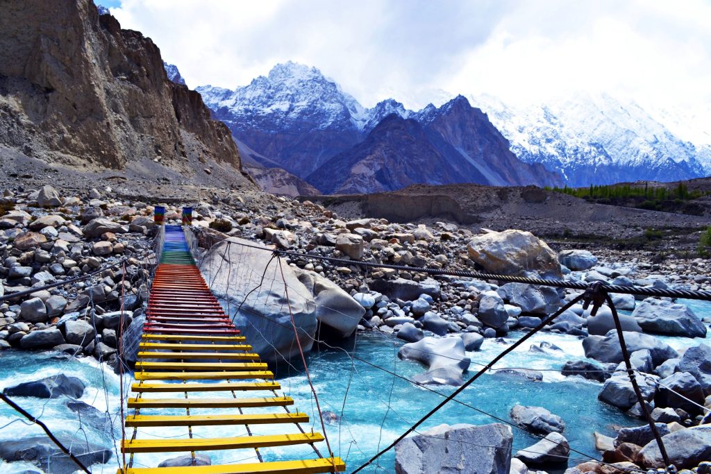
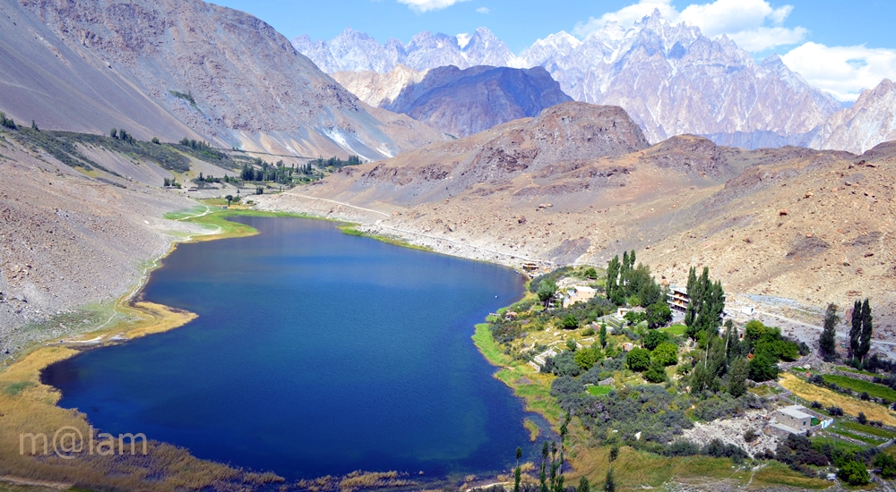
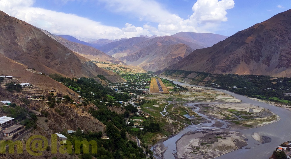
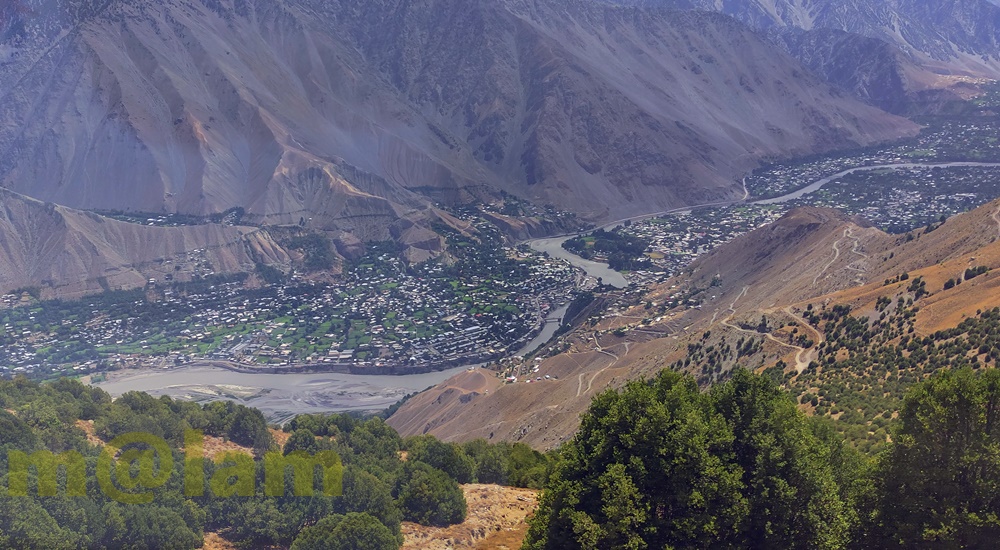
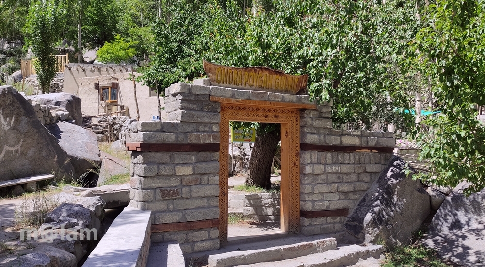
Ondra Poygah: Longest Staircase to a Cultural Marvel Nestled in the breathtaking landscape of Upper Hunza, the Ondra Poygah trail is a tribute to human perseverance, community spirit, and cultural preservation. This remarkable track, created during the winter of 2020/2021, serves as both a historical landmark and a pioneering venture aimed at promoting eco-tourism and adventure tourism in Gilgit-Baltistan. What is Ondra Poygah? The name “Ondra Poygah” combines the historical significance of Ondra Fort and the Wakhi word “Poygah,” meaning staircase. This project, conceived and executed by the dedicated people of Gulmit, transforms the climb to the ancient fort into a trail of cultural and scenic wonder. With 1655 stairs, this extraordinary staircase is the longest and highest in Pakistan, stretching approximately 4 kilometers and gaining an elevation of 1560 meters. The trail begins at the Gulmit Polo Ground and ends at the site of the ancient Ondra Fort, offering a captivating journey through history and nature. A Community-Driven Endeavor Ondra Poygah stands as a shining example of community collaboration. With no external funding or advanced machinery, over 200 volunteers from Gulmit worked tirelessly to construct the trail during the freezing winter months, when temperatures plummeted to -15°C. Men’s Role: Volunteers cut and blasted rock manually, dividing the tasks into manageable sections under the supervision of elders. Teams for management, finance, and marketing ensured seamless execution. Women’s Role: Around 30-40 women provided essential support by delivering fresh, home-cooked meals, tea, and snacks to the workers, braving harsh weather conditions to sustain the community effort. This project was not just about building a staircase; it was about bringing the community together, celebrating their heritage, and creating something remarkable for generations to come. Historical Roots of Ondra Poygah The origins of Ondra Poygah date back centuries. The Ondra Fort, now in ruins, once served as a strategic lookout point for the rulers of Hunza. In ancient times, peaks like Ondra were essential for monitoring enemy movements and organizing defenses. The tradition of “Poygah” became a way to train young men for physical endurance and foster unity within the community. Though the fort no longer stands, the newly constructed trail keeps its memory alive, linking the past with the present. Breathtaking Location and Scenic Views Situated atop a hillock, the Ondra Poygah trail offers 360-degree panoramic views of Gulmit and its surrounding wonders. To the south lies the serene Attabad Lake, while to the north, the trail is framed by the majestic Passu Cones, Borith Lake, and the Batura Range. The east and west reveal the grandeur of the Karakoram Mountain Range and the Hunza River, respectively. From the summit, trekkers can enjoy iconic sights such as the Passu Cones, Sheshper Peak, Gulmit Tower, and the charming Ghulkin Village. Seasonal Splendor One of the most enchanting aspects of the Ondra Poygah trail is its transformation through the seasons: Spring: A burst of pink and white as cherry, apricot, and almond blossoms adorn the valleys. Summer: A lush green landscape that brings life to the surrounding terrain. Autumn: A vibrant palette of orange, yellow, and red, showcasing nature’s artistry. Winter: A serene white blanket of snow, offering a peaceful and magical ambiance. Why Visit Ondra Poygah? Adventure and Eco-Tourism: A thrilling trek combined with a sustainable approach to tourism. Cultural Heritage: A tribute to the rich history of the Upper Hunza region and the resilience of its people. Unparalleled Views: A feast for the eyes with stunning vistas of mountains, lakes, and valleys. Community Spirit: A chance to experience firsthand the unity and hospitality of the Wakhi people. A Legacy of Strength and Unity The Ondra Poygah trail is more than a tourist attraction; it is a living symbol of the resilience, hard work, and creativity of the people of Gulmit. As a blend of history, culture, and natural beauty, this trail is a must-visit destination for travelers seeking adventure and meaningful connections with the heritage of Gilgit-Baltistan. Plan Your Visit Whether you’re an avid trekker, a history enthusiast, or simply someone seeking serenity in nature, the Ondra Poygah trail offers an experience like no other. Explore this hidden gem in the heart of Hunza and witness the unparalleled beauty and spirit of one of Pakistan’s most iconic regions. How to Reach Ondra Poygah Ondra Poygah trail starts from the polo ground in the Gulmit Valley, approximately 130 km from Gilgit and 30 km from Karimabad along the Karakoram Highway. Public transport and private vehicles can be used to reach the site. Nearby Attractions Ondra Poygah is situated in a region renowned for its scenic beauty. Visitors can combine their trip with other nearby attractions: Haldikish Attabad Lake Borith Lake Afsang View Point Hussaini Suspension Bridge Passu Glacier Rainbow Adventure Bridge Batura Glacier Passu Cones Gircha Mosque Khunjerab Pass

Rainbow Adventure Bridge
Gilgit-Baltistan

Rainbow Adventure Bridge

Rainbow Adventure Bridge – A blend of adventure and Scenery Nestled in the breathtaking landscape of Gilgit-Baltistan, Pakistan, the Rainbow Adventure Bridge is an iconic addition to the attractions along the Karakoram Highway. Positioned at the northern end of Upper Passu Valley in Gojal, Hunza, this striking suspension bridge, with its vibrant colors and ingenious design, has become a symbol of adventure tourism in the region. A Visionary Initiative The Rainbow Adventure Bridge is a youth-led initiative aimed at attracting adventurers and cultural enthusiasts to Hunza. Adorned with brilliant hues, this bridge is more than a crossing—it’s an embodiment of creativity, resilience, and local craftsmanship. Supported by durable steel cables and sturdy wooden planks, the bridge ensures a safe yet thrilling passage over the Hunza River, offering a unique experience for travelers. The Thrill of Crossing the Bridge Walking across the bridge is an exhilarating experience. Each step on the gently swaying planks brings a subtle vibration, accompanied by the soothing sounds of suspension cables creaking and the rushing river below. The views are unparalleled: the sparkling Hunza River flows beneath, while the surrounding snow-capped peaks of the Karakoram Range form a dramatic panorama that leaves visitors awestruck. A Photographer’s Paradise For photography enthusiasts, the Rainbow Adventure Bridge is a true inspiration. The striking combination of vibrant colors, natural beauty, and the architectural elegance of the bridge offers countless opportunities to capture mesmerizing shots. Whether it’s a wide-angle view of the bridge against the majestic mountains or a close-up of its intricate details, the location is a dream for visual storytellers. Cultural Immersion A visit to the Rainbow Adventure Bridge is not just about its architectural wonder but also a journey into the heart of Hunza’s rich culture and traditions. The warm hospitality of the locals, their vibrant customs, and the timeless charm of the region make the experience even more meaningful. As you pause on the bridge, take a moment to embrace the serene surroundings. Breathe in the crisp mountain air, and let the beauty of Gojal, Hunza, fill your soul. A Symbol of Resilience The Rainbow Adventure Bridge is more than just a practical crossing; it is a testament to the resilience and resourcefulness of the local community. For generations, the people of Hunza have built and maintained remarkable structures in this challenging terrain. The bridge stands as a tribute to their enduring spirit and determination, showcasing a harmonious blend of practicality and aesthetics. Exploring the Surrounding Wonders Adventure seekers will find the Rainbow Adventure Bridge a gateway to numerous hikes and treks in the area. The trails lead to hidden valleys, ancient glaciers, and awe-inspiring viewpoints, offering endless opportunities to explore the untouched beauty of Hunza and Gojal. Best Time to Visit To fully appreciate the bridge’s vibrant colors and scenic surroundings, plan your visit during spring, summer, or autumn: Spring and Summer: Lush greenery, blooming wildflowers, and clear skies provide the perfect backdrop. Autumn: The foliage turns golden, creating a magical atmosphere that enhances the bridge’s appeal. Responsible Tourism The Rainbow Adventure Bridge holds a special place in the hearts of the local community. Visitors are encouraged to respect its beauty and contribute to its preservation by practicing responsible tourism. Dispose of waste properly, leave no trace behind, and cherish the pristine environment. Ticket: The ticket for crossing the bridge is Rs. 200 Nearby Attractions While visiting the Hussaini Suspension Bridge and zipline, explore other iconic sites in Hunza: Attabad Lake Haldikish Borith Lake Afsang View Point Ondra Poygah Passu Glacier Yak Grill Batura Glacier Hussaini Suspension Bridge and Zipline Passu Cones Gircha Mosque Sost Town Khunjerab Pass

Borith Lake
Gilgit-Baltistan, Lakes

Borith Lake

Borith Lake – A Captivating Tourist Attraction Nestled amidst the rugged beauty of the Karakoram Range, Borith Lake is a hidden gem in the upper Hunza Valley, Gilgit-Baltistan, Pakistan. The lake offers breathtaking scenery, peaceful surroundings, and serves as a gateway to adventure. Located at an easy access from the Karakoram Highway in Hussaini Village, Borith Lake is an increasingly popular destination for nature lovers, trekkers, and photographers. Borith Lake lies at an elevation of approximately 2,600 meters (8,530 feet) above sea level. The lake is situated about 2 kilometers north of the village of Hussaini, which itself is known for its iconic Hussaini Suspension Bridge. The turquoise waters of Borith Lake are surrounded by rolling hills, snow-capped peaks, and sprawling pastures, making it a perfect retreat for anyone seeking tranquility. History and Formation  The lake is a glacial-fed body of water, formed as a result of runoff from the mighty glaciers of the Karakoram Range. Its waters are stock up primarily by the Gulmit Glacier, which is a part of the vast Hunza River system. The lake holds historical significance for the Wakhi community, who have inhabited the region for centuries and consider it a spiritual and cultural hub. Salient Features  Pristine Natural Beauty Borith Lake is renowned for its crystal-clear waters that reflect the surrounding snow-laden peaks, creating an otherworldly panorama. The seasonal colors of the landscape—vivid greens in spring and summer, golden hues in autumn, and snow-blanketed terrains in winter—add to its year-round appeal. Birdwatcher’s Paradise For ornithologists and bird enthusiasts, Borith Lake is a prime spot during spring and autumn migrations. It serves as a temporary haven for flocks of ducks, geese, and other waterfowl as they travel between Siberia and the Indian subcontinent. Trekking and Hiking The lake is a starting point for several trekking routes including Afsang View Point, trek to the Passu Glacier, and Patundas Trek. The moderate-level hike to the Afsang View Point and Passu Glacier offer stunning views of glaciers, moraines, and the surrounding peaks. While the Patundas Trek is a well-known trek requires to cross the Passu Glacier and reach the end of Passu Valley. It provides magnificent views of mighty mountains and of Batura range and Glacier. Another popular trek is to the Gulmit Glacier, which offers a closer look at the fascinating geological formations of the region. Boating in the Lake One of the salient features of the calm lake is boating in its calm waters while enjoying the scenery of surrounding mountains. Camping and Stargazing Camping at Borith Lake is an unforgettable experience. The lack of light pollution in the area makes it one of the best spots for stargazing in Pakistan. On clear nights, the sky comes alive with countless stars, creating a magical ambiance for overnight campers. Photography For photographers, Borith Lake offers an endless array of subjects, from its tranquil waters to the dramatic backdrop of the Passu Cones, one of the most photographed peaks in the Hunza Valley. Accommodations and Facilities While Borith Lake is a relatively remote destination, there are several options for accommodation nearby. Borith Lake Resort, situated on the banks of the lake, provides basic lodging with incredible views. For those seeking a more authentic experience, nearby villages like Gulmit offer homestays and guesthouses where visitors can immerse themselves in the local Wakhi culture. Local Cuisine Don’t miss the chance to savor traditional Wakhi and Hunza organic dishes like chapshuro (meat-filled bread) and daudo (noodle soup) at the local restaurants. Many local eateries use organic ingredients sourced from their own farms, ensuring a fresh and delightful dining experience. Best Time to Visit Borith Lake The ideal time to visit Borith Lake is between April and October, when the weather is pleasant and the trekking routes are accessible. During spring and summer, the lush greenery and blooming wildflowers add to the lake’s charm. Autumn offers golden landscapes, while winter turns the area into a snow-laden wonderland, perfect for those seeking solitude. How to Get to Borith Lake Reaching Borith Lake requires a mix of travel by road and hiking. From Gilgit, the central hub of northern Pakistan, visitors can embark on a 125-kilometer journey to Gulmit. From there, a 4×4 jeep or a short trek brings you to this serene lake. The final stretch, a dirt trail, is best suited for those with a love for adventure. Cultural Significance The lake is not just a tourist attraction; it is deeply intertwined with the lives of the local Wakhi people. Festivals and rituals often take place near its shores, offering visitors a chance to witness and participate in traditional customs that have been preserved for generations. Environmental Concerns and Sustainability Like many natural treasures, the  Lake faces environmental challenges due to climate change and increased tourism. Visitors are encouraged to practice eco-friendly tourism, such as carrying reusable items and minimizing waste. Preserving the pristine environment of this lake is crucial for the local ecosystem and future generations. Why You Should Visit Borith Lake Whether you’re an adventurer, a nature lover, or someone seeking peace and serenity, Borith Lake has something to offer. Its mesmerizing landscapes, cultural richness, and opportunities for exploration make it a must-visit destination for anyone traveling to northern Pakistan. Nearby Attractions While visiting Borith Lake, explore other iconic sites in Hunza: Afsang View Point Ondra Poygah Attabad Lake Haldikish Hussaini Suspension Bridge and Zipline Rainbow Adventure Bridge Passu Glacier Yak Grill Passu Cones Batura Glacier Sost Town Khunjerab Pass

Chaukandi Tombs
Heritage Sites in Pakistan, Islamic Heritage, Monuments, Sindh, Tombs, World Heritage Sites

Chaukandi Tombs

Expanding across a two-square-mile area, the Chaukandi Tombs near Karachi form an ancient Islamic burial site. The Chaukandi Tombs are renowned for its detailed sandstone carvings. These tombs bear a stylistic similarity to the elaborate graves located at the Makli Necropolis, one of the six UNESCO World Heritage Sites, near Thatta. Displaying the distinctive funerary architectural style typical of lower Sindh, the Chaukhandi Tombs undoubtedly provide a fascinating insight into the historical and artistic legacy of the region. History of Chaukandi Tombs: The Chaukhandi graveyard is attributed to the Jokhio tribe of Sindh. At the same time, other Sindhi tribes like Burfat, Jakhra, and Shaikh tombs are also found. The graveyard was constructed during the Mughal rule from the 15th to the 18th century, a period dominated by Islam. In addition to the Jokhio tribe, various Baloch tribes with Rajput origins have found their final resting place here. The influence of the Rajput tribe is evident in the design of the tombs. The step-shaped graves basically showcase a blend of cultures. For instance, some graves feature Rajput characteristics like monumental pedestals and slabs, while others exhibit simpler decorations, resembling a child’s drawing of a human face. Likewise, some tombs lack any human figures, reflecting Islamic beliefs and contributing to the diverse historical tapestry preserved in the Chaukhandi necropolis. The majority of the tombs at Chaukhandi especially represent family graveyards. However, only a limited number placed beneath pillar canopies that exhibit a Hindu architectural style. On certain male graves, intricate carvings depict a horseman equipped with arms such as a shield, sword, bow, and arrow. Meanwhile, carvings on women’s graves portray ornamental details like bracelets, necklaces, rings, anklets, and more. Additionally, for male graves, a boss-shaped projection at the northern end is designed to secure the turban of the deceased. These detailed carvings provide insights into the cultural and personal attributes of the individuals interred at Chaukhandi. Design of Chaukandi Tombs: The tombs at Chaukhandi stand out as a distinctive illustration of surface burials. Unusually aligned from south to north, a departure from the norm in both the region and period, these tombs are crafted from substantial sandstone slabs intricately arranged to form refined pyramid shapes. The meticulous carving on these slabs showcases intricate patterns, drawings, and scenes that contribute to the unique artistic and historical significance of the Chaukhandi Tombs. The absence of precise dating inscriptions on the Chaukhandi Tombs makes it challenging to determine their exact historical timelines. A typical casket consists of six vertical slabs, with two placed at the head and foot of the grave and the remaining four covering the sides, accommodating the length of the body. The tomb takes on a pyramid-like shape, featuring six large slabs covered by another tomb comprising six smaller vertical slabs. The architecture of Chaukandi Tombs: These tombs explicitly represent a unique blend of Sindhi and Balochi architectural styles. Crafted from beige-colored sandstone, these tombs come in the form of single graves or clusters, containing up to eight tombs. Despite the challenges posed by the region’s arid climate, these tombs have endured, serving as a resilient testament to the culture and heritage of the area. Chaukhandi Tombs, a form of funerary architecture, are characterized by square-shaped structures. Its five horizontal slabs enclosing the upper part of the tomb. Notably, these structures often exhibit a carved knob resembling a crown or turban at the front. Graves of warriors from the tribe boast intricate designs and motifs, including depictions of horsemen, jewelry, and hunting scenes. In contrast, tombs of women showcase carvings of anklets, bracelets, and jewelry at the front rather than human figures. Men’s graves typically feature carvings of swords, symbolizing their role as protectors of the tribe during times of war. Distinctive Features of Chaukandi Tombs: The Chaukhandi Tombs exhibit several distinctive features: The most prominent visual characteristic of Chaukhandi tombs is their cone-shaped roofs, constructed using bricks or stones and mortar. This design choice was made to distribute the weight of the structure over a larger area, enhancing stability and durability. The walls of Chaukhandi tombs are built in a beehive formation. The tombs feature multiple layers of stones arranged in a stepped pyramid shape. Constructed from local stones and bricks, these walls often bear decorative designs. Inside each tomb, there is typically a dedicated prayer chamber. This space actually serves for mourning and remembrance of the departed. Accompanying every tomb is a raised grave platform, situated above the surrounding landscape. This platform serves as a place for the family of the deceased to conduct rituals related to the burial. Discovery of Chaukandi Tombs: The Chaukhandi Tombs gained historical recognition with the earliest reference found in a letter written by J. Macleod, a Scottish historian, to Sir Henry Bartle Edward Frere, a British administrator, in 1851. However, it was H. D. Baskerville, the Assistant Collector of Thatta in Karachi in 1917, who brought these historical graves into prominence. In 1922, the site was officially included in the Ancient Monuments Preservation Act. Jean Philippe Vogel, a distinguished Dutch epigraphist employed by the Archaeological Survey of India from 1901 to 1914, played a crucial role in shedding light on the tombs. His extensive research revealed that many of these tombs belonged to Muslims. It was evident from the Arab script inscribed on their graves. Vogel’s findings provided valuable historical insights into the religious heritage of India. Post-independence, scholars and historians continued their in-depth investigations into the Chaukhandi Tombs. Rubbings of these tombs were displayed globally, capturing the attention of academics and sparking further research into this significant archaeological site. Recommendations: Chaukhandi Tombs are highly recommended to visit for individuals passionate about archaeology and history. The site holds a wealth of historical narratives. If you’re intrigued, plan your visit to this amazing site. Apart from the rich decoration adorning the tombs, another noteworthy aspect shared with similar necropolises worldwide is the prevalent local belief that the area is haunted. The Chaukhandi Tombs are reputed to be one of the most haunted sites in the

Kot Diji Fort
Forts, Islamic Heritage, Monuments, Sindh

Kot Diji Fort

The Khairpur district in the Sindh province is renowned for housing several remarkable monuments showcasing architectural marvels, and one of them is the Kot Diji Fort from the Talpur Era. This historical edifice’s structure remains standing, preserving its grandeur for visitors to admire. The name “Kot Diji Fort” is derived from the Sindhi language phrase “Diji jo Qilo,” which translates to “Fort of the Daughter.” History of Kot Diji Fort The history of Kot Diji Fort reveals its significance during the Talpur Era in the Khairpur district of Sindh. The fort was divided into three parts among the Talpurs, with each portion falling under the control of different Talpur rulers. Mir Sohrab Khan was the first Talpur ruler of Khairpur Mirs and founder of the Kingdom of Upper Sindh. He played a crucial role in fortifying the frontiers of his rule. Among the forts he commissioned, Kot Diji Fort stands out as an architectural marvel. Mir Sohrab Khan constructed Kot Diji Fort in the capital town of Kotdiji, making it his residence a few years before his death. The fort was eventually handed over to his sons. Notably, in January 1843, during the military campaign led by Charles Napier to conquer Imam Garh, British troops also stayed at Kot Diji Fort. What adds to the historical significance of Kot Diji Fort is its location on the archaeological site of the pre-Harappan civilization, dating back to 2500-3000 BC. This unique aspect, combined with its association with Mir Sohrab Khan and the British military presence, makes Kot Diji Fort a prominent tourist attraction in Sindh. The fort stands as a testament to the rich historical and archaeological heritage of the region. Construction The construction of the remarkable historical monument in Sindh, Kot Diji Fort, spanned a decade, taking place from 1785 to 1795. Initially named “Fort Ahmadabad,” the fort derived its name from Ahmad, a Persian architect. He was credited with designing and engineering its praiseworthy architecture. Strategically located on an elevated landform, the fort was purposefully designed for warfare, enabling a vantage point to monitor potential threats. The fort is enclosed by a 30-foot tall wall, encompassing the uppermost section and resulting in a narrow-width fortress with a perimeter spanning 1.8 kilometers. Three towers, each standing at a height of 50 feet, grace the fort, contributing to its imposing structure. Kot Diji Fort includes various features such as cannon placements, water reservoirs, prisons, courtrooms, ammunition storage, and a small regal residence. The combination of architectural elements and strategic positioning highlights the fort’s historical significance and its role in safeguarding the region during its era of construction. Architecture The Kot Diji Fort is situated on a limestone hill at an elevation of 110 feet. It boasts a construction using kiln-baked bricks. Positioned on the southern end of Rohri Hills, the fort’s choice of bricks, rather than limestone rocks, was likely due to their local availability and the belief that limestone would easily shatter upon impact with cannonballs during a potential attack. Built during a time when cannons were prevalent, the fort’s design incorporates several stations for cannons. Its elevated position on a narrow ridge posed a challenge for enemy cannons, requiring them to fire from a considerable distance with limited accuracy. This strategic advantage meant cannonballs could either hit the hill or overshoot the fort. It would potentially endanger the enemy forces on the other side. Main Entrance The fort’s main entrance is known as the “Shahi Darwaza” or Royal Gate. It stands 13 feet high and 10 feet wide, constructed with wood and reinforced with 234 heavy iron spikes. This engineering feat aimed to prevent any attempts to break open the gate using a heavy contingent of elephants. The gate is situated in the western corner of the northern wall and serves as the sole entrance to the fort. Additionally, three secret passages were incorporated for emergency use. Upon entering through the curved gate, visitors find themselves in a small courtyard guarded by two bastions. It is strategically positioned for fortification and defense. The fort features three towers and multiple designated areas for cannon placements. Specialized zones include roofless rooms called “Barood Khano,” intended for storing ammunition. Other notable features within the fort include heavy bastions, towers, an ammunition depot, a water reservoir, the Mirs’ harem, a prison, a court, and cells for guards and sepoys. Design The fort, designed exclusively for defense, has never faced an attack throughout its history. Its architecture emphasizes simplicity, making it a unique and captivating historical site in Sindh. Fifty strategically placed bastions, such as “Fateh Thul” (Victory Tower), were named to identify their location and purpose, featuring small and large cannons to monitor enemy movements. Rooms Specialized rooms within the fort served specific functions, such as food storage and a lamp godown. A sandstone-made “Pavilion” stands out as a fascinating feature, adorned with beautifully carved arches and platforms. This structure was historically used by the ruler for court sessions. Moreover, it was also used for issuing important orders on significant occasions, adding to the fort’s historical charm and significance. Current Status After the British invasion, the administrative offices of Kotdiji Fort were relocated to Khairpur. The decision certainly led to a gradual decline in the fort’s importance. Subsequently, the fort was repurposed into a central prison, housing notorious criminals from the area and neighboring states. In 1955, following the merger of Khairpur state with Pakistan, the last ruler, Mir Ali Murad Khan Talpur II, handed over the fort to the government. With the 18th Constitutional amendment, the fort came under the custody of the Government of Sindh. Despite its historical significance, portions of the fort are reportedly under the control of influential local families. The government of Pakistan has recognized Kot Diji Fort as a protected heritage site, emphasizing its cultural and historical value. The fort, located in Kot Diji in the Khairpur District of Sindh province, offers breathtaking views with its picturesque landscape and high boundary walls. The scenic beauty of the

Chitral Tourist Attractions
City Breaks, Khyber Pakhtunkhwa, Tourism Blogs, Tourists Destinations in Pakistan

Chitral Tourist Attractions

Chitral, a region in the Khyber Pakhtunkhwa province of Pakistan known for its natural beauty and cultural richness, offers several tourist attractions. Here are some notable places to visit in Chitral: Chitral Town Chitral Town is a bustling hub filled with vibrant markets and bazaars that provide a unique insight into the local way of life. These lively centers exhibit a diverse array of handicrafts, textiles, spices, and souvenirs, offering visitors the opportunity to fully immerse themselves in the vibrant colors and rich flavors of Chitral. Exploring the streets of the magnificent Chitral Town divulges a harmonious blend of traditional and contemporary architecture. The buildings feature intricate designs and elaborate frontages that beautifully showcase the region’s rich cultural heritage. This visual spectacle is sure to captivate architecture enthusiasts, providing a delightful journey through the town’s unique and fascinating aesthetic. Shahi Masjid The Shahi Masjid stands as a magnificent piece of architecture, constructed by Shujaul Mulk, the Mehtar of Chitral, in 1924 A.D. Shujaul Mulk, the ruler of Chitral from 1895 to 1936, left a lasting legacy in the form of this grand mosque. The building itself is a remarkable example of architectural dexterity, constructed with pure white marble and adorned with intricately engraved art. Situated on the bank of the Chitral River, adjacent to the Chitral Fort, the Shahi Masjid is not only a place of worship but also a testament to the rich customs and culture of the Chitral aristocracy. The architectural details of the mosque reflect the traditions of the region, creating a visual representation of Chitral’s cultural heritage. The Shahi Masjid stands as a significant landmark, inviting visitors to appreciate its historical and artistic significance. Chitral Fort The Chitral Fort, also known as Shahi Qila, is a historic fortification located in Chitral town, Khyber Pakhtunkhwa, Pakistan. Positioned on the banks of the Chitral River, it holds a strategic location not far from the Shahi Masjid. The fort is believed to have been initially constructed in 1774 during the reign of Mohtaram Shah Katur II and later restored in 1911 by His Highness Sir Shuja ul-Mulk. Originally serving as the barracks for the guards of the Mehtar of Chitral, the fort became the personal property of the last ruler of Chitral after the merger of Chitral State in 1969. Presently, it is occupied by the ceremonial Mehtar, Fateh-ul-Mulk Ali Nasir. Notably, the fort has undergone renovations, particularly to the old Darbar Hall and staterooms, following damages incurred during the earthquake of 2015. The Chitral Fort stands as a testament to the region’s historical significance and architectural heritage, offering visitors a glimpse into its rich past. Chitral Museum The Chitral Museum stands as a custodian of the unique culture and art of the region, preserving the heritage of ancestors for future generations. Established on July 8, 2010, the primary purpose of the museum is to safeguard Chitral’s cultural legacy for tourists and locals alike. The museum is divided into two distinct sections: the Ethnological Gallery and the Archaeological & Kalash Gallery. In the Ethnological Gallery, visitors encounter artifacts such as jewelry, instruments, and furniture from the 12th century, providing a glimpse into the lifestyle of Chitral’s ancestors. On the other hand, the Archaeological & Kalash Gallery focuses on items related to the Kalash, showcasing the cultural heritage with connections to Greek influences. Particularly noteworthy are the artifacts associated with their gods and goddesses, offering insights into the spiritual and religious practices of the Kalash people. The Chitral Museum serves as a valuable resource for those interested in exploring and understanding the rich cultural history of the region. Governor’s Cottage The Governor Cottage stands as a beautiful and graceful example of Chitrali architecture, showcasing the region’s glorious and distinctive construction style. Situated on elevated grassland, surrounded by mountains, the cottage provides a picturesque setting. On a clear day, visitors can admire the majestic Trich Mir Mountain from this location. Previously reserved, the place is now open to the general public. Inside, one can find a collection of well-preserved historical objects that offer insights into the rich history of the region. The Governor Cottage provides a unique opportunity for visitors to experience and appreciate the royal living style of the Mehtar of Chitral. It serves as a testament to the cultural and historical heritage of the area, allowing individuals to connect with the past and the architectural traditions of Chitral. Chitral Gol National Park Chitral Gol National Park, situated 5,000 meters above sea level in the Lower Chitral District, is a two-hour drive from Chitral town and spans 7,750 meters. This park is renowned for its abundant wildlife and panoramic views of valleys, glaciers, and streams. Formerly considered the private property of the Mehtar of Chitral until 1983, the park’s status has been disputed and is subject to ongoing litigation between the Mehtar’s heirs and the Government of Pakistan. The park encompasses three valleys with glaciers and springs feeding into an 18-kilometer stream flowing east into the River Chitral. Rich in cedar trees, the park provides a habitat for diverse wildlife, including the endangered Kashmir Markhor. Other notable mammals include the Siberian ibex, Snow leopard, Ladakh Urial, Himalayan black bear, Himalayan Wolf, Red fox, Eurasian otter, and Yellow-throated marten. Barmoghlasht Barmoghlasht, a renowned summer retreat in Chitral, is nestled amidst towering mountains and lush greenery, located 14.5 kilometers from Chitral town. Highlighting the area is the former Mehtar’s Summer Fort, strategically perched at an elevation exceeding 2800 meters, providing a captivating view of the city. Notably, it is the ancestral building of the Chitral royal family, adding historical significance to its charm, set amid vibrant green pastures. Accessible by a 40-minute drive from Chitral City, Barmoghlasht is especially enchanting in May and June when spring brings forth lush greenery and vibrant blooms. The resort offers an array of activities, making it an ideal destination for paragliding, hiking, and bird watching in the summer, while also providing opportunities for skiing during the winter months. Tourists are drawn to Barmoghlasht throughout the

Chitral
Khyber Pakhtunkhwa, Tourists Destinations in Pakistan

Chitral

Chitral is one of the spectacular, culturally rich, and prominent tourist destinations in the northern KPK province of Pakistan. The region is home to the mighty Hindukush Mountains and scenic valleys. The entire Chitral is blessed with breathtaking natural beauty. Each of its valleys has its unique attributes that distinguish it from the others.  Its lush green valleys, high-altitude mountains, and scenic glaciers along with the rich culture of the region attract tourists from across the country and the globe every year. Chitral was historically an independent princely state before independence. However, it was the first state to declare accession to Pakistan as a district of Malakand Division in 1970. Geography Chitral town runs along the banks of the Chitral River. The entire Chitral district covers an area of 14,850 km². Out of its total landmass, 4% is forest, 3% cultivated area, and 2% cultivable land while the rest is mountains and barren. Chitral is bordered to the east by Gilgit-Baltistan, southeast with Swat, north and north-east by China and the Wakhan corridor of Afghanistan, west borders Nuristan and Kunar provinces of Afghanistan, and Upper Dir district of Khyber Pakhtunkhwa (KPK) province is situated to the south. Furthermore, Chitral town is the administrative center of the Chital district, which is controlled by the Khyber Pakhtunkhwa government. Districts Chitral itself is a district of KPK province housing a population of 447,362 and is further divided into two districts – lower and upper Chitral by the government of KPK. Chitral is located among the Hindukush Mountains in the northwest of Pakistan. Lower Chitral covers the region from Lowari to Barenis and Gabor on the Garam Chashma side while Upper Chitral starts from Barenis village onwards. History Centrally positioned on the crossroads to Central Asia, Chitral boasts a rich and captivating history. Its strategic location made it a coveted target for invaders, drawing attention before other areas in the region. The documented history of Chitral traces back to the early 8th century AD when Tibetans invaded the Yasin Valley, marking the beginning of a series of invasions. Subsequently, in 900 AD, both the Chinese and Buddhists became part of Chitral’s historical narrative. Later, the Kalash also ruled Chitral for decades. In the 14th century, Chitral became a unified independent under the rule of Shah Nasir Rais while in 1570, the Rais dynasty was replaced by the Katoor dynasty. Likewise, the famous mehtar of Chitral Aman-ul-Mulk ruled from 1857 to 1892. In 1895, the siege of Chitral Fort took place and lasted a month, after which Chitral became an independent state under British rule. Finally, in 1969 it was merged into Pakistan. Today, Chitral hosts ancient Chitrali Tribes as well as nomads who were invited by the mehtars to settle in the state. Chitral is additionally the residence of the ancient pagan tribe, the Kalash, who currently reside exclusively in the three valleys of Bamburat, Rambur, and Birir. Cultural Heritage Chitral’s cultural heritage encompasses a rich tapestry of arts and crafts, traditional clothing, diverse cuisines, local games, music, dance, folksongs, and iconic landmarks. People The Chitrali people call the land of Chitral “Kho” or “Khow” who account for 92% of the population and their language is Khowar. Other tribes include the 3000 Pagan Kalash people living in Bamburet, Rambur, and Birir; the Shubgali tribe living in Gabor, Langoor Butt, and Bamburet and are believed to have come from Nooristan (Afghanistan). The tradition of hospitality is evident across northern Pakistan, but few places match the generous warmth found in Chitral. Clothing Chitral boasts a long and illustrious history that has profoundly shaped its culture. Men in the society typically don Shalwar and Kameez, complemented by the traditional Pakol headwear. Women, on the other hand, wear Khet Partog, traditionally covering their faces with a scarf and adorning their heads with a Dupatta. The Pakol is alternatively referred to as the Chitrali Topi. The region also hosts various festivals featuring Chitrali traditional music, folk tales, and captivating traditional dances performed by both male and female members. Religious affiliation Mainland Chitral and its valleys are home to the Muslim population. However, the majority of the people in Chitral’s Kalash Valley are polytheists who believe in numerous gods. They worship numerous gods and hold a variety of religious festivals. Arts & Craft Chitralis also have a strong taste for music and Chitrali sitar, a string instrument, can often be heard at many places and family gatherings. Chitral’s artisans manufacture a wide range of elegant and delicately crafted jewelry, woodwork and embroidery, woven and knitted textiles. The woolen fabric from Chitral, known locally as “Shu,” and walnut wood furniture are highly sought-after items in handicraft markets across the country. The traditional clothes, including those of the Kalash people, are made from wool and silk and decorated with beads and shells. Traditional caps (Khapol) and gowns (Chugha) are popular while the typical Chitrali shoes (Khon) resemble long-riding boots. Traditional Chitrali buildings are embellished with wood carvings and have been designed keeping in view the climatic and local environmental conditions of the area. Culture Chitral’s culture carries traces of Greek, Iranian, Tatar, and Turkish influences, attributed to its unique location and historical connections with Central Asia and Europe. Chitral’s own culture, which has evolved over millennia and includes more than a dozen ethnic groups communicating as many languages as there are cultures, is strongly tied to those of Central Asia rather than South Asia. Chitral and Kalash people are also known for their incredibly unusual clothing and dances, as well as their love for music (Especially the tribes of Kalash). During festivals, drums are played, and the women dance in a circle while some elderly folks sit on the sidelines and sing old melodies. Languages The predominant language spoken by the locals is Chitrali. Khowar is the most widely spoken language in the region, with 98% of the population speaking it, while Kalash people speak Kalasha. Urdu, the national language, is also spoken and understood by the locals while Pashtu is

British-Cemetery-Gilgit
City Breaks, Gilgit-Baltistan, Tombs

British Cemetery Gilgit

British Cemetery in Gilgit: A Testament to Colonial Legacy Nestled in the breathtaking landscapes of Gilgit, the capital of Gilgit-Baltistan, the British Cemetery, also known as G.W. Hayward Cemetery, stands as a poignant reminder of the region’s colonial past. This serene burial ground not only reflects the legacy of the British Raj’s presence in the Gilgit Agency during the 19th and 20th centuries but also offers visitors a glimpse into the historical and cultural tapestry of the era. Commemorating George W. Hayward The British Cemetery was initially named “Hayward’s Garden” in honor of George W. Hayward, a distinguished British explorer. On July 18, 1870, Hayward became the cemetery’s first internee after being tragically assassinated near Darkot Pass in Ghizer. The Royal Geographical Society of London established his burial site, marked with an inscription commemorating his gallantry and achievements. Hayward’s legacy as an intrepid traveler exploring the Pamir grasslands is immortalized here. Architectural Highlights Encircled by a robust stone wall and featuring ornate wrought iron gates, the British Cemetery Gilgit showcases the architectural finesse of the Victorian era. The grave markers, crafted predominantly from stone, are adorned with delicate engravings and intricate designs, making them artistic marvels in their own right. A Historical Landmark Along the Silk Road Situated along the historic Silk Road, Gilgit was a pivotal hub for trade and administration during the British colonial era. The cemetery was established as a final resting place for British officials, soldiers, travelers, and locals who collaborated with the British in various capacities. Each grave tells a story of courage, exploration, and the intertwined destinies of British and local communities. Notable Figures Buried in the Cemetery The cemetery is home to at least 18 graves of notable individuals who played significant roles during the British era, including: Captain G.W. Hayward: The cemetery’s first occupant, renowned for his exploration of Central Asia. Major William Brown: A prominent figure in the development of the Gilgit Agency. Arthur Francis Bruce: The political agent of Gilgit from 1906 to 1908. Henry Gordon Bell: Political agent of Gilgit, interred on July 25, 1912. Harold S. Eldred: Of the Sikh Pioneers Kashmir Infantry, who tragically drowned in the Indus River in 1929. Additionally, the cemetery contains the graves of travelers and mountaineers, including: Members of the 1959 Batura Muztagh Expedition: Dr. Keith Warburton, Harry G. Stephenson, Richard S. Knight, Martin Guennel, and Albert Hirschbichler. Major Jimmy Mills: Who perished during the Pakistan-British Army Karakoram Expedition. Preserving History and Promoting Tourism The British Cemetery in Gilgit is a treasure trove for history enthusiasts and researchers eager to explore the colonial legacy of the region. Its unique architectural style, coupled with the significant individuals interred within its grounds, makes it a compelling destination for cultural tourism. Efforts to conserve and restore the cemetery have been spearheaded by local authorities and heritage organizations. Restoration work focuses on maintaining the structural integrity of grave markers, repairing damaged monuments, and ensuring the cemetery remains a tranquil space for reflection. Visitor Information Open to the public, the British Cemetery offers visitors a chance to delve into the past while paying their respects to those laid to rest. While guided tours are not officially available, local experts often provide valuable historical insights upon request. Visitors are welcome to take photographs but are reminded to respect the solemnity of the site. A Journey Through Time Visiting the British Cemetery in Gilgit is more than a historical excursion; it is an opportunity to honor the individuals who shaped the region’s history and appreciate the cultural exchange between the British and local communities. As restoration efforts continue, this historic site stands as a cherished monument, attracting travelers and history aficionados from around the globe. Nearby Attractions: Konodas Suspension Bridge Biddulph House & Library Karga Buddha Hanzel Stupa Agortham Boulder Uprising Memorial Gilgit Konodas Rock Carvings Danyore Suspension Bridge Danyore Rock Inscription Chinese Graveyard Danyore The Victory Monument of Taj Mughal

Akbari Sarai from front
Monuments, Punjab

Akbari Sarai

Akbari Sarai: A Marvel of Mughal Architecture in Lahore, Pakistan The enigmatic Akbari Sarai, a treasure trove of Mughal heritage, lies in the heart of Lahore, Punjab, Pakistan. It is nestled gracefully between the magnificent Jahangir’s Tomb and the resplendent Asif Khan’s Tomb. This sprawling oblong-shaped courtyard dates back to 1637. The Sarai boasts a rich history as a haven for travelers and a sanctuary for the guardians of Jahangir’s Tomb. At the same time, it served as a vital postal station known as Dak Chowki. Unveiling the Historical Veil Emperor Shah Jahan’s esteemed court historian, Abdul Hamid Lahori, documented the original designation of this grand edifice as the “Jilu Khana-e-Rauza” (attached court of the tomb) in his magnum opus, “The Padshahnama.” The terminology”Akbari Sarai” emerged during the reign of Islam Shah Suri in the mid-1550s, intriguingly not during the illustrious reign of the Mughal Emperor Akbar. Architectural Marvels Unveiled Spread over a vast expanse of 12 acres, the Akbari Sarai spans an impressive 797 feet by 610 feet. It boasts a perimeter adorned with 180 cells, each featuring a front veranda and a shared passageway. The Sarai’s architectural opulence shines through the presence of four Burjes, each housing intricate chambers. These chambers present an elliptical hall at their forefront, complemented by a veranda and an octagonal chamber at the rear. Access to this architectural wonder is granted through two imposing entrances located to the north and south. These entrances bear the hallmark of Mughal craftsmanship, adorned with captivating frescoes and the exquisite Ghalib Kari. The latter refers to a network of stucco and plaster ribs gracefully applied to the curved surfaces of each archway. Notably, the architectural attributes of the Sarai, including its decorative elements, structural style, and the size of the bricks used in its construction, exhibit the quintessential Mughal aesthetics. Interestingly, the eastern entrance gateway to Jahangir’s tomb is distinguished by its large double-storied iwan. It is further linked with four smaller arched niches, hinting at a concurrent construction period. A Glimpse into the Past Towards the western periphery of the Sarai, amidst the line of cells, rests a mosque dating back to the Suri era. This mosque is characterized by three resplendent domes. Although time has eroded much of its artistic grandeur, the sandstone-facing facade adorned with inlay work still exudes an aura of grace. The cells that grace the complex, along with its ornate gateways, owe their existence to the Shah Jahan period during the mid-1600s. Administrative Marvels The Akbari Sarai, in its heyday, served as an esteemed state guesthouse, overseen by a Shahna (official caretaker) and a team of dedicated assistants. Moreover, the establishment even boasted a resident physician and a skilled baker. Travelers and guests were treated to a range of amenities, including complimentary fodder for their animals, access to both hot and cold water, and comfortable bedsteads. However, as history continued to unfold, the Sarai witnessed various transformations. During the Sikh era, for instance, Maharajah Ranjit Singh repurposed the complex. He converted it into a cantonment for one of his foreign generals, Musa Farangi. Subsequently, during the British colonial period, it took on a new role as a rail depot. Albeit, It suffered significant damage with the construction of a nearby rail line. A Shared UNESCO Dream The Akbari Sarai, along with its illustrious neighbors, Jahangir’s Tomb and the Tomb of Asif Khan, were jointly recognized in 1993 when they were included in the tentative list of UNESCO World Heritage Sites. This recognition underscores their significance as custodians of Mughal history and architectural prowess, captivating the world with their timeless charm. The Akbari Sarai stands as a testament to the glorious Mughal era. It was a period where artistry, architecture, and hospitality converged to create a masterpiece. It continues to enthrall and inspire visitors from around the globe.

Makran Coastal Highway Attractions
Balochistan, City Breaks, Roads & Highways

Makran Coastal Highway Attractions

Exploring the Marvels of Makran Coastal Highway: A Scenic Journey from Karachi to Gwadar The 653-kilometer highway bearing Makran Coastal Highway attractions is also known as National Highway 10 (N-10). The highway seamlessly connects the western province of Sindh with the picturesque landscapes of southern Balochistan. As we delve into the charm of this coastal road that hugs the Arabian Sea, we’ll uncover its hidden treasures, making your trip an extraordinary adventure. The Makran Coastal Highway: A Game-Changer Before the construction of this splendid highway, the arduous unpaved road journey from Karachi to Gwadar would consume two grueling days. However, with the advent of the Makran Coastal Highway, this travel time has been dramatically slashed to a mere 6-7 hours. The key Makran Coastal Highway Attractions dotted along the Highway are unique in all respects on this game-changer highway. Major attractions include: Zero Point: Where the Journey Begins Located approximately 125 kilometers northwest of Karachi, Zero Point serves as the gateway to two significant routes: the RCD Highway leading north to Baluchistan mainland and the N10 Makran Coastal Highway leading westward to Gwadar. It’s a place where cellular networks cease to function, emphasizing the remote and untamed beauty of this region. At this juncture, you’ll encounter a replica of the “Princess of Hope” rock formation, a testament to the region’s unique geography. Local restaurants and tuck shops offer a taste of authentic cuisine, including tea and cookies. For travelers’ convenience, a mosque and outdoor bathroom facilities are available. Hingol National Park: A Biodiversity Hotspot Stretching across an impressive 1,650 square kilometers along the Makran coast in southwestern Balochistan, Hingol National Park is a haven for nature enthusiasts. Established in 1988, this national park boasts a rich biodiversity, with 250 plant species, 35 species of mammals, 65 species of amphibians and reptiles, and 185 species of birds. It’s a must-visit destination for wildlife aficionados. Hingol Mud Volcanoes: Nature’s Artistry Approximately 200 kilometers west of Karachi and 8 kilometers off the main Coastal Highway, the Hingol mud volcanoes, also known as Chandragup Mud Volcanoes, showcase Mother Nature’s artistic prowess. The ever-erupting clay formations in Hingol National Park create a surreal landscape, making it a sacred site for Hindu worship. Local guides are your best bet for finding these hidden gems. Hinglaj Mandir: An Ancient Pilgrimage Site Situated in the heart of Hingol National Park, Hinglaj Mandir, also known as Hinglaj Mata, is an ancient Hindu temple and one of the world’s oldest. Nestled in a narrow gorge on the west bank of the Hingol River, this sacred site features a small, shapeless stone adorned with Sindoor (Vermilion) and worshipped as Hinglaj Mata. It’s a spiritual journey into the past. Kund Malir Beach: A Slice of Paradise Located around 145 kilometers from Zero Point and 270 kilometers from Karachi, Kund Malir Beach is a pristine coastal gem. Despite the lack of basic facilities like hotels and restaurants, it boasts a serene and soothing environment. The drive along the Coastal Highway becomes a delight as you soak in the breathtaking beauty of this world-renowned beach. Golden Beach: Nature’s Abode Situated just 2 kilometers from Kund Malir Beach, Golden Beach, also known as Malan Beach, is a less-explored paradise. Its limited facilities and steep gradient from the main Coastal Highway make it a quiet escape. Golden Beach is not only a haven for Green Turtles but also a wintering ground for over 50 species of migratory birds, making it a birdwatcher’s delight. Its golden sands and untouched beauty make it an eco-tourism hotspot. Princess of Hope: Nature’s Masterpiece The “Princess of Hope” remained hidden until Hollywood actress Angelina Jolie’s visit in 2002. This naturally carved rock formation, located around 275 kilometers from Karachi, stands tall as a testament to nature’s artistic abilities. Weathering the test of time, it adds a touch of mystery to your journey along the Makran Coastal Highway. The Sphinx of Makran Approximately 150 kilometers from the Zero Point of the Makran Coastal Highway and 280 kilometers from Karachi, you’ll encounter another natural wonder: the Sphinx-like structure. This formation, created by the relentless winds blowing through the region’s muddy hills, bears a resemblance to the Egyptian Sphinx. Although not as sharply shaped, it’s a unique sight worth seeing. Ormara Beach: A Historical Oasis Located about 360 kilometers west of Karachi and 230 kilometers east of Gwadar, Ormara Beach offers a pristine coastline with spectacular sunrise and sunset views. Named after General Ormoz, who accompanied Alexander the Great during his conquests, it holds historical significance. The Haft Talar tourist resort, overlooking the beach, provides a range of outdoor activities, from concerts to bird-watching. Pasni: A Historical Haven Pasni is an important small town and a fishing port in the Arabian Sea. The beachside is off the main Coastal Highway, 40km to the coastal area about 100km short of Gwadar. Pasni is an important small town and a fishing port at the Arabian Sea, off the main Coastal Highway, 40km to the coastal area about 100km short of Gwadar. Its significance relates to the discovery of rock formations including the ancient ruins of the Harappan era the presence of antique Hindu temples, and proofs of Alexander’s passing the coastal belt. Astola Island About 25 km south of the nearest part of the coast and 39 km southeast of the fishing port of Pasni is a small uninhabited island called Astola Island or Jazira Haft Talar. It is known to be the largest offshore Island measuring 6.7 km long and 2.3 km wide, and 246 ft above sea level. The Island is accessible by motorboat in about 5 hours or by helicopter. It is a popular eco-tourism destination with no lodging facilities on the Island. Anyone planning for an overnight stay must carry a tent and food. The Island is famous for scuba diving, fishing, and observing turtle breeding. Gwadar: The Gateway of Wind The term Gwadar is a combination of two Balochi words Gwat (meaning the wind) and Dar (meaning Gateway) thus Gwadar

Scroll to Top