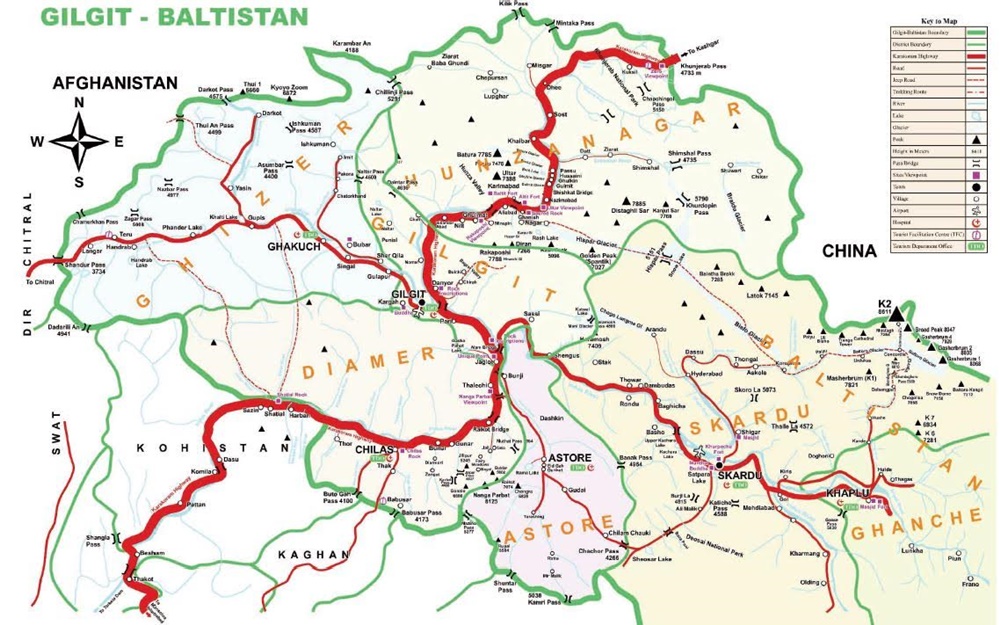
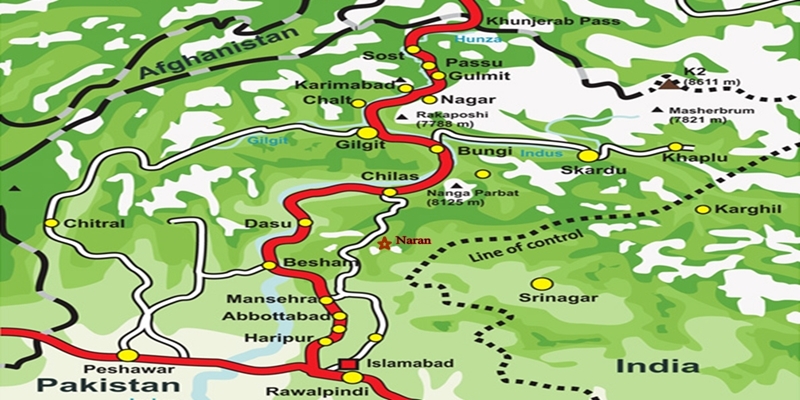
City Breaks

The Hunza Valley
City Breaks, Gilgit-Baltistan, Tourism Blogs

The Hunza Valley

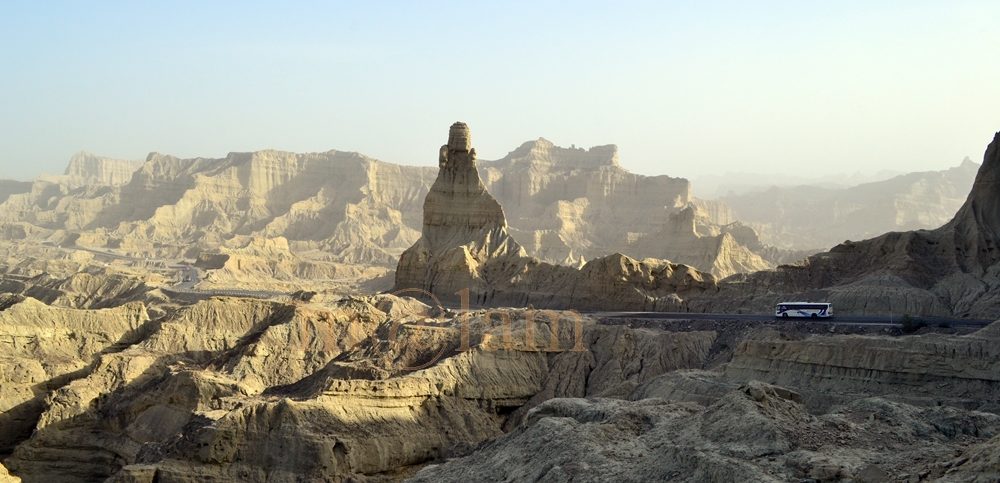
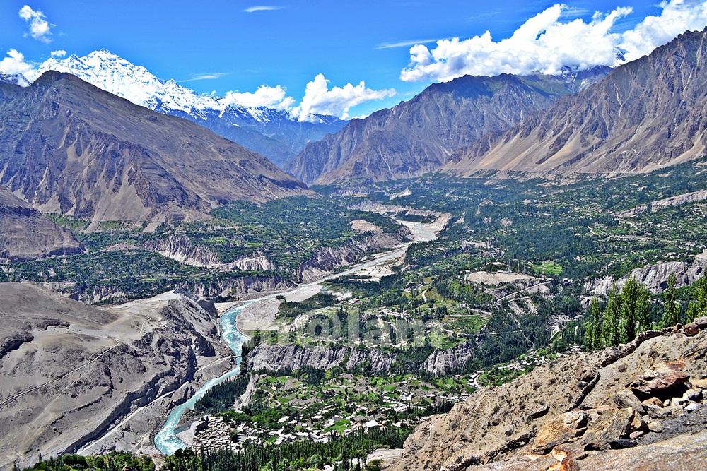
The Hunza Valley – A Place Beyond Words Welcome to The Hunza Valley, a Majestic Gem of Nature’s Grandeur – a place where nature’s beauty meets cultural heritage. Nestled in the heart of the mighty Karakoram Mountains, this remote valley is a hidden gem waiting to be explored. The words may fall short of capturing the true essence of The Hunza Valley. It is a place that needs to be experienced firsthand, where the mountains whisper ancient tales, and the valleys echo with the laughter of the locals. The serenity, the adventure, and the warmth of the people combine to create an unparalleled experience that will stay with you long after you leave. From its awe-inspiring landscapes to the warm hospitality of its people, the Hunza Valley offers a truly extraordinary experience that will leave you mesmerized. The Majestic Karakoram Range At the heart of The Hunza Valley lies the magnificent Karakoram Range. Towering peaks, snow-capped mountains, and sprawling glaciers adorn the landscape, creating a sight that will take your breath away. The Karakoram Range is home to some of the highest peaks in the world. Notable mountain peaks include K2, the second-highest mountain on earth, Broad Peak, and Gashabrum Peaks. Explore the stunning beauty of these majestic giants and immerse yourself in the grandeur of nature. Cultural Heritage and Warm Hospitality The Hunza Valley is steeped in rich cultural heritage. The local communities have preserved their traditions for centuries, and their warm hospitality will make you feel right at home. Engage with the locals, learn about their customs and traditions, and savor the flavors of their delectable cuisine. Immerse yourself in their vibrant festivals and witness the traditional dances that reflect the valley’s vibrant spirit. Traditional Music & Rituals Hunza is known for its rich cultural heritage, including traditional music and rituals. The people of Hunza have a distinct cultural identity, and their music and rituals are an integral part of their social and religious practices. Music holds a significant place in Hunza’s cultural traditions. In addition to their music, the people of Hunza have various rituals and celebrations that hold cultural and religious significance. Some of the notable rituals and celebrations include Ginani, Nasalo, Bofao, Nawruz, Salgirah of Imam e Zaman, Shab e Barat, Shab e Meraj, Eid Gadeer, Eid ul Fitr, and  Eid ul Adha. Traditional Cuisine  The valley is also famous for its delectable cuisine, featuring a variety of local dishes such as Chapshuro, Gurey Fiti, Makaye Fiti, Makaye Faqo, Burus Shapik, Giyaling, Hamao Giyaling, Hoi Lo Garma, Diram Fiti, Batering Dawdo, Buqpa Dawdo, Chap tze Dawdo, Haniye Del (Apricot Oil), Hani tze Dawdo, Hani tze Chamic (Apricot Sauce), Harisa, Sharbat, Mulida, Shopan, Chhamus,  and apricot-based desserts. The organic produce grown in the region, including cherries, apricots, and almonds, adds to the culinary delights of the valley. The Kha Basi Café on the premises of Altit Fort, Café De Hunza at Karimabad, Mulberry Hotel, Darbar Hotel, and Hidden Paradise offer a great taste of traditional food. Fruits of the Hunza Valley The journey of fruits in Hunza begins with cherries in May after the blossom season concludes in April and varieties of fresh fruits remain available until November. During winter, a variety of dry fruits and byproducts made of dry fruits are available in the market. Seasonal fruits include black, red, and white Cherries in May and June; Plum, Figs, and a variety of Apricots in June and July; Apples in July & August, a variety of grapes in August and September, Peach in September and October, and Japanese fruit in November. Outdoor Activities Exploring the Hunza Valley offers numerous outdoor activities for adventure enthusiasts. Visitors can embark on a thrilling trek to Ultar, hike up to Duikar from Karimabad or Altit, walk along the Hunza water channel or to viewpoints for panoramic vistas, go rock climbing, indulge in mountain biking, Paragliding from Duikar, or walk surrounding valleys. There are other exciting options including a trip to upper Hunza which covers the beautiful road trip to Khunjerab Pass, Rainbow Bridge Photography, a day hike towards Batura Glacier, visiting Borith Lake and walk up to the glacier, a day hike from Borith to Husseni village, Husseni Suspension Bridge crossing & Zip Line experience, hike up to Ondgra Poyga, explore Shishkat valley, boating at Attabad Lake, and visiting the magnificent Hoper Valley. The Karakoram Highway, which passes through the valley, provides an adventurous road trip experience with stunning vistas at every turn. Shopping in Hunza Karimabad, also known as Baltit, is the main bustling market with various shops, stalls, and local vendors selling a wide range of items in Hunza. Exquisite handicrafts such as carpets, rugs, embroidered textiles, traditional caps, shawls, and wooden carvings make for great souvenirs or gifts. Hunza is also famous for its gemstones and jewelry displayed in a variety of gemstone stores offering precious and semi-precious stones like turquoise, garnet, topaz, and more. Additionally, unique jewelry pieces inspired by the local culture are also seen on display. Moreover, delicious dried fruits, nuts, and apricot products including dried apricots, apricot oil, apricot jams, and apricot-based sweets like Hunza halwa. These local delicacies are a must-try and can be found in many shops. Similarly, traditional clothing such as embroidered shirts, woolen waistcoats, caps, gowns, and shawls featuring local craftsmanship and the cultural heritage of the region is easy to find in the market. Seasonal Attractions Blossoming Orchards The Hunza Valley is renowned for its vibrant orchards. As spring arrives, the valley transforms into a breathtaking paradise with the blooming of cherry, apricot, peach, and pear trees. The delicate pink and white blossoms create a picturesque scene, attracting visitors from far and wide. Take a leisurely stroll through the orchards, breathe in the sweet fragrance, and witness nature’s exquisite artistry unfold before your eyes. A Great Summer Retreat Certainly! The Hunza Valley is a breathtaking summer retreat. During the summer months, the Hunza Valley transforms into a paradise for travelers seeking respite from the scorching heat. The

British-Cemetery-Gilgit
City Breaks, Gilgit-Baltistan, Tombs

British Cemetery Gilgit

British Cemetery in Gilgit: A Testament to Colonial Legacy Nestled in the breathtaking landscapes of Gilgit, the capital of Gilgit-Baltistan, the British Cemetery, also known as G.W. Hayward Cemetery, stands as a poignant reminder of the region’s colonial past. This serene burial ground not only reflects the legacy of the British Raj’s presence in the Gilgit Agency during the 19th and 20th centuries but also offers visitors a glimpse into the historical and cultural tapestry of the era. Commemorating George W. Hayward The British Cemetery was initially named “Hayward’s Garden” in honor of George W. Hayward, a distinguished British explorer. On July 18, 1870, Hayward became the cemetery’s first internee after being tragically assassinated near Darkot Pass in Ghizer. The Royal Geographical Society of London established his burial site, marked with an inscription commemorating his gallantry and achievements. Hayward’s legacy as an intrepid traveler exploring the Pamir grasslands is immortalized here. Architectural Highlights Encircled by a robust stone wall and featuring ornate wrought iron gates, the British Cemetery Gilgit showcases the architectural finesse of the Victorian era. The grave markers, crafted predominantly from stone, are adorned with delicate engravings and intricate designs, making them artistic marvels in their own right. A Historical Landmark Along the Silk Road Situated along the historic Silk Road, Gilgit was a pivotal hub for trade and administration during the British colonial era. The cemetery was established as a final resting place for British officials, soldiers, travelers, and locals who collaborated with the British in various capacities. Each grave tells a story of courage, exploration, and the intertwined destinies of British and local communities. Notable Figures Buried in the Cemetery The cemetery is home to at least 18 graves of notable individuals who played significant roles during the British era, including: Captain G.W. Hayward: The cemetery’s first occupant, renowned for his exploration of Central Asia. Major William Brown: A prominent figure in the development of the Gilgit Agency. Arthur Francis Bruce: The political agent of Gilgit from 1906 to 1908. Henry Gordon Bell: Political agent of Gilgit, interred on July 25, 1912. Harold S. Eldred: Of the Sikh Pioneers Kashmir Infantry, who tragically drowned in the Indus River in 1929. Additionally, the cemetery contains the graves of travelers and mountaineers, including: Members of the 1959 Batura Muztagh Expedition: Dr. Keith Warburton, Harry G. Stephenson, Richard S. Knight, Martin Guennel, and Albert Hirschbichler. Major Jimmy Mills: Who perished during the Pakistan-British Army Karakoram Expedition. Preserving History and Promoting Tourism The British Cemetery in Gilgit is a treasure trove for history enthusiasts and researchers eager to explore the colonial legacy of the region. Its unique architectural style, coupled with the significant individuals interred within its grounds, makes it a compelling destination for cultural tourism. Efforts to conserve and restore the cemetery have been spearheaded by local authorities and heritage organizations. Restoration work focuses on maintaining the structural integrity of grave markers, repairing damaged monuments, and ensuring the cemetery remains a tranquil space for reflection. Visitor Information Open to the public, the British Cemetery offers visitors a chance to delve into the past while paying their respects to those laid to rest. While guided tours are not officially available, local experts often provide valuable historical insights upon request. Visitors are welcome to take photographs but are reminded to respect the solemnity of the site. A Journey Through Time Visiting the British Cemetery in Gilgit is more than a historical excursion; it is an opportunity to honor the individuals who shaped the region’s history and appreciate the cultural exchange between the British and local communities. As restoration efforts continue, this historic site stands as a cherished monument, attracting travelers and history aficionados from around the globe. Nearby Attractions: Konodas Suspension Bridge Biddulph House & Library Karga Buddha Hanzel Stupa Agortham Boulder Uprising Memorial Gilgit Konodas Rock Carvings Danyore Suspension Bridge Danyore Rock Inscription Chinese Graveyard Danyore The Victory Monument of Taj Mughal

excursions from Gilgit
City Breaks, Gilgit-Baltistan

Excursions from Gilgit

Exciting Escapes from Gilgit: Exploring Majestic Mountain Valleys Excursions from Gilgit encompass all the prime attractions located in the vicinity of Gilgit. Strategically nestled amidst awe-inspiring landscapes, Gilgit opens doors to a host of thrilling journeys into the neighboring valleys and mountainous territories. Each of these destinations unveils a harmonious fusion of natural grandeur, cultural legacy, and adventurous prospects, casting a spellbinding allure for globetrotters and adventurers alike. Adding to the region’s allure is its linguistic diversity, with over ten languages spoken in Gilgit and its neighboring valleys. Gilgit being the melting pot houses people of all colors and creeds. Gilgit City, perched at the confluence of the Gilgit and Hunza Rivers, proudly claims its title as the capital of Gilgit-Baltistan. Rich in historic and manmade landmarks, the Gilgit tourist attractions range from ancient Buddhist heritage to modern edifices making it a preferred choice for travelers. The territory of Gilgit-Baltistan is bordered by China to the east, the Wakhan corridor to the north, Chitral to the west, and Kashmir to the south. This mountainous territory encompasses three divisions – Gilgit, Baltistan, and Diamer. These divisions, in turn, are split into ten districts: Gilgit, Ghizer, Hunza, and Nagar form the Gilgit division; Skardu, Ghanche, Shigar, and Kharmang collectively make Baltistan division while Diamer and Astor constitute the Diamer division. Each of these ten districts boasts a distinctive charm, presenting a picture drawn with natural beauty, cultural diversity, and human endeavor. Gilgit city has direct access to all the attractions in these districts. Below, we explore the thrilling options for Excursions from Gilgit. Day Excursion to Naltar Valley – A blissful Escape The Naltar Valley, an enchanting pine-carpeted expanse, sits majestically located at an elevation of 15,000 ft. At 47 km away from Gilgit, Naltar Valley undoubtedly makes a perfect summer retreat. It serves as an internationally acclaimed ski resort and a launching point for two enthralling treks. Naltar beckons adventurers with the Naltar Pakora Trek, winding through a 4,600-meter pass to the Ishkoman Valley. Likewise, Naltar also serves as a base for the 4,636-meter Daintar Pass, leading to the Karakoram Highway via Chalt Valley. Upper Naltar hosts three picturesque lakes: Bashkiri Lake – I or Chimo Bari (Fish Lake), Bashkiri Lake – II or Chakar Bari (Multi-Ends Lake), and Bashkiri Lake – III or Bodolok Bari (Turbid Lake). Nestled close to each other at the end of the gorge, these three lakes craft an ideal picnic spot. Naltar Valley is currently accessible only by a 4WD, although a metal road from Gilgit is under construction. Day Excursion to Phunder Valley – Explore the Hindukush charms Phander Valley, nestled along the main Gilgit-Chitral road within the Gupis Valley of the Ghizer district in Gilgit-Baltistan, Pakistan, unfurls its breathtaking beauty before your eyes. With turquoise waters cradling pristine lakes and trout aplenty, this valley is a jewel awaiting discovery. Presently, a full day’s journey of 170 km or 4.5 hours from Gilgit takes you to Phunder. But take note, road reconstruction is underway, promising a shorter distance and more time to immerse in the valley’s wonders. In Phander Valley, attractions abound, from the vibrant Gahkuch Bazar to the stately Gupis Fort, the tranquil Khalti Lake, the enchanting Phunder Lake, and the mesmerizing Gulaqmoli. Moreover, the valley opens gates to explore the captivating realms of the Shandur Pass. You may also be interested in: Excursions from Islamabad Day Excursion to Yasin Valley – Unveiling the Enigma Yasin Valley, often referred to as Baba-i-Yasin or Worshigum, remains a hidden gem on the tourist map. Situated approximately 130 km northwest of Gilgit amidst the Hindukush Mountains, this valley extends from Thawoos to the final hamlet of Darkut Valley, meandering through the valleys of Sandhi and Barkulti to the Darkut hot springs, nestled close to the Afghanistan border. The Darkut hot springs, adjacent to the Darkut Pass leading to the Wakhan Corridor, entice trekkers with one of the most celebrated alpine routes. The trek from Yarkhun Valley over Zagar & Nazbar to Yasin Valley also unveils another picturesque route connecting Chitral and Yasin. The prime time to relish Yasin Valley’s beauty is between April and October when nature paints the landscape with blooming blossoms and a kaleidoscope of summer and autumn hues. The valley also offers a plethora of seasonal fruits in summer and excellent fishing opportunities. Junction Point of Three Mountain Ranges – Where the Mighty Mountains Converge The junction point of the three mountain ranges stands as an extraordinary spectacle near Jaglot on the Karakoram Highway, about 40 km southeast of Gilgit, Pakistan. This unique convergence is where the world’s three renowned mountain ranges – the Karakoram, the Himalaya, and the Hindukush – intersect, creating the knot known as the “Junction Point of the world’s three mountain ranges.” Additionally, this exclusive spot serves as the confluence of the Gilgit and Indus Rivers, with the Skardu Road branching out from the KKH nearby. Other historic sites worth exploring include Partab Pul, Bhoop Singh Pari, and Nanga Parbat View Point. Partab Pul, an ancient bridge spanning the Indus River, once served as the primary link between Gilgit and Bunji, Astore, and Kashmir before the advent of the Karakoram Highway. Bhoop Singh Pari stands as a historical landmark along the main Karakoram Highway (KKH), where Raja Gohar Aman of Yasin vanquished a Sikh invader named Bhoop Singh in 1852, securing Gilgit’s liberation. Further south on the Karakoram Highway, the Nanga Parbat View Point treats you to awe-inspiring vistas of Nanga Parbat (8126m), Pakistan’s second-tallest mountain and the world’s ninth tallest. Day Excursion to Bagrot Valley: Best in all Seasons Situated approximately 38 km northeast of Gilgit, the Bagrot Valley stretches along the Gilgit River across the Karakoram Highway. Nestled south of the Karakoram Range, the Bagrot Valley ranks as one of the perfect half-day excursions from Gilgit. This concealed paradise is renowned for its picturesque beauty, verdant meadows, fertile fields, towering peaks, and sprawling glaciers. The local Shina-speaking populace takes pride in preserving a distinctive cultural heritage. Bagrot

Bilchar Dobani sunset view - A tourist attraction in Gilgit
City Breaks, Gilgit-Baltistan, Tourists Destinations in Pakistan

Gilgit Tourist Attractions

Exploring the Enchanting Gilgit Tourist Attractions: A Journey Through Time and Beauty Gilgit Tourist Attractions: Unveiling the Treasures Within The Gilgit Tourist Attractions comprise key places of interest with cultural and historical backgrounds or adventurous in nature that visitors consider to experience with a keen interest. Gilgit is a mesmerizing gem nestled amidst the grandeur of majestic mountains. It undoubtedly holds within its heart an array of remarkable landmarks that encapsulate the very essence of history, bravery, and culture. In this captivating voyage, we delve into the core of Gilgit, unveiling its concealed treasures that stand as enduring testaments to the human spirit and legacy. Gilgit Town: A Glimpse into the Past and Present Gilgit Town, the enchanting administrative capital of Gilgit-Baltistan, stands as a living testament to a rich history that traces its origins back to the ancient Silk Route. Perched at an elevation of 1,500 meters (4,900 feet) above sea level, this charming town rests in close proximity to the merging point of the Gilgit River and the Hunza River. With its historical significance intertwined with breathtaking natural splendor, Gilgit certainly emerges as an irresistible haven for explorers in search of a distinctive and enthralling escapade. In fact,the Gilgit Tourist Attractions are mostly located within the town of Gilgit. The Magnificence of Gilgit’s Historical Heritage Drenched in historical significance and adorned with natural marvels, Gilgit unveils extraordinary stopovers for wanderers dreaming of immersing themselves in its opulent heritage and awe-inspiring landscapes. With a spectrum of places to visit, Gilgit Tourist Attractions leave an unforgettable imprint on travelers. Gilgit undoubtedly stands as an alluring sanctuary that captures the essence of exploration and discovery. Let us embark on a journey to unravel some of the premier Gilgit Tourist Attractions that have forever etched their mark on the tapestry of travel. The Victory Monument of Taj Mughal: Echoes of Achievement The 700-year-old Victory Monument of Taj Mughal stands as a commemorative tower with a guarding view of Gilgit town. It measures an impressive 21 feet and 10 inches in height and 14 feet and 4 inches in width. The monument is located on a mountain slope in Gilgit town with breathtaking views of Gilgit and its surroundings. Basically, it was named after Taj-ud-Din Mughal, an Ismaili ruler from Badakhshan, who arrived in Gilgit-Baltistan during the 13th century AD. Therefore, the monument was erected by his soldiers to celebrate his victorious feats. To witness the breathtaking views of Gilgit city, visitors can access the monument on foot from Jutial, near the Serena Hotel. Uprising Memorial Gilgit: A Chronicle of Courage The Uprising Memorial serves as the final resting place of the local heroes of Gilgit who courageously rose against the Maharaja in 1947. The heroic acts of Mohammed Babar Khan and Safiullah Beg of the Gilgit Scouts, and Mirza Hassan Khan of the Kashmir Infantry eventually emancipated Gilgit-Baltistan through a rebellion that led to the arrest of Governor Ghansara Singh on Nov 01, from the Maharaja of Kashmir. Karga Buddha: Carved in Stone, Shrouded in Mystery The legendary Kargah Buddha is a 7th-century Buddha figure carved deep into the solid rock. The three-meter (ten-foot) high imposing Buddha sculpture is located in Kargah Nullah (ravine) about 10km south of Gilgit town in Gilgit-Baltistan, Pakistan. In fact, Karga Buddha was discovered along with ruins of a Buddhist monastery and three stupas about 400 meters upriver from the Buddha itself in 1938-39 following the discovery of so-called Gilgit manuscripts in 1931. Generally, Karga Buddha is considered a key tourist attraction in Gilgit and is famous worldwide. Henzal Stupa: A Gateway to Buddhist Legacy Henzal Stupa, a ruin from the Golden Era of Buddhism in Upper Indus during the 7th to 9th century, calls for preservation to uphold its historical significance for tourists and future generations. The Stupa is located in Henzal, right on the Gilgit-Puniyal road. Agortham Boulder: A Tale of Intrigue and Conspiracy The Agortham Boulder, known locally as “Agortham Giri,” is a massive rock located in the middle of the Gilgit River, just under a suspension bridge. Found in the Amphery area, south of Gilgit city, this Boulder carries a traditional history stating that it was once tied to an iron cage where Agor Tham (locally known as Shri Badat) imprisoned his daughter for conspiring against him. In fact, the daughter had secretly married Azur Jamshed, another man aiming to overthrow her father. Konodas Rock Carvings: Echoes of Civilization’s Footprints The Rock Carvings at Konodas, situated within the premises of Karakoram International University near the Bireno Pul (Danyore Suspension Bridge) in Gilgit, hold a historical significance. Named as Konodas Archeological Site, these rock carvings explicitly feature Totemistic and religious symbols, with some carvings believed to be the work of hunters, particularly Ibex shapes. Danyore Suspension Bridge: Weaving Communities, Bridging Hearts The Danyore Suspension Bridge, also known as Bireno Pul, connects Konodas to Danyore, making it a vital historical structure. The 510-foot-long bridge, in fact, one of the oldest suspension bridges in Gilgit-Baltistan, serves as a significant tourist attraction in Gilgit and is dedicated exclusively to pedestrians and motorcyclists, offering a unique travel experience. Danyore Rock Inscription: Living Chronicle The Danyore Rock Inscriptions, with a history dating back to the 7th and 8th centuries A.D., particularly represent an essential archaeological discovery. The inscribed rock is significantly located within the premises of a private house in Danyore, Gilgit-Baltistan, and is locally known as “Likhitu Giri.” Despite being relatively unknown, it certainly holds immense historical value for those related to archaeology and tourism. Chinese Graveyard Danyore: A Tranquil Resting Place The Chinese graveyard, also known as the Memorial Park or China Yadgar, is located in Danyore. The town of Danyore is located on the KKH about 10km across Gilgit. The graveyard basically serves as the final resting place for Chinese engineers and workers. In fact, the Chinese brave workers who sacrificed their lives during the construction of the renowned Karakoram Highway (KKH) in the 1960s and 1970s are buried here. This cemetery significantly stands as a testament to

Alexander Monument Pakistan
City Breaks, Monuments, Punjab

Alexander Monument

The Alexander Monument: A Historical Marvel in Pakistan The Alexander Monument is a facility located in Jalalpur Sharif covering an area of 60 square meters. It is believed that Alexander the Great camped for two months before the Battle of Hydaspes. The architecture reflects a blend of Greek influences, with 16 arches adorning the roof. Inside, a circular plaque displays a map marking Alexander’s journey from Pella, Greece, to Persia, and finally, to the site of the monument. The foundation stone for the Alexander monument was laid on 24 May 1997 by the Greek ambassador H.E. Mr. E. N. Karayannis, in collaboration with the government of Pakistan. Dr. Abdul Qadeer Khan, the famous Pakistani nuclear scientist, inaugurated this magnificent structure. The Battle of Hydaspes and Alexander’s Conquest Alexander the Great, a renowned conqueror, left an indelible mark as he swept through several empires, from Greece to the heart of Asia, reaching the land that is now known as Pakistan. One of his most memorable invasions was the famous Battle of Hydaspes in 326 BC, where he tactfully defeated Raja Porus of Pauravas on the banks of the Hydaspes River, now known as the Jehlum River. This pivotal encounter led to the annexation of the Indian ruler’s empire. The Battle of Hydaspes: Location and Armies The Battle of Hydaspes took place at Mong, opposite Jalalpur Sharif, on the right bank of the Hydaspes River. To confront Alexander, Porus gathered an army comprising 2000 cavalry, 200 elephants, and 30,000 soldiers. Alexander, on the other hand, crossed the river about 30km upstream from the battle site and launched a strategic attack. Alexander’s Loss and the Monument of Bucephalus During the war, Alexander mourned the loss of his beloved horse, Bucephalus. He buried the remains of his loyal steed near the modern-day town of Jalalpur Sharif. This region was later named Jalalpur Sharif, and a monument in honor of Alexander the Great was erected there. The town of Bucephala, named after Alexander’s horse, lies close to Jalalpur Sharif, and the ruins of an ancient city can still be found in the hills to the east of the town, with coins dating back to the period of Graeco-Bactrian kings. Discovering Jalalpur Sharif Originally known as Girjakh, Jalalpur Sharif was a thriving trade center in the region. Its name changed when Emperor Jalaluddin Muhammad Akbar, the third Mughal emperor, visited the town. To honor him, the ruler of the town, Malik Darwesh Khan Janjua, renamed it Jalalpur Sharif. The title “Sharif” is associated with the famous shrine of Pir Syed Ghulam Haider Ali Shah, one of the most renowned Chishti Spiritual Leaders of the Sub Continent. Unlocking the Past: Research and Significance The monument also serves as a research center, inviting both local and foreign scholars to delve into the mutual influence of Greek culture on Pakistan and vice versa. One of the primary research tasks is to identify the exact locations of two ancient cities: Nicaea, believed to be present-day Mong, and Bucephala, where Alexander built a monument in memory of his cherished horse. However, despite its historical significance, the Alexander Monument is in need of maintenance to regain its status as a prominent tourist attraction. Reaching Jalalpur Sharif: A Journey Through History For those seeking to visit the Alexander Monument in Jalalpur Sharif, the location is easily accessible. If you’re traveling from Islamabad, the 167km journey takes approximately 3 hours. The directions are as follows: Take Islamabad Expressway to Grand Trunk Rd/Islamabad – Lahore Rd/NH 5/AH2 in Rawat (30km). Follow Grand Trunk Rd/NH 5/AH2 to Islamabad – Lahore Rd/Pind Dadan Khan – Jhelum Rd/Tufail Rd in Jhelum Cantt, Jhelum (90km). Follow Pind Dadan Khan – Jhelum Rd to Bhoon Mkt Rd in Jalalpur Sharif (47km). Alternatively, you can take the 216km Lahore-Islamabad Motorway/AH1/M-2, which also takes approximately 4 hours from Islamabad. The directions are as follows: Get on Lahore-Islamabad Motorway/AH1/M-2 in Punjab from Srinagar Hwy (20km). Follow Lahore-Islamabad Motorway/AH1/M-2 to Choa Saidan Shah Road in Kallar Kahar. Exit from Lahore-Islamabad Motorway/AH1/M-2 (109km). Continue on Choa Saidan Shah Road. Take Chakwal Choa Saidan Shah Pindadan Khan Rd/Khewra Rd and Pind Dadan Khan – Jhelum Rd to Bhoon Mkt Rd in Jalalpur Sharif (87km). Plan Your Visit: Opening Hours and Fees The Alexander Monument in Jalalpur Sharif is open for visitors on weekdays (Monday to Saturday) from 10:00 am to 03:00 pm and on Sundays and holidays from 10:00 am to 05:00 pm.

Muzaffarabad city in Azad Kashmir, Pakistan
City Breaks, Kashmir

Muzaffarabad – Azad Kashmir

Muzaffarabad, the primary administrative capital and largest town, stands as one of the ten districts within the State of Azad Jammu and Kashmir. It ranks as the 60th largest city in Pakistan, situated approximately 138 km away from the capital, Islamabad, and 79 km from Abbottabad. Muzaffarabad is surrounded by the Kaghan Valley of Khyber Pakhtunkhwa Province to the west, the Kupwara and Baramulla districts of the contested region of Jammu & Kashmir to the east, Bagh district to the south, and the extensive Neelum district of Azad Kashmir to the north. Situated at an elevation of 2400 feet above sea level, Muzaffarabad lies at the meeting point (Domel) of the azure Neelum River and the ochre Jehlum River. Further downstream, the junction of Neelum and Jehlum is augmented by the Kunhar River, flowing onward to merge with streams that eventually reach the Arabian Sea. Enveloped by verdant valleys, snow-capped peaks, and picturesque high-altitude picnic spots, the administrative capital offers a breathtaking natural panorama. A Glimpse into History Originally known as Udabhanda, Muzaffarabad has a rich historical background. According to accounts, the renowned Buddhist traveler Hieun Tsang entered India in 631 A.D. through Udabhanda and the Baramula Gorge. Udabhanda served as the capital of the Shahi dynasty, ruling over Gandhara (which comprised northern Pakistan and Kashmir) and a portion of Kabul from the third century following the decline of the Kushan Empire until the early ninth century. During the Mughal era, in 1646, Muzaffarabad was founded by Sultan Muzaffar Khan. He was an influential figure of the Bomba Dynasty (established in 1652) who held sway over Kashmir. The name “Muzaffarabad” derives from Sultan Raja Muzaffar Khan. He erected the Red Fort in the city as a defensive stronghold against Mughal incursions. Following the conflict of 1948-49, Muzaffarabad was designated as the capital of Azad Jammu and Kashmir. Tourist Attractions Muzaffarabad and its surroundings boast a variety of unique tourist attractions: 1. Red Fort Begin your exploration with a visit to the historic Red Fort, located at the confluence of the Neelum and Jehlum Rivers. This ancient marvel offers a glimpse into the city’s past and provides a stunning view of the rivers. 2. Pir Chinasi To the east of the city lies the road leading to Pir Chinasi, a majestic spot situated at 2900 meters above sea level. The road to Pir Chinasi offers breathtaking views of the Jhelum Valley and the Neelum’s towering mountains. This site also features the Shrine of Saint Shah Hassan Bukhari, attracting numerous devotees year-round. 3. Lohar Gali For a panoramic view of the city, head west to Lohar Gali. This location offers a stunning vantage point overlooking the Jhelum and Kunhar rivers. On a clear day, you can even spot the 3,890-meter-high Makra Mountain in the Kaghan Valley. 4. Shaheed Gali Located 16 kilometers west of Muzaffarabad, Shaheed Gali is a lush green valley shrouded in mist. Accessible via a narrow metal road, it offers tranquility and natural beauty. 5. Sri Kot A short but adventurous 4-kilometer drive from Shaheed Gali takes you to “Sri Kot,” a paradise for tourists, known for its serene ambiance. 6. Patika Just 19 kilometers away lies Patika, the gateway to the Neelum Valley, offering an excellent excursion opportunity. 7. Architectural Heritage Within the city, you can explore architectural marvels such as the AJK Assembly, AJK Supreme Court, Mosque, Assembly Secretariat, and Khurshid Tomb. 8. Kohala Bridge If you’re traveling from Islamabad via Murree, don’t miss a stop at Kohala Bridge. Here, you can visit Dolai waterfall and the nearby Dak Bangalow, now known as Quaid-e-Azam Memorial Rest House, where Quaid-e-Azam Muhammad Ali Jinnah and Fatima Jinnah once stayed on July 25, 1944. Muzaffarabad serves as a gateway to the Neelum Valley and Jhelum Valley, offering opportunities for day excursions and overnight stays in the Neelum Valley and the eight different districts of the Jhelum Valley. Things to do: There are various activities to enjoy in Muzaffarabad, including hiking, trekking, and camping in the foothill regions of Pir Chinasi, Saran, Sun Bun, Muskhi, Sakki, Lohar Gali, Shaheed Gali, and Jarran. Shopping Delights The thriving cottage industry in the region predominantly centers around woodworking, encompassing furniture making, wood carving, embroidery, and garment production. Muzaffarabad, renowned for its exclusive furniture crafted from Dayyar (Deodar) and Akhrot (Walnut) wood, offers a diverse range of items including chairs, tables, beds, gift boxes, racks, and decorative pieces, along with customizable orders. Additionally, the city is known for hand-woven carpets, Kashmiri shawls, Phairan (traditional Kashmiri dress), kangri (pot adorned with iconic patterns), and various other crafts. Kashmiri bazaars feature two types of carpets: “ghubba” (larger rugs) and “namda” (smaller rugs). Visitors can also explore a plethora of other products such as fresh and dried fruits, mushrooms, honey, and medicinal herbs and plants. Bargaining is sometimes possible, offering opportunities for good deals. Culinary Delights When it comes to traditional cuisine, Muzaffarabad offers a variety of must-try delicacies. These include Goshtawa, Kashmiri Pulao, Hareesa, and Rice Rajma, accompanied by Hawaiian, Firni, kheer, paneer, and other delectable desserts. For breakfast, locals and visitors alike enjoy traditional favorites such as Kashmiri pink chai, Qulcha, and Bakar Khani, which are beloved at both national and international levels. Climate The climate in Muzaffarabad is generally moderate and consistent. The summers, occurring mainly in June and July, are mild. However, the winters from December to February are chilly, often accompanied by snowfall, which adds to the charm for visitors. Autumn is considered the best time to visit, characterized by clear skies and stunning natural scenery. The crystal-clear blue waters of the Neelum River contribute to the distinctive beauty of the region and significantly influence Muzaffarabad’s microclimate. Due to the prevailing weather conditions, the locals primarily wear woolen clothing. Access There are two main routes to access Muzaffarabad. The first option is the route from Islamabad via Murree Hills and Kohala. It takes approximately 4 hours to cover the 138-kilometer distance. The second option is the route through Abbottabad, Mansehra, Gari Habbibullah,

Tourist attractions to visit in Peshawar
City Breaks, Khyber Pakhtunkhwa

Peshawar Tourist Attractions

Peshawar Tourist Attractions Peshawar Tourist Attractions are the prominent landmarks governing the city of Peshawar that attract a great volume of domestic and international tourists. Peshawar, a city steeped in the courage of Pashtun heritage, proudly stands as the capital of Khyber Pakhtunkhwa (KPK). It was once known as the North-West Frontier Province of Pakistan. Besides, its strategic location at the crossroads of Central Asia and the Indian subcontinent has bestowed upon it the distinction of being the oldest living city in Pakistan and one of South Asia’s most ancient urban centers. Peshawar has witnessed the rise and fall of civilizations. As a matter of fact, its rich tapestry of history traces back to the Gandhara Civilization, resonating with echoes of the Aryans, Persians, Greeks, Mongols, and Mughals. As the largest city in KPK and the sixth largest in Pakistan, Peshawar emanates cultural vibrancy and dynamism. Peshawar serves as both the administrative nucleus and economic epicenter of the province. The vibrant city maintains the allure of its historic streets, buildings, and bazaars, with only subtle transformations over the past century. Enthusiastic international travelers include Peshawar as a must-visit destination while exploring Pakistan, drawn to its captivating Peshawar Tourist Attractions. History of Peshawar The chronicles of Peshawar unfurl to an ancient era, with historical roots extending back to at least 539 B.C.E. The name “Peshawar,” actually meaning “the frontier city,” was bestowed upon it by the Mughal Emperor Jalal Uddin Muhammad Akbar during an era when it flourished as a prominent trading nexus. It was under the reign of Mughal Emperor Zaheer Uddin Babar that the city was known as Bagram. Throughout history, Peshawar has borne witness to numerous rulers and, consequently, a plethora of names. The city’s lifeblood flows through the intricate web of canals stemming from the Kabul River and its right tributary, the Bara River. Key Tourist Attractions As you traverse to explore Peshawar Tourist Attractions, each step, in fact, reveals a chapter of history etched into the city’s fabric. From the regal Bala Hisar Fort to the bustling Qissa Khwani Bazaar, every corner exudes the charm of a bygone era. The treasures of Peshawar await your discovery, inviting you to immerse yourself in a tapestry of culture, architecture, and tradition that stands as a testament to the city’s enduring legacy. Bala Hisar Fort Bala Hisar, translating to “the raised or great fort,” is a testament to Peshawar’s illustrious past. Suggested by Afghan King Taimor Shah Durrani, the fort stands majestically atop a high mound in the city’s northwest quadrant. From this vantage point, visitors are treated to a breathtaking panorama of the city’s clustered expanse and the encompassing mountains. Erected by the Mughal emperor Babur following his conquest in 1526, the fort served as a residence for the royal family until its eventual destruction. Though ravaged over time, the fort’s legacy was revitalized by the Sikhs, who reconstructed it using mud, later replaced by British bricks. Presently, military guardians oversee the fort, welcoming visitors on weekends. The fort’s museum showcases a captivating array of retrieved weaponry, attire, photographs, and artifacts, providing a window into history that captivates the senses. Peshawar Museum Heralding from the British Colonial epoch of 1905, the Peshawar Museum, known as the “Victoria Memorial Hall,” stands as an architectural fusion. It chiefly reflects British, Hindu, South Asian, Buddhist, and Mughal Islamic influences. Revered across Southeast Asia, the museum boasts an assembly of over 14,000 items, spanning a multitude of civilizations. Sculptures, coins, domestic implements, weaponry, and a diverse range of artistry culled from the Gandharan heartlands—including Shah-Ji-Ki-Dheri in Peshawar, Takht-i-Bahi & Sahri Bahlol in District Mardan, and further excavations from Jamal Garhi and other Gandharan sites—commingle in harmonious resonance, painting an enthralling picture of history. Mahabat Khan Mosque The grandeur of Mahabat Khan Mosque, or Muhabbat Khan Mosque, mirrors the Mughal splendor that once enveloped Peshawar. Commissioned by Nawab Mahabat Khan Bin Ali Mardan Khan, the mosque’s foundations were laid during the reign of Mughal Emperor Shah Jahan in 1630. Nestled in the heart of Peshawar’s “Andar Shehar Bazaar,” the mosque’s presence emanates the Mughal kingdom’s penchant for architectural opulence. The edifice, a true marvel, has stood resiliently through time, undergoing a British-led restoration in 1898. Welcoming tourists, it regales visitors with its architectural mastery, a silent ode to the Mughal dynasty’s legacy. Chowk Yadgaar The reputed Chowk Yadgaar, once known as the Colonel Hastings Memorial built around 1884-92, resonates with echoes of history. Col Hastings actually was the first British Commissioner of Peshawar. The monument basically serves as a central square within Peshawar’s historic heart. The square’s transformation has witnessed the ebb and flow of time, its architectural metamorphosis symbolizing a microcosm of Peshawar’s evolution. Originally fashioned as a horseshoe-shaped structure, the square has been reborn over generations, emerging as a reflection of Peshawar’s resilience. Named in honor of the heroes of the 1965 war between Pakistan and India, Chowk Yadgaar stands as a testament to the indomitable spirit of the city. Chitrali Bazaar At the heart of Peshawar, the Chitrali Bazaar radiates the allure of exquisite craftsmanship. In fact, its legacy traces back to the 1940s, an era of expertly curated woolen creations that once resonated within its bustling lanes. Despite challenges, the bazaar continues to showcase the mastery of Chitrali artisans, echoing tales of a bygone era and endeavoring to reclaim its former glory. Brass Market Once a thriving hub of foreign exchange, the Brass Market has seen its golden days and then abruptly came to an end. Its legacy is interwoven with the cultural fabric of Khyber Pakhtunkhwa. Basically, brassware is a symbol of tradition and heritage. It endures through the dedication of local artisans who craft ornate plates, vases, and bowls, offering a glimpse into a heritage that refuses to be forgotten. Actually, the brass and copperware crafted by old artisans of Peshawar still could not be matched anywhere in the country. Cunningham Clocktower or Ghanta Ghar The Cunningham Clock Tower (also named clock house), affectionately known as Ghanta Ghar,

karakoram highway tourist attractions
City Breaks, Gilgit-Baltistan, Monuments, Roads & Highways, Tourism Blogs

Karakoram Highway Attractions

The Karakoram Highway (KKH): An Engineering Marvel  The Karakoram Highway (KKH), N-35, stands as one of the greatest wonders of the modern world. It is an awe-inspiring feat of human determination and ingenuity fondly referred to as the 8th wonder of the world. This 887-kilometer highway traverses along the Indus for 310 kilometers. Before meeting the Indus at the confluence of three mighty mountain ranges, it passes through Gilgit, Hunza, and Khunjerab. The highway runs through the Karakoram Range where 12 out of the 30 highest mountains in the world majestically overlook the KKH. Indeed, there is no other highway on earth that can rival the Karakoram Highway’s richness of attractions and breathtaking vistas. Origin and Journey of the Karakoram Highway Spanning an impressive 1300 kilometers (800 miles), the KKH commences its journey from the historic city of Hassan Abdal, approximately 45 kilometers from Islamabad on the Islamabad – Peshawar Highway. Its asphalt ribbon weaves through the cities of Abbottabad and Manshera crosses the majestic River Indus at Thakot, and continues on to Gilgit, meandering through the rugged mountains of Besham, Pattan, Sazin, and Chilas, before gracefully passing through Hunza and Sost. Finally, the highway reaches its zenith at the Khunjerab Pass, standing tall at an astonishing 4,733 meters (15,750 ft) above sea level. This pass, also known as Zero Point, marks the border between Pakistan and China. As the highway continues its journey, it enters the high Central Asian plateau and winds down through the Pamirs until it reaches Kashgar, situated at the western edge of the Taklamakan Desert. Gilgit-Baltistan is a treasure trove of history and natural wonders. It beckons travelers from all corners of the world to witness its splendor. As you explore this enchanting region, you will undoubtedly be captivated by the stories etched into its landscapes and monuments, a testament to the richness of its cultural heritage and the indomitable spirit of its people. Major Attractions along the Karakoram Highway The Karakoram Highway is undoubtedly crowned with a plethora of attractions, showcasing a harmonious blend of ancient rock carvings, awe-inspiring petroglyphs, mesmerizing natural beauty, and remarkable man-made marvels. Here are some of the major Karakoram Highway attractions that continue to captivate travelers from around the globe: The Khyber Pakhtunkhwa Section The Karakoram Highway passes through the plains, lush hills, and barren mountains of the Khyber Pakhtunkhwa before it enters the Himalayan range of Gilgit-Baltistan which boasts the height of the Karakoram Highway Attractions in the region. Mansehra Rock Edicts  Ashoka Rocks MansehraLocated on the north side of the town of Mansehra, the Ashoka Rocks bear witness to history with 14 edicts engraved by order of the Mauryan King Ashoka in the 3rd century BC. Although the Kharoshti script inscription is fading away, shelters have been built to protect this invaluable relic, making it accessible to visitors. The three granite boulders bearing 14 edicts engraved by order of the Mauryan King Ashoka in the 3rd century BC are located on the north side of the town of Mansehra. The inscription bearing Kharoshti script is fading away and almost impossible to see despite the shelters to protect it. Diamer Section: Threshold to Gilgit-Baltistan The Diamer Section runs in the rugged mountains for about 200km starting from the border between Tangir and Kohistan to Jaglot near the junction point of three great mountain ranges where Gilgit River and Indus converge. Shatial Petroglyphs A treasure trove of Buddhist archaeological wonders, the Shatial Rock Art Carvings or Petroglyphs can be found along the Karakoram Highway, previously known as the Old Silk Route. Carved into large rocks, these petroglyphs depict Jataka tales and Stupas, symbolizing the journeys of monks and pilgrims to Gandhara during the Buddhist era. Sadly, the construction of dams like the Diamer-Basha Dam and Dassu Dam has put these carvings in jeopardy, threatening their existence. Thalpan Petroglyphs The town of Chilas is surrounded by striking petroglyphs, particularly the ‘Chilas I’ site, which features inscriptions on both sides of the KKH and is considered a key Karakoram Highway Attraction spot. One of the most striking carvings here is the depiction of a large stupa with flying banners. Across the river, visitors can marvel at stones bearing art showcasing mythical animals, battle scenes, royal lineages, and Buddhist tales. Another site, ‘Chilas II,’ located near the police check post on the KKH, features a huge rock adorned with hunting and battle scenes, a Buddhist stupa, the long-horned ibex, and symbols of fertility. Nanga Parbat View The Thakot Bridge is the base point for an unforgettable journey to Fairy Meadows and the base camp of Nanga Parbat, famously known as the “Killer Mountain”. The bridge is situated approximately 78 kilometers south of Gilgit.  The Thalechi viewpoint offers travelers a perfect spot to pause and admire the sublime beauty of Nanga Parbat. Gems in Gilgit Region Gilgit is the administrative headquarters of Gilgit-Baltistan. The region is enormously blessed with historical monuments and breathtaking natural landscapes.  About 90km section of the Karakoram Highway from Jaglot to Guro (Jaglot) passes through the region. Partab Bridge The Partab Bridge is located about 40 kilometers southeast of Gilgit. It played a crucial role in connecting Gilgit with Bunji, Astore, and Kashmir long before the construction of the Karakoram Highway. Built between 1889 and 1893, this suspension bridge served as a vital communication link and facilitated trade. However, during the 1947 revolt when Gilgit gained independence from Dogra Raj, the bridge was burnt down. Despite facing decades of neglect, it was rebuilt after the 2010 floods, standing as a testament to human resilience. Junction Point of Three Great Mountain Ranges Jaglot, a mere 40 kilometers southeast of Gilgit, hosts the Junction Point of the Three Mountain Ranges. Here, the Karakoram, Himalaya, and the Hindukush converge. This unique location also marks the confluence of the Gilgit and Indus Rivers. About 5 km to the north, the Skardu road diverges from the KKH. Standing at the monument, visitors are treated to splendid views of the meeting of these three

Makran Coastal Highway Attractions
Balochistan, City Breaks, Roads & Highways

Makran Coastal Highway Attractions

Exploring the Marvels of Makran Coastal Highway: A Scenic Journey from Karachi to Gwadar The 653-kilometer highway bearing Makran Coastal Highway attractions is also known as National Highway 10 (N-10). The highway seamlessly connects the western province of Sindh with the picturesque landscapes of southern Balochistan. As we delve into the charm of this coastal road that hugs the Arabian Sea, we’ll uncover its hidden treasures, making your trip an extraordinary adventure. The Makran Coastal Highway: A Game-Changer Before the construction of this splendid highway, the arduous unpaved road journey from Karachi to Gwadar would consume two grueling days. However, with the advent of the Makran Coastal Highway, this travel time has been dramatically slashed to a mere 6-7 hours. The key Makran Coastal Highway Attractions dotted along the Highway are unique in all respects on this game-changer highway. Major attractions include: Zero Point: Where the Journey Begins Located approximately 125 kilometers northwest of Karachi, Zero Point serves as the gateway to two significant routes: the RCD Highway leading north to Baluchistan mainland and the N10 Makran Coastal Highway leading westward to Gwadar. It’s a place where cellular networks cease to function, emphasizing the remote and untamed beauty of this region. At this juncture, you’ll encounter a replica of the “Princess of Hope” rock formation, a testament to the region’s unique geography. Local restaurants and tuck shops offer a taste of authentic cuisine, including tea and cookies. For travelers’ convenience, a mosque and outdoor bathroom facilities are available. Hingol National Park: A Biodiversity Hotspot Stretching across an impressive 1,650 square kilometers along the Makran coast in southwestern Balochistan, Hingol National Park is a haven for nature enthusiasts. Established in 1988, this national park boasts a rich biodiversity, with 250 plant species, 35 species of mammals, 65 species of amphibians and reptiles, and 185 species of birds. It’s a must-visit destination for wildlife aficionados. Hingol Mud Volcanoes: Nature’s Artistry Approximately 200 kilometers west of Karachi and 8 kilometers off the main Coastal Highway, the Hingol mud volcanoes, also known as Chandragup Mud Volcanoes, showcase Mother Nature’s artistic prowess. The ever-erupting clay formations in Hingol National Park create a surreal landscape, making it a sacred site for Hindu worship. Local guides are your best bet for finding these hidden gems. Hinglaj Mandir: An Ancient Pilgrimage Site Situated in the heart of Hingol National Park, Hinglaj Mandir, also known as Hinglaj Mata, is an ancient Hindu temple and one of the world’s oldest. Nestled in a narrow gorge on the west bank of the Hingol River, this sacred site features a small, shapeless stone adorned with Sindoor (Vermilion) and worshipped as Hinglaj Mata. It’s a spiritual journey into the past. Kund Malir Beach: A Slice of Paradise Located around 145 kilometers from Zero Point and 270 kilometers from Karachi, Kund Malir Beach is a pristine coastal gem. Despite the lack of basic facilities like hotels and restaurants, it boasts a serene and soothing environment. The drive along the Coastal Highway becomes a delight as you soak in the breathtaking beauty of this world-renowned beach. Golden Beach: Nature’s Abode Situated just 2 kilometers from Kund Malir Beach, Golden Beach, also known as Malan Beach, is a less-explored paradise. Its limited facilities and steep gradient from the main Coastal Highway make it a quiet escape. Golden Beach is not only a haven for Green Turtles but also a wintering ground for over 50 species of migratory birds, making it a birdwatcher’s delight. Its golden sands and untouched beauty make it an eco-tourism hotspot. Princess of Hope: Nature’s Masterpiece The “Princess of Hope” remained hidden until Hollywood actress Angelina Jolie’s visit in 2002. This naturally carved rock formation, located around 275 kilometers from Karachi, stands tall as a testament to nature’s artistic abilities. Weathering the test of time, it adds a touch of mystery to your journey along the Makran Coastal Highway. The Sphinx of Makran Approximately 150 kilometers from the Zero Point of the Makran Coastal Highway and 280 kilometers from Karachi, you’ll encounter another natural wonder: the Sphinx-like structure. This formation, created by the relentless winds blowing through the region’s muddy hills, bears a resemblance to the Egyptian Sphinx. Although not as sharply shaped, it’s a unique sight worth seeing. Ormara Beach: A Historical Oasis Located about 360 kilometers west of Karachi and 230 kilometers east of Gwadar, Ormara Beach offers a pristine coastline with spectacular sunrise and sunset views. Named after General Ormoz, who accompanied Alexander the Great during his conquests, it holds historical significance. The Haft Talar tourist resort, overlooking the beach, provides a range of outdoor activities, from concerts to bird-watching. Pasni: A Historical Haven Pasni is an important small town and a fishing port in the Arabian Sea. The beachside is off the main Coastal Highway, 40km to the coastal area about 100km short of Gwadar. Pasni is an important small town and a fishing port at the Arabian Sea, off the main Coastal Highway, 40km to the coastal area about 100km short of Gwadar. Its significance relates to the discovery of rock formations including the ancient ruins of the Harappan era the presence of antique Hindu temples, and proofs of Alexander’s passing the coastal belt. Astola Island About 25 km south of the nearest part of the coast and 39 km southeast of the fishing port of Pasni is a small uninhabited island called Astola Island or Jazira Haft Talar. It is known to be the largest offshore Island measuring 6.7 km long and 2.3 km wide, and 246 ft above sea level. The Island is accessible by motorboat in about 5 hours or by helicopter. It is a popular eco-tourism destination with no lodging facilities on the Island. Anyone planning for an overnight stay must carry a tent and food. The Island is famous for scuba diving, fishing, and observing turtle breeding. Gwadar: The Gateway of Wind The term Gwadar is a combination of two Balochi words Gwat (meaning the wind) and Dar (meaning Gateway) thus Gwadar

Shah Allah Ditta Caves
Archaeological sites, Buddhist Heritage of Pakistan, City Breaks, Hindu Heritage, Islamabad

Shah Allah Ditta Caves

Exploring the Mystical Shah Allah Ditta Caves in Islamabad Nestled in the scenic Margalla Hills of Islamabad lies the enchanting village of Shah Allah Ditta, boasting a history spanning over seven centuries. This village, named after a Mughal-era Darvesh, is home to the mesmerizing Shah Allah Ditta Caves. With their roots tracing back to ancient times, these caves have witnessed the presence of humans and served as a sanctuary for Buddhist monks in the 4th century BC. Today, they stand as a testament to the rich heritage and cultural significance of the region, attracting both local residents and foreign tourists. Features of Shah Allah Ditta Caves Historical Significance The Shah Allah Ditta Caves are not only known for their natural beauty but also for their historical importance. The village itself lies on the historic route between Afghanistan and the Subcontinent. Historically, it was traversed by renowned figures such as Alexander the Great, Sher Shah Suri, and various Mughal rulers. This pathway has witnessed significant events throughout history, including Alexander’s invasion of the subcontinent and the passage of emperors between Afghanistan and the subcontinent. Spiritual Retreat The caves, located on elevated terrain, have long served as a sanctuary for spiritual seekers. Buddhist monks and priests from far and wide were drawn to these caves, seeking tranquility and enlightenment. The serene surroundings, shaded by ancient Banyan trees and blessed with a natural spring, provided the ideal environment for meditation and introspection. Deep inside the gorge, visitors can also discover a Buddhist stupa, a sacred monument representing the region’s religious heritage. Cultural Heritage Shah Allah Ditta not only preserves the remnants of the Gandhara civilization but also carries the legacy of Hindu families who resided in the village until the partition of the subcontinent. The caves were an integral part of their daily worship, symbolizing the coexistence of diverse faiths and cultures. Additionally, the tomb and shrine of Shah Allah Ditta, after whom the village is named, serve as important cultural landmarks in the vicinity. Natural Beauty and Conservation With the passage of time has slightly eroded some parts of the caves. However, they have been meticulously preserved by the Capital Development Authority (CDA). The surrounding area, known as ‘Sadhu ka Bagh,’ captivates visitors with its untouched beauty. A short distance from the caves, remnants of an ancient water well, believed to have been constructed by the Mughal Emperor Akbar, add to the allure. The village itself is embraced by natural streams, enhancing the overall serenity and charm. Downloading Steps Exploring the marvels of Shah Allah Ditta Caves is a simple and accessible endeavor. To experience the magic of this historical site, follow these steps: Plan your visit to Islamabad, the capital city of Pakistan. Head towards the western part of Islamabad, near the D-12 sector. Travel approximately 15 km from the Golra interchange to reach the village of Shah Allah Ditta. Once there, navigate through the village to find the entrance to the caves. Embark on a fascinating journey through time as you explore the wonders of Shah Allah Ditta Caves. Shah Allah Ditta offers a captivating blend of history, spirituality, and natural beauty. As you wander through these ancient caves and immerse yourself in their tranquil ambiance, you can’t help but feel a deep connection to the past. Whether you are a local resident or a foreign tourist, a visit to this remarkable site in Islamabad is highly recommended. Indulge in the vibrant culture, explore the historical significance, and revel in the serenity that envelops Shah Allah Ditta Caves. FAQs (Frequently Asked Questions)What is the historical significance of Shah Allah Ditta Caves? The Shah Allah Ditta Caves hold great historical importance, as they were part of the route used by Alexander the Great during his invasion of the subcontinent. They also witnessed the passage of Sher Shah Suri and various Mughal rulers traveling between Afghanistan and the subcontinent. How can I reach the caves? To reach Shah Allah Ditta Caves, head to the D-12 sector of Islamabad, located in the western part of the city. From the Golra interchange, it’s approximately a 15 km journey to the village of Shah Allah Ditta, where the caves are situated. What can I expect to see inside the caves? Inside the caves, you will discover traces of human existence from ancient times, as well as a Buddhist stupa. The caves provide an ideal setting for spiritual retreat and meditation, surrounded by ancient Banyan trees and a natural spring. Is there anything else to do in Shah Allah Ditta? Apart from exploring the caves, Shah Allah Ditta offers a range of activities and attractions. You can enjoy food outlets, live music, horse riding, archery, paintball, rock climbing, and camping facilities. The village also provides walking trails to the hilltop, offering magnificent views of the surrounding landscape. Are there any accommodations available? Since Shah Allah Ditta is a village, it primarily offers a rural setting. However, nearby Islamabad provides a wide range of accommodations to suit various budgets and preferences. It’s advisable to stay in Islamabad and plan a day trip to Shah Allah Ditta for a fulfilling experience.

Scroll to Top