The Karakoram Highway (KKH): An Engineering Marvel
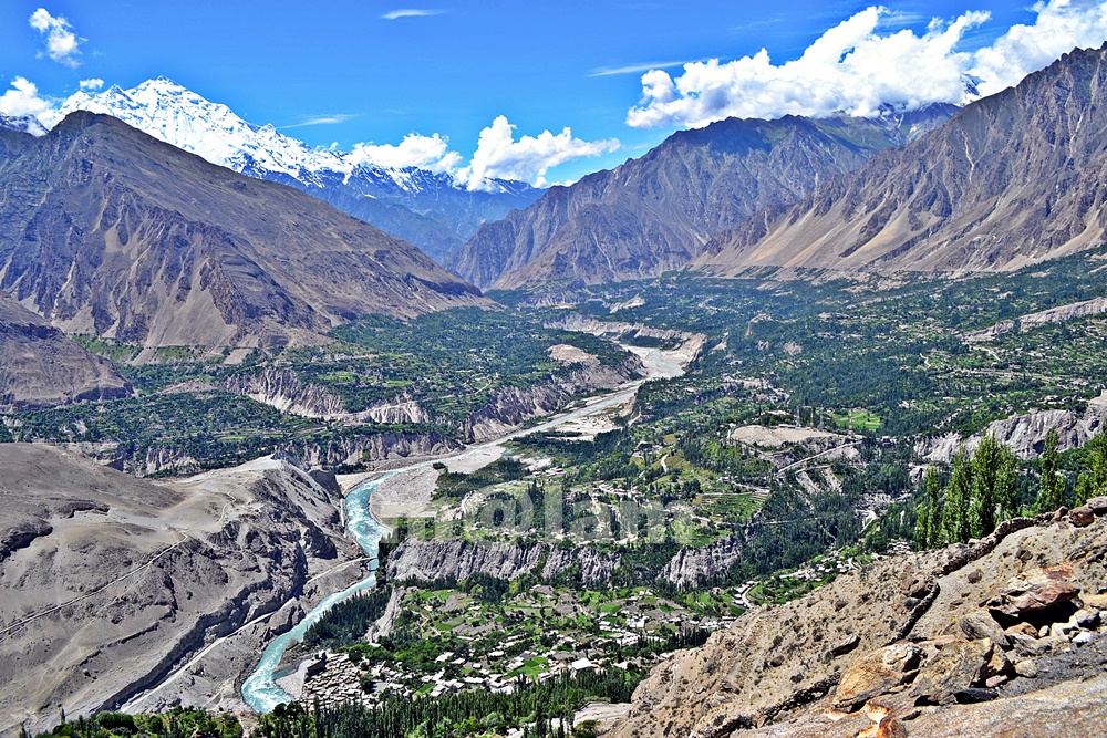
The Karakoram Highway (KKH), N-35, stands as one of the greatest wonders of the modern world. It is an awe-inspiring feat of human determination and ingenuity fondly referred to as the 8th wonder of the world. This 887-kilometer highway traverses along the Indus for 310 kilometers. Before meeting the Indus at the confluence of three mighty mountain ranges, it passes through Gilgit, Hunza, and Khunjerab. The highway runs through the Karakoram Range where 12 out of the 30 highest mountains in the world majestically overlook the KKH. Indeed, there is no other highway on earth that can rival the Karakoram Highway’s richness of attractions and breathtaking vistas.
Origin and Journey of the Karakoram Highway
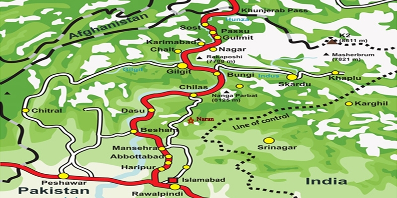
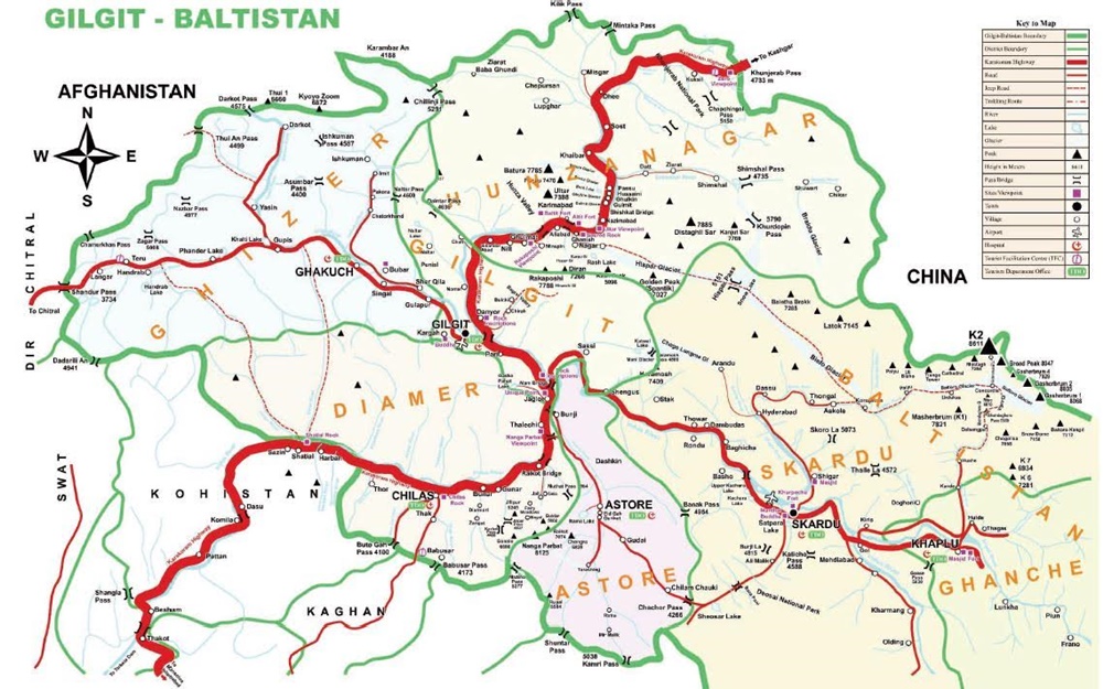
Spanning an impressive 1300 kilometers (800 miles), the KKH commences its journey from the historic city of Hassan Abdal, approximately 45 kilometers from Islamabad on the Islamabad – Peshawar Highway. Its asphalt ribbon weaves through the cities of Abbottabad and Manshera crosses the majestic River Indus at Thakot, and continues on to Gilgit, meandering through the rugged mountains of Besham, Pattan, Sazin, and Chilas, before gracefully passing through Hunza and Sost. Finally, the highway reaches its zenith at the Khunjerab Pass, standing tall at an astonishing 4,733 meters (15,750 ft) above sea level. This pass, also known as Zero Point, marks the border between Pakistan and China. As the highway continues its journey, it enters the high Central Asian plateau and winds down through the Pamirs until it reaches Kashgar, situated at the western edge of the Taklamakan Desert.
Gilgit-Baltistan is a treasure trove of history and natural wonders. It beckons travelers from all corners of the world to witness its splendor. As you explore this enchanting region, you will undoubtedly be captivated by the stories etched into its landscapes and monuments, a testament to the richness of its cultural heritage and the indomitable spirit of its people.
Major Attractions along the Karakoram Highway
The Karakoram Highway is undoubtedly crowned with a plethora of attractions, showcasing a harmonious blend of ancient rock carvings, awe-inspiring petroglyphs, mesmerizing natural beauty, and remarkable man-made marvels. Here are some of the major Karakoram Highway attractions that continue to captivate travelers from around the globe:
The Khyber Pakhtunkhwa Section
The Karakoram Highway passes through the plains, lush hills, and barren mountains of the Khyber Pakhtunkhwa before it enters the Himalayan range of Gilgit-Baltistan which boasts the height of the Karakoram Highway Attractions in the region.
Mansehra Rock Edicts
Ashoka Rocks MansehraLocated on the north side of the town of Mansehra, the Ashoka Rocks bear witness to history with 14 edicts engraved by order of the Mauryan King Ashoka in the 3rd century BC. Although the Kharoshti script inscription is fading away, shelters have been built to protect this invaluable relic, making it accessible to visitors.
The three granite boulders bearing 14 edicts engraved by order of the Mauryan King Ashoka in the 3rd century BC are located on the north side of the town of Mansehra. The inscription bearing Kharoshti script is fading away and almost impossible to see despite the shelters to protect it.
Diamer Section: Threshold to Gilgit-Baltistan
The Diamer Section runs in the rugged mountains for about 200km starting from the border between Tangir and Kohistan to Jaglot near the junction point of three great mountain ranges where Gilgit River and Indus converge.
Shatial Petroglyphs

A treasure trove of Buddhist archaeological wonders, the Shatial Rock Art Carvings or Petroglyphs can be found along the Karakoram Highway, previously known as the Old Silk Route. Carved into large rocks, these petroglyphs depict Jataka tales and Stupas, symbolizing the journeys of monks and pilgrims to Gandhara during the Buddhist era. Sadly, the construction of dams like the Diamer-Basha Dam and Dassu Dam has put these carvings in jeopardy, threatening their existence.
Thalpan Petroglyphs

The town of Chilas is surrounded by striking petroglyphs, particularly the ‘Chilas I’ site, which features inscriptions on both sides of the KKH and is considered a key Karakoram Highway Attraction spot. One of the most striking carvings here is the depiction of a large stupa with flying banners. Across the river, visitors can marvel at stones bearing art showcasing mythical animals, battle scenes, royal lineages, and Buddhist tales. Another site, ‘Chilas II,’ located near the police check post on the KKH, features a huge rock adorned with hunting and battle scenes, a Buddhist stupa, the long-horned ibex, and symbols of fertility.
Nanga Parbat View

The Thakot Bridge is the base point for an unforgettable journey to Fairy Meadows and the base camp of Nanga Parbat, famously known as the “Killer Mountain”. The bridge is situated approximately 78 kilometers south of Gilgit. The Thalechi viewpoint offers travelers a perfect spot to pause and admire the sublime beauty of Nanga Parbat.
Gems in Gilgit Region
Gilgit is the administrative headquarters of Gilgit-Baltistan. The region is enormously blessed with historical monuments and breathtaking natural landscapes. About 90km section of the Karakoram Highway from Jaglot to Guro (Jaglot) passes through the region.
Partab Bridge
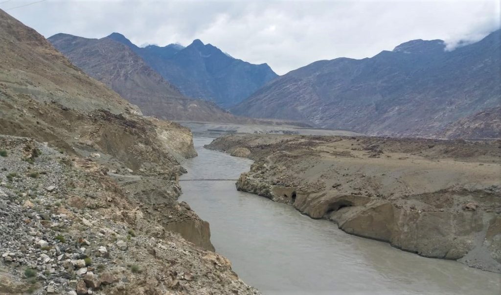
The Partab Bridge is located about 40 kilometers southeast of Gilgit. It played a crucial role in connecting Gilgit with Bunji, Astore, and Kashmir long before the construction of the Karakoram Highway. Built between 1889 and 1893, this suspension bridge served as a vital communication link and facilitated trade. However, during the 1947 revolt when Gilgit gained independence from Dogra Raj, the bridge was burnt down. Despite facing decades of neglect, it was rebuilt after the 2010 floods, standing as a testament to human resilience.
Junction Point of Three Great Mountain Ranges

Jaglot, a mere 40 kilometers southeast of Gilgit, hosts the Junction Point of the Three Mountain Ranges. Here, the Karakoram, Himalaya, and the Hindukush converge. This unique location also marks the confluence of the Gilgit and Indus Rivers. About 5 km to the north, the Skardu road diverges from the KKH. Standing at the monument, visitors are treated to splendid views of the meeting of these three awe-inspiring mountain ranges. The mountain ranges are separated by the Gilgit and Indus Rivers.
Bhup Singh Pari Ambush Point

Approximately 28 kilometers short of the main Gilgit city lies the Bhup Singh Pari, an ambush site on the Karakoram Highway. In 1852, the Raja of Yasin, Gohar Aman, achieved a momentous victory at this location, defeating the Sikh invader Bhup Singh’s army and liberating Gilgit. The site was named Bhoop Singh Pari in honor of this historic triumph.
Uprising Memorial Gilgit

The Uprising Memorial stands as a tribute to the local heroes who bravely rebelled against the Maharaja in 1947. These valiant individuals include Mohammed Babar Khan and Safiullah Beg of the Gilgit Scouts, and Mirza Hassan Khan of the Kashmir Infantry. Through their rebellion, Gilgit-Baltistan was emancipated forever. They arrested Governor Ghansara Singh on Nov 01, effectively breaking free from the rule of the Maharaja of Kashmir.
The Victory Monument of Taj Mughal

The Victory Monument of Taj Mughal is an awe-inspiring commemorative tower, standing tall at 21 feet and 10 inches and spanning 14 feet and 4 inches wide. Situated on a mountain lap in Gilgit town, Gilgit-Baltistan, this ancient monument has witnessed 700 years of history. It was named after Taj-ud-Din Mughal, an Ismaili ruler from Badakhshan who arrived in Gilgit-Baltistan during the 13th century AD. The monument was constructed by his soldiers to celebrate their victorious endeavors.
Danyore Suspension Bridge
The Danyore Suspension Bridge is one of Gilgit-Baltistan’s oldest and most remarkable landmarks. Stretching over 510 feet, this bridge served as a crucial commuting route for locals who had to either take a local raft or a longer detour to reach Gilgit City, the administrative headquarters and capital of Gilgit-Baltistan. Today, it stands as a popular tourist attraction, accessible only to pedestrians and motorcyclists.
Danyore Rock Inscription

The Danyore Rock Inscriptions are a collection of inscriptions dating back to the 7th and 8th centuries A.D. This significant archaeological discovery was first brought to light by Karl Jettmar in 1958. The inscribed rock, locally known as “Likhitu Giri,” is a massive boulder situated within a private house’s premises in Danyore, near Gilgit City. Although not widely known, it remains an essential historical site for a select few individuals and organizations associated with archaeology and tourism.
Chinese Graveyard Danyore

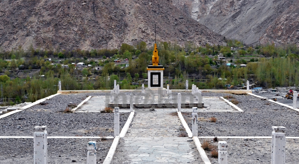
Locally the monument is known as China Yadgar. The Chinese Graveyard serves as the final resting place of courageous Chinese engineers and workers. Those buried sacrificed their lives during the construction of the Karakoram Highway (KKH) in the 1960s and 1970s. The graveyard is located on the Karakoram Highway in Danyore, approximately 10 km from the main Gilgit town. This cemetery stands as a poignant reminder of the contributions made during the highway’s construction.
Memorial Monument, Rahimabad
Memorial monument on the KKH
Located about 35 km from Gilgit on the main Karakoram Highway, the Memorial Monument stands tall, symbolizing a Drilling Machine, and serves as a memorial to the brave individuals who lost their lives during the construction of the Karakoram Highway. Inscribed with “MEMORIAL 103 EB (Engineering Battalion),” the monument pays tribute to the gallant men who made the Karakorams their permanent abode from 1966 to 1972.
Monuments in Nagar The Valley
The Nagar Valley section stretches around 50km from Jaglot to Minapin and perhaps has some of the exciting Karakoram Highway Attractions that include historic monuments and marvelous natural beauty at easy access.
Silk Route segments
Running parallel to the Karakoram Highway, several sections of the ancient Silk Route still exist. They still preserve the rich legacy of ancient trade on this route. Currently abandoned, these sections are mainly used by locals for grazing animals and local travel. These sections have the potential to attract tourists seeking to immerse themselves in history.
Collision Point of Continental Plates
Collision point of continental plates
The collision point of continental plates lies near Chalt Valley on the Karakoram Highway. It is approximately 53 km north of Gilgit town reachable in an hour. It is at this location that the Indian and Eurasian continental plates collided around 50 million years ago to give birth to the mighty mountains. The collision resulted in giving rise to the majestic Himalayan mountain range and forming the Tibetan plateau. The towering Karakoram Mountains in Gilgit-Baltistan were a result of the tremendous pressure exerted on the earth’s crust during this event.
Kino Kutto – the remains of ancient Silk Route
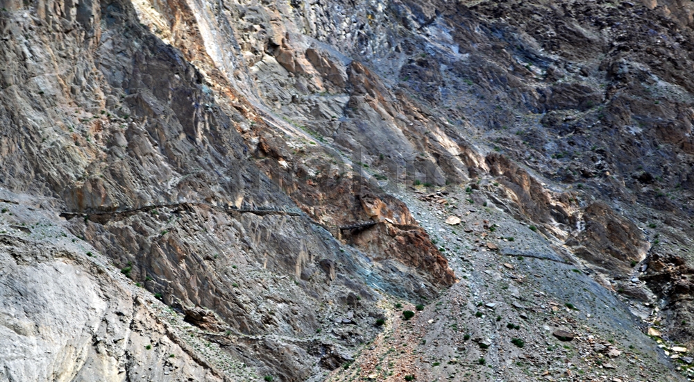
The name “Kino Kutto” refers to the term Black Knee in the local Shina language. This section of the historic Silk Road lies high up on the cliff. The section is located between Budalas Valley of Nagar and Khizrabad village of Hunza. It is no longer in use due to the construction of the Karakoram Highway. The Aga Khan Cultural Services Pakistan has restored a visible section of the road to showcase the historical connection it represents. Kino Kutto offers breathtaking views of Rakaposhi.
Nilt Fort – Traces of History

The Nilt Fort in Nagar is located about 65 km from Gilgit on the main KKH. The fort met its demise during the famous Anglo-Brusho War in 1891. The fort’s resistance was a noteworthy campaign. However, the combined efforts of a superior army and a local conspiracy led to its eventual destruction. Despite this, the Nilt Fort remains etched in history, alongside other gradually disappearing forts. The bygone forts included the historic Mayun Fort in lower Hunza (Shinaki) and the forts in Chaprote, Thol, and Pisson.
Rakaposhi View Point

The Rakaposhi View Point is also known as the “Zero Point of Rakaposhi”. It provides the closest view of Rakaposhi and its breathtaking natural surroundings. Situated along the Karakoram Highway in Ghulmet village of Nagar Valley, this viewpoint promises a mesmerizing experience for all visitors.
Monuments in The Hunza Valley
As you explore the wonders of Hunza Valley, you’ll find yourself immersed in its rich history and mesmerized by its awe-inspiring landscapes. Whether you seek adventure, cultural heritage, or simply wish to bask in nature’s beauty, Hunza Valley offers an unforgettable experience that will stay with you forever.
Queen Victoria Monument

Locally called Malika mo Shikari, the Queen Victoria Monument stands tall on the rock face over Karimabad. It is believed to have been erected by Nazim Khan and can be reached within an hour’s journey from Baltit village, leading straight up to the base of the cliff.
The Kha Basi Cafe

Nestled beneath the shadows of the Altit Fort, in the historical royal garden “the Kha Basi,” lies the unique Kha Basi Café. This classic restaurant, surrounded by apricot trees, offers both a traditional taste and majestic views of the Hunza/Nagar mountains and the Karakoram Highway. Recently renovated, the café now stands as a testament to old-fashioned architecture. It serves as a delightful stop for visitors exploring the region.
Altit Fort

Perched dramatically on a 1000-foot high rocky cliff, overlooking the Hunza River, the Altit Fort stands as a 900-year-old masterpiece in Gilgit-Baltistan. Originally serving as a palace to the local Mirs, the hereditary rulers of Hunza, it later transformed into a fort, showcasing various architectural additions. Today, the award-winning Altit Fort attracts tourists from all over the world, drawn not only by its historical significance but also by its strategic location along the ancient Silk Route.
Baltit Fort

Over 800 years old, the Baltit Fort sits proudly on the moraine of Ultar glacier, offering a commanding view of the Hunza Valley. With its Tibetan-influenced architecture, the fort was built to serve as a stronghold for the rulers of Hunza. Now converted into a museum and cultural center, the Baltit Fort has earned international acclaim and recognition for its historical importance and unique design.
Ganish Historic Settlement

The oldest settlement of Ganish on the ancient Silk Road in The Hunza Valley, beckons history enthusiasts with its rich past. With over 1,000 years of history, this renovated town boasts narrow streets, imposing watchtowers, traditional mosques adorned with striking floral designs, and modern religious centers. The water reservoir near the main entrance adds to the charm of this historic settlement.
Haldikish Petroglyphs and Ancient Rock Inscriptions

Known as the sacred rocks of Hunza, Haldikish houses a 30-ft high and 200-yard-long boulder adorned with inscriptions and carvings from different eras. The upper portion of the rock bears inscriptions in Sogdian, Kharosthi, Brahmi, Sarada, and Proto-Sarada languages, while the lower portion is engraved with images of Ibexes. These carvings provide a fascinating glimpse into ancient times and the cultural heritage of the region.
Attabad Lake

The Attabad Lake is a captivating sight on the Karakoram Highway. It was formed as a result of a massive landslide on January 04, 2010. Despite the tragedy that initially struck the region, the lake has emerged as a leading tourist attraction The lake attracts visitors with its picturesque beauty and sports activities. Tourists from far and wide flock to witness the serene waters and the stunning landscapes surrounding the lake.
Ondra Poygah
The Ondra Poygah, with its 1655 stairs, stands as a testament to human determination. It offers a rare opportunity to marvel at Pakistan’s majestic landscapes. As you ascend, the panoramic views unfold, revealing Attabad Lake, Gulmit village, Passu Cones, Shisper Peak, Ghulkin village, and Ghulkin Glacier. For those seeking an adventure of a lifetime, climbing Ondra Poygah is an experience like no other.
Borith Lake

The Borith Lake is situated at an altitude of 2,600 meters. The lake is a natural wonder surrounded by Borith hamlet in Gulmit, upper Hunza Valley. The lake is a haven for migrating wildfowl and serves as a paradise for bird watchers and nature enthusiasts. Additionally, it serves as a starting point for the enchanting Patundas trek. It also serves as a walking trail leading to nearby villages like Gulkin and Kamaris in Gulmit Village.
Husseini Suspension Bridge & Zip Line

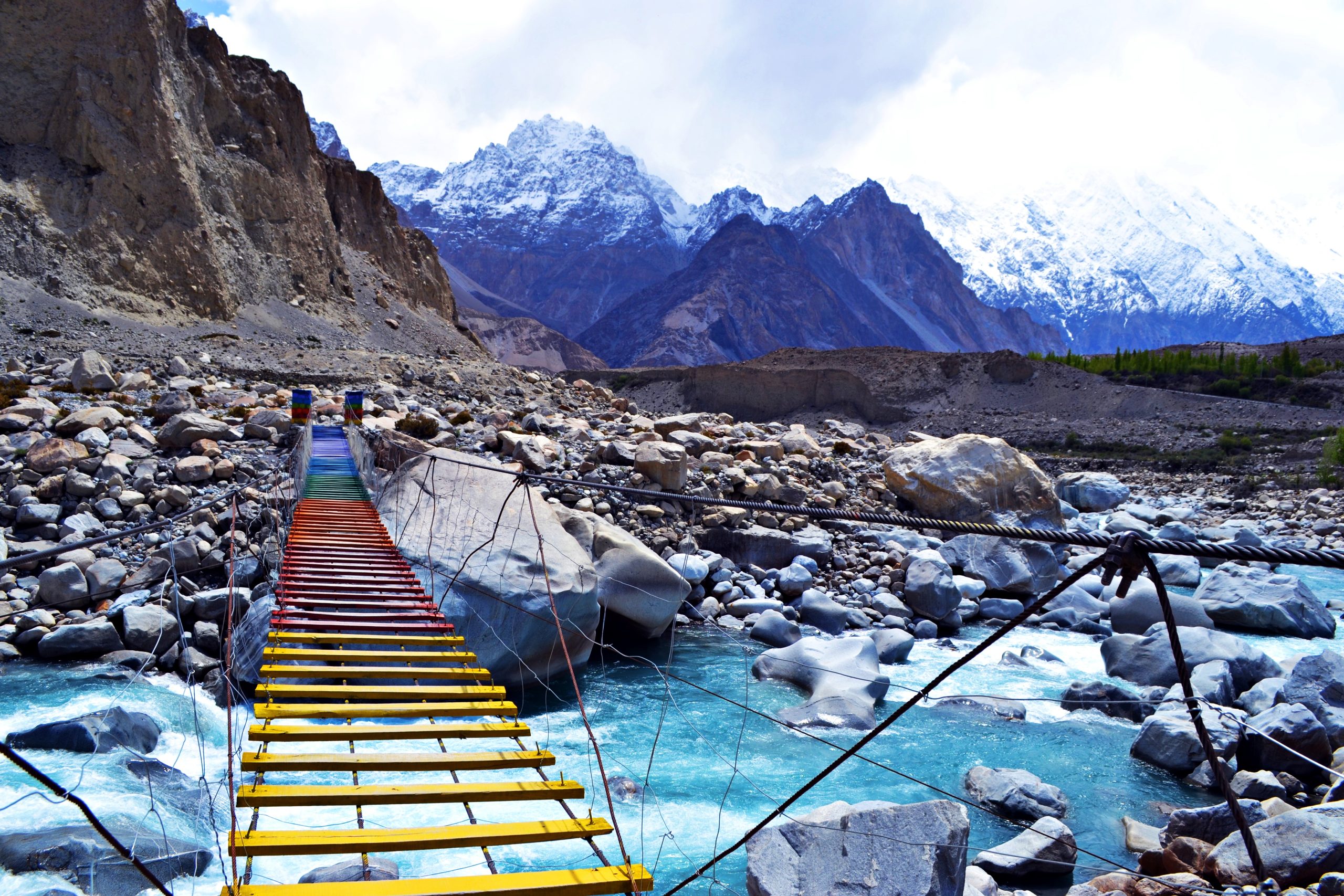
The Husseini Suspension Bridge, despite its rickety appearance, connects Husseini village with Zarabad hamlet over the Hunza River. This nerve-wracking bridge, with considerable gaps between its cables and planks, is a popular attraction for tourists looking for a thrilling experience. Visitors from around the globe flock here to test their nerves and enjoy the adrenaline rush of crossing this bridge. There is a great option for refreshments, including local delicacies and souvenirs.
The Majestic Passu Glacier

The Passu Glacier is a natural wonder stretching over an impressive 20.5 km and covering 115 sq km. The glacier awaits travelers journeying along the renowned Karakoram Highway. Offering a breathtaking panoramic view, this glacier is situated to the east of the highway. From this vantage point, visitors can relish the unparalleled beauty of the entire Passu valley and the awe-inspiring Passu Cones, also known as the Cathedrals. The glacier originates directly from the magnificent 7,478m (24,534 ft) Passu Peak, majestically positioned at the glacier’s far end.
Passu Cones

The majestic Passu Cones stands as a collection of rugged spires in the renowned Karakoram mountain range of Pakistan. These spires soar above a series of mountain peaks located north of Passu Valley. Observing these striking peaks from the opposite side of the Hunza River offers a truly majestic sight for travelers passing along the Karakoram Highway. Basked in the warm glow of the sun, these peaks are known by various names, including Passu Cones, Cathedral Spires, and locally called Tupopdan. However, they are most renowned among tourists as Passu Cathedral, and notably, the British achieved the first successful scaling of this peak back in 1987.
Gircha Mosque

The Gircha Mosque is believed to be one of the oldest mosques in the Gojal region, dating back several centuries. It was built during the early days of Islam’s spread into the mountainous areas of northern Pakistan. The mosque holds cultural and religious significance for the local Ismaili Muslim community, who have preserved it as a cherished relic of their spiritual history.
Sost Town

The Beauty of Sost Nestled in the upper Hunza region, Sost captivates visitors with its enchanting beauty. It is the last town on the Karakoram Highway before reaching the Chinese border. At an elevation of 2800 m, Sost holds a vital position serving as a bustling bazaar. It hosts the Pakistani immigration and customs departments, overseeing the flow of trade goods and passengers between the two nations. Sost port has become a melting pot of diverse people, primarily traders, hailing from various geographical backgrounds. The locals speak the Wakhi and Brushaski languages. A plethora of languages including those spoken in major Pakistani cities, some Chinese dialects, and English as a tourist language can be heard in this vibrant town. To cater to the needs of domestic and international tourists, Sost offers several excellent hotels providing comfortable accommodation facilities.
Khunjerab Pak-China Border

The Khunjerab Pass proudly holds the title of being the highest paved international border crossing. It serves as the connecting point between Pakistan’s Gilgit-Baltistan region and the Xinjiang province of western China. At a breathtaking altitude of 4700 m, this pass is a true marvel of engineering and nature’s grandeur. The iconic Karakoram Highway spans a distance of 1300 km. Its 887 km falls within Pakistan’s territory while the remaining 413 km crosses through the Chinese landscape.
The Karakoram Highway Attractions boasts some of the most spectacular natural wonders, and gems that enchant all who visit. From the lush plains of Khyber Pakhtunkhwa to the icy expanse of the Karakoram Mountains, each destination offers an unforgettable experience. Travelers seeking awe-inspiring vistas, cultural diversity, and unparalleled adventures will find their heart’s desire amidst the stunning landscapes of this remarkable region. Whether you’re an avid mountaineer or a curious explorer, the Karakoram has something extraordinary to offer to everyone.


