
Balochistan

Balochistan
Balochistan

Balochistan Province of Pakistan

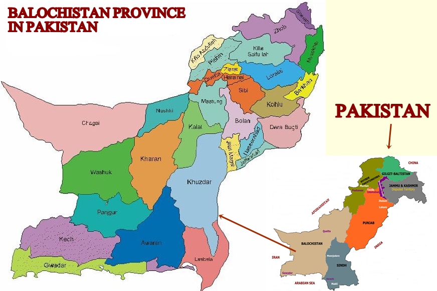
Explore the Enchanting Beauty of Balochistan: Pakistan’s Largest Province Geography and Strategic Location Balochistan, the largest province of Pakistan, sprawls over an expansive area of 347,190 square kilometers, constituting 44 percent of the nation’s total land. Situated at the crossroads of the Middle East, southwest Asia, Central Asia, and South Asia, Balochistan holds immense strategic importance. Bordered by Iran to the west, Afghanistan to the north, the Arabian Sea to the south, and Punjab and Khyber Pakhtunkhwa to the northeast, the province acts as a bridge connecting different regions. Discovering the Land of Diversity Balochistan boasts a diverse landscape, ranging from a 760-kilometer-long southern coastal line to vast deserts, plains, and hilly ranges. Amidst this varied terrain lie numerous cities, each with its unique charm and history. Major Cities to Explore Quetta: The capital city of Balochistan, Quetta is a vibrant hub of cultural richness and historical significance. Gwadar: This port city is renowned for its coastal beauty and strategic maritime location. Ziarat: Known as the “Land of Junipers,” Ziarat offers serene surroundings and a tranquil environment. Turbat: Steeped in history, Turbat is a city with a fascinating past waiting to be explored. Kalat: Formerly the kingdom of the Khan of Kalat, this city carries an air of regal heritage. Hinglaj: A sacred place for Hindus, Hinglaj attracts pilgrims from far and wide. Hub: Located on the border with Karachi, Hub serves as an important town for trade and commerce. Chaman: A northwestern town bordering Afghanistan, Chaman reflects the region’s cultural amalgamation. Pishin: Known for its lush green landscapes and agricultural significance, Pishin captivates visitors. Sibi: The city of the famous Bolan Pass, Sibi is steeped in history and tales of conquest. Taftan: This town on the border with Iran offers a unique glimpse into cross-border interactions. Delving into the Rich History of Balochistan With a history that dates back over 9,000 years, Balochistan holds a treasure trove of ancient civilizations and cultural heritage. The Mehergarh civilization marked a significant shift from a nomadic lifestyle to settled communities, making it a crucial milestone in human history. Balochistan witnessed encounters with renowned conquerors and warriors like Alexander the Great, who had an encounter with the Sibia tribe of Balochistan during his expedition. The region subsequently came under the rule of various empires, including the Ghaznavids, Mongols, and Mughals. The advent of Islam occurred with Muhammad Bin Qasim’s arrival in 712 A.D., which established Muslim rule in the area. The region saw dynastic changes over the centuries, with the Khanate of Kalat emerging in 1758. The British arrived in Balochistan during the 19th century and consolidated their power through treaties with local rulers. Following Pakistan’s creation in 1947, Balochistan became one of the four provinces. Cultural Diversity and Heritage Balochistan is home to a tribal society with a rich cultural tapestry. The major tribes include Baloch, Pashtoon, and Brahvi, each with its language and customs. Balochi handicrafts, particularly their needlework and intricate designs, are famous worldwide. The Melodious Culture of Balochistan Music and dance form an integral part of Balochi culture. Balochi folk songs and tribal poems are sung across the country, and traditional dances like Attan, Chap, Lewa, and Jaffarki represent the region’s identity. The Sibi Festival and Buzkashi Festival are two major attractions showcasing the cultural richness of Balochistan. Languages and Festivals Balochistan is home to three major languages: Balochi, Pashtu, and Brahvi. The Balochi language, with its ancient roots, holds a unique position in linguistic history. Festivals like the Sibi festival and Buzkashi festival attract tourists from far and wide, providing a glimpse into the cultural vibrancy of the province. Discovering Balochistan’s Natural Beauty The province’s diverse landscapes offer a plethora of tourist attractions. From golden beaches along the Arabian Sea to the hills of the Sulaiman Range; Balochistan’s beauty is unparalleled. Notable attractions include the second-largest Juniper Forest in the world in Ziarat, mud eruption volcanoes, archaeological sites, and serene beaches. Economy and Future Prospects Balochistan’s economy is primarily based on natural resources such as natural gas, coal, and minerals. Recent development projects, including the Gwadar deep sea port and the Gwadar International Airport, are expected to bring substantial economic growth to the region. Balochi Food Balochi cuisine is a trove of delectable dishes that celebrate the region’s history, culture, and culinary expertise. Whether you are indulging in the flavors of Sajji or savoring the sweetness of Khoya, Balochi food promises an unforgettable gastronomic experience. So, don’t miss the opportunity to explore the rich culinary heritage of Balochistan and treat yourself to a delightful feast of flavors. Climate and Best Time to Visit Balochistan experiences extreme weather conditions, with cold winters and hot summers. Spring and autumn offer the most pleasant climate for visitors to explore the region’s beauty. A Treasure Trove Awaits With its rich history, diverse culture, stunning landscapes, and hospitable people, Balochistan is a hidden gem waiting to be explored. Embark on a journey to this enchanting province and unravel its many wonders.

Balochistan Province of Pakistan Read Post »
, , , , , , , , , , , ,
The Karakoram Highway
Blogs, Gilgit-Baltistan, Roads & Highways

The Karakoram Highway

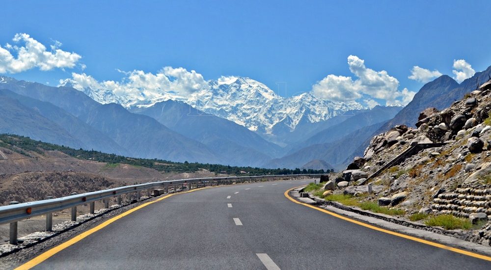
Exploring the Karakoram Highway: A Journey Through History and Scenic Beauty The Karakoram Highway (KKH) stands as a testament to human determination and engineering feats. It connects China and Pakistan via the Khunjerab Pass, situated at an awe-inspiring altitude of 4,733 meters. This epic roadway is not just a trade artery but also a legendary tourist attraction. It offers a captivating blend of historic landmarks, cultural diversity, and breathtaking natural beauty. For adventure enthusiasts, embarking on a journey along the KKH is an absolute thrill. Traversing Pakistan’s Section: A Scenic Odyssey The KKH adventure begins in Hasanabdal, Punjab, Pakistan. It stretches across an impressive 887 kilometers until it reaches the Khunjerab Pass at the Pak-China border. Along this route, the highway meanders through the rugged terrain of Khyber Pakhtunkhwa (KPK). It then follows the course of the Indus River and gracefully navigates the Karakoram and Pamir Mountains. Eventually, it meets the Chinese segment at Khunjerab Pass. In China, this remarkable highway is known as the Friendship Highway. Due to the harsh conditions it was built, it is sometimes referred to as the “Eighth Wonder of the World.” Unveiling the Route: A Glimpse into the Length The total length of the Karakoram Highway spans approximately 1,300 kilometers, with 887 kilometers in Pakistan and 413 kilometers in China. While the new route doesn’t exactly replicate the ancient Silk Route, it closely follows the same region, reviving the spirit of this historic trade network. The construction of the KKH came at a significant human cost, with both Pakistani and Chinese laborers toiling relentlessly to complete each kilometer of this ambitious project. Chinese workers who lost their lives during construction are honored at the Chinese cemetery, China Yadgar, in Danyore near Gilgit. Historic Roots: A Glimpse into the Past Historically, the Karakoram Highway was a vital caravan trail, serving as one of the branches of the ancient Silk Route. Over centuries, traders, pilgrims, warriors, and common folk traversed this route, ushering in profound changes in the social, cultural, and economic aspects of the region. The Saga of Construction: Overcoming Challenges Before the Karakoram Highway was built, the northern areas, now known as Gilgit-Baltistan, attracted the interest of the Russians, Chinese, and British, owing to its strategic significance. However, access to the region was a formidable challenge. In the 1800s, the British, who were in power, aimed to bolster their authority by constructing an all-weather communication infrastructure along the Indus. Realizing this vision was no small feat. Initially, the British improved an old Srinagar foot track, transforming it into a mule track. Later, a seasonal passage was established through Chilas, crossing the Babusar Pass to connect to the Kaghan Valley. Unfortunately, this passage remained open for only about six months a year during the summer. Following the partition of the subcontinent in 1947, the Srinagar road was permanently blocked. This period saw the northern areas divided into several states under local rulers. In 1958, the Indus Valley Road (IVR) project was conceived to create an all-weather road link between Swat and Gilgit. Construction commenced in 1959 as a joint venture between the two governments. Then, in 1966, a Sino-Pak agreement transformed the IVR into the Karakoram Highway. Despite financial constraints and the outbreak of the war between Pakistan and India in 1971, China’s invaluable support enabled the project to continue. Originally planned to stretch from Thakot to the Khunjerab Pass, the entrance point was later shifted to Hasan Abdal, and the project was completed in 1979. The highway was finally opened to the public in 1986. During construction, approximately 800 Pakistanis and 200 Chinese workers lost their lives, primarily due to landslides. Unofficial estimates suggest an even higher toll. The Chinese workers were laid to rest at the Chinese Graveyard in Danyore near Gilgit. A Path to Reconstruction: Upgrading the KKH In June 2006, Pakistan’s National Highway Authority (NHA) and China Road and Bridge Corporation (CRBC) signed an MoU to upgrade the KKH, expanding its overall width from 10 to 30 meters. This expansion aimed to accommodate heavy-duty vehicles, even in extreme weather conditions. Although construction took place, the width remained largely unchanged from the original design. During the construction phase, a significant event occurred on January 4, 2010, known as the Attabad incident. A massive landslide in the Attabad valley of Hunza damaged a section of the highway, creating a 23-kilometer-long lake and disrupting travel along the Karakoram Highway. To restore the road link between Pakistan and China, the construction of tunnels along a revised 24-kilometer route began in July 2012 and was completed in September 2015. This realigned route featured five tunnels and a bridge, rejuvenating the connection between the two countries. The Geopolitical Significance: A Strategic Artery The Karakoram Highway traverses a region marked by towering mountains and geological complexities, where China, Tajikistan, Afghanistan, and Pakistan converge within a 250-kilometer radius. Due to the intricate Kashmir conflict between India and Pakistan, the KKH holds strategic and military importance for these nations, especially Pakistan and China. Beyond geopolitics, the Karakoram Highway has significantly bolstered trade and tourism between Pakistan and China. The construction of the highway resulted in uplifting the living standards of the local population. The China-Pakistan Economic Corridor (CPEC) is set to bring substantial economic gains to the region, with plans to connect the Karakoram Highway to the southern port of Gwadar in Balochistan through the Chinese-aided Gwadar-Dalbandin railway, extending to Rawalpindi. Discovering Tourist Gems: Treasures Along the KKH The Karakoram Highway has earned international acclaim as a niche adventure tourism destination. Beginning in Hasan Abdal, about 50 kilometers from Rawalpindi city, this dual-carriage asphalt ribbon departs from the dusty plains of Punjab, embarking on a journey through the lower Himalayas of Hazara district. As it heads north, it winds through numerous captivating natural and historic sites, ultimately reaching the Pakistan section’s culmination at the Khunjerab border in the upper Hunza valley. This 887-kilometer stretch of the Karakoram Highway in Pakistan is a diverse tapestry of tourist attractions. From the

The Karakoram Highway Read Post »

, , , , , , , , , , , , , , ,
Scroll to Top