World Heritage sites of Pakistan

Shalimar Gardens
Heritage Sites in Pakistan, Monuments, Punjab

Shalimar Gardens

Exploring the Magnificence of Shalimar Gardens in Lahore Unraveling the Marvel of Shalimar Gardens: A UNESCO World Heritage Site The Shalimar Gardens in Lahore stand as an extraordinary testament to Mughal artistry and aesthetics, reaching their zenith during the reign of the Mughal Empire. Commissioned by the visionary Mughal Emperor Shah Jahan, this architectural marvel began its construction on June 12, 1641. It was completed just 18 months later, in 1642. Together with the Lahore Fort, it was designated as a UNESCO World Heritage Site in 1981. Embracing All: From Royalty to the Common Folk While originally intended to serve as an enchanting retreat for royal guests, the Shalimar Gardens welcomed the general public to explore a dedicated section of its lush beauty. The inspiration for these gardens draws from the earlier Shalimar Gardens in Kashmir, built by Emperor Jahangir, the father of Shah Jahan. Remarkably, Shah Jahan himself played an active role in the construction of the Kashmiri gardens. Architectural Grandeur in Nature’s Embrace Covering an expansive 16 hectares, the rectangular garden is enclosed by crenelated walls crafted from red sandstone. It is structured across three terraces, gracefully descending from south to north. Each terrace carries a name infused with meaning: the upper terrace, known as “Farah Baksh,” translates to “Bestower of Pleasure,” the middle terrace, “Faiz Baksh,” means “Bestower of Goodness,” and the lower terrace, “Hayat Baksh,” signifies “Bestower of Life.” 410 Dancing Fountains: A Spectacle of Engineering Mastery The heart of the Shalimar Gardens lies in its 410 fountains, which gracefully rise from the canal, culminating in the marble pools. The hydraulic system that governs these fountains baffles even modern scientists with its ingenious thermal engineering. This engineering brilliance served to cool the air during sweltering summers, offering respite to the garden’s visitors. The upper-level terrace boasts 105 fountains, the middle terrace features 152, and the lower terrace delights with 153. Beyond the Wall: A World Within Within the protective embrace of the garden’s walls, a collection of buildings served diverse purposes. These include: Sawan Bhadun Pavilions Naqar Khana and Its Buildings Khwabgah or Sleeping Chambers Hammam or Royal Bath The Aiwan or Grand Hall Aramgah or Resting Place Khawabgah of Begum Sahib or Dream Place of the Emperor’s Wife Baradaries or Summer Pavilions for Cooling Delight Diwan-e-Khas-o-Aam or Hall of the Special and Ordinary Audience with the Emperor Two Gateways and Minarets Adorning the Corners of the Gardens Nature’s Bounty: A Verdant Oasis The Shalimar Gardens once boasted a lush variety of trees, including Almond, Peach, Apple, Plum, Apricot, Poplar, Cherry, Quince Seedless, Gokcha, Mango, Mulberry, Sapling of Cypress, Shrubs, and Sour and Sweet Oranges. A Historical Odyssey Supervised by the noble Khalilullah Khan in Shah Jahan’s court, the Shalimar Garden project took shape. The garden’s original land belonged to the Arian Mian Family, who were bestowed with the title “Mian” by the Emperor in recognition of their services to the Empire. The Mughal engineers, recognizing the ideal location and soil quality, acquired the land, ultimately leading to the creation of the Shalimar Gardens. The Arian Mian Family retained governance of the garden for 350 years until General Ayub Khan nationalized it, a consequence of their opposition to his imposition of martial law.

Shalimar Gardens Read Post »

, , , , , , , , ,
Makli Necropolis
City Breaks, Heritage Sites in Pakistan, Monuments, Sindh, Tombs, World Heritage Sites

Makli Necropolis

Unveiling the Enigma: Makli Necropolis – A Treasure Trove of History and Artistry Nestled in a diamond-shaped expanse, the grandeur of the Makli Necropolis in Thatta is unparalleled. It boasts of its status as one of the largest graveyards globally covering a sprawling 10 square kilometers. Altogether, the Makli Necropolis houses an astonishing half-million monuments. The graveyard stands as the final resting place for an eclectic mix of individuals, from regal monarchs and erudite scholars to valiant warriors, philosophers, governors, and revered saints. In recognition of its historical significance, Makli Necropolis, therefore, earned its place among the UNESCO World Heritage Sites of Pakistan in 1981. A Journey Through Time: Unraveling the History of Makli Necropolis Delving into the annals of history, Makli Necropolis emerges as the eternal abode for over 125,000 saints. Throughout the ages, this city has undeniably been a beacon of knowledge housing around 400 educational institutions. Here students from the Muslim world and Asia came to hone their skills. Students generally engaged in a diverse array of subjects encompassing religion, politics, and philosophy.  Yet, the enigmatic origins of Makli remain shrouded in mystery. It is widely believed that the cemetery evolved around the shrine of the 14th-century Sufi Hamad Jamali. As for the etymology of “Makli,” two intriguing notions persist. Locals suggest that it signifies “Mecca-like,” while another legend ties it to the pious woman known as “Mai Makli.” Legend has it that her fervent prayers thwarted Sultan Firuz Shah Tughlaq’s conquest of Thatta until her passing. She now rests in Makli near the tomb of Jam Nizamuddin. Thatta enjoyed a glorious stint as the capital of Sindh from the 14th to the 18th centuries. Initially, it was ruled by three successive dynasties – Samma, Argun, and Tarkhan. However, it later came under the dominion of the Mughal emperors of Delhi from 1592 to 1739 before being ceded to Shah Nadir of Iran, marking the beginning of a period marked by decline and neglect. The Architectural Marvels of Makli Necropolis The monuments of Makli Necropolis are a testament to the social and political history of Sindh from the 14th to the 18th centuries. Crafted with exquisite architectural finesse, these tombs and graves epitomize the artistic prowess of their time. The tombs were built by utilizing an array of materials such as sand bricks, stone, and marble. Some of these monuments are opulently adorned with glazed tiles, boasting intricate designs, arched domes, and towers adorned with exquisite Islamic calligraphy and devotional carvings inspired by diverse religious and iconographic traditions. Remarkably, many of these iconic monuments have withstood the test of time, enduring centuries of exposure to the elements. However, preserving this rich heritage for future generations necessitates substantial restoration efforts. Makli Necropolis: A Journey Through Location and Access Situated adjacent to the tip of the Indus River delta, Makli Necropolis lies on the outskirts of Thatta.  It was an ancient bastion of Islamic civilization nestled at the edge of the 6.5-kilometer-long plateau of Makli. This historic site is located approximately 89 kilometers east of Karachi in the Sindh province of southern Pakistan. Makli offers an ideal day trip from the bustling metropolis of Karachi. Navigating the vast expanse of the graveyard is made convenient through its wide streets, ensuring access to all the awe-inspiring monuments. Makli Necropolis undoubtedly stands as a testament to the rich tapestry of history, culture, and artistry. The graveyard has woven itself into the very fabric of this remarkable site. It beckons not only to history enthusiasts but also to travelers, both domestic and international, and devout pilgrims alike, offering a glimpse into an enigmatic past that continues to captivate our imaginations.

Makli Necropolis Read Post »

, , , , , , , , , , , , , ,
Mohenjo-daro UNESCO World Heritage Site in Sindh
Archaeological sites, Sindh, World Heritage Sites

Mohenjo-Daro

Unlocking the Enigma of Mohenjo-Daro: A Dive into Ancient History Mohenjo-Daro also spelled as Mohenjodaro or Moenjodaro, holds a mystique as intriguing as its name, which translates to “Mound of the Dead.” This archaeological gem is nestled in the Sindh province of Pakistan, offering a window into the enigmatic Indus Valley Civilization (IVC) that thrived around 2600 BC. Mohenjo-Daro is one of the six UNESCO World Heritage Sites in Pakistan inscribed in 1980. The city’s original name remains a mystery. The Dawn of Civilization Our story begins around 5500 B.C. when a nomadic tribe settled in the villages west of the lower Indus River. These early settlers, adapting to their environment, mastered tools, constructed humble dwellings, cultivated crops, and tamed animals. Over centuries, as climate patterns evolved, lush jungles and thriving wildlife emerged. Gradually, this nascent community expanded both in size and influence, engaging in trade with regions as distant as Central Asia and the neighboring western territories. By 2600 BC, Mohenjo-Daro evolved into a civilization rivaling the sophistication of Mesopotamia and Egypt. Unveiling the Indus Valley Civilization The Indus Valley Civilization, also known as the Harappan Civilization, boasted two major cities, Harappa and Mohenjo-Daro, along with over 100 smaller settlements. It marked the dawn of urbanization in the Indian subcontinent. From 2600 B.C. to 1700 B.C., this civilization thrived on the fertile plains along the Indus River, showcasing remarkable literacy with a unique script consisting of 250-500 Dravidian characters. This civilization stands tall among the world’s great ancient cultures, with its initial discovery at Harappa in 1921, followed by Mohenjo-Daro in 1922. Rediscovery and Archaeological Endeavors The journey to resurrect Mohenjo-Daro’s glory began in 1922 when R.D. Banerji, an archaeologist with the Archaeological Survey of India, stumbled upon the site. A series of extensive excavations, overseen by renowned archaeologists, occurred until the 1930s. Later, in 1964-65, brief excavations resumed, only to be halted due to preservation challenges. Mohenjo-Daro’s sprawling ruins, stretching across approximately 750 acres, housed a peak population of around 40,000, making it one of the world’s largest and most advanced cities in its era. The city’s construction, characterized by unbaked bricks atop elevated mounds, exemplifies meticulous town planning principles. Urban Planning and Infrastructure Mohenjo-Daro’s urban layout followed a structured grid, with rectilinear buildings dominating the landscape. Most structures were constructed using standardized fired and mortared bricks, complemented by evidence of sun-dried bricks and wooden superstructures. The city comprised two main sections: the Citadel, standing 12 meters high and featuring two grand assembly halls and public baths, likely reserved for religious ceremonies, and the Lower City, comprising courtyard houses for the middle class. These houses featured brick stairs leading to flat roofs and small bathrooms equipped with drains and sanitation facilities. The Magnificent Great Bath A crowning jewel among Mohenjo-Daro’s structures is the Great Bath, astonishingly well-preserved after millennia. Measuring 180 feet by 108 feet, this structure features outer walls that are 7 to 8 feet thick, and lined with bitumen. This remarkable pool may have played a role in religious purification, with dimensions of 39 feet in length, 23 feet in width, and 8 feet in depth. Masterful Water Management Mohenjo-Daro boasted an intricate water management system, highlighted by a central marketplace well and smaller household wells. A sophisticated covered drainage system efficiently handled wastewater, while high-status residences included spacious homes with attached baths and integrated drainage. Many houses featured inner courtyards, their doors opening onto side-lanes. Achievements and Trade The people of Mohenjo-Daro exhibited advanced knowledge of weights, measures, and arithmetic with decimals. Their pottery showcased intricate geometric designs, and they crafted figurines reflecting their beliefs. Major crops included wheat, rice, mustard, dates, and cotton, while animals such as dogs, cats, camels, sheep, pigs, goats, water buffaloes, elephants, and chickens thrived. The presence of guard towers and defensive fortifications suggests that Mohenjo-Daro may have served as an administrative center. Archaeological evidence points to the city’s repeated destruction and reconstruction, with causes attributed to massive Indus River flooding or encroachment, mirroring a resilient spirit in the face of adversity. Unearthed Treasures Excavations at Mohenjo-Daro unearthed a treasure trove of antiquities. The findings include seated and standing sculptures, clay toys, pottery, stone axes, flake knives, coins, and copper and bronze artifacts. Among these, the iconic “Dancing Girl,” a 4,500-year-old bronze statue discovered in 1926, captures the imagination. Noteworthy discoveries also include the priest-king statue and a gold disc suggesting a third eye or “Bindi.” The Mysterious Decline Around 1700 B.C., a shadow fell over the Indus Valley Civilization, including Mohenjo-Daro. The precise cause of this decline remains shrouded in mystery. Theories range from shifts in the Indus River’s course to devastating floods or a decline in rainfall, leading to agricultural woes and eventual abandonment. Recent core drilling in 2015 revealed that Mohenjo-Daro’s true extent surpasses the excavated area. It is hinting at more secrets yet to be unveiled. Location and Accessibility For modern-day adventurers, the archaeological marvel of Mohenjo-Daro is situated approximately 510 km northeast of Karachi, 110 km southwest of Sukkur, and about 28 km from Larkana. Road access is available from Karachi, Bahawalpur, and Multan, making it a feasible day trip. Alternatively, Mohenjo-Daro boasts its airport, providing convenient access for travelers. Whether flying in from Karachi or taking a flight to Sukkur from major cities like Islamabad and Lahore, followed by a road journey to Moenjo-Daro, this ancient treasure is within reach, inviting you to step back in time. Intrigue and wonder continue to surround Mohenjo-Daro, beckoning explorers and historians alike to unlock the mysteries of this ancient marvel. This archaeological wonder serves as a testament to the ingenuity and resilience of a civilization lost to time. It is waiting to share its secrets with those who dare to delve into its history.

Mohenjo-Daro Read Post »

, , , , , , , , , , , , ,
Takht-i-Bahi Monastery view with Mardan city in background
Archaeological sites, Buddhist Heritage, Buddhist Heritage, Buddhist Heritage of Pakistan, Khyber Pakhtunkhwa, World Heritage Sites

Takht-i-Bahi and Sahr-i-Bahlol

Takht-i-Bahi Monastery and Sahr-i-Bahlol Ruins in Gandhara, Pakistan In the heart of Mardan city, Khyber Pakhtunkhwa province, Pakistan, lie two historical treasures: the Takht-i-Bahi Monastery and the Sahr-i-Bahlol ruins. Both structures, dating back to the early 1st century, are situated merely 5 kilometers apart and have earned the prestigious title of UNESCO World Heritage Sites of Pakistan, a recognition bestowed upon them in 1980. Takht-i-Bahi: An Overview The name Takht-i-Bahi is a fusion of two Persian words, “Takht,” signifying “top” or “throne,” and “Bahi,” translating to “spring” or “water.” This nomenclature paints a vivid picture of a monastic complex perched atop a hill, overlooking a meandering stream. Another interpretation suggests that it could mean the “Throne of Origin.” Majestic Architecture The grandeur of the Takht-i-Bahi monastery sprawls across three interconnected spurs on a hill, rising from 36.6 meters to 152.4 meters in height. The primary structures grace the central spur, commanding a panoramic view of Mardan’s plains, accessible via a staircase boasting around 300 steps. Within this complex, you’ll find the main lower stupa court, the upper south stupa court, a Grid Monastery, an assembly hall, covered stepped passageways leading to dimly lit meditation cells, and various secular buildings. Additionally, scattered around the main complex, spread over 4 kilometers, are several units, potentially serving as residential areas or assembly halls, all visible from the hill’s summit. A Scenic Retreat The journey to the top of the Takht-i-Bahi archaeological relics hill rewards visitors with a breathtaking view. One can gaze across the plains, with Peshawar visible on one side and the Malakand Pass and Swat’s picturesque hills on the other. During winter, a thick blanket of fog sometimes envelops the region, shrouding even the nearby Takht-i-Bahi bazaar and Mardan City in an ethereal veil. Discovery and Historical Significance In 1836, the site’s existence was first noted by General Court, a French officer in the service of Maharaja Ranjit Singh. Dr. Henry Walter Bellew, a British medical officer born in India, explored it in 1864, leading to a series of excavations. Harold Hargreaves conducted further research from 1910 to 1911. The travel records of Chinese monk-pilgrim Xuanzang (602-64) also allude to this archaeological marvel. The site’s relics were mentioned for the first time in 1836 by the General Court. Dr. H.W. Bellew’s visit in 1864 resulted in a report detailing the remains and a stupa on the central spur. He also described sculptural fragments, possibly parts of large-scale sculptures. Subsequent excavations in 1871, reported by F.H. Wilcher, unearthed a total of 165 sculptural fragments, primarily depicting seated Buddhas and standing bodhisattvas. Unfortunately, the outcome of the 1911-1913 excavation was less fruitful due to inadequate record-keeping. In 1920, the site underwent significant restoration. Historically, the monastery thrived for 800 years, from the 1st century B.C. to the 7th century A.D. Archaeologists divide its history into four distinct periods: Foundation in the 1st century B.C., evidenced by inscriptions bearing the name of Gondophares (20-46 A.D.). Influence of Kushan kings, such as Kujula Kadphises and Kanishka, in the 1st and 2nd centuries. Development of the Stupa Court and Assembly Hall in the 3rd and 4th centuries. Construction of the Trantic complex with dark cells in the 6th and 7th centuries, overseen by invading Hun rulers. Architecture of Takht-i-Bahi The remains of the complex encompass four main areas: The central “Stupa Court,” features a cluster of Stupas surrounding a central courtyard. Monastic chambers, comprising individual cells arranged around a courtyard. A temple complex, housing several Stupas. Dark cells in the basement, designed exclusively for meditation. The entire structure is constructed using indigenous dressed and semi-dressed stone blocks, set in grey-colored limestone, adhering to Gandhara patterns. The site’s enduring reputation is founded on its remarkable preservation and strategic location, rendering it impervious to hostile incursions. Notably, stone sculptures from the site were relocated to the Peshawar Museum, while the stone inscription of Gondophares now resides in the Lahore Museum. Sahr-i-Bahlol: An Adjacent Enigma The second component of this historical tapestry is the Sahr-i-Bahlol ruins. Also referred to as Seri Bahlol or Sehr-i-Behlol, these ruins belong to a small fortified town from the Kushan period. A mound, approximately 9 meters high, is enclosed by a stone fortification wall. This wall, erected about 3,000 years ago, spans 9.7 hectares but has suffered damage at several points. The site holds remnants of Buddha that have not been adequately excavated. Regrettably, illegal excavations by local residents have led to the discovery of antiques such as statues, coins, jewelry, and utensils. Surrounded by fertile fields, this site now faces the threat of extinction due to ongoing construction. Access to These Treasures Takht-e-Bahi Monastery is located about 2 kilometers east of Takht-e-Bahi bazaar on the Mardan-Swat road, and approximately 15 kilometers north of Mardan city. Mardan itself is situated roughly 70 kilometers from Peshawar and can be reached within an hour and a half. The journey from Islamabad, spanning approximately 150 kilometers, takes around 2.5 hours. Both sites are suitable for a day excursion. Entry Timings: Summer: (1st April – 30th September) 08:00 am to 06:30 pm Winters: (1st October – 31st March) 09:00 am to 04:30 pm Holidays: The monastery remains open on holidays unless high-profile delegations are visiting or special instructions from higher authorities dictate otherwise. Entry tickets: For locals: Rs. 20 Foreign tourists: Rs. 500 Parking charges: All vehicle types: Rs. 50 Photography charges Applicable only to DSLR cameras: Rs. 500 Explore the rich history and architectural splendor of Takht-i-Bahi and Sahr-i-Bahlol, where the past comes to life amidst the enchanting landscapes of Gandhara, Pakistan.

Takht-i-Bahi and Sahr-i-Bahlol Read Post »

, , , , , , , , , , ,
Taxila - A UNESCO World Heritage Site in Pakistan
Archaeological sites, Buddhist Heritage of Pakistan, Punjab, World Heritage Sites

Taxila Buddhist Ruins

Taxila: A Glimpse into Pakistan’s Rich Heritage Taxila’s Past: A Journey through History Taxila, a serene town nestled in the Punjab district of Pakistan, lies to the north of the vibrant twin cities of Rawalpindi and Islamabad, the capital city. The name “Taxila” finds its roots in the Sanskrit term “Taksasila,” which translates to “city of cut stones.” This illustrious town is a treasure trove of historical significance, its archaeological importance was first recognized in the late 1800s by the esteemed archaeologist Sir Alexander Cunningham. In recognition of its historical value, Taxila was designated as a UNESCO World Heritage Site of Pakistan in 1980. Pre-History: Taxila’s Ancient Beginnings The prehistoric legacy of Taxila harks back to the era of microlithic hunters before 3500 BC. Evidence, including the discovery of three notable caves, particularly the one at Khanpur, traces history to the Stone Age. Moreover, the excavation conducted by the renowned late professor Hasana Dani at Saraikala unveiled the existence of agricultural communities that thrived around 3000 BC. The site yielded a plethora of artifacts, including axes, chisels, spatulas, and an array of handmade pottery. Taxila sprawls across an expansive 30 square kilometers, housing over 50 archaeological sites. The majority of these sites, dating from 600 BC to 500 AD, cluster around the Taxila Museum. Among these, three distinct cities—Bhir Mound, Julian, and Mohra Moradu—stand in remarkably preserved states, adorned with intricate stone and stucco images of Buddha. Other notable structural remains encompass Sirsukh, Dharmarajika, Mohra Moradu, Jandial, and Pippala temples, the Giri fortress, and the Dharmarajika, Bhallar, and Kunala stupas (burial mounds). The masonry techniques employed provide insights into their respective periods of origin, chronicling the significant stages in the life of the great sage. The Political Scenario of Taxila Throughout its history, Taxila has been a cradle of peace and knowledge. The city once thrived as a bastion of Buddhism and a renowned center of learning. Its prosperity was inextricably linked to its strategic location at the crossroads of three major trade routes: the Royal Highway from Eastern India, Western Asia, and Central Asia. Taxila’s historical narrative is one of diverse rulers and empires. It began with the Achaemenid Empire in the 6th century BC, followed by the conquest of Alexander the Great in 326 BC. However, Alexander’s reign was brief, and the mantle passed to the Mauryan dynasty in 321 BC. Under the rule of the great Ashoka, Taxila reached its zenith, becoming a prestigious center of learning. Nevertheless, following Ashoka’s demise in 232 BC, the dynasty crumbled. The Indo-Greeks briefly ruled Taxila until 190 BC, succeeded by the Scythians, who held sway from the 2nd century to the middle of the 1st century BC. It was during the Indo-Greek era that Taxila experienced its most creative period, particularly in the realm of Gandhara art. The longest period of rule was enjoyed by the Kushans, who arrived in 50 AD and ruled until the 5th century when the White Huns devastated the region. Taxila University is believed to have existed even before Ashoka’s time, in the 7th century BC. Philosophers congregated here to establish their own schools of thought and provide instruction in various fields, including military science, medicine, political science, philosophy, religion, language, literature, and grammar. Taxila: The Cradle of Gandhara Culture Taxila, alongside Swat and Charsadda (formerly Pushkalavati), emerged as pivotal centers for culture, trade, and learning. They witnessed the construction of numerous monasteries and stupas, alongside Greek and Kushan towns such as Sirkap and Sirsukh. The Gandhara civilization not only exerted spiritual influence but also nurtured the renowned Gandhara culture, art, and learning. These centers gave rise to a unique form of sculpture, globally recognized as Gandhara Art. Taxila Museum: A Glimpse into the Past The ivy-clad Gothic-style Taxila Museum houses a wealth of archaeological treasures. It ranks among Pakistan’s best-maintained museums, drawing both local and foreign tourists. Its exhibits include an extensive collection of coins, jewelry, surgical instruments, vessels, grinders, rare inscriptions, plaster and terra-cotta figures, and stone and stucco sculptures. These artifacts are meticulously arranged in chronological order and comprehensively labeled. Taxila’s Archaeological Wonders Taxila’s archaeological landscape boasts a diverse array of stupas, mounds, and ancient cities, each with its unique history and significance. Here’s a brief overview: Bhir Mound: From the Achaemenid to Bactrian-Greek Periods Bhir Mound, Taxila’s earliest city, dates from the 6th century BC during the Achaemenid period to the 2nd century BC Bactrian-Greek period. It was situated on a small plateau along an ancient trade route. The city’s earliest evidence includes cramped houses made of early rubble and irregular streets. However, the Mauryan era brought consistent masonry, followed by lime-coating plaster during the Indo-Greek period, signifying a period of maturity. Notably, King Ambhi received Alexander the Great and his armies at Bhir Mound. The city’s glorious history eventually culminated with the construction of Sirkap by the Bactrian Greeks, marking a well-planned city. Sirkap: The Greek Legacy Sirkap, established by Bactrian Greek king Demetrius around 180 BC, became Taxila’s primary city with a significant Greek influence in its layout. The city was said to be encircled by a 6-meter thick rubble wall extending for 5 kilometers. Sirkap was first identified and excavated in 1912, with more comprehensive excavation carried out in 1944 and 1945 by Mortimer Wheeler and his team. The city of Sirkap lies on the opposite side of the Tamara Stream. Its layout reveals meticulous planning, with affluent houses lining the main street and more modest dwellings further afield. Notably, Sirkap featured an advanced drainage system for managing runoff water and soaking wells for sewage. The main street also encompasses the Royal Residence, Sun Temple, Apsidal Temple, Double-Headed Eagle Stupa, and the Jain Temple. Remarkable findings include gold and silver jewelry discovered in a house near the Stupa, as well as Indian punch-marked bent bar coins. Sirkap thrived under various rulers, including Greeks, Scythians, Parthians, and finally the Kushans. Sirkap remained a thriving city until 10 BC when King Kanishka of the Kushans founded Sirsukh. Intriguingly, excavations

Taxila Buddhist Ruins Read Post »

, , , , , , , , ,
Forts, Punjab, World Heritage Sites

Rohtas Fort

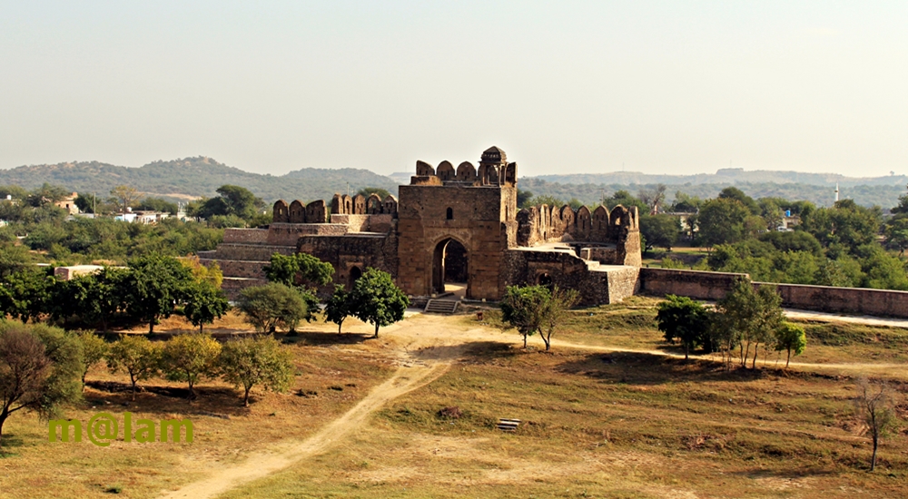
Rohtas Fort: History and Architecture at Heights Rohtas Fort, also known as Qila Rohtas, stands as an iconic symbol of military ingenuity and architectural brilliance in Punjab, Pakistan. Nestled in the Tilla Jogian Range on the Pothohar Plateau, this UNESCO World Heritage Site (since 1997) is a masterpiece of early Muslim military architecture in Central and South Asia. Its robust design, sprawling walls, and intricate gateways have earned it a place among the most remarkable historical sites in the region. Location and Setting Strategically positioned 91.5 meters (300 feet) above its surroundings, Rohtas Fort is perched on a hill overlooking the confluence of the Kahān River and the seasonal Parnal Khas stream. The fort rises to an elevation of 819 meters (2,687 feet) above sea level, covering an impressive 70 hectares (170 acres). Just 16 kilometers northwest of Jhelum, it lies near the historic Grand Trunk Road, a vital trade route connecting Afghanistan to the plains of Punjab. A Glimpse into History The Vision of Sher Shah Suri (Sur Period) Following his victory over Mughal Emperor Humayun in 1541, Sher Shah Suri commissioned the construction of Rohtas Fort to consolidate his power and thwart a potential Mughal resurgence. Tasked with suppressing the pro-Mughal Ghakkar tribe, the fort was designed to be both an impregnable fortress and a statement of authority. Despite initial resistance from the local populace, construction progressed under the supervision of Todar Mal, a Punjabi Khatri minister. The fort’s architectural blend of Persian, Afghan, and local influences reflects Sher Shah’s vision for an enduring legacy. Mughal Period After Sher Shah’s death, the fort’s strategic significance dwindled. It was ceded to Humayun in 1555, who used it briefly before his empire shifted focus to more ornate structures like the nearby Attock Fort. While Emperor Akbar and Jahangir rested at Rohtas during their travels, its plain military style was less appealing to the Mughals, who preferred structures adorned with gardens and elaborate designs. Sikh Empire and British Era In 1825, the fort fell under the control of the Sikh Empire, with Gurmukh Singh Lamba capturing it from Nur Khan, a Ghakkar chief. It served as an administrative hub during the Sikh reign until the British annexed the Punjab region in 1849. Architectural Marvels of Rohtas Fort Main Fortifications The fort’s defensive walls stretch over 4 kilometers, enclosing an area capable of housing 30,000 soldiers. Rising between 10 to 18 meters in height and 10 to 13 meters in thickness, the walls feature 68 bastions, 1,900 battlements, and 12 monumental trap gates. Inner Citadel A secondary wall 533 meters long divides the inner citadel from the rest of the fort. Structures like Haveli Man Singh, Shahi Mosque, Baolis (stepped wells), and the Rani Mahal add historical depth to the citadel’s interior. Notable Structures Haveli Man Singh Constructed between 1550 and 1614, this prominent structure reflects Hindu architectural elements and offers commanding views of the surroundings. Rani Mahal The Rani Mahal, near Haveli Man Singh, was once a four-room structure, now reduced to a single room with visible foundations. Shahi Mosque Located near the Kabuli Gate, this modest yet ornate mosque is one of the most decorated buildings within the fort. Baolis (Stepped Wells) The fort features three Baolis—Main Baoli, Shahi Baoli, and Sar Gate Baoli—essential for water storage during sieges. The Gates of Rohtas FortRohtas Fort is renowned for its 12 intricately designed gates, each with unique historical and architectural significance: Sohail Gate: Named after Saint Sohail Bukhari, this gate showcases exemplary masonry from Sher Shah’s time. Shah Chandwali Gate: Honoring Saint Shah Chandwali, this gate connects the citadel to the main fort. Kabuli Gate: Facing west towards Kabul, this double gate opens to a width of 3.15 meters. Shishi Gate: Distinguished by its glazed tile embellishments, representing an early example of this technique. Langar Khani Gate: A double gate leading to a Langar Khana (Mess hall or Canteen). Talaqi Gate: Named after “Talaq” (divorce), as legend has it Prince Sabir Suri’s entry through this gate was ill-fated. Mori or Kashmiri Gate: Opening northward, it’s aptly named for its orientation towards Kashmir. Khwas Khani Gate: An ode to Khwas Khan, one of Sher Shah Suri’s most prominent generals. Gatali Gate: Facing the village of Gatali, it served as a vital crossing point for the River Jhelum to the Kashmir Valley. Tulla Mori Gate: Located on the eastern side, it’s more of an entrance than a gate, featuring a bastion. Pipalwala Gate: Resembling the Tulla Mori Gate, it’s a small entrance. Sar Gate: Known as “Sar (water),” this gate includes a small entrance with a bastion and a Baoli adjacent to it. Modern-Day Preservation Despite centuries of exposure, much of Rohtas Fort remains well-preserved. Restoration efforts have focused on key areas like the Chandwali Gate, which was recently rebuilt. However, natural erosion and neglect have caused some damage, such as the partial collapse of the Talaqi and Gatali Gates. Visitor Information Easily accessible at 16km northwest of Jhelum, and 8 km south of Grand Trunk Road makes it a convenient stop for travelers exploring the region. Rohtas Fort is a must-visit for history enthusiasts and architecture lovers. Plan Your Visit Rohtas Fort’s rich history and breathtaking vistas make it a destination that blends culture, history, and natural beauty. Whether you’re tracing the footsteps of emperors or marveling at ancient craftsmanship, the fort offers an unforgettable experience. Nearby Attractions Maqbara Khair un Nisa Tilla Jogian Forts in Pakistan Baltit Fort Altit Fort Red Fort Muzaffarabad Lahore Fort Kot Diji Fort Derawar Fort

Rohtas Fort Read Post »

, , , , , , , , , , , , , , ,
Scroll to Top