Tourist attractions in Pakistan

Shalimar Gardens
Heritage Sites in Pakistan, Monuments, Punjab

Shalimar Gardens

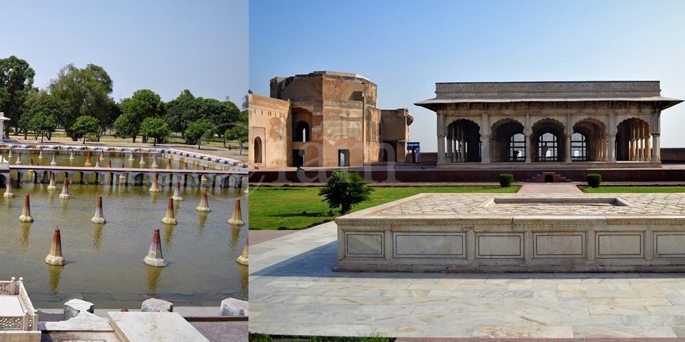
Exploring the Magnificence of Shalimar Gardens in Lahore Unraveling the Marvel of Shalimar Gardens: A UNESCO World Heritage Site The Shalimar Gardens in Lahore stand as an extraordinary testament to Mughal artistry and aesthetics, reaching their zenith during the reign of the Mughal Empire. Commissioned by the visionary Mughal Emperor Shah Jahan, this architectural marvel began its construction on June 12, 1641. It was completed just 18 months later, in 1642. Together with the Lahore Fort, it was designated as a UNESCO World Heritage Site in 1981. Embracing All: From Royalty to the Common Folk While originally intended to serve as an enchanting retreat for royal guests, the Shalimar Gardens welcomed the general public to explore a dedicated section of its lush beauty. The inspiration for these gardens draws from the earlier Shalimar Gardens in Kashmir, built by Emperor Jahangir, the father of Shah Jahan. Remarkably, Shah Jahan himself played an active role in the construction of the Kashmiri gardens. Architectural Grandeur in Nature’s Embrace Covering an expansive 16 hectares, the rectangular garden is enclosed by crenelated walls crafted from red sandstone. It is structured across three terraces, gracefully descending from south to north. Each terrace carries a name infused with meaning: the upper terrace, known as “Farah Baksh,” translates to “Bestower of Pleasure,” the middle terrace, “Faiz Baksh,” means “Bestower of Goodness,” and the lower terrace, “Hayat Baksh,” signifies “Bestower of Life.” 410 Dancing Fountains: A Spectacle of Engineering Mastery The heart of the Shalimar Gardens lies in its 410 fountains, which gracefully rise from the canal, culminating in the marble pools. The hydraulic system that governs these fountains baffles even modern scientists with its ingenious thermal engineering. This engineering brilliance served to cool the air during sweltering summers, offering respite to the garden’s visitors. The upper-level terrace boasts 105 fountains, the middle terrace features 152, and the lower terrace delights with 153. Beyond the Wall: A World Within Within the protective embrace of the garden’s walls, a collection of buildings served diverse purposes. These include: Sawan Bhadun Pavilions Naqar Khana and Its Buildings Khwabgah or Sleeping Chambers Hammam or Royal Bath The Aiwan or Grand Hall Aramgah or Resting Place Khawabgah of Begum Sahib or Dream Place of the Emperor’s Wife Baradaries or Summer Pavilions for Cooling Delight Diwan-e-Khas-o-Aam or Hall of the Special and Ordinary Audience with the Emperor Two Gateways and Minarets Adorning the Corners of the Gardens Nature’s Bounty: A Verdant Oasis The Shalimar Gardens once boasted a lush variety of trees, including Almond, Peach, Apple, Plum, Apricot, Poplar, Cherry, Quince Seedless, Gokcha, Mango, Mulberry, Sapling of Cypress, Shrubs, and Sour and Sweet Oranges. A Historical Odyssey Supervised by the noble Khalilullah Khan in Shah Jahan’s court, the Shalimar Garden project took shape. The garden’s original land belonged to the Arian Mian Family, who were bestowed with the title “Mian” by the Emperor in recognition of their services to the Empire. The Mughal engineers, recognizing the ideal location and soil quality, acquired the land, ultimately leading to the creation of the Shalimar Gardens. The Arian Mian Family retained governance of the garden for 350 years until General Ayub Khan nationalized it, a consequence of their opposition to his imposition of martial law.

Danyore Rock inscriptions
Gilgit-Baltistan

Danyore Rock Inscriptions

Danyore Rock Inscriptions: A Journey through Time The boulder bearing the Danyore Rock Inscriptions nestles amidst the breathtaking landscapes of Danyore. It is just a stone’s throw away from Gilgit city in Gilgit-Baltistan, Pakistan. These ancient engravings provide a captivating glimpse into the 7th and 8th centuries. However, despite its historical significance, this hidden gem remains shrouded in obscurity. It was known primarily to a select few involved in the fields of archaeology and tourism. Danyore: Where History Meets Natural Beauty Danyore is situated along the iconic Karakoram Highway leading to Hunza, south of Gilgit. It boasts a scenic setting nestled between the Gilgit River and the Hunza River. While the journey from Gilgit to Danyore is a mere 10-minute drive, locating the exact site of the Danyore Rock Inscriptions can prove to be a challenge. Additionally, the signage on the KKH guiding visitors has vanished. Moreover, the boulder itself is tucked away on a narrow street within the premises of a private residence. Surprisingly, the current occupants of the house are unaware of the historical significance concealed within their walls. The Enigmatic Inscriptions This colossal rock measures an impressive 13 x 7 feet. It proudly bears the names of Tibetan monarchs who once held sway over Gilgit during the 7th and 8th centuries. These names are meticulously inscribed in a five-line Sanskrit script, utilizing the late Brahmi script. Dr. Ahmed Hasan Dani, a renowned Pakistani archaeologist, posits that Prince Kumaramatya, a scion of the lineage mentioned in the Hatun inscription of the Ghizer Valley, likely commissioned these inscriptions. The inscriptions bestow royal titles upon Jayamangala Vikramaditya Nandi of the Vikramaditya family, crowning him as Patola Shahi Shahanushahi and Parama-Bhattaraka. Unraveling the Purpose Dr. Dani’s research suggests that the Danyore Rock Inscriptions may have served as a commemoration of a local ruler’s triumph. It may possibly signify the defeat of a Tibetan incursion in the upper Indus Valley. It is also documented that the Kingdom of Great and Little Bolor came under Tibetan suzerainty around A.D. 725.  Unfortunately, the ravages of time have taken a toll on the rock, causing the inscriptions to fade significantly. Nevertheless, it remains a poignant testament to the historical prominence of Sanskrit in the region and a priceless artifact that demands preservation. A Portal to Ancient Gilgit-Baltistan The Danyore Rock Inscriptions open a mesmerizing gateway into the ancient history and cultural heritage of Gilgit-Baltistan. As we stand in awe of these ancient carvings, it becomes evident that this land was once a vibrant center of civilization. It marks the influence of Tibetan rulers and the prevalence of Sanskrit as a dominant language. Basically, safeguarding these inscriptions and promoting awareness of their significance are vital steps in preserving the region’s historical legacy for generations to come. In the tranquility of Danyore, the Danyore Rock Inscriptions silently bear witness to a bygone era. Concealed within the heart of this town, these age-old engravings transport us through time, illuminating the rich history and cultural tapestry of Gilgit-Baltistan. Let us acknowledge the paramount importance of these inscriptions and unite in their conservation, ensuring that the legacy of our forebears endures for countless years ahead. FAQs (Frequently Asked Questions)What are the Danyore Rock Inscriptions? The Danyore Rock Inscriptions are ancient carvings on a large boulder located in Danyore, Gilgit-Baltistan, Pakistan. These inscriptions date back to the 7th and 8th centuries A.D. and bear the names of Tibetan kings who ruled Gilgit during that era. Where exactly are the Danyore Rock Inscriptions located? The Danyore Rock Inscriptions are situated on the premises of a private house in Danyore, across Gilgit City. The town of Danyore is easily accessible from Gilgit, and the rock can be found off the main Karakoram Highway, leading through a narrow street to the private house. What language are the inscriptions written in? The inscriptions on the rock are written in Sanskrit, using the late Brahmi script. Moreover, the five-line inscription reveals the names of Tibetan rulers and confers royal titles upon them. Why are the Danyore Rock Inscriptions significant? These inscriptions provide valuable insights into the ancient history of the region, particularly the rule of Tibetan kings in Gilgit during the 7th and 8th centuries. They offer evidence of Sanskrit’s presence in the area and commemorate the achievements or conquests of the rulers. What efforts are being made to preserve the Danyore Rock Inscriptions? Due to the limited knowledge of the inscriptions’ significance, preservation efforts have been minimal. However, raising awareness about their historical importance is a need of the time. It is possible through collaboration with local authorities and heritage organizations to ensure the conservation of this valuable archaeological site. Remember, the Danyore Rock Inscriptions are a fragile piece of history, and it is our responsibility to protect and cherish them for future generations to appreciate.

Islamabad Tourist Attractions
City Breaks, Islamabad

Islamabad Tourist Attractions

Must-See Islamabad Tourist Attractions Islamabad’s Tourist Attractions include major tourist spots found within the territory of the capital city. Surrounded by the lush greenery of the Margalla Hills, an extension of the majestic Himalayan Mountain ranges; Islamabad offers a scenic backdrop that changes with the seasons, showcasing a spectrum of natural colors. Islamabad, the capital city of Pakistan, stands out among global capitals for its unique proximity to nature. Few other capitals enjoy such a harmonious connection with the natural environment. Renowned for its breathtaking beauty, Islamabad also boasts a rich historical heritage dating back to the Stone Age. Evidence of ancient human settlements, including relics and human skulls found along the banks of the Soan River, attests to its long history. Below are the details of Islamabad Tourist Attractions. HISTORIC AND CULTURAL MONUMENTS  Shah Faisal Mosque Named after King Faisal bin Abdul Aziz of Saudi Arabia, the Shah Faisal Mosque is the largest mosque in South Asia and 6th largest in the world, located in the foothills of Margalla Hills. It was completed in 1986 at a hefty cost of USD 120 million. Bearing a contemporary design, inspired by a desert Beduine tent-shaped structure with four 80m high minarets in corners, the mosque was designed by the Turkish Architect Vedat Delokay. The interior of the Faisal Mosque is simple and elegant, with white marble walls and floors, and large chandeliers hanging from the ceiling. The prayer hall is surrounded by arched colonnades and is free from any decorative distractions, allowing worshipers to focus on prayer and reflection. The mosque can accommodate over 100,000 worshipers at a time and is open to visitors of all faiths and is a symbol of the unity and diversity of Pakistan. There is no entry fee as such but to deposit shoes it costs a minor fee. Pakistan Monument The Pakistan Monument is a popular tourist attraction and a symbol of national pride for Pakistanis. Constructed in 2004, the Pakistan National Monument in Islamabad is a heritage site and symbol of national progress built to commemorate the struggle for independence and the formation of Pakistan. The design of the Pakistan Monument is inspired by the Islamic architecture of the Mughal era. The four petals represent the four provinces (Balochistan, North West Frontier Province, Punjab, and Sindh), while the three sandwiched smaller petals represent the three territories (Gilgit-Baltistan, Azad Kashmir, and the Federal Capital Islamabad). The petals are made of granite and marble and are adorned with intricate Islamic calligraphy and patterns. The aerial views of petals represent a crescent and the central star together represents the Pakistan flag. It is illuminated at night and provides a stunning view of Islamabad and its surrounding areas. Shah Allah Ditta Caves Shah Allah Ditta Caves are situated to the west of Islamabad, about 15 km from Golra interchange, in a centuries-old village called Shah Allah Ditta (also known as Sadhu ka Bagh). The more than seven hundred-year-old village was named after a Mughal period Darvesh. The caves, however, are believed to have been a meditation spot for Buddhist monks in the 4th century BC. There are only two caves on both sides of the spring which contain traces of human existence from ancient times. Hindu families lived in Shah Allah Ditta before the partition and the caves were used for their daily worship. There is a pathway right next to the village that is said to have been used as a route from Kabul to the Taxila by Alexander the Great and Sher Shah Suri while Mughal rulers and emperors often passed through while traveling from Afghanistan to the Hindustan. Saidpur Model Village Saidpur, a 500-year-old village nestled in the Margalla hills’ foothills, boasts a rich historical legacy and draws numerous visitors. Named after Said Khan, son of Sultan Sarang, the Gakhar chief of the Pothohar region in Babur’s Mughal era, it serves as a captivating microcosm of diverse cultures coexisting harmoniously. Within its confines lie a Hindu temple, Sikh Gurdwara, and Sufi tomb, offering a unique tapestry of spiritual traditions. Originally converted into a Hindu place of worship by Mughal commander Raja Man Singh, the village has undergone restoration, transforming into a cultural hotspot and heritage site. Its terraced mud houses, showcasing traditional architecture, handicrafts, and local cuisine, provide insight into Pakistani rural life. Notable landmarks include the 16th-century Rama Mandir, dedicated to Lord Rama, and a 20th-century Gurdwara serving educational purposes. Additionally, a photo gallery depicts the village’s early lifestyle, predating Islamabad’s emergence as the capital. PARKS IN ISLAMABAD Rose & Jasmine Garden The Rose and Jasmine Garden is a picturesque public garden managed by the Capital Development Authority. Situated within the recreational zone of Shakarparian Hills, it lies adjacent to the Islamabad sports complex and Aabpara market, along the Srinagar Highway. Covering an area of 20,360 square meters, the garden boasts a diverse collection of nearly 250 varieties of roses and a dozen types of jasmine. Visitors to the nearby Pakistan Monument and Shakarparian often include a stop at this enchanting garden in their itinerary. The garden offers key amenities such as a parking area, seating areas, a walking and cycling track, and a cafeteria (Dhaba) for the convenience of the public. Japanese Childern Park Japanese Park is a children’s playground situated at the base of Margalla Hills, adjacent to Margalla Road near the F6 sector, close to Islamabad Zoo. Spanning approximately 10 acres, this park is equipped with modern amenities and is a popular destination for children and families alike. Established on 30 December 1985, it stands as a unique gift from Japan to the children of Pakistan. The park features vibrant nurseries with colorful flowers and various play areas for children, including swings, climbing nets, jumping castles, trampolines, zip lines, bouncing cushions, and slides. It offers a plethora of entertaining activities for kids to enjoy. Cherry blossom trees adorn the park, lending it an authentic Japanese ambiance. Additionally, there is a small refreshment area within the park offering snacks and beverages for

Victory monument of Taj Mughal
Gilgit-Baltistan, Monuments

Victory Monument of Taj Mughal

Exploring the Majestic Victory Monument of Taj Mughal Unveiling the Remarkable Tale of the 700-Year-Old Commemorative Tower in Gilgit, Pakistan Nestled gracefully upon the southern mountains of Gilgit town, Gilgit-Baltistan, Pakistan, stands the splendid Victory Monument of the Taj Mughal. Undoubtedly, the monument is a testament to history, triumph, and timeless beauty. With a history spanning over 700 years, this commemorative tower bears witness to the legacy of Taj-ud-Din Mughal. Taj-ud-Din was an Ismaili ruler from Badakhshan who graced Gilgit-Baltistan with his presence during the 13th century AD. Erected by his devoted soldiers, this monument stands tall at 21 feet and 10 inches, with a circumference of 14 feet and 4 inches, perpetuating the memory of his glorious victory. Journey to the Past: Unveiling the Monument’s Origin The Victory Monument of the Taj Mughal finds its sacred abode against the stunning backdrop of the southern mountains of Gilgit city. The Monument majestically sits about 1000 feet above Gilgit town. This awe-inspiring edifice not only oversees the enchanting villages of Gilgit and Danyore but also narrates a saga of victory and courage that continues to captivate the hearts of those who tread its path. Unveiling the Pathways: A Scenic Staircase Adventure Gone are the days of arduous treks and intricate routes. In order to promote history and tourism, access to the monument has been made easy. From the city center or the bus station, one can drive towards Serena Hotel in Jutial and follow the signboards leading to the hiking point. The monument is now reachable via a splendid flight of stairs, gracefully winding its way through rocky trails. These trails, adorned with the raw beauty of nature, create an immersive experience that heightens the anticipation of the forthcoming spectacle. As each step is taken, a sense of excitement and wonder builds, propelling us toward our destination. Cycle Track Marvel: A Gateway from Barmas to Jutial Adding to the allure of this journey is the newly constructed water channel Cycle Track, connecting Barmas to Jutial, Gilgit. One can do the monument from Barmas, the southern end of Gilgit, as well while enjoying the majestic views of Gilgit and surrounding valleys along the cycling trail. This ingeniously designed pathway presents an alternative route, one that promises a unique blend of adventure and tranquility. Unveiling the Monument’s Grandeur Architectural Resplendence: A Glimpse into the Monument’s Construction Erected upon the ridge of the Rocky Mountains, the Victory Monument stands as an embodiment of architectural finesse. Crafted meticulously with local stone and clay, this circular tower resonates with the echoes of a bygone era. Yet, the passage of time has not been without its effects, as the monument’s structural integrity slowly wanes, hinting at the ephemeral nature of existence. Temporary support has been tendered to its base, while the southern façade bears the marks of weathering, urging for a much-needed restoration. A Panoramic Tale: The Enchanting Vistas from the Monument’s Peak Gazing from the heights of the Victory Monument, one is rewarded with an awe-inspiring panorama that unfurls before the eyes. Gilgit town, stretching from Bagrot in the east to Baseen in the west, is caressed by the winding embrace of the Gilgit River. The tower, known as “Shikaari” in the local Shina language, offers an unobstructed view of the surrounding valleys, cradled by vigilant mountain sentinels. Embracing the Experience: Best Time & Route to Embark Packing Essentials: The Checklist for a Memorable Voyage The monument can be accessed at any time of the year. During peak summers, only early morning or late afternoon time is suggested to avoid heat. Preparation is the key to a fulfilling visit to the Victory Monument. As you tread upon the barren mountain terrain, remember to arm yourself with a water bottle, ensuring hydration amidst the arid landscape. Similarly, the scorching sun necessitates the application of sunburn cream, while sturdy shoes guarantee secure footing. Complete your ensemble with sunglasses, and a hat/cap, and equip yourself with a camera or cell phone to capture the moments that unfold. Embarking Beyond: Exploring Gilgit’s Treasures Beyond the resplendent Victory Monument, Gilgit extends an invitation to delve into its treasury of attractions. Venture into the embrace of ancient history as you encounter the 7th-century Karga Buddha, a silent sentinel of bygone times. In addition, Biddulph House, Hal Ga Naal, Hanzal Stupa, Gilgit Suspension Bridge, Chinar Bagh, Buddhist Rock Carvings, and the hiking track near KIU await your exploration. Each movement narrates a unique chapter in the tale of Gilgit’s legacy. Charting Your Course: Navigating to Gilgit Accessing Gilgit is a journey that intertwines with the thrill of the destination. Flights operate daily from Islamabad, weather permitting, offering a gateway to this realm of wonder. Likewise, roadways pave the way from Islamabad along the (Karakoram Highway) KKH and from Chitral via the Gilgit-Chitral road. While those journeying from Kashgar in China tread the path along the KKH—the months from May to mid-October emerge as the optimal time to embark on this odyssey. Capturing Memories: The Must-Have Essentials A pilgrimage to Gilgit demands thoughtful preparation. Ensure a water bottle accompanies you, quenching your thirst amid the landscapes. The embrace of the sun necessitates the shield of sunburn cream, while sturdy footwear guarantees steadfast steps. Moreover, bedecked with sunglasses and a hat, seize the moment with a camera or cell phone, encapsulating memories that endure. The Victory Monument of Taj Mughal stands as a living testament to a bygone era. It proudly stands as a beacon of triumph that graces the mountains of Gilgit. As you traverse the path to this historical marvel, let the vistas of Gilgit and the tales.

Phander Valley
Gilgit-Baltistan

Phander Valley

Unveiling the Enchanting Beauty of Phander Valley: A Nature Lover’s Paradise Nestled in the heart of the Ghizer District of Gilgit-Baltistan in Pakistan lies the breathtaking Phander Valley. This hidden gem is renowned for its unrivaled grandeur and sheer natural beauty. What truly sets this valley apart is, in fact, its remarkable display of diverse colors, changing with the seasons. Moreover, the tranquil deep blue rivulet gracefully meandering through the valley’s center adds to the enchantment, creating a scene straight out of a dream. Exploring Phander’s Geography Phander finds its home in the Gupis Valley of Ghizer district, within the mesmerizing Gilgit-Baltistan region. Ghizer district shares its borders with Gilgit District to the east, Hunza-Nagar to the northeast, Diamer to the south, and Chitral district of Khyber Pakhtunkhwa to the west. A Journey Through Nature’s Masterpiece As you embark on a journey through the Ghizer District towards the Shandur Pass, you’ll be greeted by a series of tiny valleys nestled along the Gilgit River. The landscape here is undoubtedly a testament to nature’s creativity, stretching from Gilgit to Lunger near Shandur. Each stretch leading up to Lunger boasts traditional houses surrounded by lush gardens, bountiful fruit orchards, and meticulously terraced fields. Attractions Along the Way The road to Phander Valley is adorned with numerous attractions that promise an enjoyable journey without the slightest hint of fatigue. As your eyes feast on the vibrant green fields, enchanting fruit orchards and gardens, pristine lakes like Khalti Lake and Phander Lake, and the sky-blue river flowing gracefully between valleys connected by suspension bridges, you’ll find yourself immersed in a unique and awe-inspiring experience. Likewise, the clear glacial waters and natural springs that dot the landscape further add to the visual delight. A Mosaic of Cultures Beyond its diverse landscape, Ghizer District boasts a rich tapestry of cultures that make it even more enticing. The residents here speak a multitude of languages, including Shina, Khuwar, Burushaski, and Wakhi, depending on the region. These diverse cultures coexist harmoniously, and the warm and welcoming locals lead simple lives, sustaining themselves primarily through agriculture. The Pinnacle of Scenic Beauty While the entire district is a visual treat, the Phander Valley stands out as a heavenly masterpiece. This bowl-shaped valley is formed by a natural barricade at its eastern end, where the PTDC Motel overlooks the breathtaking Phander Lake. Additionally, a government rest house perched on a ridge offers panoramic views of both the valley and the lake. A Nature Lover’s Paradise Phander Valley boasts a natural setting that is truly one-of-a-kind. Lush plains cover the valley’s base, separated by the calm, deep blue waters gently flowing downstream. These waters further teem with trout, a regional delicacy that every tourist should savor. Easy Access to Paradise Phander is conveniently located approximately 173 kilometers west of Gilgit town, making it easily accessible. The journey typically takes around five hours, depending on the pace. The Gilgit-Chitral road is undergoing reconstruction currently. Upon completion, the journey will be reduced to about 3 hours. For those traveling via Chitral, Phander can also be reached via the scenic Shandur Pass. Phander Valley is a testament to the splendor of nature, offering a harmonious blend of diverse landscapes, rich cultures, and serene beauty. Whether you’re an adventure seeker or a nature enthusiast, this enchanting valley promises an unforgettable experience that will leave you in awe of the natural world’s wonders.

Rama Lake
Gilgit-Baltistan

Rama Lake

Exploring Rama Lake: A Himalayan Gem in Gilgit-Baltistan Nestled at a breathtaking altitude of 3800 meters, Rama Lake stands as an iconic jewel in the pristine Astore district of Gilgit-Baltistan, Pakistan. This high-altitude lake, perched gracefully above Rama Meadows, offers a remarkable natural spectacle. While the lake itself is awe-inspiring, the immediate surroundings have faced challenges from illegal logging, resulting in a treeless landscape. Nonetheless, Rama Meadows, situated at 3300 meters, remains a lush oasis, adorned with towering trees like pine, cedar, fir, and juniper. Unveiling the Attractions Rama Lake: A Magnificent Oasis Rama Lake takes center stage as one of the most alluring attractions, magnetizing a substantial influx of both domestic and international tourists throughout the year. This picturesque lake, nestled against the southern ridge of Nanga Parbat, offers a captivating spectacle. On a clear day, it mirrors the snow-capped majesty of Nanga Parbat, known as the “Killer Mountain” (standing tall at 8126 meters), creating a mesmerizing inverted image. A Nature Lover’s Paradise The environs of Rama Lake harbor a diverse range of flora and fauna. Here, one can encounter various medicinal plants and a fascinating array of wildlife, including the golden marmot, ibex, musk deer, snow leopard, and rock partridge. Along the trail from Rama Meadows to the lake, you’ll encounter three small lakes known as “Sarot” in the local Shina language. Explore Rama’s Beauty A Must-Visit Destination Rama Valley and Rama Lake are undisputed must-visit destinations for travelers making their way to or from Deosai. For those with limited time, the lake can be explored as a captivating day excursion from Gilgit. For a more comprehensive journey, consider an ideal itinerary that encompasses Fairy Meadows, Rama, Deosai, and Skardu, offering a week-long adventure. To elevate your experience, don’t miss the opportunity to add Gilgit and Hunza to your travel program. Weather: A Seasonal Symphony Seasonal Transformation Rama Meadow undergoes a dramatic transformation with the changing seasons. During winters, it’s blanketed in pristine snow, while in summers, it transforms into a vibrant green paradise, making Rama an idyllic camping spot. The lake, too, transitions from being frozen in winter to a refreshing oasis where you can take a dip on a warm summer day. Rama Lake presents an ideal option for a half-day hike from Rama Meadows, promising an unforgettable experience. Accessing Rama: Your Gateway to Adventure Connecting to Astore Rama is part of the rich tapestry of valleys and key tourist destinations in Astore, Gilgit-Baltistan. To reach this paradise, travelers can take advantage of the well-connected transportation network. Astore itself is conveniently linked to Gilgit, which is accessible both by air (weather permitting) and by road. The iconic Karakoram Highway (KKH) ensures a year-round road link between Islamabad/Rawalpindi and Gilgit. While in the summer, the Gilgit-Naran route via the Kaghan Valley and Babusar Pass offers a scenic drive. The Journey From Islamabad, embark on a scenic drive along the Karakoram Highway, heading towards Gilgit. After crossing Raikot Bridge, continue for approximately 20 more minutes, following the sign directing you to Fairy Meadows. Take the right turn indicated, leading you on a 45-kilometer (about 2-hour) journey to Astore Bazar. From there, it’s just another 9 kilometers of uphill driving, leading you to Rama Lake. The Lake is nestled within the embrace of Rama Meadows, where the primary campsite awaits, ready to welcome adventurers. Rama Lake in Gilgit-Baltistan is a natural wonder that beckons explorers and nature enthusiasts from far and wide. Its picturesque beauty, diverse wildlife, and easy accessibility make it a must-visit destination for those seeking an unforgettable Himalayan experience. Whether you’re planning a day trip or a week-long adventure, Rama Lake promises to leave an indelible mark on your soul.

Lahore Fort and Shalimar Garden
Heritage Sites in Pakistan, Islamic Heritage, Punjab, World Heritage Sites

Lahore Fort and Shalimar Garden

Exploring Lahore’s Magnificent Lahore Fort and Shalimar Garden: A Glimpse into Mughal Grandeur Lahore, the cultural heart of Pakistan, boasts two magnificent Mughal-era treasures: the Lahore Fort and Shalimar Garden. These architectural marvels continue to stand as symbols of pride and prestige in Lahore, having earned their rightful place as UNESCO World Heritage Sites of Pakistan in 1981, owing to their remarkable collection of Mughal monuments that epitomize the artistic and aesthetic zenith of the empire. The fort is located at the northwest corner of the walled city of Lahore while the Shalimar Gardens are situated along the Grand Trunk Road some 5 kilometers northeast of the main Lahore city. The monuments are located at a distance of 7 kilometers from each other. Dating back to 1the 7th century, both masterpieces reflect the true artistic expression of the Mughals at its peak.  The fort is the only monument that represents the complete history of Mughal architecture in Pakistan. The Shalimar garden, built by Emperor Shah Jahan in 1642, still retains the glorious Persian and Islamic tradition is a fine example of Mughal gardens. Lahore Fort: A Historical Marvel The Lahore Fort, also known as Shahi Qila, sprawls across an impressive 20 hectares. This irregularly designed citadel features 21 notable monuments, some dating back to the reign of Emperor Akbar. In the 17th century, during the peak of the Mughal Empire, the fort underwent extensive reconstruction. Its origins can be traced back to 1566 when Emperor Akbar laid the foundations for the modern Lahore Fort. Interestingly, the fort’s architectural design seamlessly blends Islamic and Hindu motifs, a testament to its rich history. As time passed, subsequent Mughal Emperors made alterations to the fort. Following the decline of the Mughal Empire, it served as the residence of Ranjit Singh, the founder of the Sikh Empire. Later, the British made significant modifications to suit their needs. Shalimar Garden: A Natural Paradise The Shalimar Gardens in Lahore represent an exceptional Mughal garden complex, seamlessly merging natural beauty with architectural grandeur. Commissioned by Emperor Shah Jahan in 1641, these gardens were completed in 1642, showcasing the pinnacle of Mughal artistry. Encompassing 16 hectares, the garden’s rectangular layout is enclosed by crenelated walls constructed from red sandstone. It is divided into three terraces, each with its own distinctive name. The upper terrace is named “Farah Baksh” (Bestower of Pleasure), the middle terrace “Faiz Baksh” (Bestower of Goodness), and the lower terrace “Hayat Baksh” (Bestower of Life). One of the most remarkable features of the Shalimar Gardens is its intricate water circulation system, comprising 410 fountains. These fountains, distributed throughout the three terraces, create a mesmerizing spectacle. The garden’s thermal engineering was designed to provide cooling relief to visitors during scorching summers, a feat that continues to baffle scientists today. While initially intended to entertain royal guests, a specific section of the Shalimar Gardens was open to the general public. Located just 5 kilometers northeast of Lahore’s city center, the garden’s land originally belonged to the Arian Mian Family. In recognition of their contributions to the Mughal Empire, Emperor Shah Jahan bestowed upon them the prestigious Mian title. The Lahore Fort and Shalimar Garden stand as enduring testaments to the Mughal Empire’s architectural and artistic brilliance. Their historical significance and timeless beauty continue to captivate visitors, making them indispensable landmarks in Lahore’s rich cultural heritage.

Babusar Pass
Khyber Pakhtunkhwa, Passes

Babusar Pass

Babusar Pass: Discover the Mesmerizing Beauty of the Himalayas Babusar Pass, also known as Babusar Top, sits majestically at an elevation of 4,170 m (13,690 ft) as a captivating mountain pass in the Diamer District of Gilgit-Baltistan. Located about 70 km from Naran on the Naran-Gilgit road, this pass marks the southern boundaries of Chilas and is accessible from the Karakoram Highway by a 40km uphill paved road through Thak Nullah. It, therefore, forms a crucial link between the northernmost edge of the scenic Kaghan Valley in the Khyber Pakhtunkhwa (KPK) province of Pakistan and the Karakoram Highway in the Gilgit-Baltistan region and serves as a gateway to unparalleled beauty. Historical Significance of Babusar Top In the annals of history, Babusar Top held immense importance as it was a part of the ancient summer route that provided access to the Gilgit-Baltistan area long before the construction of the all-weather Karakoram Highway. This route was a lifeline from 1947 to 1978, connecting Gilgit-Baltistan with British India and subsequently with Pakistan. Even before the existence of Babusar Pass, the Burzil Pass (4,100m) served as the caravan route from Srinagar to Gilgit through Astore. Notably, the Kaghan Valley runs almost parallel to the Neelum Valley of Azad Kashmir, separated only by a mountain ridge. Accessible Yet Challenging While the Kaghan road through Babusar Pass offers a shorter and more picturesque path to Gilgit-Baltistan compared to the Karakoram Highway, its accessibility is limited. The pass remains open only for a brief period from early June to early November, subject to unpredictable weather patterns. The rest of the year, it becomes inaccessible due to heavy snowfall, rendering the Kaghan Valley a winter wonderland. Exploring the Enchanting Beauty The journey from Naran to Babusar Top is a mesmerizing experience, offering travelers a plethora of scenic vistas. Frozen peaks stand tall in the background, complementing panoramic valleys, vibrant waterways, lush forests, picturesque pastures, and green terraced fields. One of the prime attractions is the serene Lulusar Lake, a location that demands a peaceful stopover. Babusar Pass, with its magnetic charm, draws thousands of tourists on a daily basis during summer. For those visiting Naran, Babusar Top is an essential destination and a preferred day excursion and is always bustling with lively tourists, captivated by the awe-inspiring views of the surrounding mountains. It remains snow-capped during early summers, making it a delightful spot for tourists embarking on an excursion from Naran or heading towards Gilgit-Baltistan. The site is a photographer’s paradise, offering a splendid view from the top. On a clear day, the summit of Nanga Parbat, also known as the “killer mountain,” and the majestic peak of Malika Parbat (17,000 feet), the highest peak in the KPK district, are visible. Additionally, the snow-covered peaks of Kashmir present striking views on sunny days. The Source of Life: Melting Waters from the Mountains Surrounding Babusar Top Numerous streams and creeks converge into the Kunhar River, ultimately flowing into the Jhelum River in Kashmir. One of the most significant attractions is the stunning Lulusar Lake, the largest lake in the region, nourished by the waters of the Kunhar River. The Kunhar River gracefully flows through the length of Kaghan Valley, offering tourists the opportunity to experience rafting in this idyllic setting. Looking Ahead: Tourism Development Besides zip lines, there are a few decent restaurants on the top, and new hotels and restaurants are in the works. These facilities will undoubtedly enhance the appeal of Babusar Top, attracting more tourists to this enchanting destination. Traveler Tips: Enjoying Babusar Top to the Fullest Stock Up: Travelers planning to visit or pass through Babusar Top should ensure they have an adequate supply of food, warm clothing, necessary medicines, and a photography kit for capturing the beauty. Check the Weather: The weather can be unpredictable, so it’s essential to check the forecast before embarking on the journey. Altitude Considerations: Individuals prone to altitude sickness should avoid prolonged stays at the top to ensure a safe and enjoyable experience. Avoid Off-Season Travel: Due to extreme weather conditions, it’s best to avoid traveling during the off-season when the pass is closed. Vehicle Maintenance: Make sure your vehicle is in top condition, and have enough fuel for a hassle-free trip. Network Connectivity: Be aware that the top lacks cellular network coverage, making it impossible to make phone calls. Babusar Pass stands tall as an emblem of natural beauty, offering an unforgettable experience for adventurous souls and nature enthusiasts. As you venture through this captivating region, be prepared to be mesmerized by the grandeur of the Himalayas and the enchanting landscapes that unfold before your eyes. Whether you seek solace in the serene surroundings or embark on thrilling adventures, Babusar Top has something special for every traveler seeking the allure of the mountains. So, plan your journey wisely, and let the majestic Babusar Pass leave an indelible mark on your heart and soul.

Hiran Minar
Monuments, Punjab

Hiran Minar

Unveiling the Splendor of Hiran Minar: A Testament to Jahangir’s Love for Wildlife In the heart of Sheikhupura – a city brimming with history, stands the magnificent Hiran Minar. It’s a towering masterpiece that soars 30 meters into the sky. Its origins trace back to the year 1606 when it was commissioned to honor the memory of Mansraj, a cherished pet deer of the illustrious 4th Mughal emperor, Jahangir, also known as Prince Saleem. During Jahangir’s reign from 1605 to 1627, Sheikhupura held the prestigious status of a royal hunting ground. In fact, the Mughal rulers had an ardent passion for the art of hunting. Remarkably, Hiran Minar still stands today in splendid condition, continuing to captivate the hearts of tourists from around the world. The Birthplace of Hiran Minar Formerly known as Jahangirabad, Sheikhupura derived its name from “Sheikhu,” the affectionate nickname of Emperor Jahangir himself. Positioned approximately 40 kilometers northwest of the provincial capital, Lahore, Pakistan, modern-day Sheikhupura boasts a rich historical legacy. Hiran Minar, nestled about 9 kilometers west of Sheikhupura, graces the cityscape with its majestic presence. Unraveling the Hiran Minar Complex Hiran Minar encompasses not only the monumental tower but also an eastward-facing octagonal two-story structure crowned with an open pavilion. The very structure is known as Daulat Khana or Bara-Dari (of twelve doors). This structure sits at the very heart of a rectangular water tank. Notably, both Daulat Khana and the tank were additions made in 1607 and 1620, respectively. It’s worth mentioning that the term “Baradari” might be somewhat misleading, as it typically refers to a structure with twelve openings. Whereas, Daulat Khana is an octagonal building that features only one entrance on each side. Daulat Khana served as a cherished royal retreat for the emperor, accessible via a bridge extending westward from the tower. The ground floor of Daulat Khana grants entry from the four main directions, leading to smaller square rooms, which in turn, provide access to the king’s chamber. This central chamber, surrounded by eight subordinate rooms, forms the heart of Daulat Khana. Among these eight rooms, four are square and of smaller dimensions, while the remaining four are octagonal, boasting a more spacious layout. Every room offers pathways to the central king’s chamber as well as connections with one another. The Enigmatic Water Tank The water tank encircling Daulat Khana features charming pavilions adorned with pyramidal roofs and entrances on all four sides. Notably, each side of the tank is equipped with shallow brick ramps. The ramps provide easy access to the resident wildlife of the hunting park, allowing them to quench their thirst. The water level within the tank was meticulously maintained through a network of channels and catchment basins. A Monument Born from Love The tale that led Emperor Jahangir to order the construction of the tower and a grave for his beloved deer is both poignant and remarkable. Tragically, the emperor accidentally put to death Mansraj while attempting to hunt another deer in the very area where Hiran Minar now stands. Overwhelmed by grief, Jahangir made the heartfelt decision to inter Mansraj at the very spot where he had met his untimely end. In memory of his cherished pet, the emperor commanded the construction of Hiran Minar. Subsequently, the once-royal hunting ground was transformed into a protected sanctuary, and the practice of hunting was strictly prohibited. This extraordinary tale stands as a rare testament to the profound bond between man and wildlife. It’s a symbol of reverence for animals in an era when such sentiments were virtually unknown elsewhere in the world. Hiran Minar not only graces the landscape of Sheikhupura but also stands as a testament to Jahangir’s enduring love for his favorite deer, Mansraj, and his commitment to preserving the natural world. Intriguing, historically significant, and a true marvel of architecture, Hiran Minar remains an enchanting destination for travelers seeking a glimpse into the past and a profound connection to the natural world.

Passu Cathedral
Gilgit-Baltistan, Mountains

Passu Cones

Passu Cones: A Natural Wonder in Pakistan’s Karakoram Range Hidden in the grandeur of Pakistan’s Karakoram Mountain Range, the Passu Cones offer an unforgettable sight. These jagged, cathedral-like peaks, situated north of the serene Passu Valley and across the Hunza River, rise dramatically into the sky. Renowned for their distinctive shape, these spires have become one of the most iconic and photographed landscapes in the Gilgit-Baltistan region, showcasing the untamed beauty of Pakistan’s northern terrain. The Mystique of Passu The origins of the name “Passu” remain a mystery, but the region itself is a treasure trove of natural and cultural attractions. Visitors can explore the charming Passu Village, marvel at the icy grandeur of the Passu Glacier, admire the soaring Passu Peak, or gaze at the famed Passu Cathedral. All of these wonders are easily visible from the legendary Karakoram Highway (KKH), making the journey as memorable as the destination. Where Are the Passu Cones? The Passu Cones are located near Passu Village, approximately halfway between Gilgit and the Khunjerab Pass, the border crossing between Pakistan and China. Situated about 50 km from Karimabad and 150 km from Gilgit, they are part of the Batura Muztagh Range within the Karakoram system, one of the world’s most challenging and awe-inspiring mountain ranges. Locally known as Tupopdan, these peaks are also referred to as the Passu Cathedral or Cathedral Spires. They first captured international attention when British mountaineers scaled them in 1987, further enhancing their mystique and allure. What Makes Passu Cones Unique? The Passu Cones are celebrated for their dramatic, pyramid-like structure, which creates a stunning silhouette against the sky. Standing at an elevation of 6,106 meters (20,033 feet), they form a striking backdrop to the lush valleys and the tranquil Hunza River below. Unlike many remote peaks in the region, the Passu Cones are easily accessible from the Karakoram Highway, making them an ideal destination for travelers of all levels. Their ability to reflect light at sunrise and sunset creates a mesmerizing display of colors, from golden hues to deep shadows, captivating visitors and photographers alike. Captivating Beauty of Passu Cones The Passu Cathedral is perhaps the most recognizable feature of the Passu Valley. Soaring nearly four kilometers from its base, this pyramid-like peak is a testament to the raw power of nature. As the day begins, the first rays of sunlight illuminate the cones’ jagged edges, casting a play of light and shadow across their surface. During winter, the peaks become cloaked in snow, adding a pristine white brilliance to their already majestic presence. At sunset, the peaks glow with golden and bronze hues, offering an unforgettable visual treat for spectators. Getting to Passu Cones By Road: From Gilgit, take the Karakoram Highway toward Hunza. Public buses and private vehicles are readily available. By Road: From China, take the Karakoram Highway toward Hunza via Khunjerab Pass. Public buses and private vehicles are readily available from Tashkurghan. By Air: Fly to Gilgit from Islamabad and continue by road to the Hunza Valley. Tips for Visitors Stay hydrated and be mindful of altitude changes. Wear sturdy shoes, especially if you plan to trek. Respect the customs and traditions of the local community. Bring a camera—every moment at the Passu Cones is worth capturing. Why Visit Passu Cones? The Passu Cones epitomize the wild beauty of northern Pakistan, offering an experience that is both awe-inspiring and deeply moving. Whether you’re chasing adventure, capturing stunning photographs, or simply soaking in the serenity of nature, the Passu Cones promise memories that will last a lifetime. Best Time to Visit The ideal time to visit the Passu Cones is between April and October, when the weather is pleasant, and the natural surroundings are at their most vibrant. Spring and autumn are particularly stunning, with blooming flowers and colorful foliage. Winter brings a magical, snow-covered charm but can make road access more challenging. Nearest Attractions Passu Glacier Hussaini Suspension Bridge Borith Lake Batura Glacier Borith Lake Afsang View Point Ondra Poygah Attabad Lake Haldikish Yak Grill Rainbow Bridge Khunjerab Pass

Scroll to Top